November 16 , 2022.
Italy / Sicily , Etna :
Statement on ETNA activity, 15 November 2022, 19:47 (18:47 UTC).
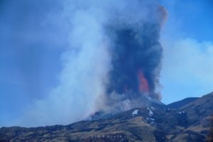
The National Institute of Geophysics and Volcanology, Osservatorio Etneo, communicates that the monitoring networks recorded at 7:22 p.m. (6:22 p.m. UTC), that the average amplitude of the volcanic tremor showed an increase from 4:55 p.m. UTC, reaching its maximum value at 5:30 p.m. UTC. Currently, the amplitude of the tremor shows fluctuations with medium to high values. The centroid locations of the sources are located in the Bocca Nuova crater area at an altitude of 3000 m above sea level. Infrasound activity remains at low levels and is localized in the Bocca crater New.
Inclinometer monitoring stations in the summit area detected significant variations between 00:00 and 04:00 GMT on November 15, 2022. A first variation was observed between approximately 00:00 and 00:30, and a second variation between approximately 02:50 and 03:30, accumulating tilt not exceeding 1 microradian, and indicating lift centered approximately in the summit area. In the same time intervals, the dilatometric station of Monte Ruvolo (DRUV) recorded significant variations.
Since 04:00 the inclinometer stations have not recorded any significant changes.
The GNSS surveillance network has not registered any significant changes. Surveillance cameras did not record any eruptive activity.
Further updates will be communicated soon.
Source : INGV.
Photo : Bocca Nuova / Gio Giusa.
Alaska , Pavlof :
55°25’2″ N 161°53’37 » W,
Summit Elevation 8261 ft (2518 m)
Current Volcano Alert Level: WATCH
Current Aviation Color Code: ORANGE
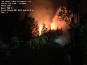
Low-level eruptive activity continues from a vent on the east flank of Pavlof Volcano, just below the summit. Volcanic tremor was observed in seismic data during the last 24 hours, but no explosions were detected. Elevated surface temperatures were seen in satellite images over the past day. Clear daytime web camera views showed a weak steam plume and recent mass flow and ash deposits extending from the active vent onto the upper flanks of the volcano. Incandescence at the vent was seen in nighttime webcam views.

Small explosions associated with the current eruption could happen at any time and may be accompanied by small ash plumes within the immediate vicinity of the volcano. The level of unrest at Pavlof Volcano can change quickly and the progression to more significant eruptive activity can occur with little or no warning.
Pavlof Volcano is monitored by local seismic and infrasound sensors, satellite data, web cameras, and regional infrasound and lightning networks.
Source : AVO
Photo : Jacob, Ben David .
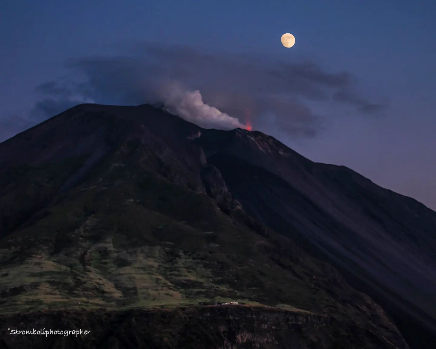
Italy , Stromboli :
WEEKLY BULLETIN, from November 07, 2022 to November 13, 2022, (issue date November 15, 2022)
ACTIVITY STATUS SUMMARY
In the light of the surveillance data, it is highlighted:
1) VOLCANOLOGICAL OBSERVATIONS: During this period, normal Strombolian-type explosive activity was observed with spattering activity in the North Crater area. The total hourly frequency oscillated between average values (11-14 events/h). The intensity of the explosions was low in the North crater area and low to medium in the South Center crater area.
2) SEISMOLOGY: The seismological parameters do not show any significant changes, except for the slight increase in the amplitude of the VLP signals from 11/11.
3) GROUND DEFORMATIONS: Tilt and GNSS station time series do not show significant variations
4) GEOCHEMISTRY: SO2 flux at an average level and moderately increasing.
CO2 fluxes in the crater area show a slight increase, remaining at medium-high values.
The weekly average of the CO2/SO2 ratio of Stromboli is equal to 4.4, but obtained only on a few measurements due to the unfavorable wind direction.
There are no updates on the isotope ratio of helium in groundwater.
5) SATELLITE OBSERVATIONS: The thermal activity observed by satellite in the summit area was weak.
VOLCANOLOGICAL OBSERVATIONS
In the period under observation, the eruptive activity of Stromboli was characterized by the analysis of the images recorded by the surveillance cameras of the INGV-OE at an altitude of 190 m (SCT-SCV), Punta dei Corvi and Pizzo , while the altitude camera 400 m due to video signal acquisition problems caused by damage to the optical fiber connecting Punta Labronzo and COA due to the bad weather that hit the island on August 12, 2022, does not is not available at the moment. The explosive activity was mainly produced by 4 (four) eruptive vents located in the North crater area and by 2 (two) vents located in the Center-South area. All the mouths are located inside the depression which occupies the terrace of the crater.
Observations of explosive activity captured by surveillance cameras:
Sector N1, with two emission points, located in the area of the North crater, produced low intensity explosions (less than 80 m high) emitting coarse materials (bombs and lapilli). Sector N2, with two emission points, showed mainly low-intensity explosive activity emitting coarse materials and continuous low-intensity spattering activity that became very intense on November 8 and 9. The average frequency of explosions varied from 4 to 7 events/h.
In the Center-South zone, no explosive activity was observed in sectors S1 and C, while in sector S2, with two emission points, explosive activity of low and sometimes medium intensity (less than 150 m from height) was highlighted, emitting coarse materials mixed with fine materials (ash). The average frequency of explosions varied between 5 and 9 events/h.
Source : INGV.
Photo : Stromboli Stati d’animo / Sebastiani Cannavo.
Kamchatka , Sheveluch :
VOLCANO OBSERVATORY NOTICE FOR AVIATION (VONA)
Issued: November 14 , 2022
Volcano: Sheveluch (CAVW #300270)
Current aviation colour code: ORANGE
Previous aviation colour code: orange
Source: KVERT
Notice Number: 2022-173
Volcano Location: N 56 deg 38 min E 161 deg 18 min
Area: Kamchatka, Russia
Summit Elevation: 3283 m (10768.24 ft), the dome elevation ~2500 m (8200 ft)

Volcanic Activity Summary:
A growth of the lava dome continues, a strong fumarole activity, an incandescence of the lava dome, explosions, and hot avalanches accompanies this process. Satellite and video data by KVERT shows an ash plume is extending for 15 km to the north-east of the volcano.
An extrusive eruption of the volcano continues. Ash explosions up to 10-15 km (32,800-49,200 ft) a.s.l. could occur at any time. Ongoing activity could affect international and low-flying aircraft.
Volcanic cloud height:
4500-5000 m (14760-16400 ft) AMSL Time and method of ash plume/cloud height determination: 20221114/0326Z – Video data
Other volcanic cloud information:
Distance of ash plume/cloud of the volcano: 15 km (9 mi)
Direction of drift of ash plume/cloud of the volcano: NE / azimuth 38 deg
Time and method of ash plume/cloud determination: 20221114/0326Z – Video data
Start time of explosion and how determined: 20221114/0320Z – Video data
Source : Kvert.
Photo : Yu. Demyanchuk, IVS FEB RAS, KVERT.
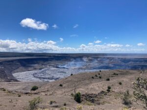
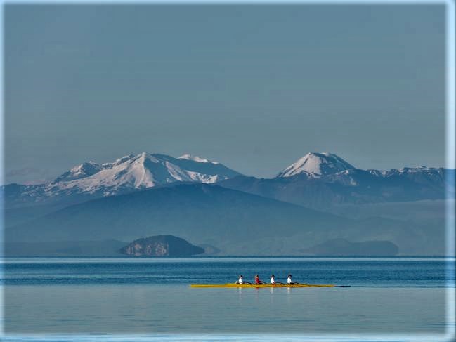
New Zealand , Lake Taupo :
Minor volcanic unrest continues at Taupō Volcano, as shown by continued small earthquakes and ground deformation.
The Volcanic Alert Level remains at 1 (minor volcanic unrest).
The earthquakes and deformation at Lake Taupō have continued since the last bulletin on 11 October 2022. The rate of earthquake activity has varied since the increase started in May. After a peak of about 30-40 events per week from June to September, the number of earthquakes dropped over the last month to about 10-12 per week. This has now risen again, over the last two weeks, to a little over 20 events per week. We have now located 840 earthquakes since the start of 2022, mainly at depths from 4 to 13 km beneath the centre of Lake Taupō. The earthquakes in the last 2 weeks, the largest of which was magnitude 3.6 on 4 November, have been concentrated in the central portion of the lake, south of Horomatangi Reef. Figure 1 shows the number of earthquakes detected beneath Lake Taupō each week since early 2022.
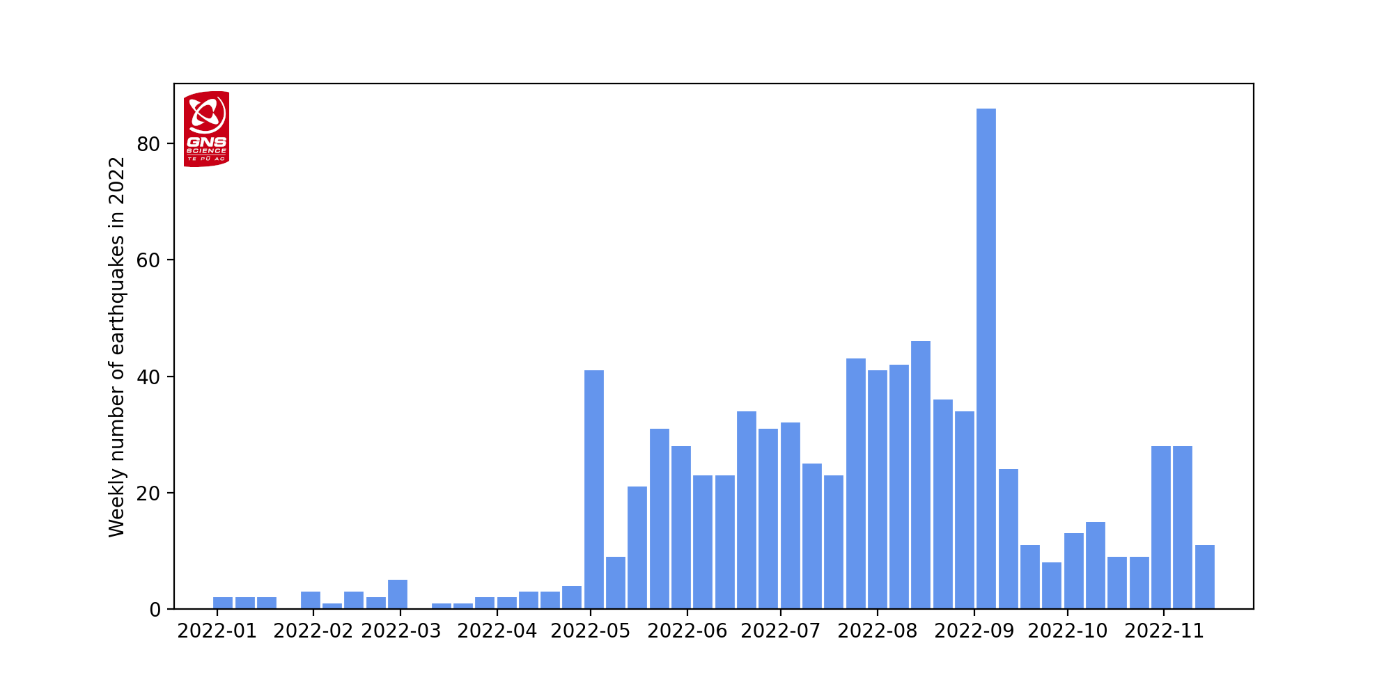
Figure 1 Number of earthquakes detected and located beneath Lake Taupō each week since the start of 2022.
In addition to seismic activity, we also continuously monitor ground deformation (land movement) around Lake Taupō. Our GNSS (GPS) instruments around the lake continue to observe both horizontal and vertical changes. A site on Horomatangi Reef in the centre of the lake indicates that uplift at a rate of approximately 60 ± 20 mm per year has continued since May 2022 (Figure 2).
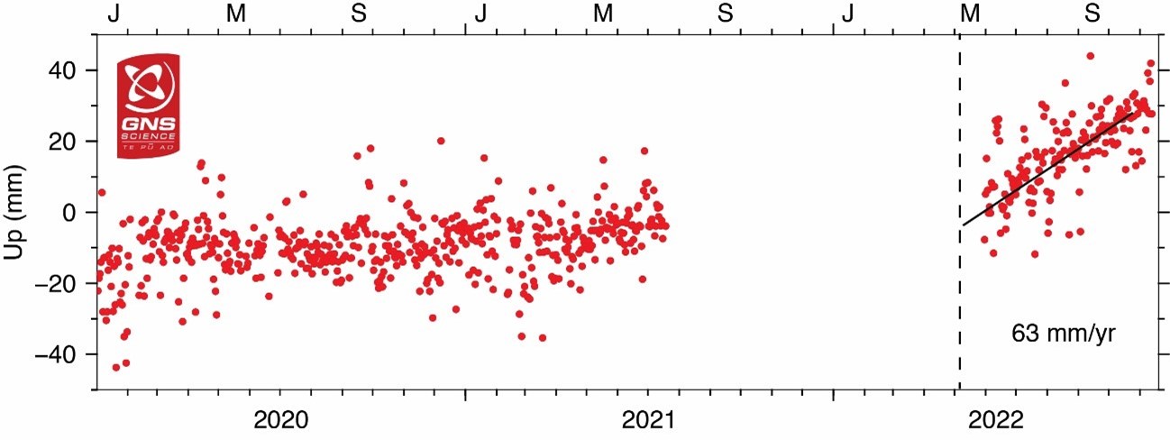
Figure 2: GNSS ground uplift observed at Horomatangi Reef in central Lake Taupō since 2020. The observations represent daily elevations. The scatter in the observations reflects the uncertainty in the calculated daily elevations. The GNSS site at Horomatangi Reef was not operating from mid-2021 to mid-2022.
We interpret the ground deformation and earthquake activity to be caused by activity associated with magma and hydrothermal fluids inside the volcano. This activity could continue for the coming weeks or months at varying rates or intensities. While some of the earthquakes have been felt in areas around Lake Taupō, the deformation is currently only detectable by our sensitive ground-based monitoring instruments.
In broad terms, such volcanic unrest occurs when magma or magma-heated hot water and steam moves deep within the ground beneath a volcano, changing the stresses there and producing earthquakes and ground movement. There have been 17 previous episodes of unrest at Taupō over the past 150 years and none have resulted in an eruption.
Source : Geonet
Photos : Geonet , Barekiwi .
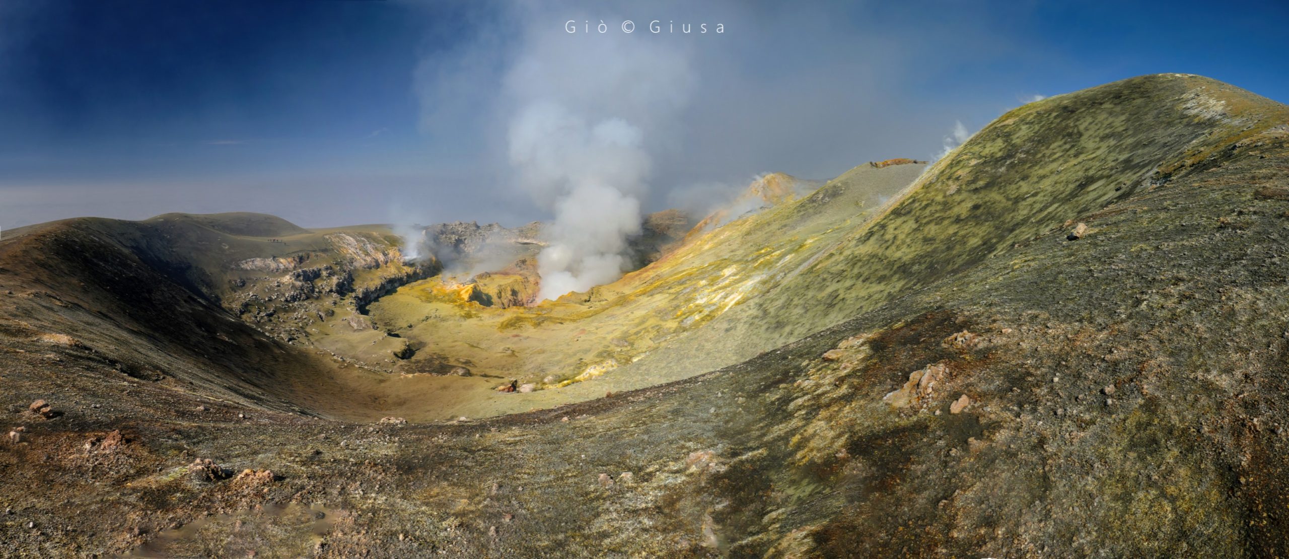
Chile , Copahue :
Special Report on Volcanic Activity (REAV), Biobío region, Copahue volcano, November 15, 2022, 5:15 p.m. local time (mainland Chile)
The National Geology and Mining Service of Chile (Sernageomin) announces the following preliminary information obtained through the monitoring equipment of the National Volcanic Monitoring Network (RNVV), processed and analyzed at the Observatory of the Volcanoes of the Southern Andes ( OVDAS), concerning the recent activity of the Copahue volcano:
Seismic monitoring: Since November 13 of this year, a gradual increase in the energy of the seismic signal linked to volcanic tremor can be observed, evaluated on the basis of the RSAM (Real Time Seismic Amplitude Measurement, for its acronym in English). Although during the year 2022 this value remained relatively stable and only with minor and punctual oscillations, the earthquake of magnitude MW 6.2 occurred near the city of Lebu (225 km west of the volcano) on Sunday, November 13 at 02:24:59 UTC (23:24:59 HL on November 12), could have caused magmatic disturbances. These became evident a few hours later with this increase in volcanic activity.
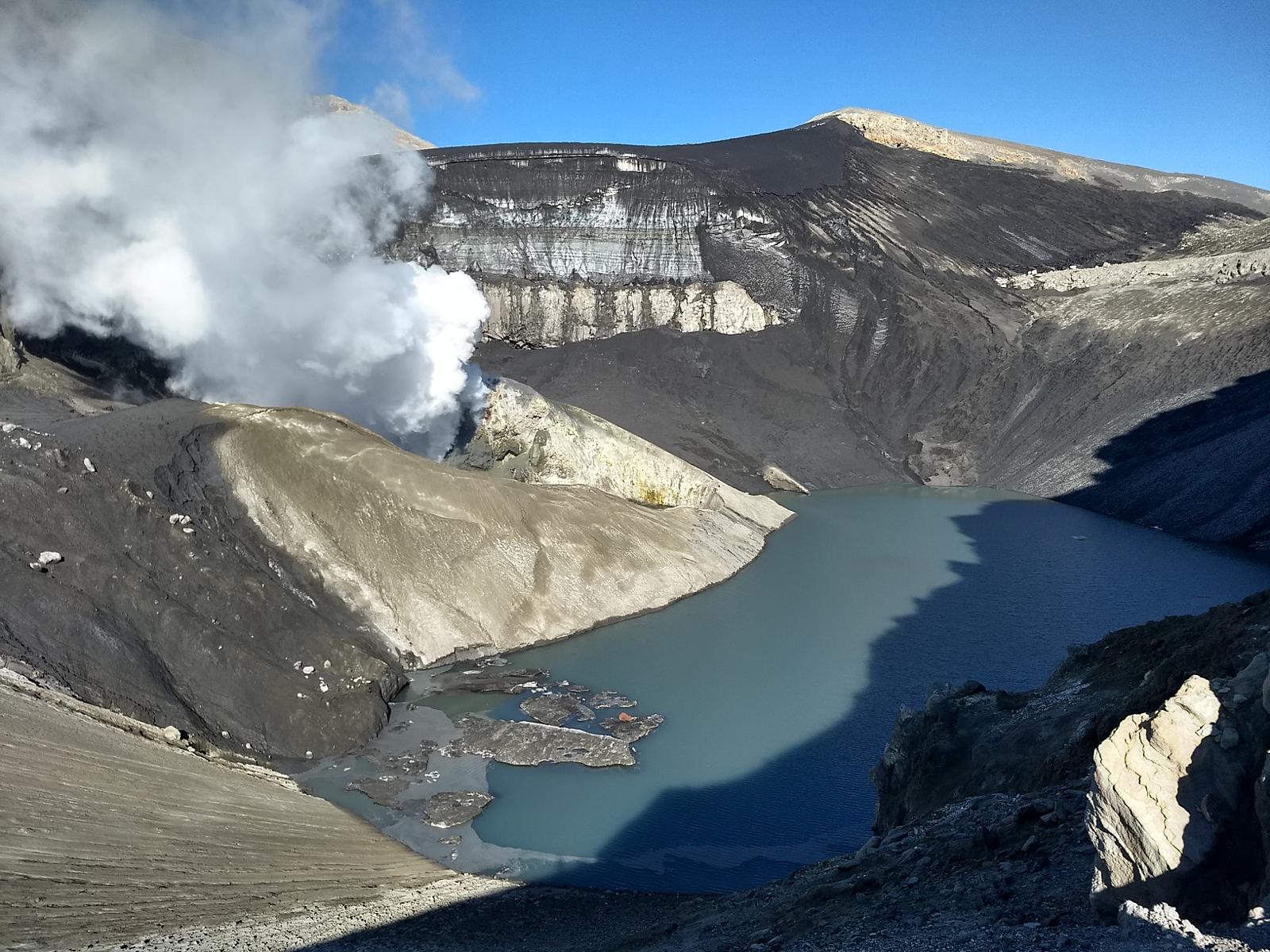
Surveillance by surveillance cameras: Although there are no images available due to the unfavorable weather conditions observed a few days ago, since November 15, the surface activity seen by the fixed cameras installed by Sernageomin , presented an increase compared to the last few weeks, testifying to a denser column of gas mainly white in color with heights reaching 200 m above the El Agrio crater.
The images provided on the site www.planet.com indicate the presence of an acid lake inside the crater El Agrio on the Copahue volcano, the absence of which at other times indicated the proximity of magmatic material to shallower levels. The other follow-up parameters remained stable during the last months of follow-up.
In summary, according to the information presented, and although a slight increase in seismic and surface activity is observed, particularly associated with volcanic tremor and degassing, there is no information that allows us to infer a destabilization of the system, therefore, it is maintained the current alert level. However, from what has been observed in recent years, minor explosive events and reactivations without major instrumental precursors and with limited impact on the surroundings of the volcano’s crater, could suddenly occur in this state of activity. A potential volcanic danger zone near the crater with a radius of 500 meters is preserved.
The volcanic technical alert remains at the Green level.
Source : Sernageomin .
Photo : Carpediem1971