March 03 , 2021 .
Italy / Sicily , Etna :
Communication on ETNA’s activity, March 02, 2021, 11:55 am (10:55 am UTC).
The National Institute of Geophysics and Volcanology, Osservatorio Etneo, reports that a resumption of weak Strombolian activity is observed at the Southeast Crater. From 10:45 UTC, there is a slight increase in the average amplitude of the volcanic tremor. Infrasound activity also shows an increase in the number of events.
Communication on ETNA’s activity, 02 March 2021, 12:46 (11:46 UTC).
The National Institute of Geophysics and Volcanology, Osservatorio Etneo, announces that from 11:34 GMT there is an increase in Strombolian activity at the Southeast Crater accompanied by the emission of ash which quickly disperse into the atmosphere . After a short stationary phase, the average amplitude of the volcanic tremor, around 11:30 GMT, began to increase again, the sources moving towards the Southeast Crater. At the same time, the rate of occurrence of infrasonic events is also increasing, and the sources are located in the Southeast Crater.
Communication on ETNA’s activity, 02 March 2021, 13:34 (12:34 UTC).
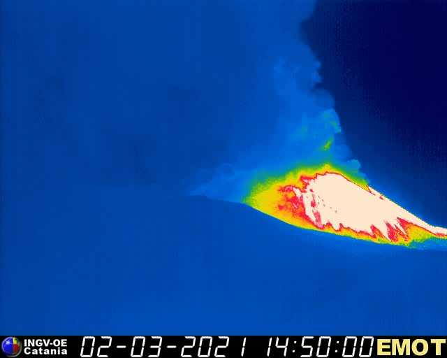
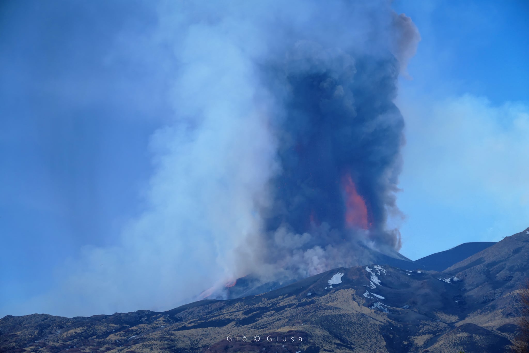
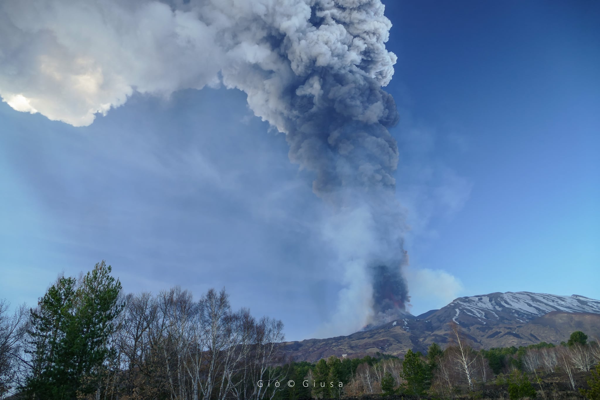
The National Institute of Geophysics and Volcanology, Osservatorio Etneo, reports that from 12:24 GMT a rapid increase in the amplitude of the volcanic tremor is observed, the source of which is located in correspondence with the Southeast Crater at about 3000 mr. Infrasound activity is also supported both in the rate of occurrence and in the energy of events. The location of infrasound events remains with the Southeast Crater. The Strombolian activity of the Southeast Crater has turned into a lava fountain. Due to the cloud cover, it is not possible to make continuous observations.
There are ash falls in the southern sector of the volcano. Particularly in the areas of: San Gregorio (motorway exit); Trecastagni; Aci S. Antonio; Pedara and Catania.
Communication on ETNA activity, 02 March 2021, 16:46 (15:46 UTC)
The National Institute of Geophysics and Volcanology, Osservatorio Etneo, announces that the activity of lava fountains at the Southeast Crater has ceased at 14:50 GMT. From 14:40 UTC, there was a rapid decrease in the average amplitude of the volcanic tremor which reached average values at 15:00 UTC. At the same time, the infrasound activity suffered a decrease. Analysis of the inclinometric data showed variations at different stations during the lava fountain episode, with maximum values (around 2 microradians) recorded at the Cratere del Piano (ECP) station. GNSS network data over the past few hours has shown fluctuations of a magnitude comparable to the measurement error.
There are therefore no significant changes.
Further updates will be communicated shortly.
Weekly bulletin, from February 22, 2021 to February 28, 2021 (issue date March 02, 2021)
SUMMARY OF THE STATE OF ACTIVITY
In the light of surveillance data, it is highlighted:
1) VOLCANOLOGICAL OBSERVATIONS: Paroxysmal episodes at the Southeast Crater, separated by intervals of relative calm; intracrater explosive activity and degassing of other summit craters
2) SEISMOLOGY: very low seismic fracturing activity; large and sudden variations in the amplitude of the tremor are correlated with the phases of volcanic activity.
3) INFRASONO: high infrasound activity
4) DEFORMATIONS: The GPS network did not record any significant changes during each of the three paroxysmal phases of the last week, but the medium-term analyzes confirm the deflationary tendency of the summit area which began in the first days of February.
Stations in the inclinometric network showed variations at all stations during the three paroxysmal phases, recording a maximum at the ECP station of about 3 microradians during the paroxysmal phase of February 28.
5) GEOCHEMISTRY: SO2 flow at a medium-low level
The CO2 flux from the soil remains at the mean degassing values.
The partial pressure of dissolved CO2 does not show significant changes.
No update is available for the C / S report.
The isotopic ratio of helium (partial results relating to the extraordinary sampling of 02/24/20201) is at medium-high values.
6) SATELLITE OBSERVATIONS: The thermal activity in the summit area is at a high level.
VOLCANOLOGICAL OBSERVATIONS
Etna’s activity during the week in question was observed through the network of visual and thermal surveillance cameras, and by INGV-OE personnel in the field on various occasions during and after the eruptive events.
During the week, there were three eruptive episodes produced by the Southeast crater characterized by a rapid evolution of the eruptive phenomenon and characterized by the passage of strombolian activity from one or more intra-crater vents, overflows of lava then followed by passages to lava fountains produced by the aggregation of unique active vents becoming a single jet of magma. The medium-length lava overflows (~ 2-4 km) mainly affected the east side with flows that spread into the Valle del Bove, and secondarily to the southern area near the Southeast crater. In some cases, pyroclastic flows in a southwest direction were also observed. The paroxysmal phenomenon produced eruptive columns that reached heights of up to 11 km above sea level, and, depending on the direction of the winds at high altitude, caused ash to fall in various sectors of the volcano.
(1) The paroxysm of February 22-23, 2021 was characterized by a lava fountain that lasted about 50 minutes, with an eruptive column more than 10 km high, the phenomenon lasted about 10 hours with an ash fall which affected the Northwest sector.
(2) The event of February 24, 2021 was characterized by an increase in Strombolian activity which from the end of the afternoon turned into a fountain at 8:00 p.m., preceded at 7:20 p.m. by an overflow of lava towards the Valle del Bove. The fountain lasted until 10:22 p.m., feeding jets up to about 500 meters high, an eruptive column up to about 11 km above sea level, a second flow to the southwest and around 10:00 p.m. a pyroclastic flow spread in the Valle del Bove for about 1 km. The total duration of the phenomenon was around 5 hours, while that of the fountain was around 2:20 am, causing ash to fall in a northwest direction.
(3) The climax of February 28, 2021 began at 8:10 a.m. with weak Strombolian activity that quickly shifted to a lava fountain at 8:39 a.m., feeding a flow to the Valle del Bove. The fountain suddenly intensified at around 9:09 am, with jets reaching about 700 meters above the crater and feeding an eruptive column up to 11 km above sea level. At 9:09 am, a small overflow begins to leave of the southern zone of the South-East crater which produces a pyroclastic flow at 09:20 a.m. The eruptive phenomenon of the fountain ends abruptly at 9:33 a.m., with a duration of the fountain of 54 minutes and a total phenomenology duration of 1:23. The fallout of ashes occurred to the east.
Source : INGV
Photos : ![]() Fabrizio Zuccarello , Gio Giusa ,
Fabrizio Zuccarello , Gio Giusa ,
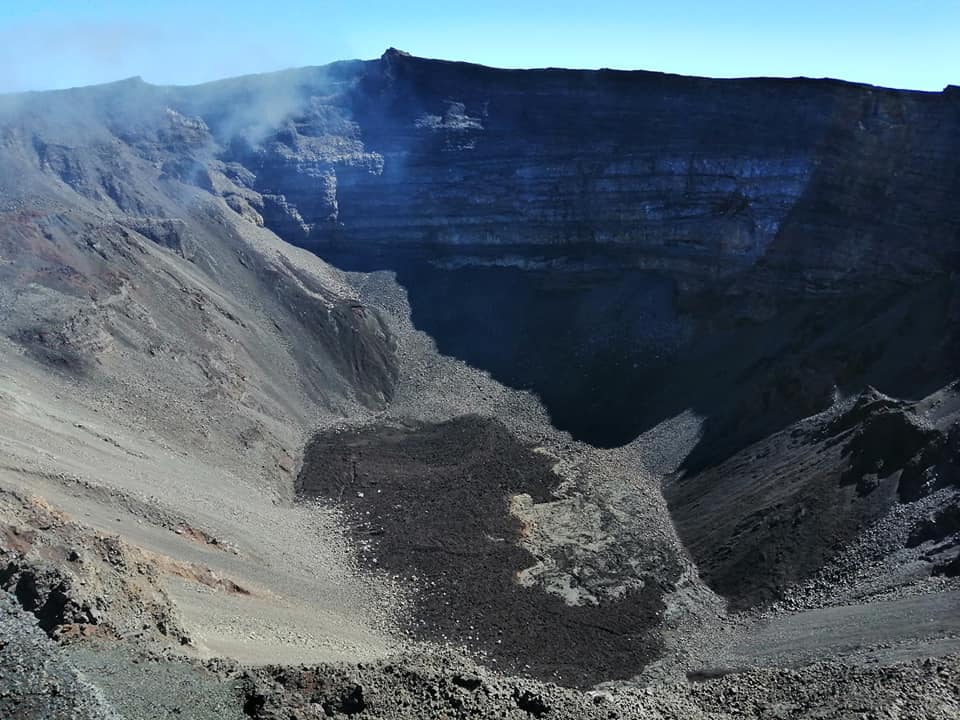
La Réunion , Piton de la Fournaise :
Seismicity
In February 2021, the OVPF recorded in the Piton de la Fournaise massif in total:
• 6 superficial volcano-tectonic earthquakes (0 to 2.5 km above sea level) under the summit craters;
• 1 deep earthquake (below sea level);
• 165 collapses (in the Dolomieu Crater, the ramparts of the Enclos Fouqué and Piton de Crac , and the East River).
The seismicity under the Piton de la Fournaise during the month of February 2021 remained low, with only 6 superficial volcano-tectonic earthquakes recorded under the summit zone and 1 deep earthquake.
Deformation
The inflation (swelling) of the building that had resumed following the eruption of December 7-8, 2020 stopped at the end of December 2020. Thus, during the month of February 2021, the GPS in the summit area and in the far field did not record any particular signals, with the exception of the GPNG and GPSG stations located in the Grandes Pentes area. Indeed the GPNG and GPSG stations have
continued to record subsidence and eastward movement, although their movement slowed. The GPSG station (south of the Grandes Pentes) sank about 22 cm and moved eastwards by about 18 cm between October 2019 and February 2021; and the GPNG station (North of the Great Slopes) sank about 12 cm and moved eastward by about
6 cm between October 2020 and February 2021.
Gas geochemistry
CO2 concentration in the soil.
In the far field (Plaine des Cafres and Plaine des Palmistes sectors): following the intrusion in September 2020, a new increase in CO2 emissions in the soil was recorded. The short-lived eruption of December 7-8, 2020 occurred during this escalation phase. Since the last eruption, a continuous increase in CO2 emissions from the soil is
recorded at the distal sites (Plaine des Cafres and Plaine des Palmistes sectors), but also proximal (Gîte du volcan ).
Source : OVPF.
Lire le rapport complet : https://www.ipgp.fr/sites/default/files/ovpf_20210301_bullmensu.pdf
Photo : Nath Duverlie
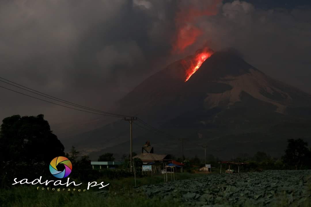
Indonesia , Sinabung :
The activity level has been at level III (SIAGA) since May 20, 2019 at 10:00 a.m. WIB. The Sinabung volcano (2460 m above sea level) has been erupting since 2013.
The volcano was clearly visible until it was covered in fog. The crater emits thick, white smoke with a height of about 100-500 meters above the summit. Hot avalanche clouds were observed with a sliding distance of 1000 to 3700 m to the east, south-east and 2300 m to the south. The weather is sunny to cloudy, with light to moderate winds in the Southeast, South and West. The air temperature is around 19-27 ° C.
According to the seismographs of March 02, 2021, it was recorded:
3 eruption earthquakes
173 avalanche earthquakes
15 hot cloud avalanche earthquake
19 emissions earthquakes
306 low frequency earthquakes
10 hybrid / multi-phase earthquakes
2 deep volcanic earthquakes
2 distant tectonic earthquakes
Continuous tremor of amplitude 2-6 mm, dominant value 3 mm
VONA: The last VONA message was sent with the color code ORANGE, published on March 2, 2021 at 08:40 WIB. Volcanic ash was observed 1000 m above the summit.
Source : PVMBG.
Photo : Sadrah ps.
United States , Mount Hood :
Short-lived burst of earthquakes occur at Mount Hood, March 1, 2021 . Release Date: MARCH 2, 2021
Burst-like swarms commonly interpreted to be caused by movement of hydrothermal fluids (water).
On March 1, 2021 at 12:13 p.m., an ~45-minute-long earthquake swarm occurred ~1 km (0.6 mi) southwest of Mount Hood’s summit at depths of 1-2 km (0.6-1.2 miles) below sea level (about 5-6 km (3-4 mi) below the summit). The Pacific Northwest Seismic Network located eight events so far with a maximum magnitude of M 1.3; dozens of other events were too small to locate. These earthquakes were too small to have been felt at the surface.

Although not a common occurrence, short-lived swarms have occurred near the summit in the past, including November 2013, September and October of 2014, and May 2016. Burst-like swarms of small earthquakes like this are considered to be a part of Mount Hood’s background seismicity. Such bursts of earthquakes are seen at many volcanoes around the world and in the Cascades, including at Mount Rainier, Mount St. Helens, and Lassen Peak (California), and are commonly interpreted to be caused by the movement of hydrothermal fluids (water).

Earthquakes from the swarm on March 1, 2021 are shown with red circles, while earthquakes from the January 2021 swarm are shown in blue. Earthquakes that have occurred since 2010 are shown as unfilled circles. All circles are sized by their magnitude. Top: Map view of seismicity at Mount Hood (Oregon). Black lines are roads, yellow circles are current seismic stations. The line between A and A’ is the cross section depicted below. Bottom: Cross-section of seismicity at Mount Hood. Symbols same as map view. The topography of Mount Hood is shown with the black line near the top of the plot.
While the seismicity represents a temporary uptick in activity, Mount Hood remains at normal, background levels.
Source : USGS/ CVO.
Photos : Pierson, Tom. USGS.