September 29 , 2022.
La Réunion , Piton de la Fournaise :
Press release, Paris Institute of Earth Physics, Piton de la Fournaise Volcanological Observatory, September 28, 2022 – 4:00 p.m. (local time) – 12:00 p.m. (UTC time).
Ongoing eruption
The eruption started on 09/19/2022 around 07:48 local time continues. The amplitude of the eruptive tremor (indicator of surface lava emission) has remained generally stable over the past 24 hours. It is however, slightly increasing compared to the previous days, at about 25% of its initial amplitude (Figure 1).
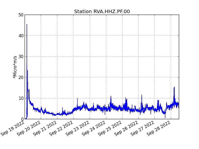
Evolution of the RSAM (indicator of a surface lava emission) since 09/19/2022 00:00 UTC time (04:00 local time) on the RVA seismological station located at the Rivals crater (© OVPF / IPGP).
– No volcano-tectonic earthquake has been recorded directly above the summit area over the past 24 hours.
– The resumption of a slight inflation (swelling) of the whole volcano (summit and enclosure) is confirmed.
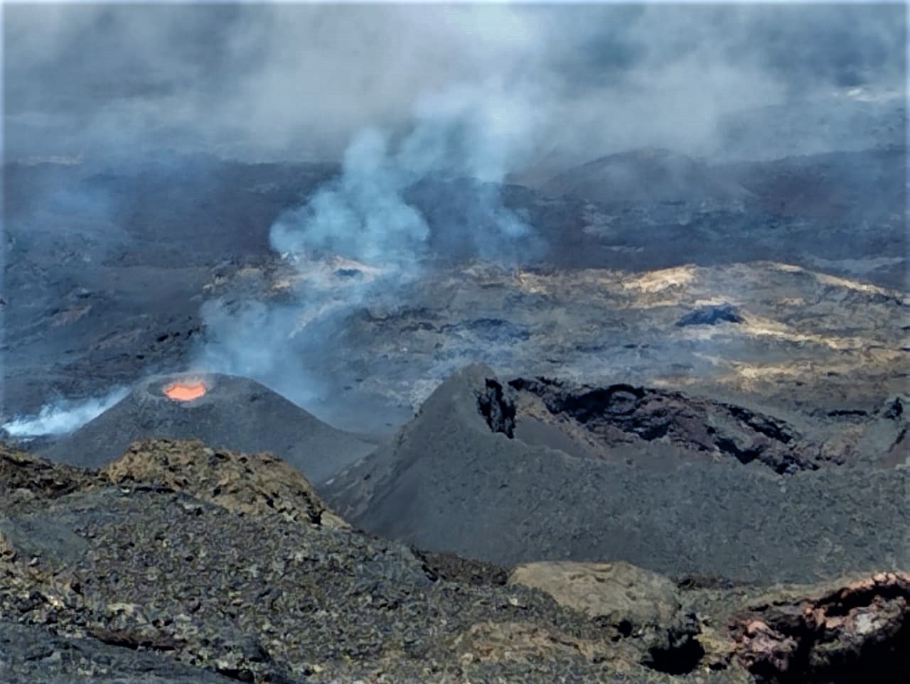
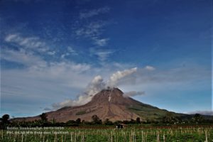
Shooting of the eruptive site on September 28, 2022 around 11:50 a.m. local time. On the left the cone in formation since the beginning of
the eruption on September 19, on the right the Kalla Pélé peak (August-October 2015 eruption) (©OVPF-IPGP).
The lava flow estimates established by satellite method on the HOTVOLC (OPGC – Clermont Auvergne University) and MIROVA (University of Turin) platforms indicate an average flow over the last 24 hours relatively stable and low around 3.5 m3/s with a peak maximum estimated at 7 m3/s.
The analyzes of sentinel-1 and ALOS satellite images carried out by the ISDeform platform show that:
– The positions of the fronts of the various flow arms have not changed since September 20, 23:56 local time (19:56 UTC),
– The contour of the lava flows did not change significantly between September 20 and 23,
– On the other hand, between September 23 and 27, the two main arms (East and South-East) widened.
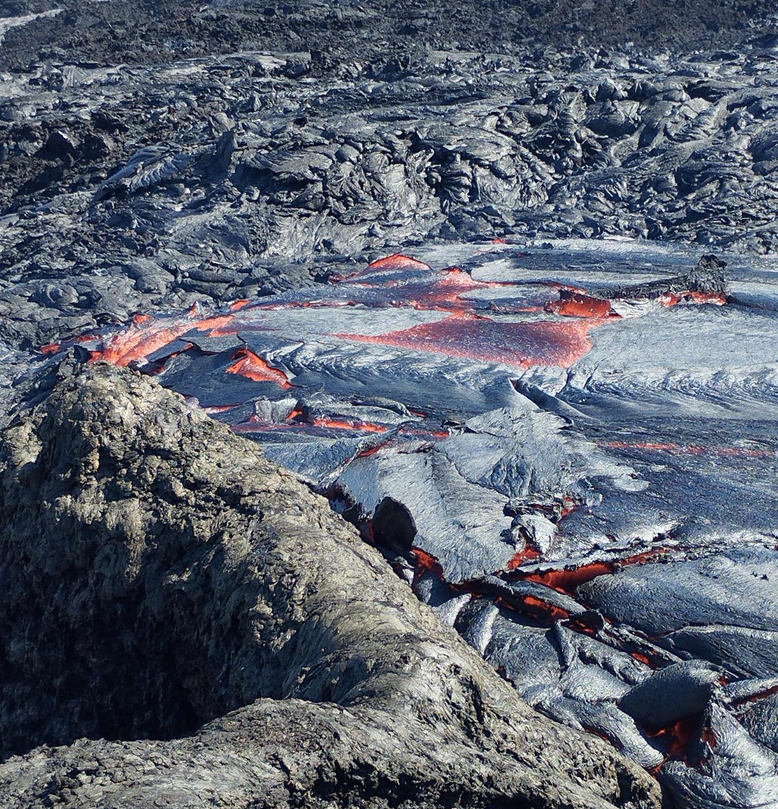
Lava flow shot on September 28, 2022 at 2:30 p.m. local time, showing the formation of corded lavas. (©OVPF-IPGP).
The observations of the OVPF-IPGP teams in the field show for today an activity similar to the previous days, namely:
– still significant degassing at the eruptive site and low amplitude lava projections;
– a gas plume still directed towards the West;
– a lava flow activity still mainly through lava tunnels;
– resurgences of lava visible at the level of the tunnels.
Alert level: Alert 2-1 (Access to the Enclosure prohibited; eruption in the Enclos without any particular threat to the safety of persons, property or the environment)
Source et photo : Direction OVPF / IPGP.
Italy , Vulcano :
WEEKLY BULLETIN, from September 19, 2022 to September 25, 2022, (issue date September 27, 2022)
ACTIVITY STATUS SUMMARY
In the light of the surveillance data, it is highlighted:
1) Temperature of the crater fumaroles: Along the upper edge, temperatures remain stable at high values.
2) CO2 flux in the crater area: The CO2 flux in the crater area remains stable at medium-high values.
3) SO2 flux in the crater area: stable SO2 flux at a moderately medium-high level
4) Geochemistry of fumarolic gases: The concentration of magmatic species (CO2, He, N2) is slightly decreasing (11 mol% CO2 on 09/14/2022).
5) CO2 fluxes at the base of the La Fossa cone and in the Vulcano Porto area: Continuous CO2 fluxes: stable CO2 flux values above the background noise of the Rimessa site; stable but still abnormal values on the Camping Sicilia site; slightly decreasing values at the Palizzi site (P4max); on the Faraglione site, the values recorded are stable and close to background noise.
Monthly CO2 Flux Campaign: CO2 emissions in the Vulcano Porto region show no significant change from the previous month and still remain at levels above background.
6) Geochemistry of thermal aquifers: consistently high temperature values and conductivity values at medium-low levels in the Camping Sicilia well; in the Bambara well, the level values increase sharply and the conductivity values decrease.
Monthly drilling campaign: a stabilization of the supply of fluids of fumarolic origin to the thermal aquifer is generally observed, which still remains at abnormal levels in certain sites for certain monitored parameters.
7) Local seismicity: Low occurrence rate of local micro-seismicity.
8) Regional seismicity: No earthquake with Ml >= 1.0 was located in the Vulcano region last week.
9) Deformations – GNSS: No significant variation is observed in the time series of the GNSS stations
10) Deformations – Inclinometry: No significant variation is observed in the inclination data
11) Gravimetry: The medium-long term variations are not obvious.
12) Other Notes: Mobile GNSS. The GNSS mobile network acquires and transmits movements in real time at a frequency of 1 Hz. The historical series acquired so far do not show significant variations around the Porto di Levante area.
CRATER FUMEROLES TEMPERATURE:
Along the upper edge, the maximum emission temperature has extremely stable values, with an hourly maximum of 383°C and a weekly average of 373°C (T1). The fumarolic field has homogeneous emission temperatures along the summit fracture line, confirming a thermal anomaly maintained by a stable vapor flux. The thermal signal from the FT3 sensor (fumerole F5) over the past week has overlapped with the temperatures recorded in FT1 (fumerole F5AT). It is necessary to organize the maintenance for the replacement of the buffer batteries, because we suffer from the constant loss of data at night.
Source : INGV.
Photo : INGV-Roma1
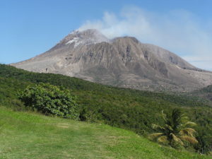
Japan , Sakurajima :
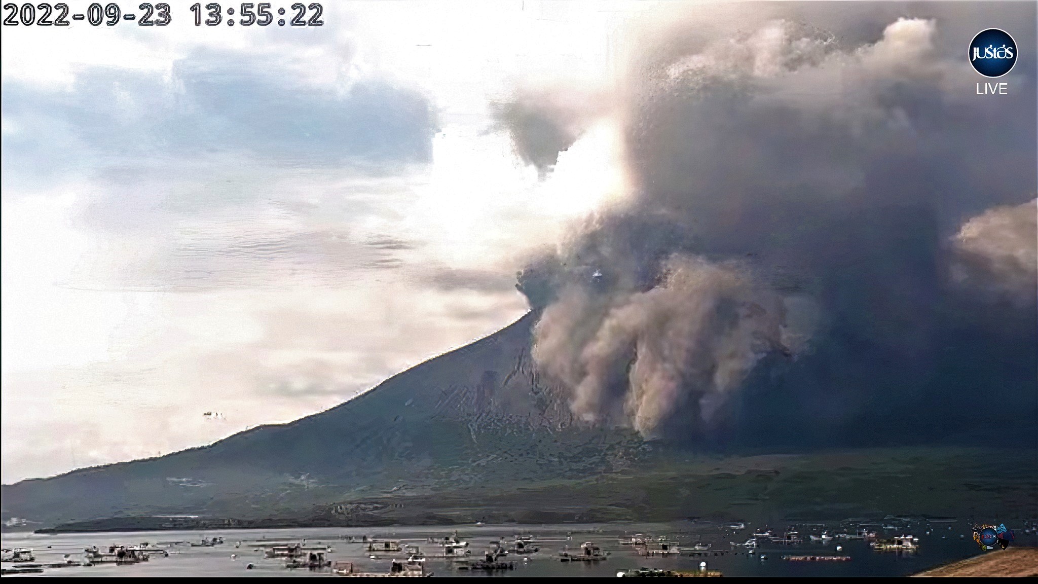
JMA reported that six eruptive events and three explosions at Minamidake Crater (at Aira Caldera’s Sakurajima volcano) were recorded during 19-26 September. Volcanic plumes rose as high as 2.4 km above the crater rim and large blocks were ejected as far as 700 m from the vent. Incandescence at the crater was visible nightly. Sulfur dioxide emissions were somewhat high at 1,900 tons per day on 22 September. Nighttime incandescence at the crater was visible during 2-16 September. A notable eruptive event at 13h35 on 23 September generated an ash plume that rose 1.7 km above the crater rim and also drifted down-flank to the SE until 16h00. A large amount of ashfall was deposited on the SE flank. The Alert Level remained at 3 (on a 5-level scale), and residents were warned to stay 2 km away from the crater.
The Aira caldera in the northern half of Kagoshima Bay contains the post-caldera Sakurajima volcano, one of Japan’s most active. Eruption of the voluminous Ito pyroclastic flow accompanied formation of the 17 x 23 km caldera about 22,000 years ago. The smaller Wakamiko caldera was formed during the early Holocene in the NE corner of the Aira caldera, along with several post-caldera cones. The construction of Sakurajima began about 13,000 years ago on the southern rim of Aira caldera and built an island that was finally joined to the Osumi Peninsula during the major explosive and effusive eruption of 1914. Activity at the Kitadake summit cone ended about 4850 years ago, after which eruptions took place at Minamidake. Frequent historical eruptions, recorded since the 8th century, have deposited ash on Kagoshima, one of Kyushu’s largest cities, located across Kagoshima Bay only 8 km from the summit. The largest historical eruption took place during 1471-76.
Source : GVP
Photo : Web cam via Isamu Kitafuji.
Tonga Islands , Home Reef :
The Tonga Geological Services reported that the new island at Home Reef that emerged from the ocean on 10 September continued to grow through 27 September. The eruption continued at variable intensities, mainly producing daily plumes of gas and steam that rose no higher than 2 km above sea level. During 00h40-02h50 on 25 September steam-and-ash plumes rose 2-4 km a.s.l. and drifted 30 km W, S, and SE. At 00h30 on 27 September an ash plume rose 6-8 km a.s.l. and drifted 25 km SSE. The island was surrounded by plumes of discolored water. Mariners were advised to stay 4 km away from the volcano.

The island as of Monday 19 September 2022, measured 211m North-South and 218m East-West with an approximate total surface area of 8.6 acres and an estimated height of 15 metres above sea level. There are no hazard alerts for residents in Vava’u and Ha’apai.
Tonga’s Geological Services who are issuing daily updates on the eruption, reported that the Aviation Alert level was lowered from Orange to Yellow on 27 September.
The TDS update on Home Reef Volcano No.16 (27 September) stated that the volcanic activities in the previous 24 hours was progressive with 21 volcanic events, one of which was ash eruption compared to 15 volcanic events in the prior 24 hours. There were a total of 36 volcanic events, one of which was volcanic ash event detected at 12:36am. This corresponded with the volcanic ash event captured in the satellite imagery at 12:30AM at a height up to 6-8km above sea level within 25km SSE of the vent.

An eruption of Home Reef in the Tonga Islands in March 1984 produced an island with an estimated size of 500 x 1,500 m and a height of 30-50 m. A plume to 12 km height was reported during the 1-5 March eruption and large amounts of floating pumice were later encountered by passing ships. This photo, taken on 23 March 1984, shows water discoloration surrounding the ephemeral island
TGS said the volcano activity poses low risk to the Vava’u and Ha’apai communities.
Home Reef is located 25 km southwest of Late Island, 22 km northeast of Lateiki (Metis Shoal) and 75 km northwest of Mo’unga’one Island at Latitude & Longitude 18.992°S & 174.775°W.
Source : GVP , matangitonga.to.
Photos : matangitonga.to , P.J.R. Shepherd (Royal New Zealand Air Force; courtesy of John Latter, DSIR, published in SEAN Bull., 1984).
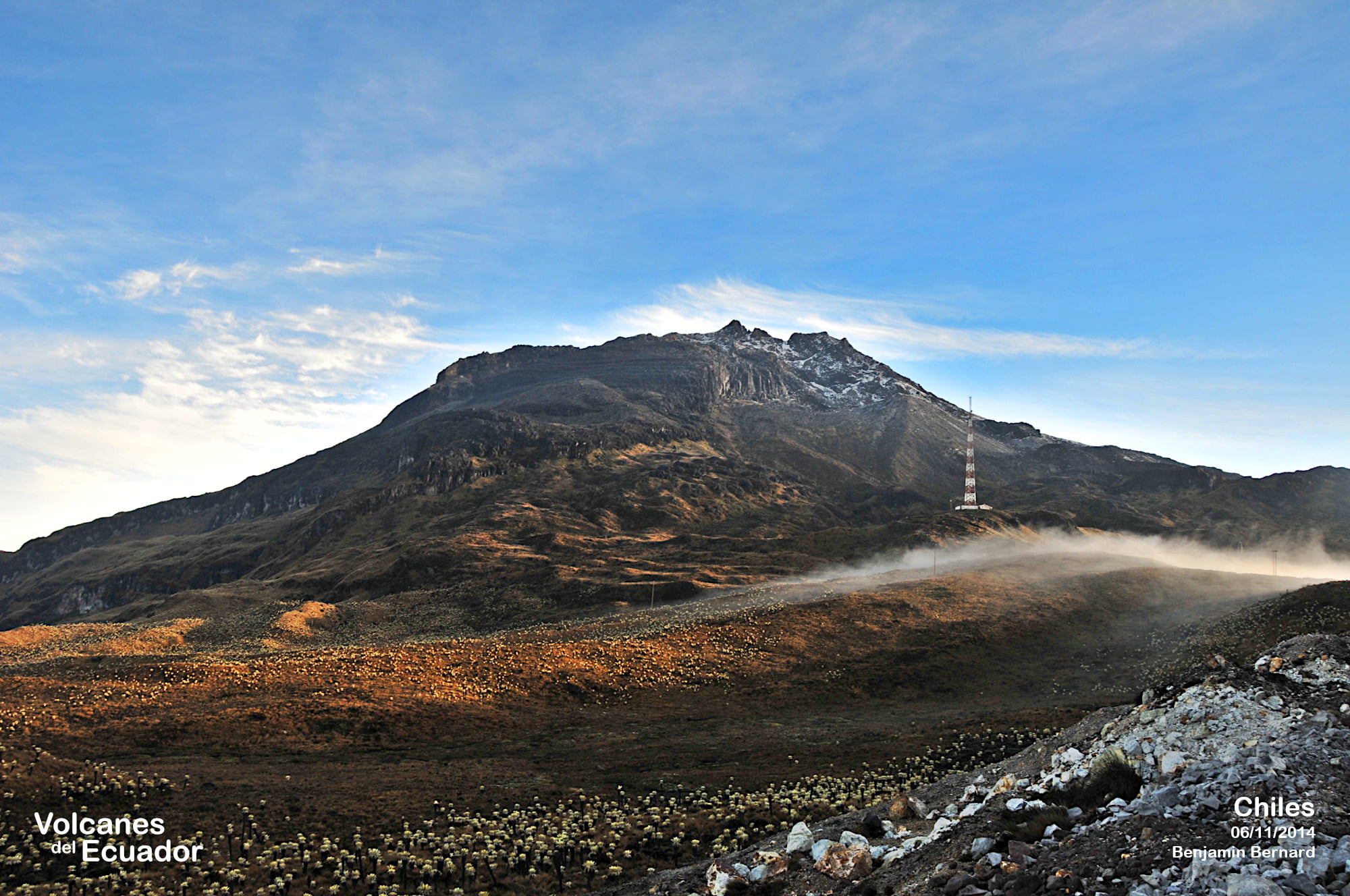
Colomba , Chiles / Cerro Negro :
Chiles and Cerro Negro volcanoes weekly activity bulletin
Volcano activity continues at YELLOW LEVEL ■ (III): CHANGES IN THE BEHAVIOR OF VOLCANIC ACTIVITY.
From monitoring the activity of VOLCANOES CHILES and CERRO NEGRO, the COLOMBIAN GEOLOGICAL SERVICE (SGC) reports that:
During the week evaluated, between September 20 and 26, 2022, the seismic activity of the volcanic complex maintained the downward trend, characteristic since mid-August 2022; decreasing both in the number of earthquakes recorded and in the seismic energy released. The internal processes of the volcano are mainly earthquakes associated with rock fractures located mainly to the south and southwest of the volcanic edifice of the Chiles volcano, at epicentral distances of up to 5.5 km, with depths less than 4.5 km from its summit (reference level 4700 m.) and a maximum magnitude of 2.4. The magnitude 2.4 event was recorded on September 23, at 8:38 a.m., and was not reported as felt by residents of the volcanic influence zone.
Few earthquakes were recorded towards the southeast sector of the Chiles volcano edifice, at distances between 7 and 10.5 km and depths between 8 and 10 km (reference level at 4700 m.); with low energy levels and a maximum magnitude of 1.2. These seismic manifestations are part of a process of ground deformation (observed instrumentally) which began at the end of March 2022 and continues to this day.
Based on the current behavior of this seismicity and what has been historically recorded in this active volcanic region, the possibility of more high-energy earthquakes, which may be felt by residents of the volcanic influence zone, n is not excluded.
Source : SGC.
Photo : Benjamin Bernard.