August 31 , 2022.
La Réunion , Piton de la Fournaise :
Press release, August 31, 2022 – 09:00 (local time) – 05:00 (UTC time)
Increased seismicity.
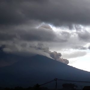
Since August 28, 2022 an increase in seismicity has been observed under the Piton de la Fournaise. Thus 20 volcano-tectonic earthquakes were recorded on August 28, 24 on August 29 and 41 on August 30. These low magnitude earthquakes (<1) are located under the Dolomieu crater between 1.5 and 2.5 km deep.
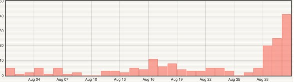
Histogram representing the number of superficial volcano-tectonic earthquakes recorded since August 1, 2022 (© OVPF-IPGP).
This seismicity follows more than 7 months of inflation (swelling) of the base and top of the Piton de la Fournaise building. This inflation is linked to a pressurization of the superficial magmatic reservoir located at about 1.5-2 km depth.
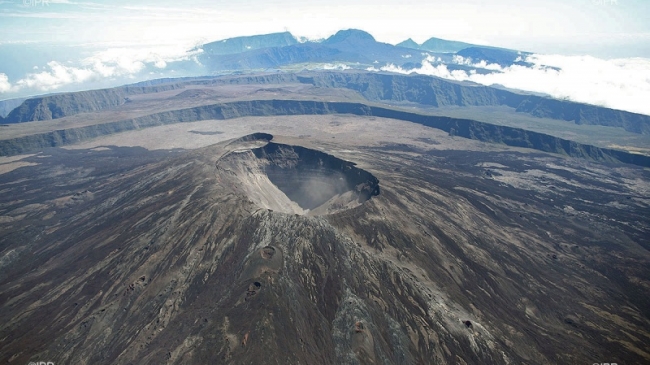
The appearance of seismicity at the roof of the reservoir shows that this pressurization process is intensifying. It should be noted that this process of recharging the superficial reservoir can last several days to several weeks before the roof of the reservoir weakens and does not rupture, thus giving rise to an injection of magma towards the surface and an eruption, but can also stop without giving rise – in the short term – to an eruption.
Alert level: Vigilance.
Source : OVPF
Photos : OVPF , IPR
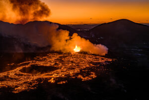
Italy , Stromboli :
WEEKLY BULLETIN, from August 22, 2022 to August 28, 2022. (issue date August 30, 2022)
ACTIVITY STATUS SUMMARY
In the light of the surveillance data, it is highlighted:
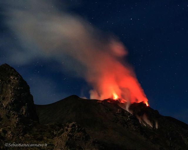
1) VOLCANOLOGICAL OBSERVATIONS: During the observation period, there is no update regarding the volcanological observations of Stromboli following problems with the acquisition of video signals caused by damage to the optical fiber connecting Punta Labronzo and COA. The latest updated data for the period from August 8 to 14, 2022, placed the total explosive activity at a medium-low level, with an intensity of explosions between low and medium in the areas of the North and Center-South craters .
2) SEISMOLOGY: The seismological parameters monitored do not show any significant variations.
3) GROUND DEFORMATIONS: During the period studied, the island’s ground deformation monitoring networks did not record any significant variations.
4) GEOCHEMISTRY: SO2 flux at an average level
The flux of CO2 from the soils in the summit zone is on average values.
The C/S ratio in the plume settles on average values
Isotope ratio of dissolved Helium in heat sinks: there is no update since the July 27, 2022 sampling.
5) SATELLITE OBSERVATIONS: The thermal activity observed by satellite in the summit area was weak.
VOLCANOLOGICAL NOTES
In the period under observation, there is no update regarding the volcanological observations of Stromboli, following problems in the acquisition of video signals caused by damage to the optical fiber connecting Punta Labronzo and COA due to the bad weather that hit the island on August 12, 2022. The latest updated data for the period from August 8 to August 14, 2022, placed the total explosive activity at a medium-low level, with the intensity of the explosions between low and average in the areas of the North and Center-South craters.
Source : INGV.
Photo : Sebastiano Cannavo / Stromboli Stati d’animo.
Russia / Kuril Islands , Ebeko :
VOLCANO OBSERVATORY NOTICE FOR AVIATION (VONA)
Issued: August 31 , 2022
Volcano: Ebeko (CAVW #290380)
Current aviation colour code: ORANGE
Previous aviation colour code: orange
Source: KVERT
Notice Number: 2022-96
Volcano Location: N 50 deg 41 min E 156 deg 0 min
Area: Northern Kuriles, Russia
Summit Elevation: 1156 m (3791.68 ft)
Volcanic Activity Summary:
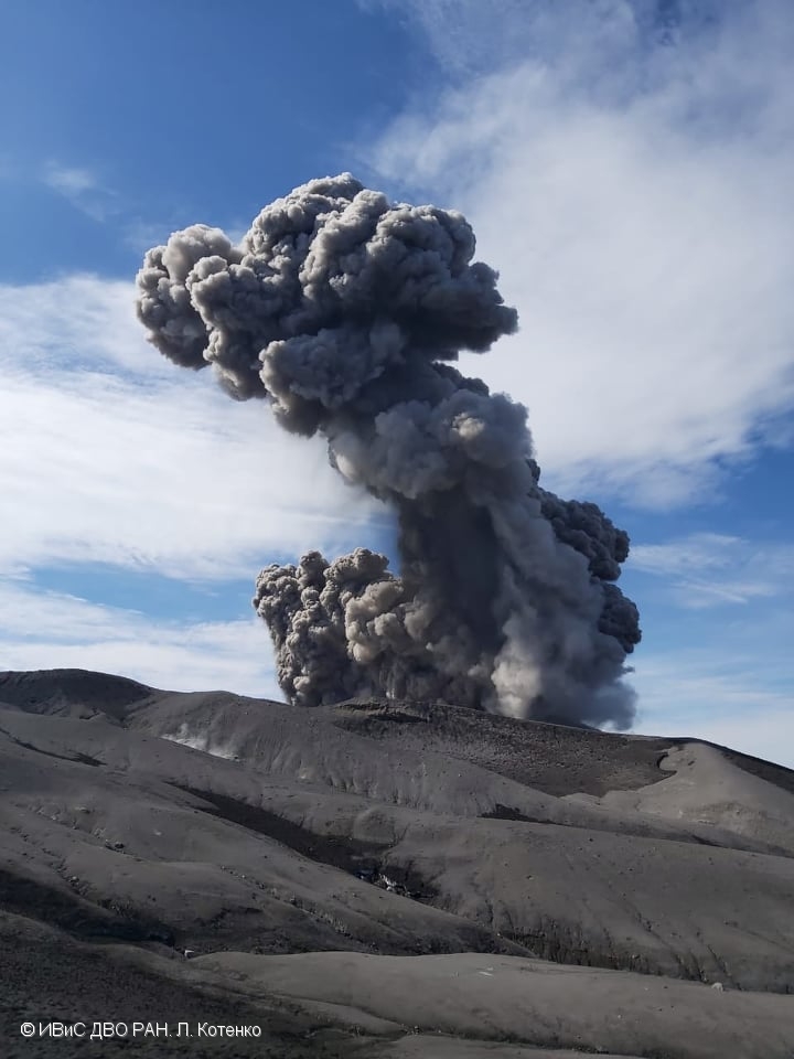
A moderate eruptive activity of the volcano continues. According to visual data by volcanologists from Severo-Kurilsk, an explosion sent ash up to 2.0 km a.s.l., an ash cloud is drifting to the north-east of the volcano.
A moderate eruptive activity of the volcano continues. Ash explosions up to 6 km (19,700 ft) a.s.l. could occur at any time. Ongoing activity could affect low-flying aircraft and airport of Severo-Kurilsk.
Volcanic cloud height:
2000 m (6560 ft) AMSL Time and method of ash plume/cloud height determination: 20220828/0502Z – Visual data
Other volcanic cloud information:
Distance of ash plume/cloud of the volcano: 5 km (3 mi)
Direction of drift of ash plume/cloud of the volcano: ENE / azimuth 70 deg
Time and method of ash plume/cloud determination: 20220828/0502Z – Visual data
Source : Kvert.
Photo : L. Kotenko. IVS FEB RAS
Italy , Vulcano :
WEEKLY BULLETIN, from August 22, 2022 to August 28, 2022. (issue date August 30, 2022)
ACTIVITY STATUS SUMMARY
In the light of the surveillance data, it is highlighted:
1) Temperature of the crater fumaroles: Along the upper edge, temperatures remain stable at high values.
2) CO2 flux in the crater area: The CO2 flux in the crater area remains stable at medium-high values.
3) SO2 flux in the crater area: SO2 flux at an average level
4) Geochemistry of fumarolic gases: No update is available.
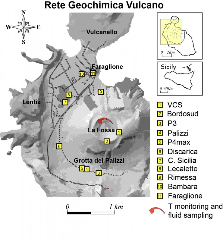
5) CO2 fluxes at the base of the La Fossa cone and in the Vulcano Porto area: CO2 flux values stable and above the background in the Rimessa site. There is a slight upward trend on the Camping Sicilia site; values reaching high levels at the Palizzi site. In the Faraglione site, stable values close to the background level.
6) Geochemistry of thermal aquifers: in the waters of the well of Camping Sicilia there are stable and always high temperature values and medium-low conductivity values; in the Bambara well, the level and conductivity values, which are at average values, have undergone sudden changes, attributable to intense rainfall events.
7) Local seismicity: low occurrence rate of local events.
8) Regional seismicity: Poor fracturing seismicity associated with earthquakes with Ml >= 1.0.
9) Deformations – GNSS: The network of permanent GNSS stations has not recorded any significant changes.
10) Deformations – Inclinometer: The inclinometer network did not register any significant changes
11) Gravimetry: No significant medium-long term variation was recorded.
12) Other Notes: Mobile GNSS. The GNSS mobile network acquires and transmits movements in real time at a frequency of 1 Hz. The historical series acquired so far do not show significant variations around the Porto di Levante area.
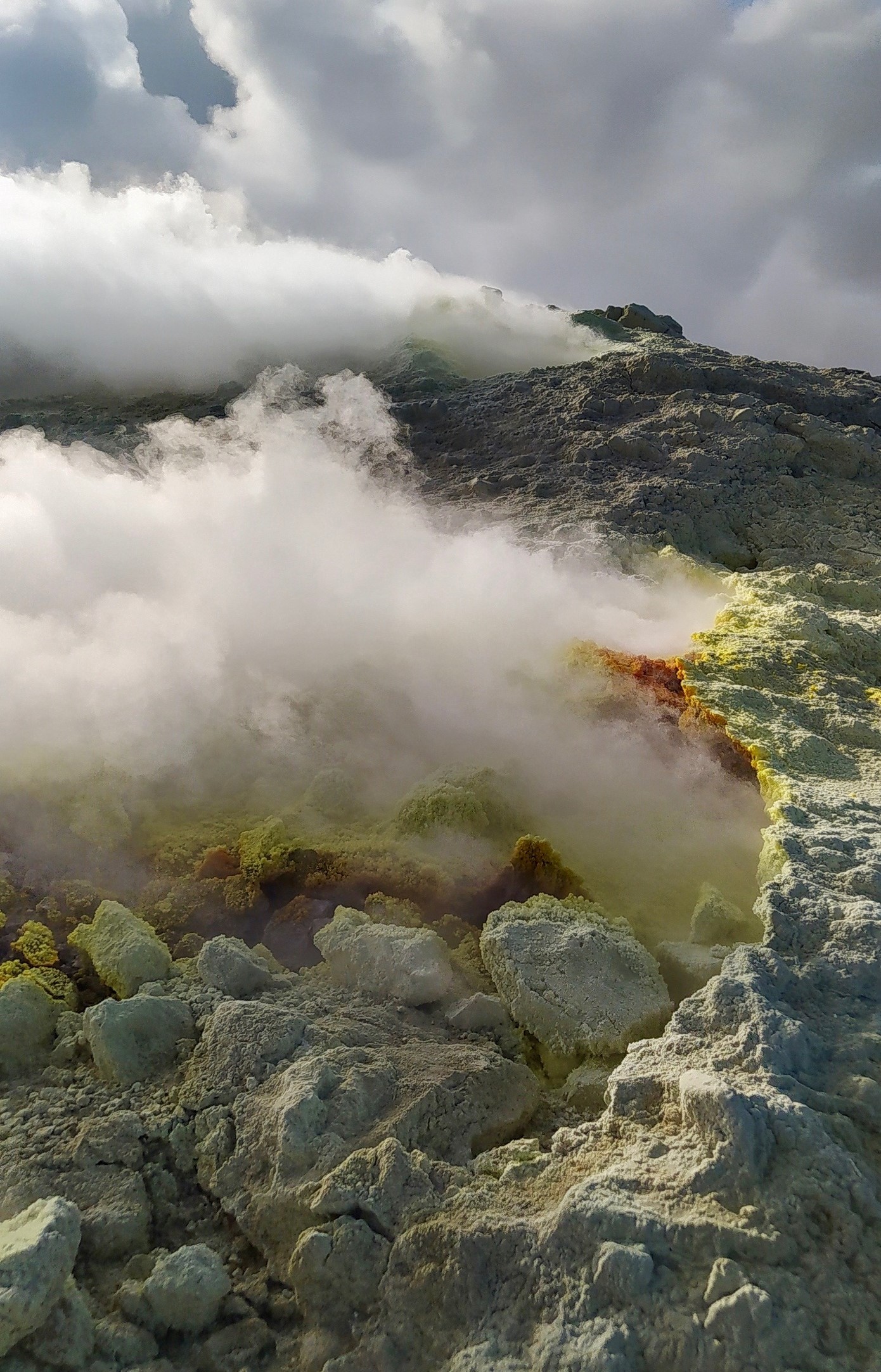
CRATER FUMEROLES TEMPERATURE:
Along the upper edge, the maximum emission temperature has extremely stable values, with an hourly maximum of 375°C and a weekly average of 373°C (T1). The fumarolic field has homogeneous emission temperatures along the summit fracture line, confirming a thermal anomaly maintained by a stable vapor flow. A rainy event disturbs the signal on the 24th at 7am, but in 4 days the monitored sites return to the reference temperatures. The thermal signal from the FT3 sensor (fumerole F5) over the past week has overlapped with the temperatures recorded in FT1 (fumerole F5AT). The inner side site showed a stationary trend (D temperature/D tempo = 0.0035°C/day) until a signal failure occurred.
Source : INGV.
Photos : INGV , G. De Astis (INGV-Rome1) .
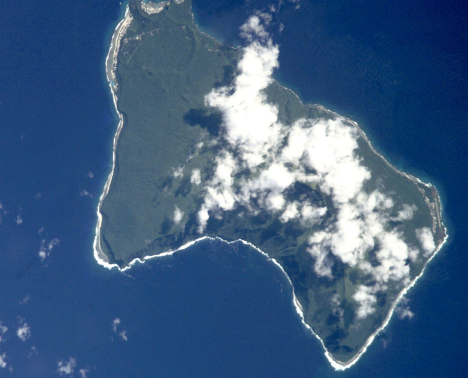
Samoa Islands , Ta’u :
14°13’48 » S 169°27’14 » W,
Summit Elevation 3054 ft (931 m)
Current Volcano Alert Level: ADVISORY
Current Aviation Color Code: YELLOW
The earthquake swarm related to Taʻū Island continues. Activity has not changed significantly since yesterday’s daily update. Data from the new seismometers confirms that the source location of earthquakes has not moved for many days. This tells us that the cause of the earthquakes has not shifted within the earth.
The American Samoa Emergency Operations Center did not receive any felt reports for the past 24 hours. However, the USGS seismic network detected at least 30 earthquakes that were large enough to be felt by people on the Manuʻa Islands. The largest event occurred at 12:56 AM SST today. There are many more small earthquakes that are undetectable by humans.
In the coming weeks, USGS staff will install Global Positioning System (GPS) receivers to improve the Manuʻa Islands’ monitoring network. The GPS equipment will detect very slight movements of the ground. As a result, GPS data will help us better understand what is happening beneath the ground and provide more accurate hazard assessments.
Source : HVO.
Photo : GVP.