August 31 , 2022.
Chile , Nevados de Chillan :
Special Report on Volcanic Activity (REAV), Ñuble Region, Nevados de Chillán Volcanic Complex, August 29, 2022, 11:08 a.m. local time (mainland Chile)
The National Geology and Mining Service of Chile (Sernageomin) publishes the following PRELIMINARY information, obtained through the monitoring equipment of the National Volcanic Monitoring Network (RNVV), processed and analyzed in the Volcanological Observatory of the Southern Andes (Ovdas) :
On Monday August 29, at 10:33 a.m. local time (14:33 UTC), the monitoring stations installed near the Nevados de Chillán volcanic complex recorded an earthquake associated with fluid dynamics inside the volcanic system (long period type) .
The characteristics of the earthquake after its analysis are as follows:
ORIGINAL TIME: 10:33 a.m. local time (2:33 p.m. UTC)
LATITUDE: 36.867°S
LONGITUDE: 71.370°W
DEPTH: 0.6 km
REDUCED DISPLACEMENT: 422 (cm2)
ACOUSTIC SIGNAL: 166.2 Pascals reduced to one km.

The characteristics of surface activity are as follows:
MAXIMUM HEIGHT OF THE COLUMN: 2000m above the point of emission.
DISPERSION DIRECTION: South
Observations:
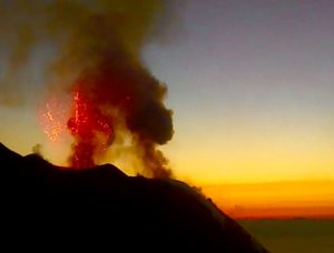
The explosion generated an eruptive column containing pyroclastic material that reached 2 km above the crater. In addition, the explosion was accompanied by pyroclastic flows from a distance of less than 500m in the east and south-east direction of the volcano.
Other seismic parameters prior to the reported event recorded low energy seismicity, related to fluid dynamics within the volcanic system.
The volcanic technical alert remains at the yellow level.
Source : Sernageomin.
Photo : Josefauna ( Archive).
Guatemala , Fuego :
Volcán de Fuego: the authorities declare themselves on alert because of the descent of lahars.
Due to heavy rains in the vicinity of the Fuego volcano, the descent of lahars has intensified, for which the authorities are on alert.
The heavy rains of the last hours favor the descent of lahars through the ravines that surround the Volcán de Fuego, which constitutes a risk for the inhabitants of the communities located on the slopes of the volcano, mainly in Escuintla, reported this Monday, August 29, the local authorities.
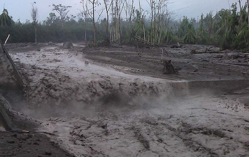
According to the National Coordinator for Disaster Prevention (Conred), a large amount of material descends from the upper part of the Volcán de Fuego through the ravines of Las Lajas, Trinidad and Ceniza. The authorities pointed out that this problem occurs every year in the sector due to the lack of road infrastructure, such as bridges, which is becoming one of the greatest needs of families residing in 10 communities in the sector.
The eruptions that the Volcán de Fuego has suffered in recent years, in particular the one that occurred in June 2018, caused millions of cubic meters of ash to flow through the ravines towards the bed of the Ceniza River, Achiguate, Guacalate , Pantaleón, Cristóbal, Coyolate and in recent months in Acomé and Río Seco.
For this reason, it is estimated that at least 200 communities in eight municipalities of Escuintla are at risk of flooding, and some of them could even be buried.
This extreme has happened before, because in October 2019, more than 20 houses in the El Socorro 5 housing estate, El Cajón, Santa Lucía Cotzumalguapa, were buried by lahars that descended the Pantaleón River.
Source : Prensalibre.com.
Photo : Caroline Sarrazin , Rés-EAUx .
Hawaii , Kilauea :
19°25’16 » N 155°17’13 » W,
Summit Elevation 4091 ft (1247 m)
Current Volcano Alert Level: WATCH
Current Aviation Color Code: ORANGE
Activity Summary:
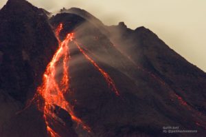
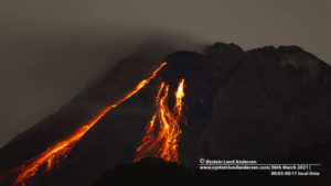
The summit eruption of Kīlauea Volcano, within Halemaʻumaʻu crater, continued over the past 24 hours. All recent eruptive activity has been confined to the crater. No significant changes have been observed at the summit or in either rift zone.
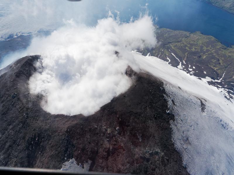
Halemaʻumaʻu Lava Lake Observations:
Eruption of lava from the western vent into the active lava lake and onto the crater floor continued over the past 24 hours. The active part of the lava lake showed continuous surface activity. Surface activity, outside the lava lake, occasionally occurs from breakouts along the margins of the crater. Overflight measurements from August 16, 2022, indicated that the crater floor had seen a total rise of about 137 meters (449 feet).

This overview photograph of the Halema‘uma‘u eruption at the summit of Kīlauea was captured by a HVO geologist in the morning of August 24, 2022, from the webcam site on the west rim of the crater. The active lava lake (silver) can be seen near the center-right of the frame, with substantial amounts of volcanic gas emitting from the nearby west vent that is feeding the eruption. The lava flows that constitute the remainder of the crater floor now stretch approximately 0.8 miles (1.3 kilometers) from west (near side) to east (far side). Two of the crater’s down-dropped blocks from the 2018 summit collapse are being overflowed at this time: one on the north side (left), and another on the west side (lower-right).
Summit Observations:
Summit tiltmeters recorded relatively little ground deformation over the past 24 hours. Volcanic tremor remains above background levels. A sulfur dioxide (SO2) emission rate of approximately 1,400 tonnes per day (t/d) was measured on August 26, 2022.
Rift Zone Observations:
No unusual activity has been noted along the East Rift Zone or Southwest Rift Zone; low rates of ground deformation and seismicity continue along both. Measurements from continuous gas monitoring stations downwind of Puʻuʻōʻō in the middle East Rift Zone remain below detection limits for SO2, indicating that SO2 emissions from Puʻuʻōʻō are negligible.
Source : HVO.
Photo : USGS / M. Zoeller.
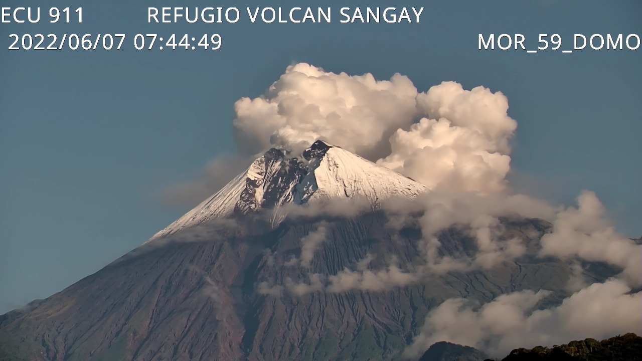
Ecuador , Sangay :
Monday 29 AUGUST 2022
Today, from around 4:00 p.m. TL, the SAGA seismic station records seismic signals corresponding to the descent of mudslides and debris (lahars) on the Sangay volcano. This phenomenon has been recurrent since the start of activity in May 2019 and is due to the fact that the rains in the volcano remobilize the abundant volcanic material accumulated in recent weeks. As a precautionary measure, it is recommended not to enter or approach the beds of the Sangay Norte, Culebrillas, Palora, Volcán and Upano rivers.
DAILY REPORT OF THE STATE OF SANGAY VOLCANO, Monday August 29, 2022.
Information Geophysical Institute – EPN.
Surface Activity Level: High, Surface Trend: No change.
Internal activity level: High, Internal trend: Ascending.
Seismicity: From August 28, 2022, 11:00 a.m. to August 29, 2022, 11:00 a.m.:
Due to technical problems in the reference station, the counting of events was carried out for a duration of 20 hours of operation.
Explosion (EXP) 461
Long Periods (LP) 22
Tremors (TRE) 45.
Rains / Lahars:
Heavy rains. **In the event of heavy rains, these could remobilize the accumulated materials, generating mudslides and debris that would descend on the flanks of the volcano and flow into the adjacent rivers.**
Emission / ash column:
No emission was observed by the cameras, due to the low visibility of the volcano sector. However, the Washington VAAC reported gas and ash emissions at heights of 870 and 1,170 meters above the summit, looking west.
Gas:
The MOUNTS system reported 70.9 tons of SO2, measured on 08/28/2022 at 13:52 TL.
Other Monitoring Parameters:
No thermal anomaly has been recorded in the last 24 hours.
Observation:
The volcano remained cloudy most of the time. No ash fall report was received.
Alert level: Orange.
Source : IGEPN.
Photo : ECU 911 ( archive)
Alaska , Cleveland :
52 49’20 » N 169 56’42 » W,
Summit Elevation 5676 ft (1730 m)
Current Volcano Alert Level: ADVISORY
Current Aviation Color Code: YELLOW
Unrest continues at Cleveland. Seismicity remains low. No explosive activity was detected on local or regional networks. No unusual activity observed in cloudy satellite views over the past day.
Episodes of lava effusion and explosions can occur without advance warning. Explosions from Cleveland are normally short duration and only present a hazard to aviation in the immediate vicinity of the volcano. Larger explosions that present a more widespread hazard to aviation are possible but are less likely and occur less frequently.
When operational, Cleveland volcano is monitored by only two seismic stations, which restricts AVO’s ability to precisely locate earthquakes and detect precursory unrest that may lead to an explosive eruption. Rapid detection of an ash-producing eruption may be possible using a combination of seismic, infrasound, lightning, and satellite data.
Source : AVO.
Photo : Herstand, Malcolm / Alaska Volcano Observatory / Alaska Division of Geological & Geophysical Surveys