February 25 , 2023.
Indonesia , Merapi :
Report on the activity of Mount Merapi from February 17, 2023 to February 23, 2023, Published on February 24, 2023
RESULTS OF OBSERVATIONS
Visual
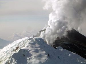
The weather around Mount Merapi is usually sunny in the morning and afternoon, while the evening is foggy. White smoke, thin to medium thickness, low pressure and 50 m high was observed from the Mount Merapi observation post of Ngepos on February 22, 2023 at 06:37 WIB.
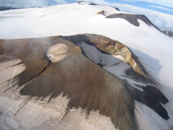
This week there were 11 southwestward lava avalanches (the main ones to Kali Bebeng then Kali Boyong) with a maximum slip distance of 1700m. The sound of avalanches was heard from Pos Babadan 4 times with low to medium intensity
On the Central dome and the South-West dome no significant change was observed. Based on aerial photos from January 13, 2023, the volume of the Southwest dome was measured at 1,598,700 m3 and the central dome at 2,267,400 m3.
Seismicity
This week, the seismicity of Mount Merapi showed:
596 Deep Volcanic Earthquakes (VTA),
338 avalanche earthquakes (RF),
3 emission earthquakes (DG),
7 tectonic earthquakes (TT).
25 multi-phase (MP) earthquakes
The intensity of this week’s seismicity is still quite high.
Deformation
The Mount Merapi deformation that was monitored using EDM and GPS this week showed a shortening rate of 0.6 cm/day.
Rain and lahars:
This week, there was rain with a rain intensity of 62 mm/h for 55 minutes in Pos Kaliurang on February 22, 2023. No increase in the flow of rivers descending from Mount Merapi was reported.
Conclusion
Based on the results of visual and instrumental observations, it is concluded that:
-The volcanic activity of Mount Merapi is still quite high in the form of effusive eruption activity. The state of the activity is defined at the « SIAGA » level.
Source : BPPTKG
Photo : Yohannes Tyas Galih Jati
Alaska , Takawangha :
51°52’1″ N 178°1’37 » W,
Summit Elevation 4754 ft (1449 m)
Current Volcano Alert Level: ADVISORY
Current Aviation Color Code: YELLOW
The ongoing earthquake swarm near Takawangha volcano continues, with more than 300 earthquakes located during the past week. The number of events per day was highest during the first half of the week, with seismic activity decreasing over the past several days. No eruptive signals were detected in seismic or satellite data. Weather conditions were mostly cloudy all week obscuring satellite views of the volcano.
Takawangha is monitored with a local seismic network, a single local infrasound sensor, regional infrasound and lightning sensors, and satellite imagery.
Takawangha is a remote, 1,449 m (4,754 ft)-high stratovolcano located on the northeast portion of Tanaga Island, roughly 95 km (59 miles) west of Adak in the Andreanof Islands. Takawangha’s summit is mostly ice-covered, except for four young craters that have erupted ash and lava flows in the last few thousand years. Parts of Takawangha’s edifice are hydrothermally altered and may be unstable, possibly leading to localized debris avalanches from its flanks. Takawangha lies across a saddle from historically active Tanaga volcano to the west. No historical eruptions are known from Takawangha; however, field work shows that recent eruptions have occurred and it is possible that historic eruptions attributed to Tanaga may instead have come from Takawangha.
Source : AVO
Photo : Coombs, M. L.
Colombia , Nevado del Ruiz :
Bulletin of activity level of the Nevado del Ruiz volcano.
The activity level continues at the yellow activity level or (III): changes in the behavior of volcanic activity.
Regarding the monitoring of the activity of the Nevado del Ruiz volcano, the COLOMBIAN GEOLOGICAL SERVICE reports that:
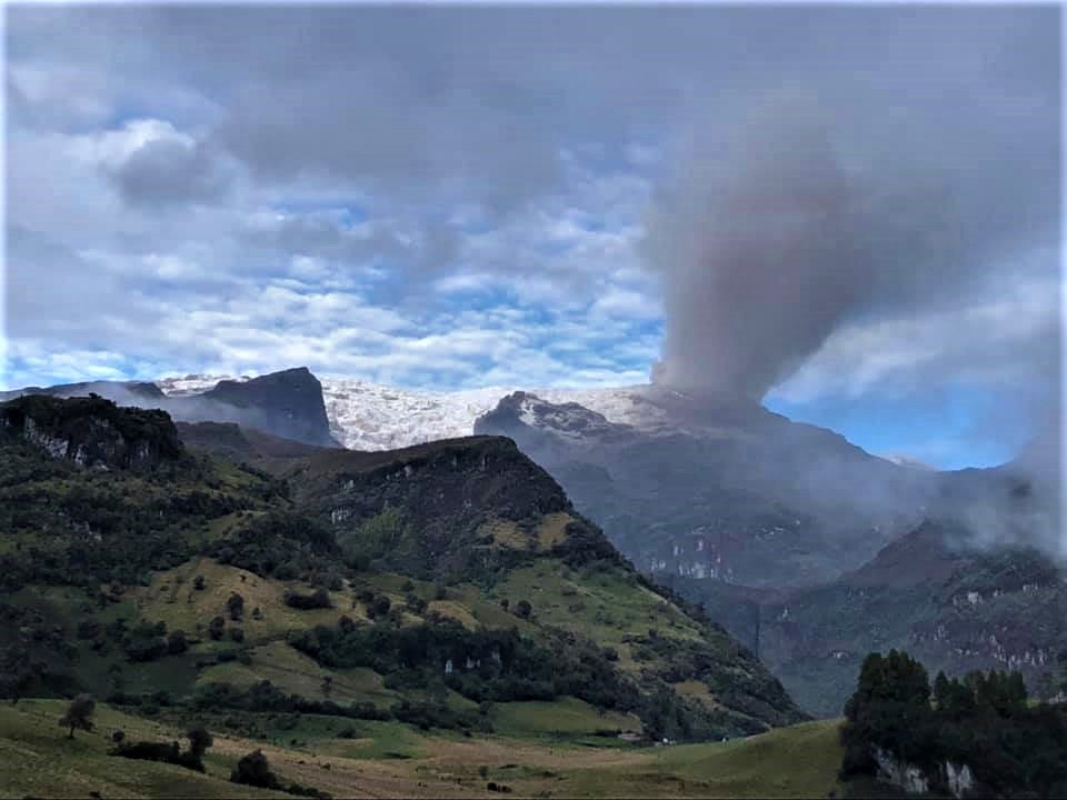
The seismic activity related to fluid dynamics inside the volcanic conduits decreased in the number of events recorded and in the seismic energy released compared to the previous week. According to images captured by cameras installed in the volcano area, several gas and ash emissions associated with some of the seismic signals have been confirmed. As a result of this superficial activity of the volcano, ash fell in the town of Manizales, Caldas.
Seismic activity associated with rock fracturing increased both in the number of earthquakes recorded and in the seismic energy released compared to the previous week. The earthquakes were located mainly in the South-West, West-South-West, North-East sectors and in the Arenas crater; with depths between 0.6 and 6.9 km. The occurrence of a seismic increase in this type of activity between February 18 and 19 stands out. The earthquakes were located 6.9 km west-southwest of the Arenas crater, at depths between 1.9 and 6.9 km. The maximum magnitude observed during this increase, and by ricochet during the week, was 1.6 ML (local magnitude) corresponding to the earthquake recorded on February 19 at 03:33 (local time), located 6.9 km the West-South-West of the Arenas crater, 4.4 kilometers deep.
Monitoring the volcano’s thermal activity, web portals have reported several low-energy thermal anomalies in Arenas Crater for this week.
Source : SGC.
Photo : Ramirez Jorge
Hawaii , Kilauea :
Friday, February 24, 2023, 8:54 AM HST (Friday, February 24, 2023, 18:54 UTC)
19°25’16 » N 155°17’13 » W,
Summit Elevation 4091 ft (1247 m)
Current Volcano Alert Level: WATCH
Current Aviation Color Code: ORANGE
Activity Summary:
The summit eruption of Kīlauea Volcano, within Halemaʻumaʻu crater, continues to be greatly diminished over the past 4 days. All recent eruptive activity has been confined to the crater. No significant changes have been observed in either rift zone.
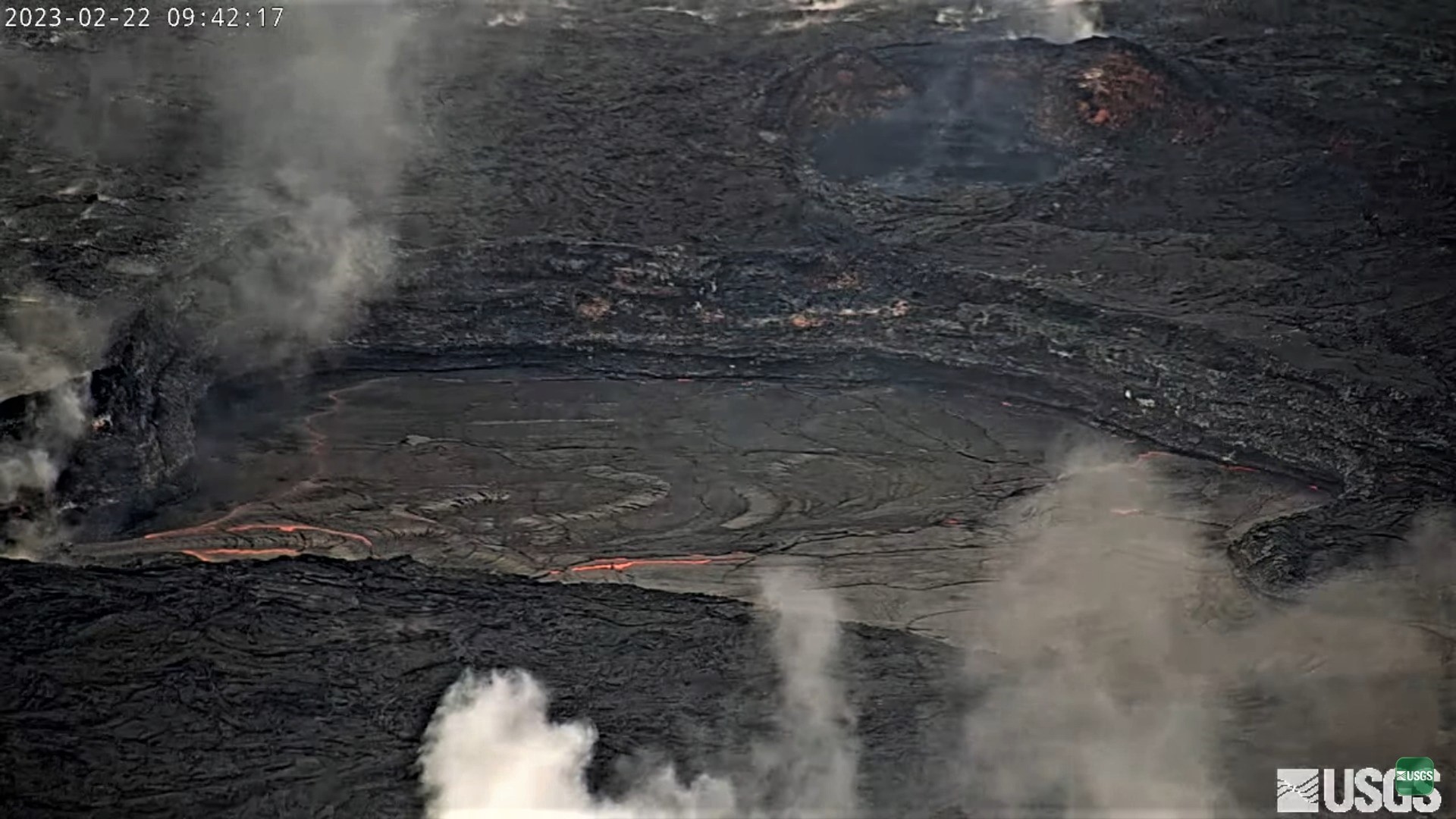
Halemaʻumaʻu crater Lava Lake Observations:
Eruption of lava on the Halemaʻumaʻu crater floor continues to be greatly diminished over the past 4 days. The eastern and central vents are not erupting. The western lake in the basin of the 2021–22 lava lake remains active but with weak lava flows. Very little lava is circulating within the lake, which is mostly crusted over with intermittent crustal overturns. The reduction in activity is related to the larger deflationary tilt drop that began in the early morning of February 17. Tilt is presently on a new inflationary trend over the past 24 hours. Surface eruptive activity is expected to resume when the summit re-inflates to the levels observed in the prior week.
Summit Observations:
Over the past 4 days summit tiltmeters showed small scale deflation/inflation cycles but have not returned to the levels seen prior to Feberuary 17th. Volcanic tremor has dropped slightly but remains above background levels. A sulfur dioxide (SO2) emission rate of approximately 2,000 tonnes per day (t/d) was measured on February 13, 2023.
Source : HVO.
Photo : USGS.
Guatemala , Santiaguito :
Weather conditions: Clear weather.
Wind: Northeast
Precipitation: 0.0 mm.
Activity:
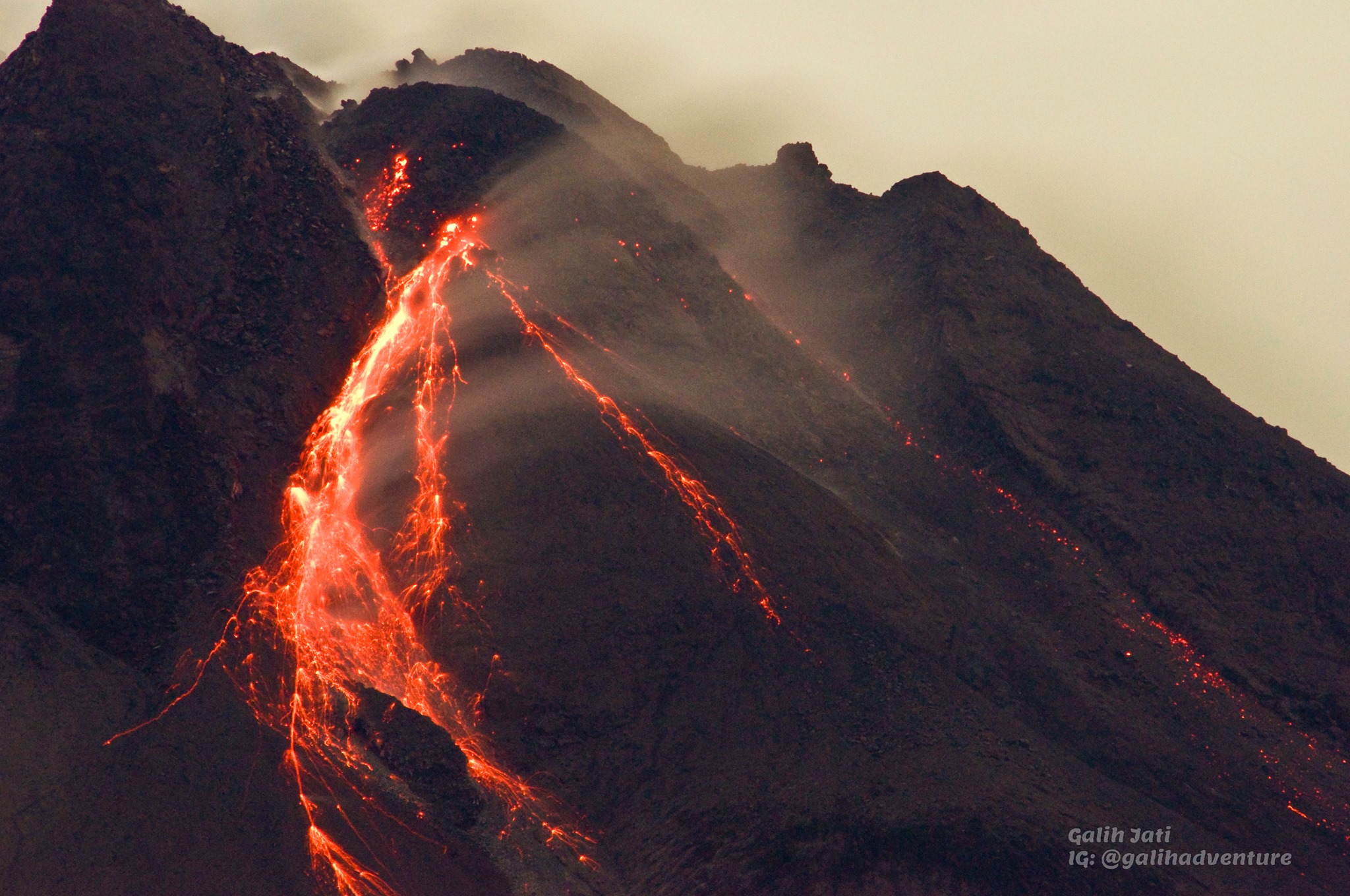
The observatory of the Santa María-Santiaguito volcanic complex reports activity in the Caliente dome with degassing that rises 400 meters above its dome, with nocturnal incandescence, weak explosions accompanied by audible rumblings in the farms neighbors, which raise columns of water vapor and ash 600 meters above the dome, as well as the descent of avalanches of incandescent materials towards the western, southern and southeastern flanks of the Caliente dome. Active lava flow activity in the Zanjón Seco and San Isidro channels continues with some boulder collapses, which generate ash clouds up to several hundred meters high.
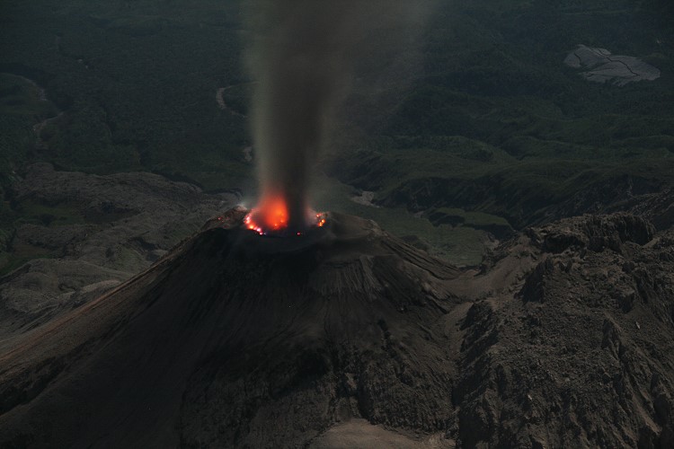
The explosions and these collapses keep the ash suspended in the environment around the domes, with the possibility of producing low ashfall on the farms of Monte Claro, El Faro and La Florida, Santa Marta and El Viejo Palmar. It is recommended not to approach the lava flow, due to the intense heat it gives off and the constant collapses that occur on its edges, which could cause burns and other serious injuries to those who come close. Extrusive activity remains at a high level and continues to pile material unstable in the lava flow, as well as in the cupola of the Caliente Dome, thus maintaining the possibility that some of this material will collapse and generates pyroclastic flows that can extend to the South-West, South and East.
Source : Insivumeh.
Photo : Marc Szeglat , 2009 , wikimedia