July 22 , 2022.
Hawaii , Kilauea :
19°25’16 » N 155°17’13 » W,
Summit Elevation 4091 ft (1247 m)
Current Volcano Alert Level: WATCH
Current Aviation Color Code: ORANGE
Activity Summary:
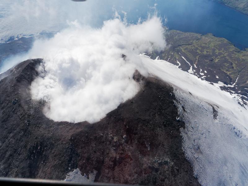
The summit eruption of Kīlauea Volcano, within Halemaʻumaʻu crater, has continued over the past 24 hours. All recent lava activity has been confined to the crater and current data indicate that this scenario is likely to continue. No significant changes have been noted at the summit or in either rift zone.
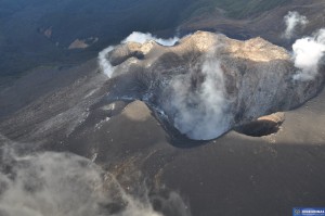
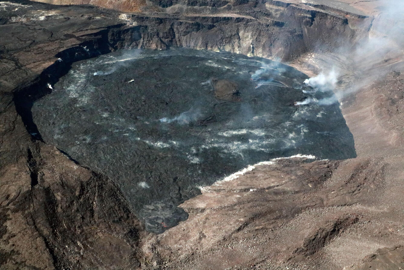
Hawaiian Volcano Observatory geologists captured this view of the caldera at Kīlauea summit during an overflight the morning of July 19, 2022. The active lava lake is visible within Halema‘uma‘u crater, the floor of which continues to slowly rise as the eruption continues. The former Hawaiian Volcano Observatory buildings can be seen in the lower center portion of the photo.
Summit Observations:
Eruption of lava from the Halemaʻumaʻu western vent into the active lava lake has continued over the past 24 hours. The lava level of the active lake surface remained at the level of the bounding levees. Ooze-outs were active along the southwestern edge of the crater floor around 9 am yesterday morning. Measurements from an overflight on July 19, 2022 indicated that the crater floor has risen about 133 meters (437 feet) total and that 98 million cubic meters (26 billion gallons) of lava has been effused since the beginning of this eruption on September 29, 2021. Summit tiltmeters have been steady over the last 24 hours. A sulfur dioxide (SO2) emission rate of approximately 1,700 tonnes per day (t/d) was measured on July 18, 2022. Summit tremor is steady for this eruption’s long term base-line level.
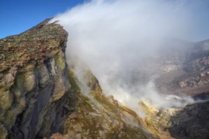
During a Hawaiian Volcano Observatory Kīlauea summit monitoring overflight on July 19, 2022, lava was oozing out the northern edge of Halema‘uma‘u crater floor. Incandescent lava is visible in this area, near the bottom center of this image, where lava is slowly encroaching on the large down-dropped block that formed during the 2018 caldera collapse.
Rift Zone Observations:
No unusual activity has been noted along the East Rift Zone or Southwest Rift Zone; steady rates of ground deformation and seismicity continue along both. Measurements from continuous gas monitoring stations downwind of Puʻuʻōʻō in the middle East Rift Zone remain below detection limits for SO2, indicating that SO2 emissions from Puʻuʻōʻō are negligible.
Source : HVO.
Photo : USGS / K. Mulliken , J. Chang.
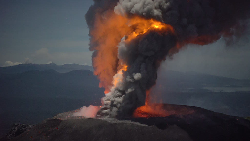
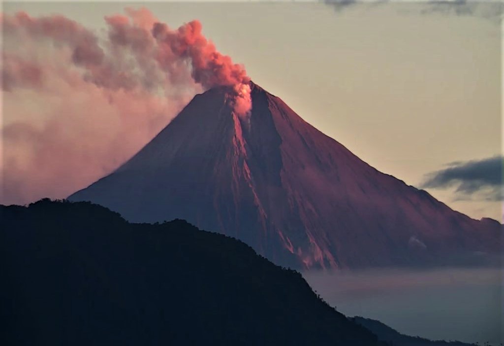
Indonesia , Ibu :
Mount Ibu erupted on Thursday, July 21, 2022 at 6:18 p.m. WIT with the height of the ash column observed at ± 800 m above the peak (± 2125 m above sea level). It is observed that the ash column is white / gray with a thick intensity oriented towards the West. This eruption was recorded on a seismograph with a maximum amplitude of 26 mm and a duration of 71 seconds.
VOLCANO OBSERVATORY NOTICE FOR AVIATION – VONA
Issued : July 21 , 2022.
Volcano : Ibu (268030)
Current Aviation Colour Code : ORANGE
Previous Aviation Colour Code : orange
Source : Ibu Volcano Observatory
Notice Number : 2022IBU43
Volcano Location : N 01 deg 29 min 17 sec E 127 deg 37 min 48 sec
Area : North Maluku, Indonesia
Summit Elevation : 4240 FT (1325 M)
Volcanic Activity Summary :
Eruption with volcanic ash cloud at 09h18 UTC (18h18 local).
Volcanic Cloud Height :
Best estimate of ash-cloud top is around 6800 FT (2125 M) above sea level, may be higher than what can be observed clearly. Source of height data: ground observer.
Other Volcanic Cloud Information :
Ash-cloud moving to west.
Source : Magma Indonésie.
Photo : Martin Rietze .
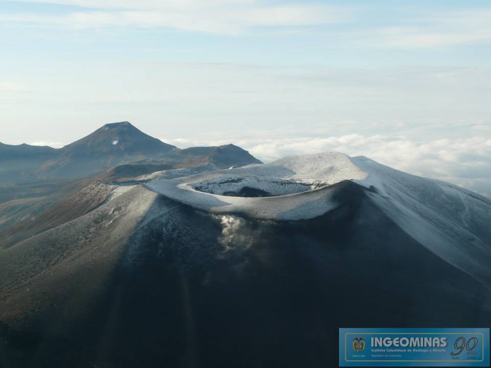
Colombia , Puracé – Los Coconucos Volcanic Range :
Weekly activity bulletin of Volcan Puracé – Los Coconucos volcanic chain.
The activity level of the volcano continues at the Yellow activity level or (III): changes in the behavior of volcanic activity.
From the analysis and evaluation of the information obtained through the monitoring network of the Puracé volcano – Los Coconucos volcanic chain, during the week of July 12 to 18, 2022, the COLOMBIAN GEOLOGICAL SERVICE – Volcanological and Seismological Observatory of Popayan reports that:
During this week, the strong occurrence of earthquakes associated with the movement of fluids inside the volcano continues. A total of 444 seismic events were presented, of which 44 were associated with rock fracturing processes (type VT) and 400 with fluid dynamics in volcanic conduits; of these, 350 were classified as long duration events (type LP), 14 were associated with both failure mechanisms and fluid dynamics and were classified as hybrid (type HB), 9 were classified as low frequency events (BF type), 4 as « tornillos » type earthquakes (TO type) and 23 as low energy tremor pulses (TR type).
The geodetic network of GNSS (Global Navigation Satellite System) ground deformation monitoring stations continues to record an associated process
to inflation.
On the surface activity monitoring, the images obtained during the week thanks to the Anambío, Mina, Lavas Rojas and Cerro Sombrero web cameras showed degassing of the volcanic system, with a white column oriented preferentially towards the North-West. .
Sensors monitoring magnetic and electric fields and infrasonic waves did not record variations associated with changes in volcanic activity.
Source : SGC.
Photo : Ingeominas.
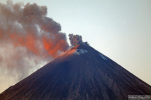
Ecuador , Sangay :
Information on the activity of the SANGAY Nº 2022-057 volcano, Quito, Thursday July 21, 2022.
Around 8:00 p.m. (TL), the SAGA seismic station records a new increase in the tremor signal. Similarly, ECU 911 cameras and satellite images (GOES-16) show that the activity associated with the ash column is sustained and has slightly increased in intensity, heading west. Therefore, the probability of ash fall in the areas surrounding the volcano remains (for example, the Center-South zone of the province of Chimborazo: Guamote, Cebadas). IG-EPN continues to follow the evolution of this event which is part of the current eruptive period of the Sangay volcano, which began in May 2019.
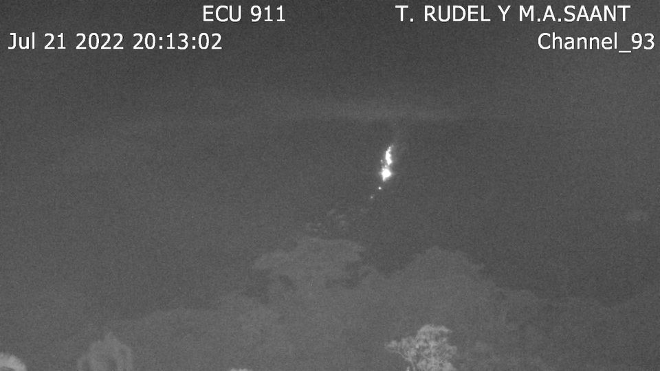
Photo: Ecu 911 camera. Expulsion and rolling of incandescent blocks along the southeast flank of the volcano. July 21, 2022, 8:13 p.m. TL.
The Geophysical Institute is monitoring and any news will be reported.
DAILY REPORT OF THE STATE OF SANGAY VOLCANO, Wednesday July 20, 2022.
Information Geophysical Institute – EPN.
Surface Activity Level: High, Surface Trend: No change.
Internal activity level: High, Internal trend: No change.
Seismicity: From July 19, 2022, 11:00 a.m. to July 20, 2022, 11:00 a.m.:
Due to technical problems in the reference station, the counting of events has been affected.
Explosion (EXP) 85
Long Periods (LP)38
Emission Tremors (TREMI ) 13.
Lahars (LH): 3.
Rains / Lahars:
Light rain was recorded using the Windy app, which generated small seismic signals associated with the descent of muddy water. **In the event of heavy rains, these could remobilize the accumulated materials, generating mudslides and debris that would descend on the flanks of the volcano and flow into the adjacent rivers.**
Emission / ash column:
Gas and ash emissions were observed up to 2000 meters above the level of the crater in a west-northwest direction. The Washington VAAC reported gas and ash emissions up to 1,170 meters above the crater in a westerly direction.
Other Monitoring Parameters:
FIRMS records 1 thermal alert in the last 24 hours.
Observation:
The volcano remained cloudy, there are no direct observations towards the crater.
Alert level: Orange.
Source et photos : IGEPN.
Alaska , Cleveland :
52 49’20 » N 169 56’42 » W,
Summit Elevation 5676 ft (1730 m)
Current Volcano Alert Level: ADVISORY
Current Aviation Color Code: YELLOW
Unrest continues at Cleveland. No significant activity was detected on local or regional seismic and infrasound networks. Satellite views of the volcano were obscured by clouds.
Episodes of lava effusion and explosions can occur without advance warning. Explosions from Cleveland are normally short duration and only present a hazard to aviation in the immediate vicinity of the volcano. Larger explosions that present a more widespread hazard to aviation are possible but are less likely and occur less frequently.
When operational, Cleveland volcano is monitored by only two seismic stations, which restricts AVO’s ability to precisely locate earthquakes and detect precursory unrest that may lead to an explosive eruption. Rapid detection of an ash-producing eruption may be possible using a combination of seismic, infrasound, lightning, and satellite data.
Source : AVO
Photo : Herstand, Malcolm / Alaska Volcano Observatory / Alaska Division of Geological & Geophysical Surveys