July 09 , 2022.
Indonesia , Merapi :
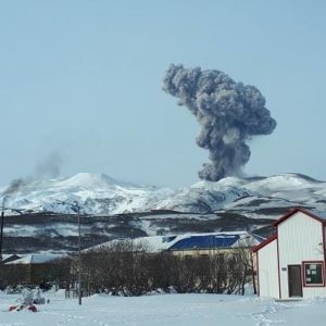
Merapi activity report from July 1 to 7, 2022:
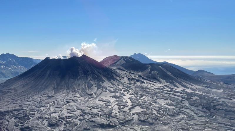
This week, 60 lava avalanches were observed in a dominant South-West direction towards the Bebeng River with a maximum slip distance of 2,000 m. On the South-West dome, a growth of the dome is observed, the volume of the dome is calculated at 1,645,000 m3. During this time, the central dome cannot be observed as it is mostly obstructed by smoke. However, based on the analysis of photos from the Deles5 camera station, no change in the height of the dome was observed, so the volume of the dome is calculated to remain at 2,582,000 m3.
Seismicity:
This week, the seismicity of Mount Merapi recorded:
2 shallow volcanic earthquake (VTB),
143 multi-phase earthquakes (MP),
683 avalanche earthquakes (RF),
8 emission earthquakes (DG),
1 low frequency earthquakes.
5 tectonic earthquakes (TT).
– The intensity of seismicity this week is still quite high.
Mount Merapi’s deformation, which was monitored using EDM this week, showed no significant changes.
Rainfall intensity was 42 mm/hour for 20 minutes at Kaliurang Post on July 5, 2022. There were no reports of lahars or additional flow in the rivers that originate at Mount Merapi.
Conclusion:
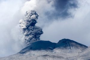
1. Merapi volcanic activity is still quite high in the form of effusive eruption activity. The state of the activity is defined at the « SIAGA » level.
2. The current potential danger is lava avalanches and hot clouds in the South-South-West sector covering the Boyong River for a maximum of 5 km, the Bedog River, Krasak, Bebeng for a maximum of 7 km. The Southeast sector covers the Woro River for a maximum of 3 km and the Gendol River for a maximum of 5 km. Meanwhile, the ejection of volcanic material in the event of an explosive eruption can reach a radius of 3 km around the summit.
The public should not carry out any activity in potentially dangerous areas, anticipate disturbances due to volcanic ash from the Merapi eruption and be aware of the dangers of lahars, especially when it rains around Merapi.
Source : BPPTKG.
Photo : BPPTKG
Alaska , Semisopochnoi :
AVO/USGS Volcanic Activity Notice
Current Volcano Alert Level: ADVISORY
Previous Volcano Alert Level: WATCH
Current Aviation Color Code: YELLOW
Previous Aviation Color Code: ORANGE
Issued: Friday, July 8, 2022, 9:03 AM AKDT
Source: Alaska Volcano Observatory
Notice Number: 2022/A744
Location: N 51 deg 55 min E 179 deg 35 min
Elevation: 2625 ft (800 m)
Area: Aleutians
Volcanic Activity Summary:
No ash emissions or explosive activity have been detected at Semisopochnoi since June 12. Seismic activity continues, but at low levels. Thus the Aviation Color Code and Volcano Alert Level are being lowered to YELLOW/ADVISORY.
Steaming and sulfur dioxide emissions from the active north crater of Mount Cerberus continue.
Small eruptions producing minor ash deposits within the vicinity of the active north crater of Mount Cerberus and ash clouds usually under 10,000 ft (3 km) above sea level have characterized the recent activity and could begin again with little warning.
Semisopochnoi is monitored by local seismic and infrasound sensors, satellite data, web cameras, and remote infrasound and lightning networks.
Recent Observations:
[Other volcanic cloud information] Steam and sulfur dioxide emissions from the active north crater of Mount Cerberus continue
Hazard Analysis:
[General hazards] Explosive activity and ash emissions at Semisopochnoi could increase again at any time.
Source : AVO
Photo : Lerner, Allan / Alaska Volcano Observatory / U.S. Geological Survey .
Canary Islands , Tenerife :
WEAK SEISMICITY AT FASNIA, EL TEIDE AND SWARM IN UCANCA CALDERA, TENERIFE.
Most notable of all is a small swarm in the Caldera de Ucanca, whose main event of magnitude 1.8 at 13.4 km depth is a hybrid event, or « tornillo », formed by a mixed tectonic earthquake to a volcanic LP event, and with a long signal which indicates a depressurization of fluids and magma at depth and which is accompanied by nearly twenty minor events, which have not been located by IGN and which could be the start of a new swarm in the next few hours.
A few days ago, in this same area of the caldera, there was another one.
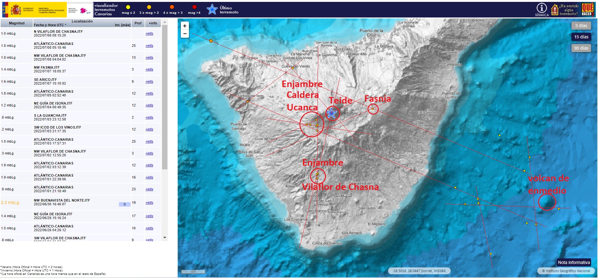
There are also three notable earthquakes, one of magnitude 1 without depth in the area of the Teide cable car (with an error of 12.4 km in depth) and another of 1.4 to 2.5 km in depth in the area of Fasnia, between the Siete Volcan Fuentes and Caldera de Diego Hernández. Another 1.1 in the Teide area some time ago at 2.7 km, where is the hydrothermal system that forms the Teide fumaroles.
We notice a change in trend in several GPS stations in Tenerife, which have stopped stagnating, to start to swell in an appreciable but insignificant way for 4-5 days, the last two being particularly noticed.
Source : Volcanes y Ciencia Hoy
Japan , Tsurumi :
Authorities raised the alert level for Tsurumi and Garandake volcanoes in Oita Prefecture, Kyushu to Level 2 on July 8 due to increased volcano activity. At least 57 small volcanic earthquakes occurred, mostly under Mount Garandake in early July 8. The Japan Meteorological Agency (JMA) has warned of possible eruptions from Garandake Crater with potential pyroclastic flows within 1 km (0.6 miles) of the crater.
As part of Level 2 measures, officials created 1 km (0.6 mile) radius exclusion zones around the two craters. Authorities stopped the Beppu Ropeway, evacuated Tsukahara Onsen and closed Prefectural Route 616 near the volcanoes.
Since the beginning of July 8, Oita Airport (OIT) has been operating normally. An eruption could cause localized transportation disruptions; flight delays could occur at Oita Airport (ILO) if there is a large ash plume. Ground transportation disruptions could also occur. Authorities could suspend or delay train service. Ashfall could cause slippery driving conditions on nearby roads and reduced visibility, resulting in localized traffic disruptions.
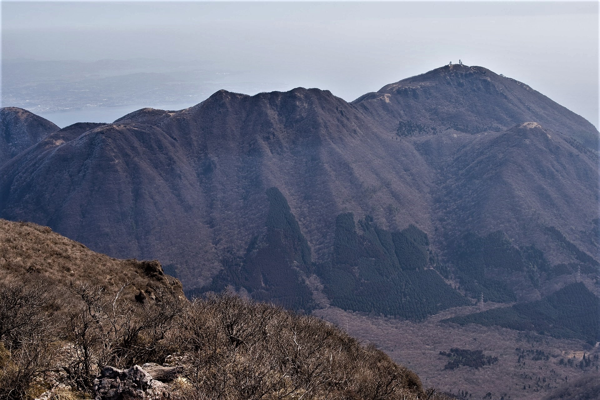
A group of lava domes rises above the noted hot spring resort city of Beppu on Japan’s Inland Sea, possibly within an ancient breached caldera. Two large lava domes, Tsurumidake and Yufudake (the highest at 1,584 m), are located at the east and west sides of the complex, respectively. Three smaller lava domes are on the N flank of Tsurumidake, including Garandake. The latest activity at both the andesitic-to-dacitic Tsurumi and Yufu groups postdates the 6300-year-old Akahoya ash from Kikai volcano. Pyroclastic flows dominated during older eruptions, whereas lava domes and lava flows are most common in more recent eruptions. An eruption about 2200 years ago from Yufudake began with collapse of the N flank that produced a debris avalanche and was followed by lava dome growth and associated pyroclastic flows. Only a single eruption, from Tsurumi in 867 CE, is known in historical time. The colorful hot spring pools and mudpots of Beppu along the coast form one of Japan’s most noted thermal areas.
Source : crisis24.garda.com , GVP .
Photo : Wikimedia
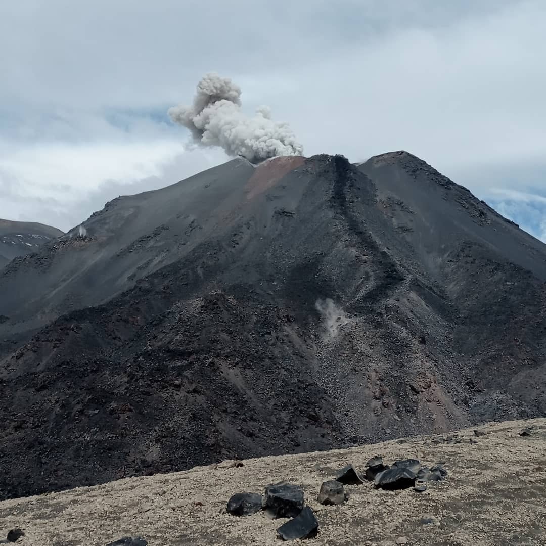
Chile , Nevados de Chillan :
Seismology
The seismological activity of the period was characterized by the recording of:
39 volcano-tectonic (VT) earthquakes associated with brittle rupture processes; the most energetic earthquake had a local magnitude (ML) equal to 1.4, whose location was estimated at a distance of 2.9 km north-northeast of the active crater.
Long period (LP), explosion (EX) and tremor (TR) seismicity continued to be recorded, associated with fluid dynamics within the volcanic system. 623 LP-type earthquakes were classified, including 147 linked to explosions at surface level, due to the presence of acoustic waves and/or gaseous emissions, often with the addition of particulate matter. The size of the largest LP earthquake estimated from the reduced displacement parameter (DR) reached a value equal to 232 cm2.
Regarding TR type seismicity, 251 episodes were recorded, the most important of which reached a DR of 113cm2. The current eruptive phase is characterized by low seismic energies related to fluid dynamics, but with a greater presence of TR-type events, contrasting with periods of greater volcanic activity that were characterized by the generation of more energetic explosive events.
Fluid Geochemistry
Data on sulfur dioxide (SO2) emissions obtained by optical differential absorption spectroscopy (DOAS) equipment, corresponding to the Philippi and Chillán stations, installed 1.5 km to the South-South-East (SSE) and 2.7 km east-southeast (ESE) of the active crater, respectively, showed an average value of 445 ± 95 t/d, with a maximum daily value of 760 t/d, recorded on 30 June. The decrease in SO2 emission rates is maintained, however, these are still above baseline, which is consistent with the presence of Dome 4, located inside the active Nicanor crater.
No anomalies were reported in sulfur dioxide (SO2) emissions into the atmosphere in the area near the volcanic complex, according to data published by Tropospheric Monitoring (TROPOMI) and Ozone Monitoring Instrument (OMI) Sulfur Dioxide Group. which is consistent with the low emission rates of this gas observed during the period.
Satellite thermal anomalies
1 thermal alert was recorded in the area associated with the volcanic complex during the period, with a Volcanic Radiative Power (VRP) of less than 1 MW on June 26, a value considered low according to the data processed by the Medium Infrared Observation Activity Volcanoes (MIROVA).
At the same time, according to the analytical processing of satellite images (Sentinel 2-L2A in combination of false color bands), luminance anomalies were observed on June 17, 19 and 27, with a total luminance surface estimated at 900 m2 (06/17/2022).

During the period evaluated, the activity of the Nevados de Chillán remains unchanged, in a state where the internal and external activity has presented a significant decrease compared to the previous phases, but with specific events that lead to emissions with a load of particles and the transitory appearance of incandescent phenomena. Seismic energy and productivity are lower, with a predominance of processes associated with fluid dynamics and at the surface, the emission of magmatic material seems to have ceased and/or it shows low emission rates. It remains as part of a minor eruption, prolonged in time and with transient increases. Monitoring parameters indicate a low near-term probability of escalation to more explosive or higher energy events, however, specific more energetic events may occur and result in surface activity. Due to the above, its technical alert level is maintained at yellow and its danger zone is within a radius of 2 km from the active crater.
Source : Sernageomin.
Photos : Sernageomin , Cesar Lara Cancino