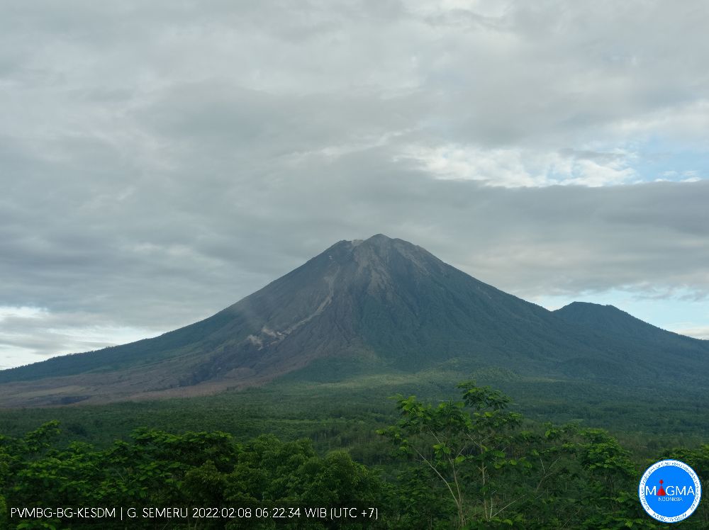
February 08 , 2022 .
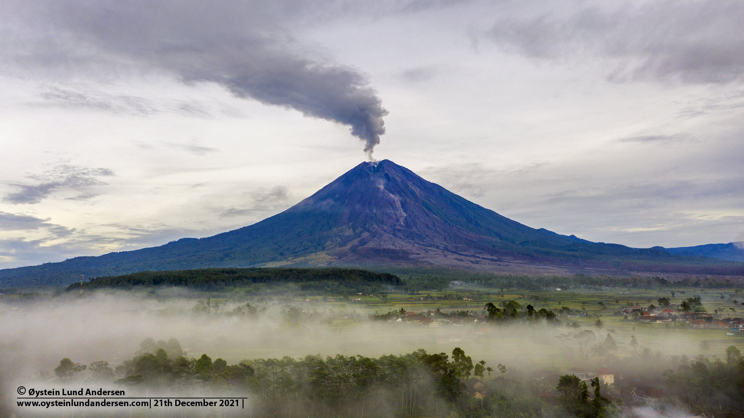
Indonesia , Semeru :
VOLCANO OBSERVATORY NOTICE FOR AVIATION – VONA
Issued : February 07 , 2022
Volcano : Semeru (263300)
Current Aviation Colour Code : ORANGE
Previous Aviation Colour Code : orange
Source : Semeru Volcano Observatory
Notice Number : 2022SMR22
Volcano Location : S 08 deg 06 min 29 sec E 112 deg 55 min 12 sec
Area : East java, Indonesia
Summit Elevation : 11763 FT (3676 M)
Volcanic Activity Summary :
Eruption with volcanic ash cloud at 22h49 UTC (05h49 local). Eruption and ash emission is continuing.
Volcanic Cloud Height :
Best estimate of ash-cloud top is around 13043 FT (4076 M) above sea level, may be higher than what can be observed clearly. Source of height data: ground observer.
Other Volcanic Cloud Information :
Ash-cloud moving to southeast.
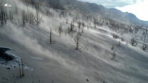
The volcano was clearly visible until it was covered in fog. White smoke from the crater was observed with moderate to high intensity about 100 meters above the summit. The weather is sunny to rainy, the wind is light in the North, South and West. The air temperature is around 22-30°C. An eruption was observed with a height of gray smoke of about 500 m, vertically. An avalanche was observed at a sliding distance of 100-200m towards the Kobokan River, the source of the avalanche was 3500m below the crater. An incandescence was observed when the visual of the mountain was clear.
Earthquakes are related to magma, tectonic activity and lahars. We record:
– 73 earthquakes of eruptions/explosions
– 4 avalanche earthquakes
– 11 emission earthquakes
– 6 harmonic tremors
– 2 distant tectonic earthquakes
-1 flood earthquake
Source : Magma Indonésie , PVMBG.
Photos : PVMBG , Oystein Lund Andersen.
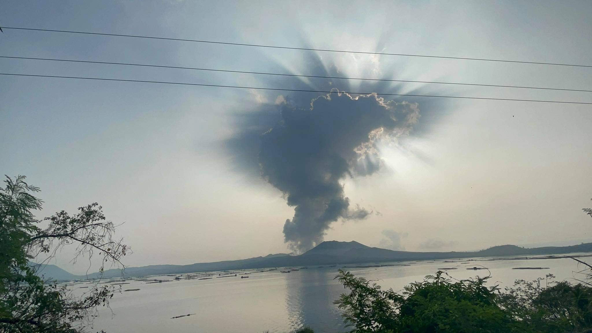
Philippines , Taal :
TAAL VOLCANO BULLETIN 08 February 2022 8:00 AM
In the past 24-hour period, the Taal Volcano Network recorded one (1) volcanic earthquake and low-level background tremor that has persisted since July 7, 2021. Activity at the Main Crater was dominated by upwelling of hot volcanic fluids in its lake which generated plumes 1200 meters tall that drifted southwest and south-southwest. Sulfur dioxide (SO2) emission averaged 7,008 tonnes/day on 04 February 2022. Based on ground deformation parameters from electronic tilt, continuous GPS and InSAR monitoring, Taal Volcano Island and the Taal region has begun deflating in October 2021.
Alert Level 2 (Increased Unrest) prevails over Taal Volcano. DOST-PHIVOLCS reminds the public that at Alert Level 2, sudden steam- or gas-driven explosions, volcanic earthquakes, minor ashfall, and lethal accumulations or expulsions of volcanic gas can occur and threaten areas within and around TVI. DOST-PHIVOLCS strongly recommends that entry into Taal Volcano Island, Taal’s Permanent Danger Zone or PDZ must be strictly prohibited, especially the vicinities of the Main Crater and the Daang Kastila fissure, and extended stays on Taal Lake.
Source : Phivolcs
Photo : Seys Marasigan / Seys Channel
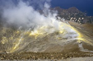
Peru , Sabancaya :
Analysis period: from January 31, 2022 to February 06, 2022, Arequipa, February 07, 2022.
Alert level: ORANGE
The Geophysical Institute of Peru (IGP) reports that the eruptive activity of the Sabancaya volcano remains at moderate levels, that is to say with the recording of an average of 25 daily explosions, with columns of ash and of gas up to 1.7 km altitude above the summit of the volcano and their subsequent dispersion. Therefore, for the following days, no significant change is expected in eruptive activity.
The IGP recorded and analyzed the occurrence of 175 earthquakes of volcanic origin, associated with the circulation of magmatic fluids inside the Sabancaya volcano. An average of 25 explosions was recorded daily. During this period, Volcano-Tectonic (VT) type earthquakes associated with rock fracturing were located mainly in the northwest and southwest of Sabancaya and presented magnitudes of M 2.2.
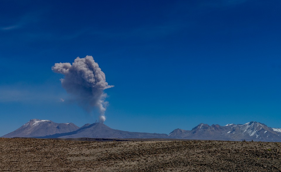
Monitoring the deformation of the volcanic structure using GNSS techniques (processed with fast orbits) does not show any significant anomalies. However, in general, an inflation process has been observed in the northern sector (surroundings of the Hualca Hualca volcano). Visual surveillance identified columns of gas and ash up to 1.7 km above the summit of the volcano, which were scattered towards the southeast, south and southwest sectors of Sabancaya. Satellite recordings have identified the presence of two thermal anomalies, with a maximum value of 13 MW, associated with the presence of a lava body on the surface of the crater of the volcano.
RECOMMENDATIONS
• Keep the volcanic alert level orange.
• Do not approach within a radius of less than 12 km from the crater.
Source : CENVUL
Photo : Pixabay
Hawaii , Kilauea :
19°25’16 » N 155°17’13 » W,
Summit Elevation 4091 ft (1247 m)
Current Volcano Alert Level: WATCH
Current Aviation Color Code: ORANGE
Activity Summary:
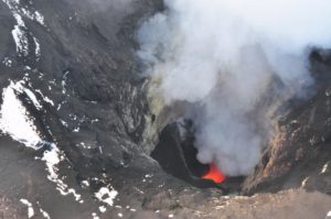
The summit eruption of Kīlauea Volcano, within Halemaʻumaʻu crater, has continued with slight fluctuations in lava output over the past 24 hours. Lava activity remains confined to the crater, and there are no indications of the eruption migrating elsewhere on Kīlauea.
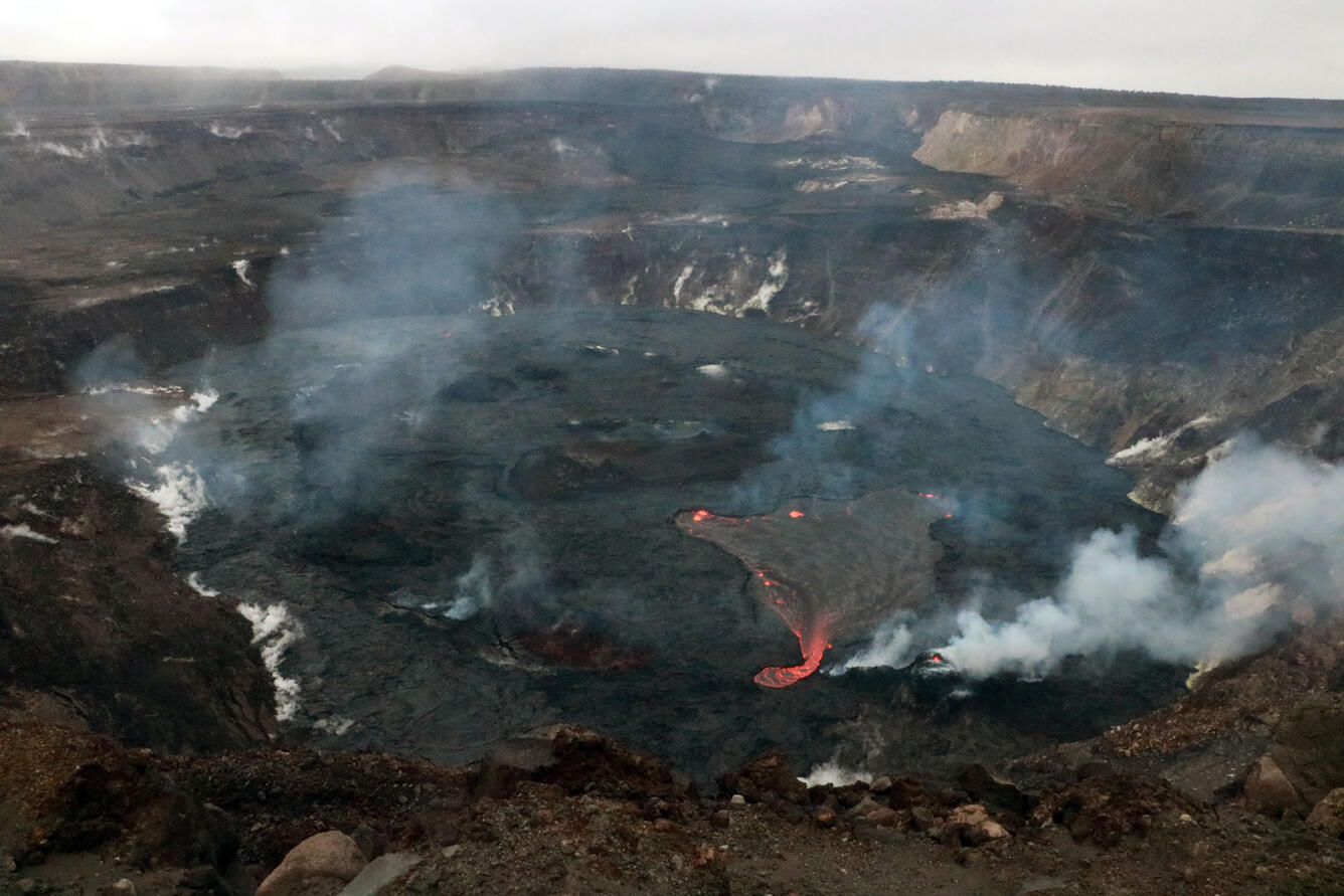
The lava lake in Halema‘uma‘u crater at the summit of Kīlauea was visibly full beneath overcast skies during a Hawaiian Volcano Observatory eruption monitoring field shift on February 4, 2022. This photo was taken from west rim of the Kīlauea caldera, in the vicinity of the KWcam.
Halemaʻumaʻu Lava Lake Observations:
Effusion of lava from the western vent within Halemaʻumaʻu crater has continued with slight fluctuations over the past 24 hours. Output to the active lava lake in the western portion of the crater temporarily declined in association with the deflationary phase of a single deflation-inflation (DI) event in the summit region yesterday. Unlike full eruptive pauses in recent weeks, the surface of the lava lake did not fully stagnate and crust over during this DI event, although circulation was slightly diminished. Multiple ooze-outs of lava have been weakly active along the northern, eastern, and southern margins of the crater at various times over the past 24 hours.
During the deflationary phase of yesterday’s DI event, the surface of the active lava lake dropped approximately 4 meters (13 feet) before rising back up during the subsequent inflationary phase. The active lake surface has been stabilizing at 833 meters (2733 feet) above sea level between DI events in recent days, with a depth of approximately 92 meters (302 feet) relative to when lava emerged on September 29, 2021.
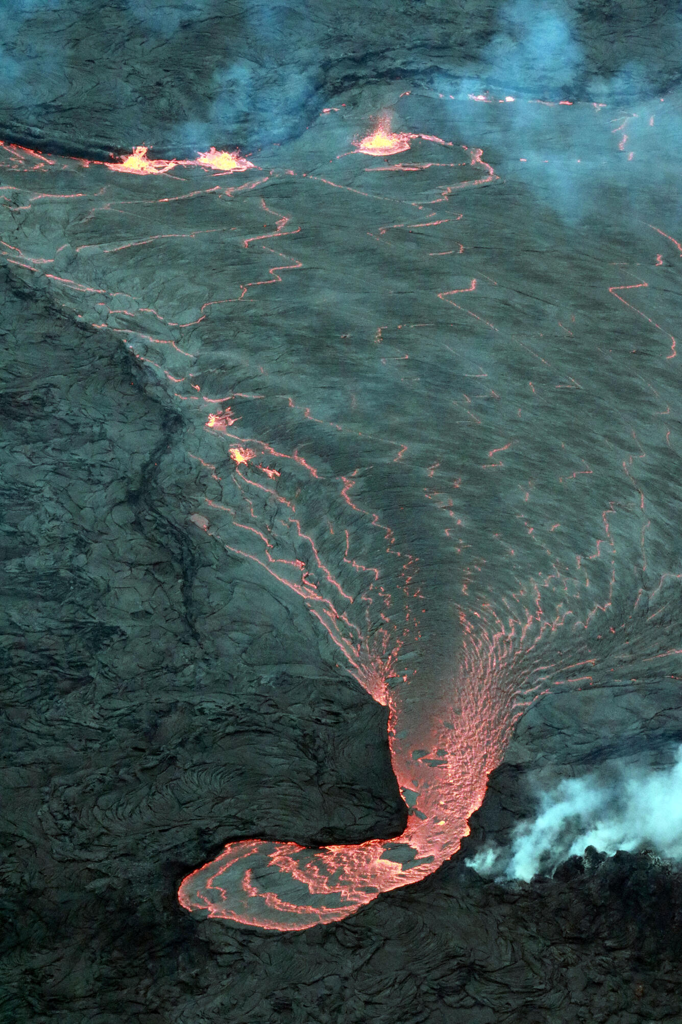
Lava cascades from a pond north of the west vent in Halema‘uma‘u into the active lava lake in the western portion of the crater. On the afternoon of February 4, the pond was measured as about one meter (a few feet) higher than the larger lava lake at the summit of Kīlauea.
Summit Observations:
Summit tiltmeters tracked a single DI event yesterday, starting mid-morning and continuing into the late afternoon. Just within the past hour, summit deflationary tilt has returned once again, possibly marking the onset of another DI event. Yesterday’s event and the presently ongoing deflationary tilt have only seen minimal declines in eruption-related volcanic tremor, unlike full eruptive pauses in recent weeks. Earthquake activity in the summit region remains below background level. A sulfur dioxide (SO2) emission rate of approximately 4,500 tonnes per day (t/d) was measured on February 1, the day before the most recent eruptive pause.
Source : HVO.
Photos : USGS/ K. Mulliken.
Spain / La Palma , Cumbre Vieja :
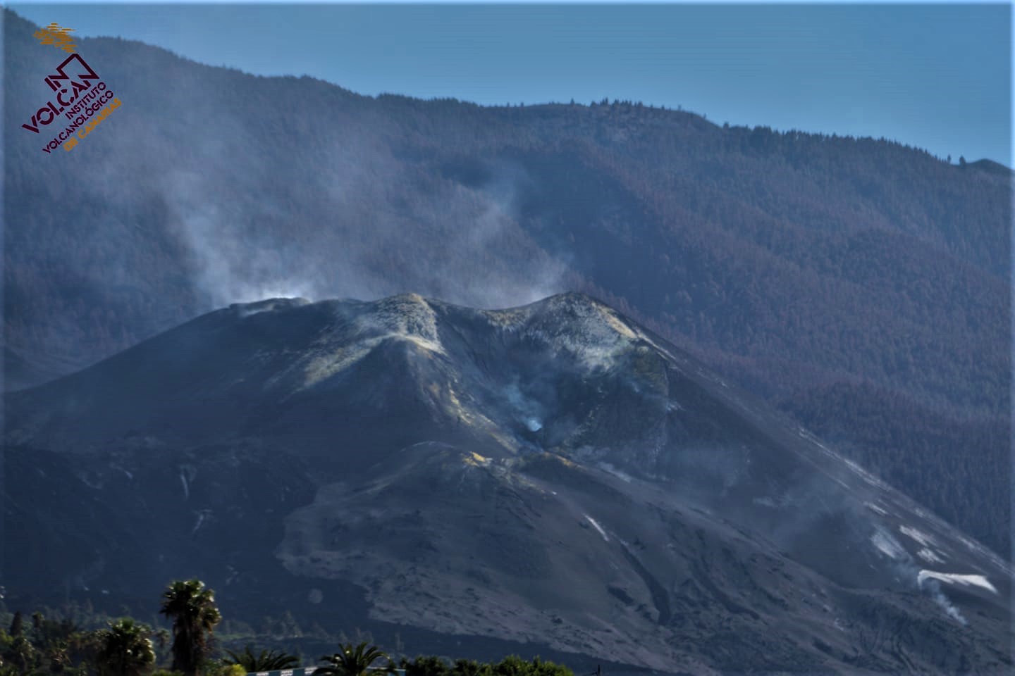
Post-eruption activity on Cumbre Vieja, La Palma.
During the last 7 days, since the last communication (the 25th at 9:00 UTC), 103 earthquakes have been located on the island of La Palma.
The magnitudes are between 0.4 and 2.2 (mbLg). 4 of these earthquakes were felt weakly by the population with intensity II (EMS98).
The location of the hypocenters continues under the central area of Cumbre Vieja in the same areas as the previous days, at depths between 0 and 18 km. Three earthquakes with depths between 21 and 37 km were located during this period.
The network of permanent GNSS stations on the island does not show significant deformations that could be associated with volcanic activity.
The height of the cone is measured, obtaining a value of 1,120 m above sea level.
The taking of fumarolic gas samples in the crater of the main building continues, as well as the maintenance of the geochemical instrumentation deployed near it to follow in detail the post-eruptive stage.
Source : IGNes
Photo : Involcan.