February 02 , 2022.
Russia / Kurils Islands , Chikurachki :
VOLCANO OBSERVATORY NOTICE FOR AVIATION (VONA)
Issued: February 02 , 2022
Volcano: Chikurachki (CAVW #290360)
Current aviation colour code: ORANGE
Previous aviation colour code: orange
Source: KVERT
Notice Number: 2022-13
Volcano Location: N 50 deg 19 min E 155 deg 27 min
Area: Northern Kuriles, Russia
Summit Elevation: 1816 m (5956.48 ft)
Volcanic Activity Summary:
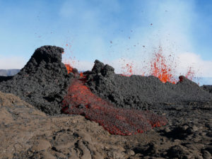
A moderate eruptive activity of the volcano continues. Satellite data by KVERT showed an ash plume extended about 180 km to the east-south-east from the volcano.
A strong gas-steam activity of the volcano continues. Ash explosions up to 6 km (19,700 ft) a.s.l. could occur at any time. Ongoing activity could affect low-flying aircraft.
Volcanic cloud height: 4000 m (13120 ft) AMSL Time and method of ash plume/cloud height determination: 20220202/0430Z – Visual data
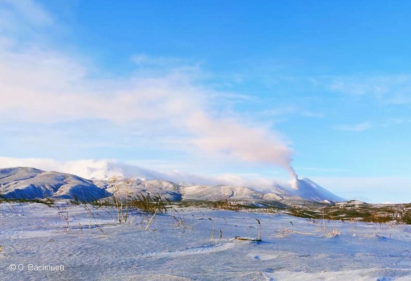
The explosive eruption of Chikurachki volcano on 02 February, 2022. View from Podgorny cape, Paramushir Island.
Other volcanic cloud information:
Distance of ash plume/cloud of the volcano: 180 km (112 mi)
Direction of drift of ash plume/cloud of the volcano: ESE / azimuth 109 deg
Time and method of ash plume/cloud determination: 20220202/0327Z – NPP (4m5).
Chikurachki, the highest volcano on Paramushir Island in the northern Kuriles, is actually a relatively small cone constructed on a high Pleistocene volcanic edifice. Oxidized basaltic-to-andesitic scoria deposits covering the upper part of the young cone give it a distinctive red color. Frequent basaltic plinian eruptions have occurred during the Holocene.

Lava flows from 1781-m-high Chikurachki reached the sea and form capes on the NW coast; several young lava flows also emerge from beneath the scoria blanket on the eastern flank. The Tatarinov group of six volcanic centers is located immediately to the south of Chikurachki, and the Lomonosov cinder cone group, the source of an early Holocene lava flow that reached the saddle between it and Fuss Peak to the west, lies at the southern end of the N-S-trending Chikurachki-Tatarinov complex. In contrast to the frequently active Chikurachki, the Tatarinov volcanoes are extensively modified by erosion and have a more complex structure. Tephrochronology gives evidence of only one eruption in historical time from Tatarinov, although its southern cone contains a sulfur-encrusted crater with fumaroles that were active along the margin of a crater lake until 1959.
Source : Kvert , GVP.
Photo : O. Vasiliev , Məmməd Ramin .
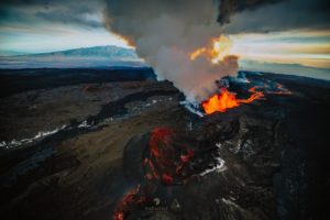
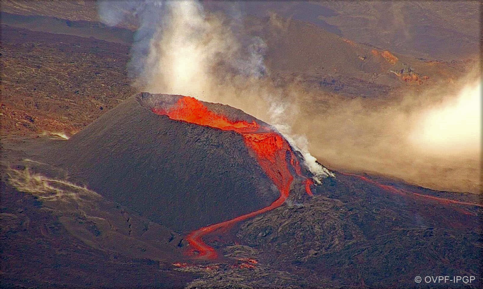
La Réunion , Piton de la Fournaise :
Seismicity
In January 2022, the OVPF recorded in the Piton de la Fournaise massif in total:
• 349 superficial volcano-tectonic earthquakes (0 to 2.5 km above sea level) under the summit craters;
• 1 deep earthquake (below sea level);
• 505 collapses (in the Cratère Dolomieu, the ramparts of the Enclos Fouqué and the Piton de Crac, and of the Rivière de l’Est).
Following the start of the eruption of December 22, 2021, a gradual decrease in seismicity was recorded, going from 42 superficial earthquakes on December 22 (after the opening of the cracks) to 1 superficial earthquake per day over the period from December 24, 2021 to January 6, 2022.
A gradual increase in seismicity was observed from January 7 to 16 (with up to 99 summit earthquakes on January 16). These earthquakes were located under the southern edge of the summit, between 0.2 and 0.8 km above sea level, and suggested a destabilization of the southern roof of the magmatic reservoir, probably linked to the emptying of the reservoir (also suggested by the deflation of the summit zone; see next section).
After the end of the eruption on January 17, 2022 (02:10 local time, January 16 22:10 UTC time), volcano-tectonic earthquakes were still recorded below the summit with a gradual decrease in their number. Over the last ten days of January, an average of 4 summit volcano-tectonic earthquakes per day was recorded.
Deformation
Throughout the eruption from December 22, 2021 to January 17, 2022, a slight deflation of the edifice was recorded, linked to the transfer of magma from the magmatic storage zone, located approximately 2 km below the summit, towards the eruptive site.
After the end of the eruption on January 17, 2022, a slight recovery in peak inflation seems to resume. This parameter will be confirmed next month.
CO2 concentration in the soil
On the proximal site of the Gîte du volcan, a sharp drop in flows with very low CO2 values was detected after January 3, 2022.
Since the end of the eruption a new phase of increase is recorded, but with a lower rate.
Source et photo : OVPF.
Read the article : https://www.ipgp.fr/sites/default/files/ovpf_20220201_bullmensu.pdf
Italy / Sicily , Etna :
WEEKLY BULLETIN, from January 24, 2022 to January 30, 2022. (issue date February 01, 2022)
ACTIVITY STATUS SUMMARY
In the light of the surveillance data, it is highlighted:
1) VOLCANOLOGICAL OBSERVATIONS: Discontinuous Strombolian activity and emission of volcanic ash at the level of the Southeast Crater, degassing activity at the level of the other summit craters.
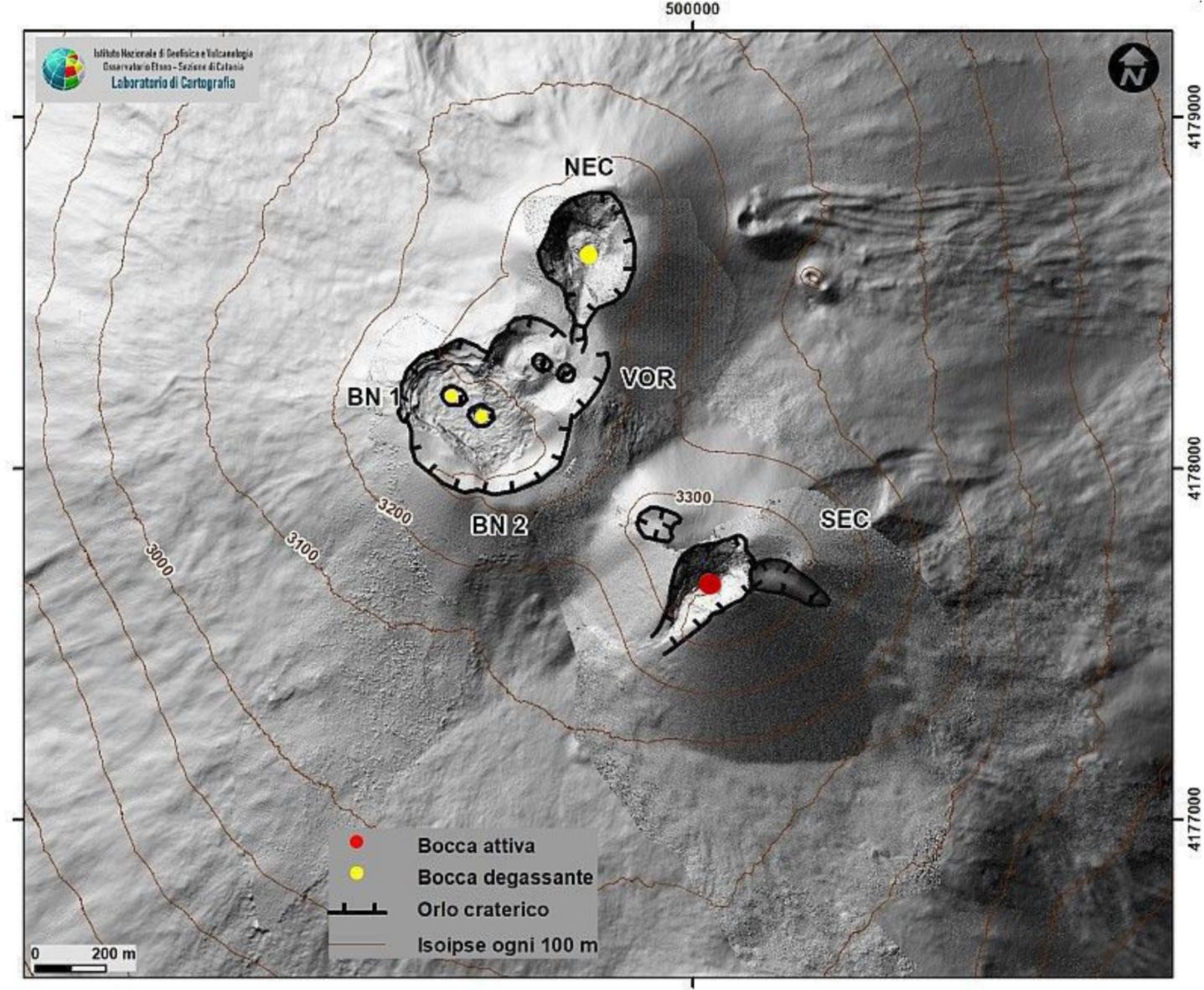
2) SEISMOLOGY: Low fracturing seismic activity, low/medium tremor amplitude, sources of tremor under the Central and Southeast Craters.
3) INFRASOUND: Variable infrasound activity between high and low levels. The activity at Bocca Nuova is predominant.
4) GROUND DEFORMATIONS: There are no significant variations during the last week.
5) GEOCHEMISTRY: SO2 flux at a low level
Soil CO2 flux shows average values.
The partial pressure of dissolved CO2 in groundwater shows values in seasonal variability.
There are no updates on the isotope ratio of helium. The latest available data showed medium to high values (data from January 4, 2022).
6) SATELLITE OBSERVATIONS: The thermal activity in the summit area observed by satellite was at a low level.

VOLCANOLOGICAL OBSERVATIONS
The monitoring of the volcanic activity of Etna, during the week in question, was carried out by analyzing the images of the network of surveillance cameras of the INGV, Osservatorio Etneo (INGV-OE). Adverse weather conditions have rendered remote observation of volcanic activity discontinuous.
During the period under review, the activity of Etna was characterized by the resumption of eruptive activity at the level of the Southeast Crater (SEC) coupled with a variable degassing regime of the other craters: Northeast , Bocca Nuova and Voragine. In particular, from January 30, the analysis of the surveillance images indicated from ~00:15 GMT, the presence of a modest and discontinuous intra-crater Strombolian activity at the Southeast Crater. This activity, which lasted all day with variable intensity and frequency over time, produced weak ash emissions which quickly dispersed near the summit area.
Source and photos : INGV.
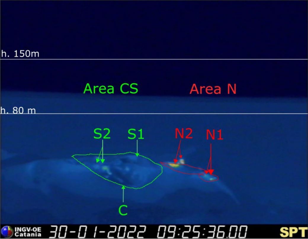
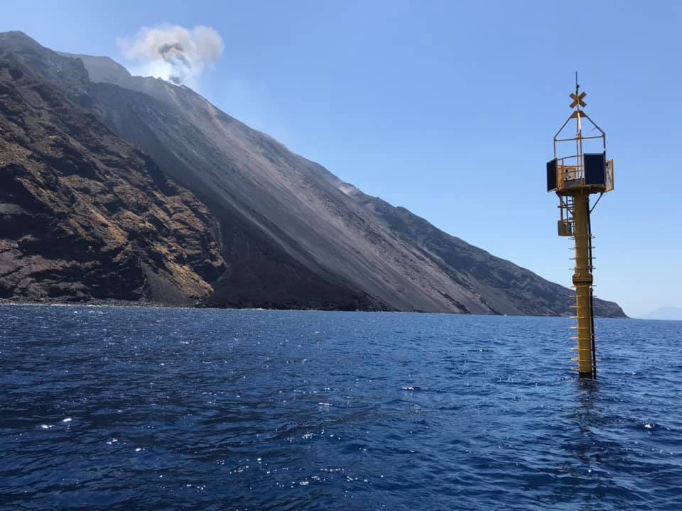
Italy , Stromboli :
WEEKLY BULLETIN, from January 24, 2022 to January 30, 2022. (issue date February 01, 2022)
ACTIVITY STATUS SUMMARY
In the light of the surveillance data, it is highlighted:
1) VOLCANOLOGICAL OBSERVATIONS: During this period, a normal Strombolian-type explosive activity was observed with weak and sporadic projection activity in the North zone. The total hourly frequency of explosions fluctuated between average values (10-15 events / h). The intensity of the explosions was low in the area of the North crater and variable from low to medium in the area of the Center-South crater.
2) SEISMOLOGY: The seismological parameters monitored do not show any significant variations.
3) GROUND DEFORMATIONS: Ground deformation monitoring networks have not detected any significant variations
4) GEOCHEMISTRY: SO flux at an average level.
CO2 flux in the crater area on high values.
C/S ratio on mean values.
There are no updates on the isotope ratio of helium in groundwater.
5) SATELLITE OBSERVATIONS: The thermal activity observed by satellite was at a low level.
VOLCANOLOGICAL OBSERVATIONS
During the observation period, the eruptive activity of Stromboli was characterized through the analysis of images recorded by the INGV-OE surveillance cameras (altitude 190m, Punta Corvi, altitude 400m and Pizzo). The explosive activity was mainly produced by 4 (four) eruptive vents located in the North crater area and 2 (two) eruptive vents located in the Center-South crater area. All the mouths are placed inside the depression which occupies the terrace of the crater.
Due to the unfavorable weather conditions on January 26, 27 and 28, the visibility of the crater terrace was insufficient for a correct description of the eruptive activity.
Sector N1, with two emission points, located in the North crater area produced low intensity explosions (less than 80 m high) emitting fine materials (ash) mixed with coarse materials (lapilli and bombs) . Sector N2, with two emission points, showed low intensity explosive activity (less than 80 m in height) emitting coarse materials with weak and sporadic projection activity. The average frequency of explosions varied from 6 to 12 events/h.
In the Center-South zone, sectors S1 and C did not show significant explosive activity, while the two vents located in sector S2 produced explosions, even simultaneously, of mainly medium-low intensity (sometimes the products of the explosions exceeded 80 m in height) emitting coarse materials mixed with fines. The frequency of explosions was almost constant with 3 events/h.
Source : INGV.
Photos : INGV , LGS .
Colombia , Nevado del Ruiz :
Subject: Nevado del Ruiz volcano activity level bulletin.
The activity level continues at the yellow activity level or (III): changes in the behavior of volcanic activity.
Regarding the monitoring of the activity of the Nevado del Ruiz volcano, the COLOMBIAN GEOLOGICAL SERVICE reports that:
The seismicity generated by rock fracturing increased slightly in the number of earthquakes and decreased in the seismic energy released, compared to the previous week. This seismic activity was located mainly in the Northwest, East sectors and in the Arenas crater. The depth of the earthquakes varied between 0.5 and 8.3 km. The maximum magnitude recorded during the week was 1.5 ML (Local Magnitude) corresponding to an earthquake recorded on January 30 at 11:40 a.m. (local time), located 6.0 km southeast of the Arenas crater, at a depth of 3.9 km.

During the week, there were several episodes of « drumbeat » type seismicity on January 25, 28 and 30, of low energy level and associated with rock fracturing. This seismicity has been linked to the processes of ascent, emplacement-growth and evolution of a lava dome at the bottom of the Arenas crater.
The seismicity related to fluid dynamics inside the volcanic conduits showed a similar level in the number of earthquakes and a decrease in the seismic energy released, compared to the previous week. This seismic activity was characterized by the occurrence of continuous volcanic tremors, tremor pulses, earthquakes of long and very long period types, which had moderate energy levels and variable spectral content. These earthquakes were located mainly in the Arenas Crater. Some of these signals were associated with ash emissions and / or incandescence confirmed by the cameras installed in the volcano area.
Source : SGC.
Photo : archivo/Caracol Radio
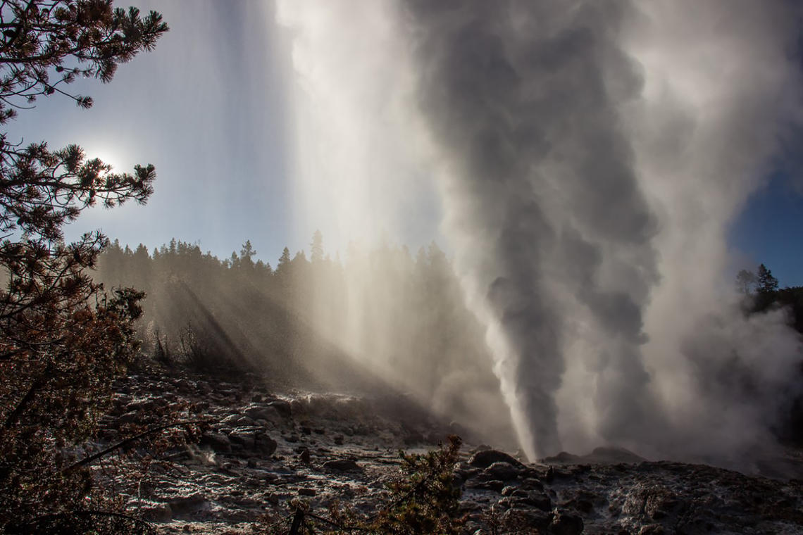
United – States , Yellowstone :
44°25’48 » N 110°40’12 » W,
Summit Elevation 9203 ft (2805 m)
Current Volcano Alert Level: NORMAL
Current Aviation Color Code: GREEN
Recent work and news
Steamboat Geyser continues to be active in 2022, although the frequency of its eruptions has decreased dramatically compared to the preceding 3 years. The geyser experienced one major water eruption in the past month, on January 23, bringing the total number of eruptions during the year to, well, one.
Seismicity
During January 2022, the University of Utah Seismograph Stations, responsible for the operation and analysis of the Yellowstone Seismic Network, located 105 earthquakes in the Yellowstone National Park region. The largest event of the month was a minor earthquake of magnitude 2.5 located ~14 miles south-southwest of Mammoth Hot Springs in Yellowstone National Park on January 5 at 6:43 PM MST.
January seismicity in Yellowstone included a sequence of 42 earthquakes that occurred during January 5-31 (MST) in the area of the largest earthquake of the month, ~ 14 miles south-southwest of Mammoth Hot Springs. Earthquake sequences like these are common and account for roughly 50% of the total seismicity in the Yellowstone region.
Yellowstone earthquake activity remains at background levels.
Ground deformation
No significant changes in ground deformation patterns were observed in data from continuous GPS stations over the past several months. No deformation is apparent in a station near Norris Geyser Basin, and stations within Yellowstone Caldera continue to subside at an overall rate of 2-3 cm (1 in) per year. This subsidence has been ongoing since 2015. Heavy snowfall in mid-December resulted in anomalous signals at several stations in the region, but these signals disappeared by early January, once the snow had melted away from the GPS antennas.
Source : YVO.
Photo : Mara Reed ( Steamboat Geyser ).