September 24 , 2021.
Spain / La Palma , Cumbre Vieja :
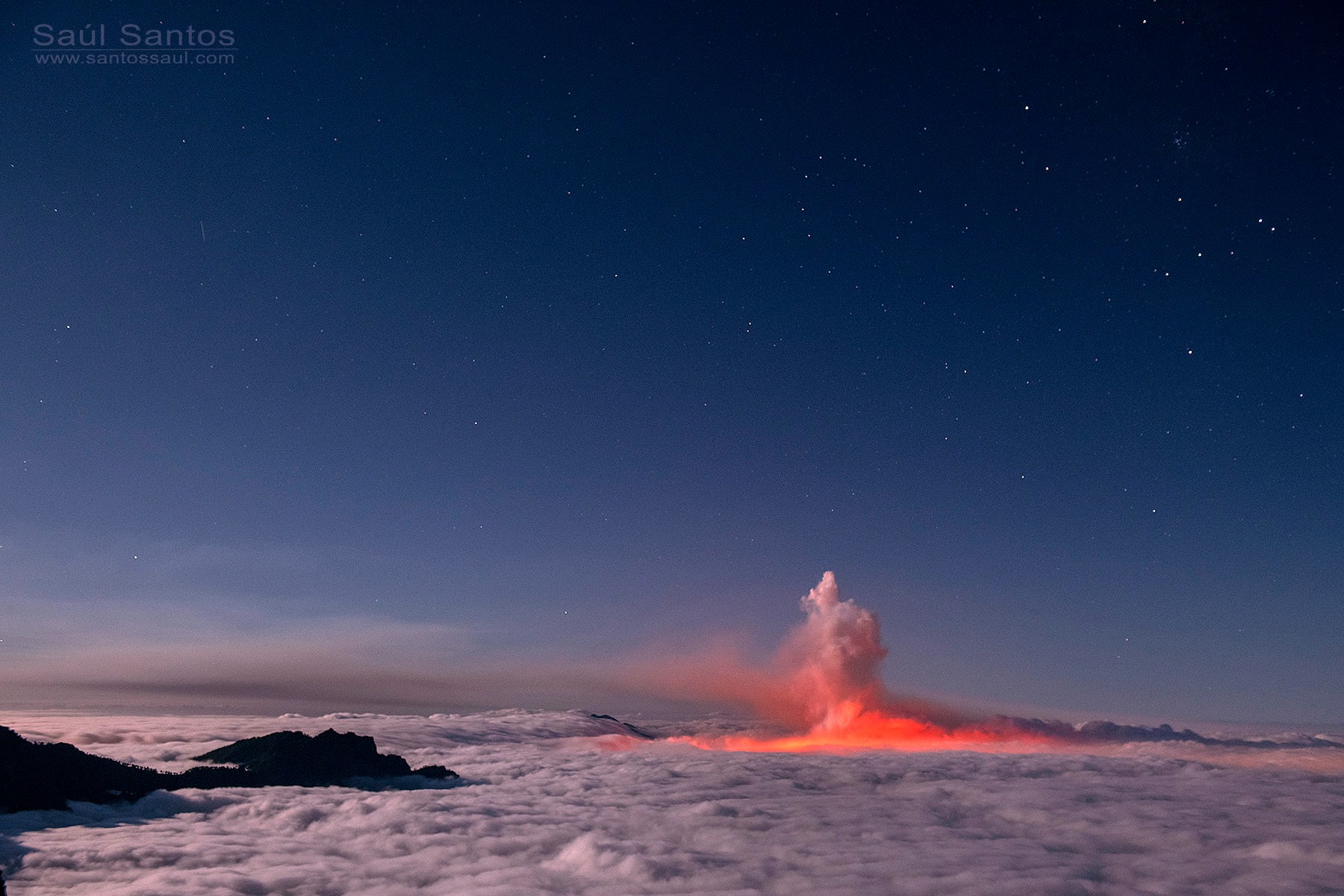
One of the lava flows from the Cumbre Vieja volcano stops and the other advances just four meters per hour towards the sea.
The main flow, which is up to 12 meters high, will not reach the coast this Thursday or Friday. The magma destroyed around 400 houses and covers more than 166 hectares
The lava tongues created by the volcano will not arrive this Thursday or tomorrow Friday at the sea, as detailed this afternoon Maria José Blanco, director of the National Geographic Institute (IGN), who took stock of the situation of the Cumbre Vieja volcano and the magma expelled by it, which destroys everything in its way to the coast. Blanco detailed that one of the flows has stopped and the other is moving very slowly, at about four meters per hour, according to the measurement taken last night. « Neither today nor tomorrow it will reach the sea », assured the director of IGN, who specified that the front of one of the languages measures 500 meters and that it reaches 12 meters high at its points. the highest.
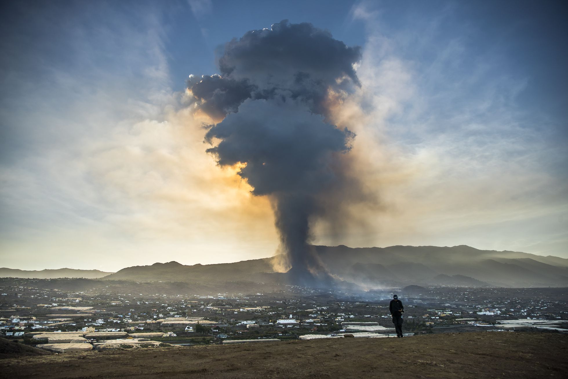
The IGN director explained that there are several reasons why the lava is advancing more slowly: “It has to incorporate everything that has already been emitted. Other than that, it cools down over a much longer route from the point of emission to the front of the pour. And by assimilating all the material on which it passes. Lava flows, except those that are very fluid, generally slow down as they move away from the emitting center. Blanco also detailed that the emission front is still active with a plume of smoke and ash reaching 4,500 meters above sea level. « The deformations have remained stable for several days and the seismicity has manifested itself, not only at a low level, but long-period type signals have been recorded, in particular with regard to the explosive phenomena of yesterday », specified the expert.
Lava spilled by the Cumbre Vieja volcano on the island of La Palma already covers more than 166 hectares, according to the latest data from the European Earth Observation System Copernicus. In this field, he destroyed more than 400 homes, as Canaries President Angel Victor Torres quantified on Thursday. Faced with the housing emergency, which has forced the eviction of 6,000 people from their homes, the Canary Islands government has announced that it will finalize the purchase of 280 buildings on the island.
Meanwhile, assistance to the nearly 6,000 people who have had to leave their homes and their jobs is increasing day by day. The President of the Canaries, Angel Víctor Torres, announced on Wednesday the start of the relocations of the 137 people affected by the flows of the Cumbre Vieja volcano who have stayed since Sunday at the barracks of Breña Baja.
A new plume reaches six kilometers high and the ash reaches the north of Tenerife.
The powerful explosions heard yesterday in the area of the volcano eruption are part of the eruption process.
With the change in wind direction yesterday, ash appeared for the first time in Santa Cruz de La Palma, but it has already reached even the north of Tenerife.
Source : El Pais. diariodeavisos.elespanol
Photos : SAMUEL SANCHEZ / El Pais , Saul Santos .
Kamchatka , Karymsky :
VOLCANO OBSERVATORY NOTICE FOR AVIATION (VONA)
Issued: September 24 , 2021
Volcano: Karymsky (CAVW #300130)
Current aviation colour code: ORANGE
Previous aviation colour code: orange
Source: KVERT
Notice Number: 2021-116
Volcano Location: N 54 deg 2 min E 159 deg 26 min
Area: Kamchatka, Russia
Summit Elevation: 1486 m (4874.08 ft)
Volcanic Activity Summary:
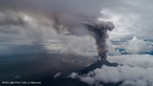
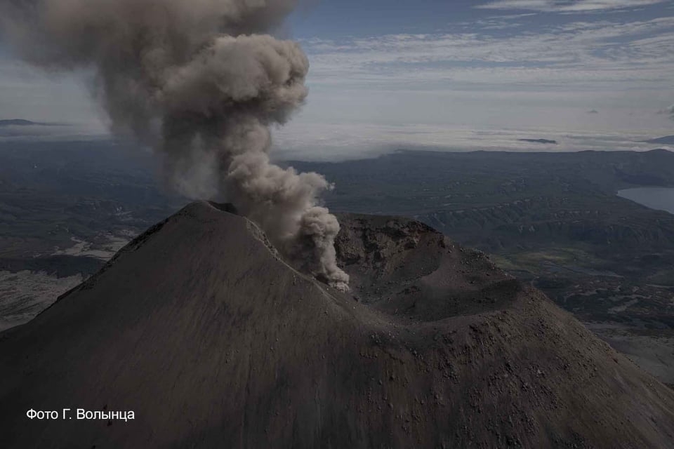
A moderate eruptive activity of the volcano continues. Satellite data by KVERT showed: explosions sent ash up to 4 km a.s.l., an ash plume is extending for 15 km to the northeast of the volcano.
A moderate eruptive activity of the volcano continues. Ash explosions up to 7-8 km (23,000-26,200 ft) a.s.l. could occur at any time. Ongoing activity could affect international and low-flying aircrafts.
Volcanic cloud height:
4000 m (13120 ft) AMSL Time and method of ash plume/cloud height determination: 20210924/0100Z – Himawari-8
Other volcanic cloud information:
Distance of ash plume/cloud of the volcano: 15 km (9 mi)
Direction of drift of ash plume/cloud of the volcano: ENE / azimuth 69 deg
Time and method of ash plume/cloud determination: 20210924/0100Z – Himawari-8
Source : Kvert
Photo : kvert , G. Volynets
Indonesia , Semeru :
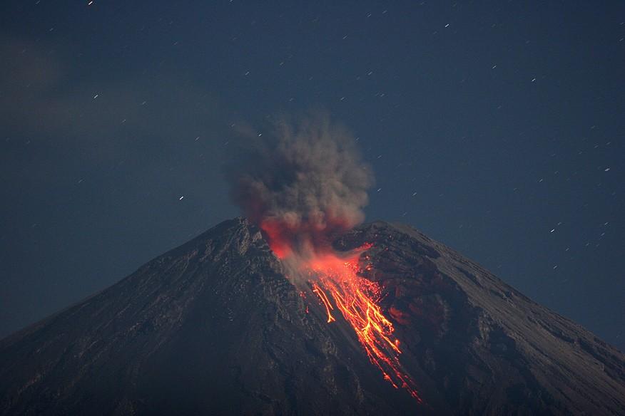
Level of activity at level II (WASPADA) since May 2, 2012. The Semeru volcano (3676 m above sea level) erupts intermittently. There are explosive and effusive eruptions, producing lava flows towards the southern and south-eastern slopes, as well as ejections of incandescent rocks around the summit crater.
The volcano is covered in fog. No smoke from the crater was observed. The weather is sunny to cloudy, the wind blows weak to moderate in the North-East, South, South-West and West. Air temperature 20-28 ° C.
According to the seismographs of September 23, 2021, it was recorded:
60 eruption earthquakes
10 earthquakes of emissions
1 deep volcanic earthquake
2 distant tectonic earthquakes
VOLCANO OBSERVATORY NOTICE FOR AVIATION – VONA.
Issued : September 23 , 2021
Volcano : Semeru (263300)
Current Aviation Colour Code : ORANGE
Previous Aviation Colour Code : orange
Source : Semeru Volcano Observatory
Notice Number : 2021SMR56
Volcano Location : S 08 deg 06 min 29 sec E 112 deg 55 min 12 sec
Area : East java, Indonesia
Summit Elevation : 11763 FT (3676 M)
Volcanic Activity Summary :
Eruption with volcanic ash cloud at 01h30 UTC (08h30 local). Eruption and ash emission is continuing.
Volcanic Cloud Height :
Best estimate of ash-cloud top is around 12403 FT (3876 M) above sea level, may be higher than what can be observed clearly. Source of height data: ground observer.
Other Volcanic Cloud Information :
Ash-cloud moving to West.
Source : PVMBG , Magma Indonésia.
Photo : M. Rietze / wikipedia .
Ecuador , Reventador :
DAILY REPORT OF THE STATE OF THE REVENTADOR VOLCANO, Thursday 23 September 2021.
Information Geophysical Institute – EPN.
Surface activity level: High, Surface trend: No change.
Internal activity level: Moderate, Internal trend: No change.
Seismicity: From September 22, 2021, 11:00 a.m. to September 23, 2021, 11:00 a.m.
There was no cut in the data transmission from the reference station (LAV4) for the seismic statistics
Explosion (EXP) 68 events
Long periods: (LP) 75 events
Tremors d’Émission (TREMI) 8 events
Harmonic Tremors (TRARM) 1 event.
Rains / lahars: There were several episodes of rains in the area which did not generate lahars.
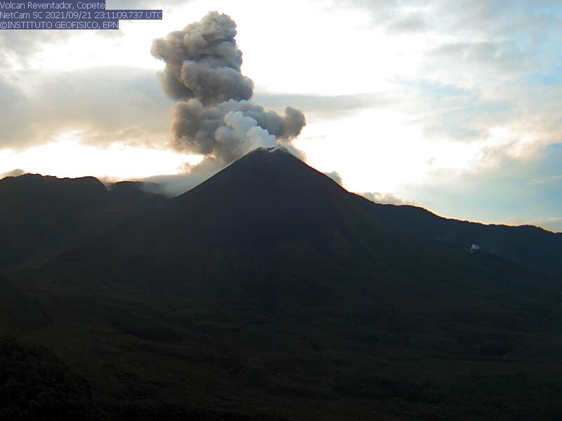
Emission / Ash Column: No emissions were observed through the cameras, however, the Washington VAAC recorded 2 ash emission alerts observed by satellites that reached heights of 1000 meters above the level from the crater in a westerly direction.
Other monitoring parameters: FIRMS has recorded a thermal alert in the last 24 hours.
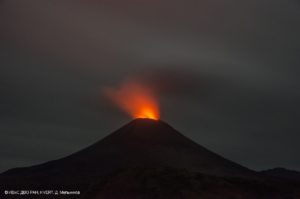
Observations: Last night, an incandescence was observed in the crater, the rest of the time the volcano was mostly cloudy.
Alert level: Orange.
Source et photo : IG-EPN.
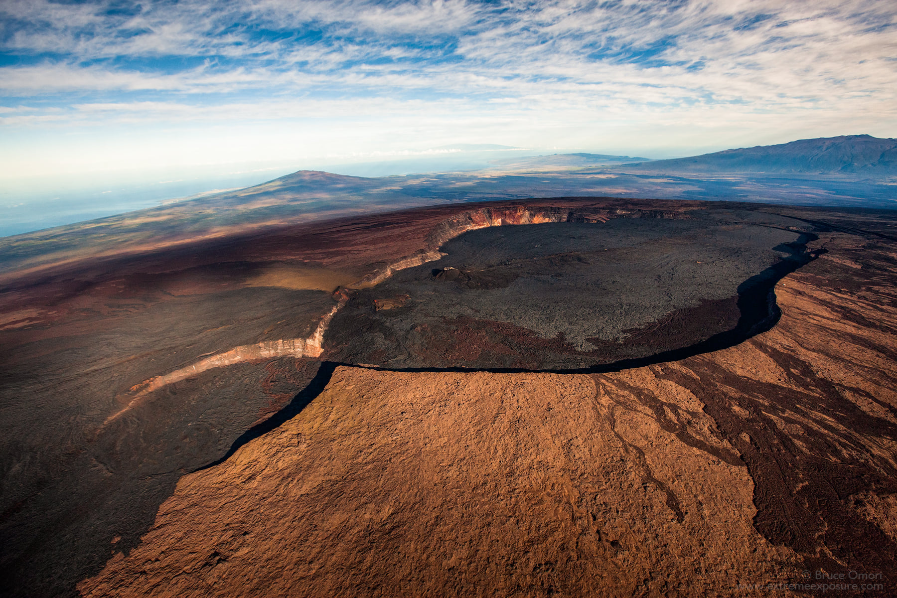
Hawaii , Mauna Loa :
19°28’30 » N 155°36’29 » W,
Summit Elevation 13681 ft (4170 m)
Current Volcano Alert Level: ADVISORY
Current Aviation Color Code: YELLOW
Activity Summary:
Mauna Loa Volcano is not erupting. Rates of seismicity at the summit remain slightly above long-term background levels, but have not changed significantly over the past week. Other monitoring data streams—ground deformation, gas discharge, and visual observations—show no significant changes.
Observations:
During the past week, HVO seismometers recorded 88 small-magnitude earthquakes—all below M3.0—beneath the summit and upper-elevation flanks of Mauna Loa. The majority of these earthquakes occurred at shallow depths less than 8 kilometers (5 miles) below sea level.
Measurements of ground deformation, using Global Positioning System (GPS) instruments, confirm that the surface of the volcano has not moved appreciably over the past week.
Gas concentrations and fumarole temperatures at both the summit caldera and at Sulphur Cone on the Southwest Rift Zone remain stable.
Webcam views have shown no changes to the landscape at the Mauna Loa summit or on the lower flanks of the volcano over the past week.
Source : HVO.
Photo : Bruce Omori .