September 03 , 2021.
Northern Mariana Islands , Pagan :
18°7’48 » N 145°48′ E,
Summit Elevation 1870 ft (570 m)
Current Volcano Alert Level: WATCH
Current Aviation Color Code: ORANGE
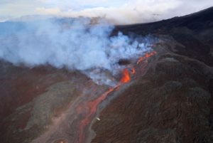
The Aviation Color Code/Volcano Alert level for Pagan Volcano was raised to ORANGE/WATCH earlier today following the observation of low-level emissions from the volcano for most of September 1. After a brief pause in the emissions, a continuous low-level gas and ash plume extending 350 nautical miles from Pagan Volcano was observed in satellite images from this morning indicating that activity is continuing. The Aviation Color Code/Volcano Alert Level remains at ORANGE/WATCH.
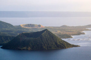
A fissure that formed during an eruption of North Pagan volcano in the Mariana Islands in 1981 cuts across the summit of the volcano. Three principal vents were active along the fissure. A scoria cone (foreground) was constructed at the northernmost vent, and vents on the north and south rims of the summit crater fed lava flows that traveled down the flanks. Blocks as large as 1 m in diameter were ejected to distances of 2 km from the vent. This 16 June 1981 photo shows South Pagan volcano at the upper right.
Mount Pagan is not monitored with ground-based geophysical instrumentation. We will continue to evaluate satellite imagery, distal geophysical data, and mariner reports when available, but because the volcano is not monitored with ground-based instruments, we cannot provide advanced warning of activity.
Source : USGS.
Photo : U.S. Navy, 1981.
Japan , Suwanosejima :
JMA reported that 15 explosions at Suwanosejima’s Ontake Crater produced eruption plumes that rose as high as 3.2 km above the crater rim during 20-27 August. Large volcanic bombs were ejected 300 m from the crater. Crater incandescence was visible nightly and ashfall was often reported in Toshima village (4 km SSW); a large amount of ash fell in the village on 26 August.
At 1231 on 28 August an eruption produced an ash plume that rose 4.8 km above the crater; weather clouds prevented clear views, though observations indicated that the event continued at least through 1700. The Alert Level remained at 2 and the public was warned to stay 1 km away from the crater.
Source: Japan Meteorological Agency (JMA) , GVP
Photo : Taken from a helicopter of Kagoshima Prefecture by JMA
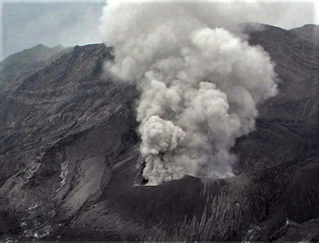
Kamchatka , Karymsky :
54.05 N, 159.44 E;
Elevation 1486 m (4874 ft)
Aviation Colour Code is ORANGE
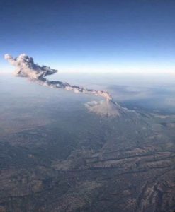
A moderate eruptive activity of the volcano continues. Ash explosions up to 8-9 km (23,000-29,500 ft) a.s.l. could occur at any time. Ongoing activity could affect international and low-flying aircraft.

The explosive eruption of the volcano continues. Explosions sent ash up to 2.5 km a.s.l. on 27 August, 2021.
A moderate eruptive activity of the volcano continues. Satellite data by KVERT showed an ash plumes and clouds extended about 50 km to the north-east and east from the volcano on August 26, 27; a thermal anomaly over the volcano on August 26-28, 31 and September 1-2.
Source : Kvert.
Photo : N. Gorbach, IVS FEB RAS.
Colombia , Nevado del Huila :
Weekly activity bulletin of the Nevado del Huila volcano
The level of activity of the volcano continues at the level:
Yellow activity level or (III): changes in the behavior of volcanic activity.
From the analysis and evaluation of the information obtained through the monitoring network of the Nevado del Huila volcano during the week of August 24 to 30, 2021, the COLOMBIAN GEOLOGICAL SERVICE – Volcanological and Seismological Observatory of Popayán reports that:
During the period evaluated, the seismic activity of the Nevado del Huila volcano remained stable. The network of seismic stations recorded 164 events, of which 83 were related to rock fracturing processes (type VT) and 81 to fluid dynamics inside volcanic conduits. Of these, 76 were classified as long period type events (LP type), one (1) hybrid type event (HB) and four (4) as low energy tremor pulses (TR type).
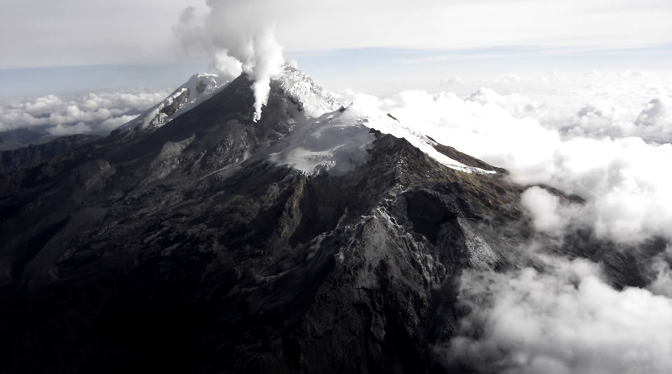
On August 30, a mobile SO2 measurement was carried out on the Pan-American Highway, on the Tunía (Cauca) and Cali (Valle del Cauca) roads. The calculated flow was 971 t / day, with a column that dispersed towards the west side of the Nevado del Huila volcano.
In the images obtained during the week by the web cameras of Caloto, Maravillas, La Palma and Tafxnú, a low level of outgassing of the volcanic system was observed.
The sensors monitoring soil deformation, magnetic fields and infrasound waves, did not record variations associated with changes in volcanic activity.
Therefore, it is concluded that during the evaluated period, the volcano continued to exhibit stable behavior. The Colombian Geological Service continues to monitor the evolution of the volcanic phenomenon and will inform in due course of any changes that may occur.
Source : SGC.
Photo : Parque Nacional.
Iceland , Skaftá River. :
Glacial Outburst Flood Likely Begun in Skaftá
Electrical conductivity readings from the Skaftá river have increased and water levels by Sveinstindur have increased this morning, signifying that a glacial outburst flood is in progress. It is likely that the flood originated from the western Skaftá ice cauldron which last drained in 2019, although it is not impossible that a flood from the eastern cauldron might follow.
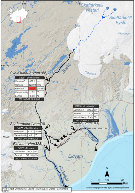
In addition to rising water levels and increased electrical conductivity, the Iceland Meteorological Office has also been notified of sulfuric smell in the area around Skaftá and Hverfisfljót. It is believed that the changes are not due to melting glaciers or rain, but rather that a glacial outburst flood has begun. Data suggests that the flood origin is in the western ice cauldron in the Vatnajökull glacier, which last flooded in September 2019. The western ice cauldron usually produces smaller floods than the eastern one.
The flow of Skaftá by Sveinstindur was around 290 m3/s at noon today but the Met Office doesn’t expect the maximum flow during this flood to surpass 750 m3/s. However, there is a possibility that water drains from the eastern ice cauldron on the heels of the current flood from the western one, as happened in August 2018.

It’s important that everyone who is travelling in the flood area is conscious of the situations that can arise and that travellers are well informed of the situations:
Flood conditions are expected in Skaftá over the next two to three days. Some flooding of unpaved roads close to Skaftá is possible.
Hydrogen sulphide is released from the floodwater as it drains from the Vatnajökull ice-cap. The gas is particularly potent at the ice margin, where concentrations will reach poisonous levels. Travellers must stay away from the edges of Skaftárjökull, Tungnaárjökull and Síðujökull while the flood occurs.
Crevasses will develop rapidly around the ice cauldron, so travellers on Vatnajökull should stay away from the region, including the lower part of Skaftárjökull and Tungnaárjökull, where floodwater could burst through the surface.
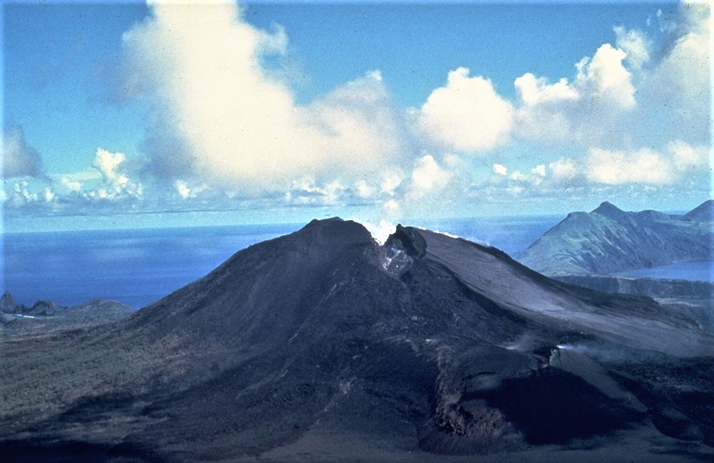
Floods in Skaftá are sourced from two ice cauldrons, formed due to persistent geothermal activity beneath Vatnajökull. On average, the cauldrons drain every two years, producing floods of up to 1,500 cubic metres per second. When the interval between floods is short, the flood tends to be smaller. The eastern cauldron is responsible for the largest floods. The river has flooded at least 58 times since 1955, with each cauldron usually draining at a two-year interval.
Source : Vedur Is , icelandreview.com
Photos : Vedur is , Páll Stefánsson.