May 18 , 2021.
Philippines , Taal :
TAAL VOLCANO ADVISORY 18 May 2021 08:30 A.M.
This is a notice of elevated unrest at Taal Volcano.
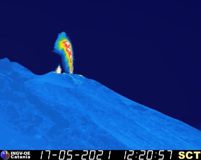
In the past 24 hours, Taal Volcano’s monitoring network recorded two hundred eighty-eight (288) volcanic earthquakes, including thirty-nine (39) low frequency volcanic earthquakes and two hundred forty-nine (249) volcanic tremor events having durations of one (1) to twenty (20) minutes, and low-level background tremor that has persisted since 08 April 2021. Most of these earthquakes were very shallow and generated within five (5) kilometers beneath Taal Volcano Island or TVI and northeast Taal Lake. Upwelling of hot volcanic fluids in the Main Crater Lake and active degassing from fumaroles on the Main Crater that produced 300-meter-tall steam-laden plumes were observed since daybreak. Sulfur dioxide (SO2) emission averaged 2,214 tonnes/day on 17 May 2021. Electronic tilt monitoring recorded a slight but very abrupt inflation of Taal Volcano Island that began yesterday, while longer-term ground deformation parameters from electronic tilt, continuous GPS and InSAR monitoring continue to record a very slow and steady inflation and expansion of the Taal region that began after the January 2020 eruption. These parameters indicate persistent magmatic activity at shallow depths beneath the edifice.
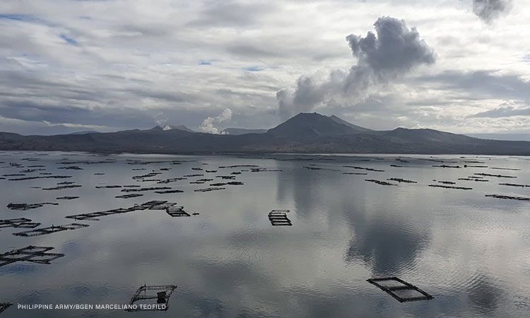
Alert Level 2 (Increased Unrest) is currently maintained over Taal Volcano, but elevated unrest has been recurring and volcano conditions remain unstable. DOST-PHIVOLCS reminds the public that at Alert Level 2, sudden steam-driven or phreatic explosions, volcanic earthquakes, minor ashfall, and lethal accumulations or expulsions of volcanic gas can occur and threaten areas within and around TVI. DOST-PHIVOLCS strongly recommends that entry must be strictly prohibited into Taal Volcano Island, Taal’s Permanent Danger Zone or PDZ, especially the vicinities of the Main Crater and the Daang Kastila fissure, and occupancy and boating on Taal Lake. Local government units are advised to continuously assess and strengthen the preparedness of previously evacuated barangays around Taal Lake in case of renewed unrest. Civil aviation authorities must advise pilots to avoid flying close to the volcano as airborne ash and ballistic fragments from sudden explosions and wind-remobilized ash may pose hazards to aircraft. DOST-PHIVOLCS is closely monitoring Taal Volcano’s activity and any new significant development will be immediately communicated to all stakeholders.
Source : Phivolcs.
Photo : CNNPH , marcello Teofilo
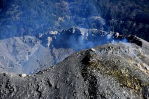
Italy , Stromboli :
PRESS RELEASE ON THE ACTIVITY OF STROMBOLI, May 17, 2021, 15:24 (13:24 UTC)
The National Institute of Geophysics and Volcanology, Osservatorio Etneo, announces that the average amplitude of volcanic tremor is at medium-high values, as reported in the Stromboli Activity press release of 05/11/2021. Regarding the amplitude of the VLP signals, no variation is observed and it remains at low levels.
At the same time, the amplitude of explosion earthquakes remains low and sometimes medium-low.
A discontinuous projection activity continues to be observed in the North crater, which is sometimes more intense. At approximately 11:45 UTM and 11:55 UTM, more intense explosive episodes were observed in the Center-Sud sector.
The inclinometric and GNSS surveillance networks do not currently show significant changes. At 6:21 a.m. on May 15, there is a change in the TDF (Timpone del Fuoco) inclinometer with maximum values of around 2 microradians.
PRESS RELEASE ON THE ACTIVITY OF STROMBOLI, May 17, 2021, 16:56 (14:56 UTC).
The National Institute of Geophysics and Volcanology, Osservatorio Etneo, announces that the amplitude of the volcanic tremor has reached medium-low values, confirming the oscillating trend between the medium-low and medium-high values observed in recent days.
At the same time, the amplitude of VLP signals and explosion earthquakes remains low.
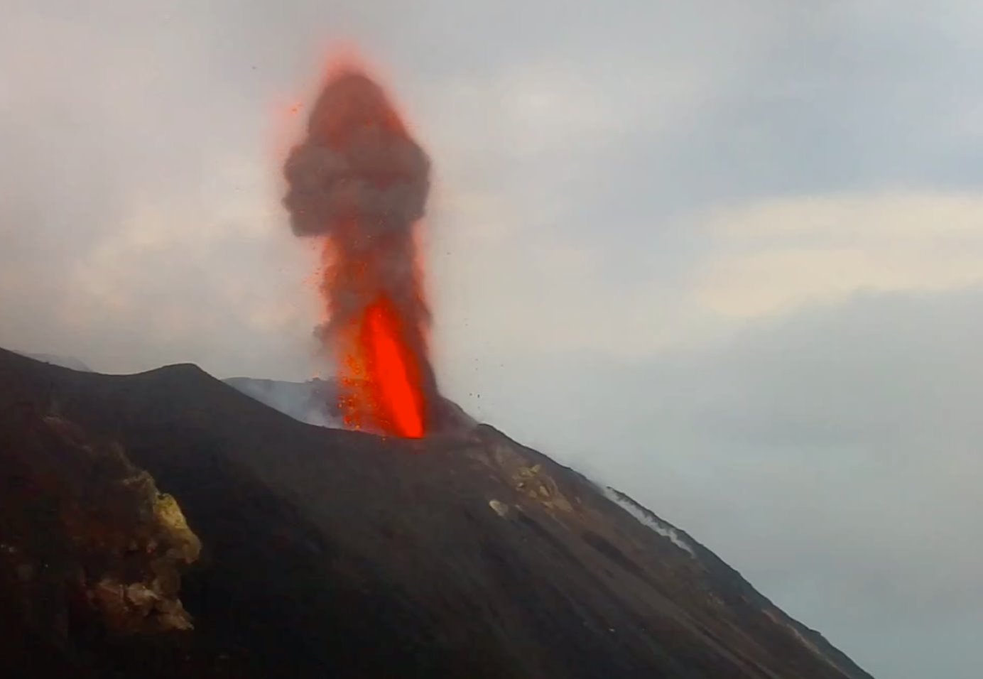
The projection activity remained virtually unchanged. Starting at 13:00 UTC and for about an hour, a slight increase in intensity and frequency was observed in the individual explosions in both the North and Center-South sectors.
There is no significant change in the time series of soil deformation monitoring networks
Further updates will be communicated shortly.
Source : INGV.
Read the article : https://www.ct.ingv.it/Dati/informative/vulcanico/ComunicatoSTROMBOLI20210517130451.pdf
Photos : INGV , web cam skynet
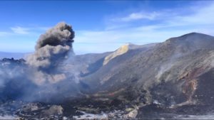
La Réunion , Piton de la Fournaise :
Press release of May 17, 2021 – 11:00 a.m.
The eruption that started on 04/09/2021 at 7 p.m. (appearance of the tremor) continues. The amplitude of the volcanic tremor (indicator of a surface lava emission) continues its slow decrease initiated
since May 2.
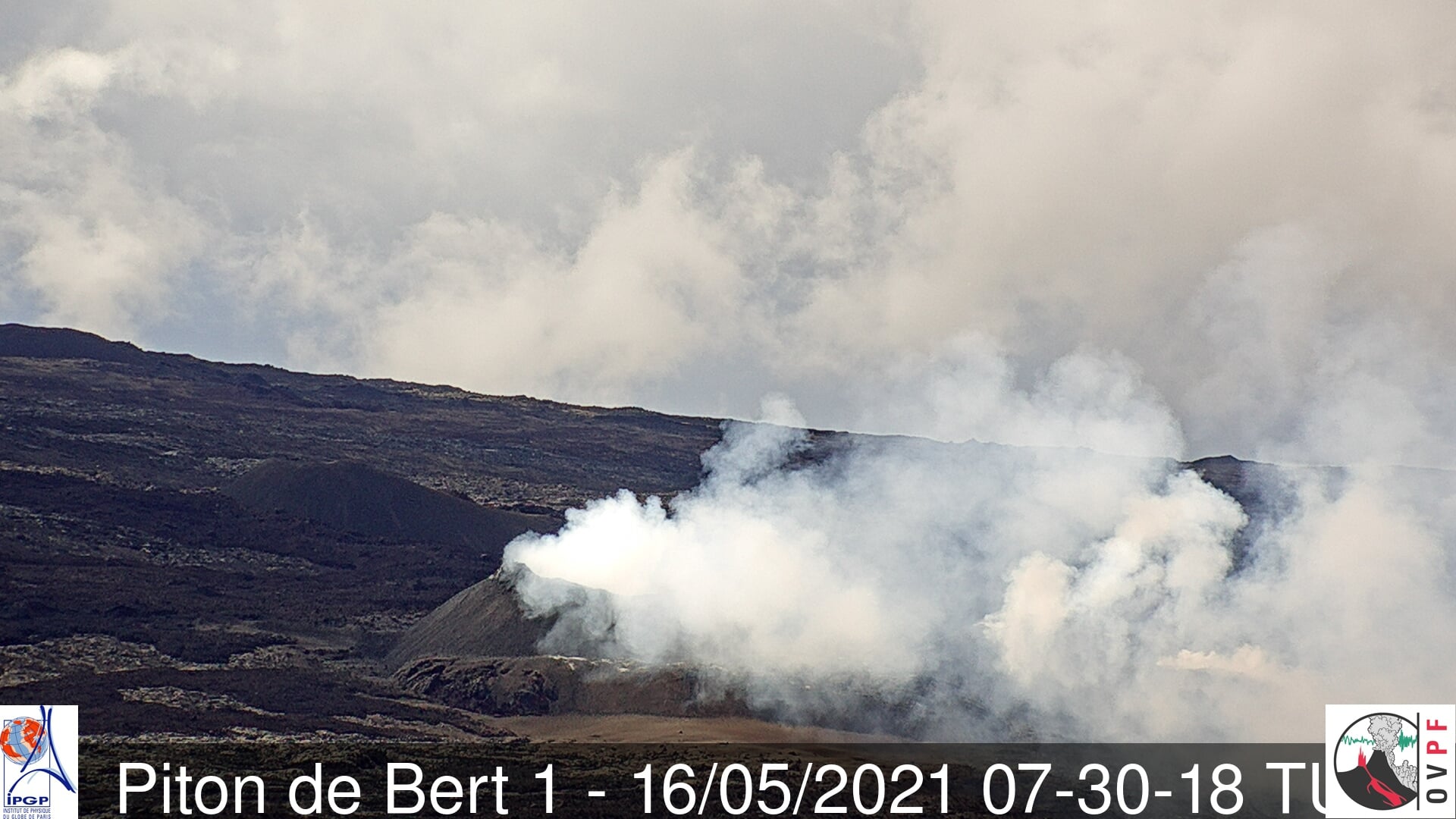
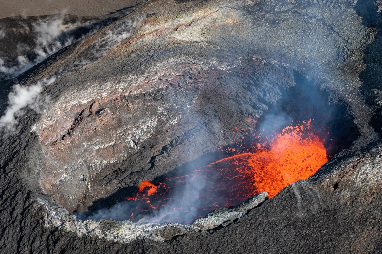
– The images from the OVPF and OVPF / IRT cameras over the last 24 hours show that:
• the two cones are still active with strong degassing;
• the flow of lava at the exit of the eruptive vents, mainly takes place in tunnels up to the upper limit of the large slopes, where resurgences of lava are sometimes visible on the surface;
• the flow front progresses only very slowly on the Grandes Pentes.
– Over the last 24 hours, 2 superficial volcano-tectonic earthquakes (between sea level and the surface) have been recorded, located directly above the summit craters.
– The CO2 fluxes in the soil are always increasing in the far field (Plains region).
– A slight inflation trend in the summit area is again recorded.
– The observations made in the field on 11/04 and the analyzes of the eruptive products show the presence of the emission of a poorly degassed magma at the start of the eruption. Sampling on 05/03 revealed the arrival at the surface of new, warmer magma, which may correspond to the deep source of magma that pressurized the more shallow magma emitted at the start of the eruption.
Lava flows can be estimated from SO2 flows measured by the DOAS “NOVAC” network. Considering a partially degassed magma during the first days of the eruption, the
maximum lava flow probably did not exceed 20 m3 / s on 9 and 10/4. The proportions of less degassed magma then probably increased over time allowing estimate an average flow of 24 m3 / s for the day of 13/4 (but with maximum values probably going up to 59 m3 / s), then a lower average flow between 8.3 and 1.2 m3 / s for the period from 16 to 22/4. Following the failure of the Bert station (located at Piton de Bert), flows were estimated by the Enclos station (located on the western edge of the Enclos ) from 04/24. Data from the Enclos station seem to suggest a relatively weak and stable flow of gas and magma since 4/27. A significant variation in SO2 flux was nevertheless detected on 12/5, probably resulting in a punctual increase in the lava flux emitted at the surface. On the other hand, no estimate of the lava flow could be established by the HOTVOLC platform (OPGC – Clermont Auvergne University), because the lava flow now almost entirely in a tunnel considerably limits the thermal radiation of the flow.
Niveau d’alerte : Alerte 2-2
Source : OVPF.
Read the article : https://www.ipgp.fr/sites/default/files/ovpf_20210517_11h00_communique_eruption.pdf
Photos : OVPF , Sag / Pghm / Ovpf ( 02 Mai).
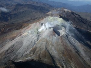
Peru , Sabancaya :
Analysis period: May 10, 2021 to May 16, 2021, Arequipa, May 17, 2021.
Alert level: ORANGE
The Geophysical Institute of Peru (IGP) reports that the eruptive activity of the Sabancaya volcano remains at moderate levels, that is to say with the recording of an average of 37 daily explosions, with columns of ash and gas up to 3.5 km altitude above the summit of the volcano and their consequent dispersion. Therefore, for the following days, no significant change is expected in eruptive activity.
The IGP recorded and analyzed the occurrence of 733 earthquakes of volcanic origin, associated with the circulation of magmatic fluids within the Sabancaya volcano. An average of 37 explosions was recorded daily. During this period, Volcano-Tectonic (VT) earthquakes associated with rock fractures were located mainly in the West, East, and North-West of Sabancaya and presented magnitudes between M1.0 and M3.8.

The monitoring of the deformation of the volcanic structure using GNSS techniques (processed with fast orbits) does not present any significant anomalies. However, in general, an inflation process was observed in the northern sector (around the Hualca Hualca volcano). Visual surveillance made it possible to identify columns of gas and ash up to 3.5 km altitude above the summit of the volcano, which were scattered towards the South-East, South, East and North-East sectors of the volcano. Sabancaya. Satellite recordings have identified the presence of 8 thermal anomalies (maximum value of 14 MW) associated with the presence of a lava body on the surface of the volcano’s crater. The civil defense of the province of Caylloma reports light ash falls in the district of Chivay and in Achacota.
RECOMMENDATIONS
• Keep the volcanic alert level in orange.
• Do not approach within a radius of 12 km from the crater.
Source : IGP.
Photo : Andina.
Saint Vincent , Soufrière Saint Vincent :
La Soufriere Volcano – SCIENTIFIC UPDATE 17/05/21 6:00PM
– Seismic activity at La Soufrière, St Vincent has remained low since the tremor associated with the explosion and ash venting on 22 April.
– In the last 24 hours, only a few long-period earthquakes have been recorded.
– When the cloud is high enough, there is persistent steaming observable from the observatory.
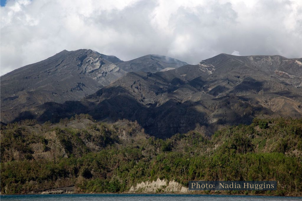
– Thermal anomalies, indicating high temperatures inside the new crater, continue to be detected by the NASA FIRMS alert system.
– The volcano continues to be in a state of unrest. Escalation in activity can still take place with little or no warning.
– Caution should be taken in traversing river valleys on the volcano due to the increased risk of lahars (mudflows) during periods of rainfall on the volcano.
– The volcano is at alert level ORANGE.
Source : UWI.
Photo : Nadia Huggins / UWI