May 14 , 2021.
La Réunion Island , Piton de la Fournaise :
Press release of May 13, 2021 – 1:15 p.m.
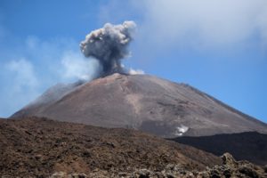
The eruption that started on 04/09/2021 at 7 p.m. (appearance of the tremor) continues. The amplitude of the volcanic tremor (indicator of a surface lava emission) continues its slow decrease initiated since May 2.
– The images from the OVPF and OVPF / IRT cameras over the past 24 hours, as well as the images taken by SAG and PGHM during an overflight yesterday around 3:30 p.m. show that:
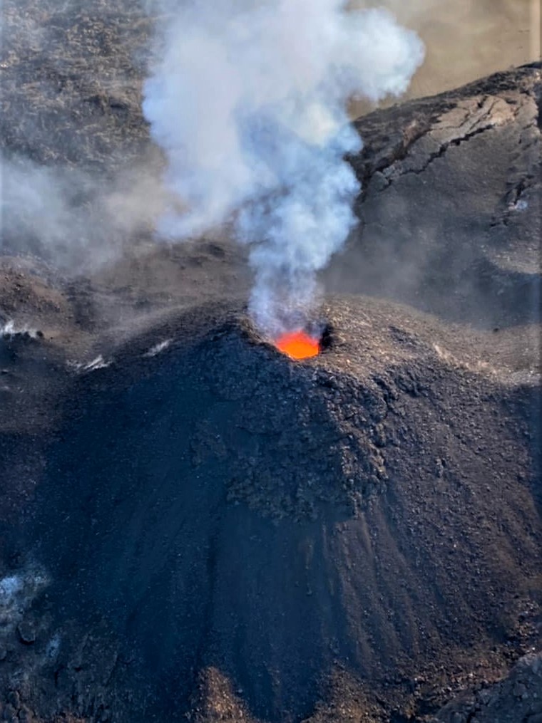
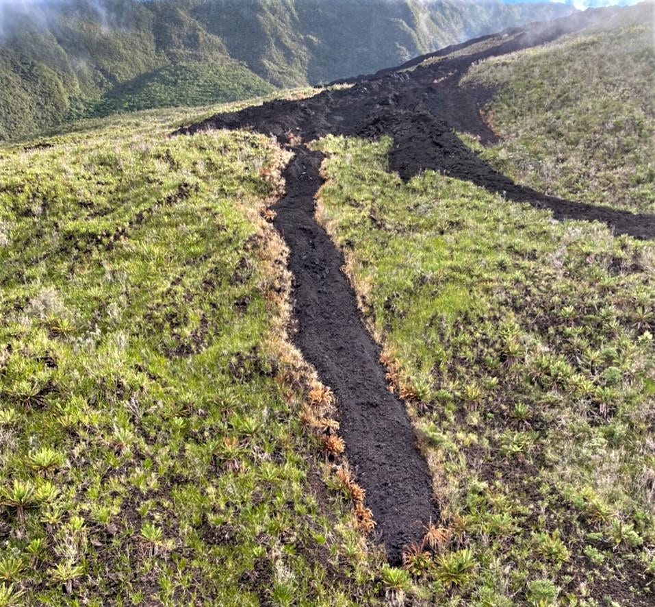
• the two cones are always active with a strong degassing. The lava level in the two cones is now very low, and the most downstream cone has closed considerably compared to the day of May 11. The most downstream cone projects lava fountains at 5 minute intervals to a height of 5-6 m above the cone.
• the flow of lava at the exit of the eruptive vents, occurs mainly in tunnels up to the upper limit of the large slopes, where resurgences of lava are sometimes visible on the surface.
• the flow front continues its slow progression in the Grandes Pentes, it was yesterday around 3:30 pm at an altitude of 920 m.
Over the past 24 hours, 4 superficial volcano-tectonic earthquakes (between sea level and the surface) have been recorded, all located directly above the summit craters.
– The CO2 fluxes in the soil are always increasing in the far field (Plains region).
– Over the last 48 hours, no significant deformation has been recorded.
– No estimate of lava flow could be established by the HOTVOLC platform (OPGC – Clermont Auvergne University), because the lava flow now almost entirely in a tunnel considerably limits the thermal radiation of the flow.
Alert level: Alert 2-2.
Source et photos : OVPF
Read the article : https://www.ipgp.fr/sites/default/files/ovpf_20210513_13h15_communique_eruption.pdf
Saint Vincent , Soufrière Saint Vincent :
Soufrière St. Vincent SCIENTIFIC UPDATE – 12/05/21 6:00PM
– Seismic activity at La Soufrière, St Vincent has remained low since the tremor associated with the explosion and ash venting on 22 April.
– In the last 24 hours, seismic activity was limited to a few long-period earthquakes.
– Gas measurements on May 11 yielded an average SO2 flux of 252 tons per day.
– The volcano continues to be in a state of unrest. Escalation in activity can take place with little or no warning.
– Caution should be taken in crossing river valleys on the volcano due to the increased risk of lahars (mudflows) during periods of rainfall on the volcano.
– The volcano is at alert level ORANGE.
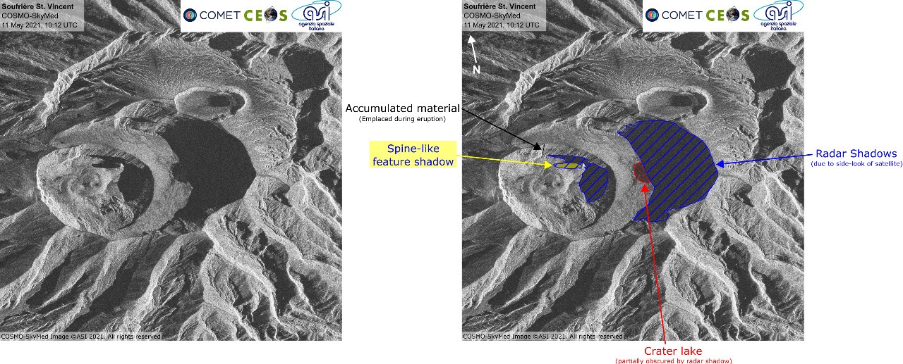
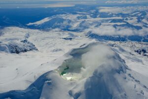
Satellite images reveal features within the 2021 crater of LaSoufriere volcano which appear to be mainly rubble. The pattern visible (round features) probably reflect the morphology of the rubble (i.e. slumps, depressions and mounds). At this stage, scientists cannot say for sure that there are no vents, however there are no clear features in these images that look definitively like a dome or vent. The source of the gas plume remains unclear.
Source : UWI.
Hawaii , Kilauea :
19°25’16 » N 155°17’13 » W,
Summit Elevation 4091 ft (1247 m)
Current Volcano Alert Level: WATCH
Current Aviation Color Code: ORANGE
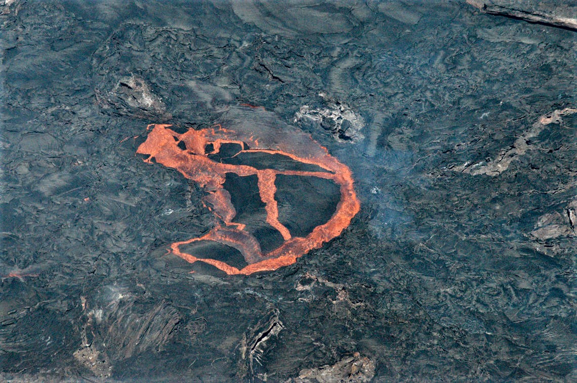
A telephoto view of the active lava surface in Halema‘uma‘u at the summit of Kīlauea. While less frequent than previous weeks, crustal foundering on the active surface of the lava lake persists. Field crews observed this foundering event on Monday afternoon, May 10. It only lasted a few minutes and was approximately 30 m (100 ft) across.
Activity Summary:
This morning, May 13, the lava lake was 229 m (751 ft) deep and remains stagnant over its eastern half. SO2 emission rates remain elevated at 225 t/day, last measured on May 12.
Summit Observations:
The most recent sulfur dioxide emission rate, measured on May 12, was 225 t/day and continues a trend of decreased emission rates that began in mid-April. This remains elevated compared to rates (less than 100 t/day) in the months before the summit lava lake eruption started on December 20, but is significantly lower than emission rates that averaged over 800 t/day from mid-February to mid-April. Summit tiltmeters recorded minor change over the past 24 hours. Seismicity remains stable, with elevated tremor.
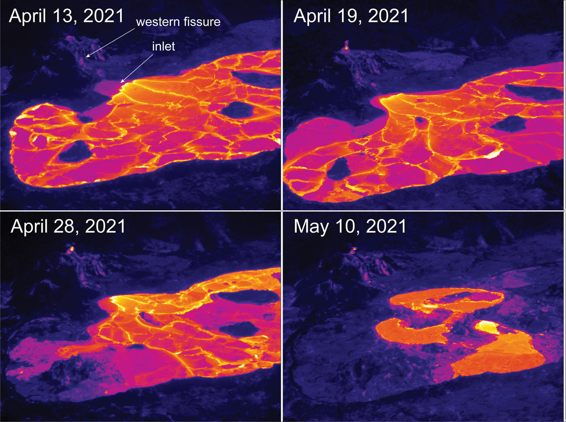
This thermal image comparison shows the diminishing area of active surface lava over the past month in Halema‘uma‘u, at the summit of Kīlauea Volcano. Over this time period, the activity has transitioned from a small lava lake to a series of weak surface flows near the western inlet.
Halemaʻumaʻu Lava Lake Observations:
Lava effusion from the west vent continues to supply the lava lake within Halema‘uma‘u crater through a submerged inlet to the lake. Lava circulation and intermittent foundering of crust continue in a smaller western portion of the lava lake, and lava has not oozed out along the perimeter of the lake over the past week. The total depth of the lake is 229 m (751 ft) this morning as measured by a continuous laser rangefinder on the active western portion. Stagnant and solidified lava crust covered 93% of the lake surface as measured by thermal mapping on April 16th.
Recent SO2 emission rate measurements suggest that the effusion (eruption) rate has decreased significantly since mid-April.
Source : HVO.
Photos : USGS / B. Carr , USGS / M. Patrick.
Costa Rica , Turrialba / Poas / Rincon de la Vieja / Irazu :
Weekly bulletin of the volcanic watch program, May 10, 2021.
Turrialba volcano
Lat: 10.025 ° N; Long: 83.767 ° W;
Altitude: 3340 m.s.n.m.
Current activity level: 2 (active volcano)
Potentially associated hazards: gas, ash emission, proximal ballistic projections, acid rain, lahars, pyroclastic density currents.
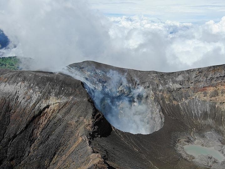
No eruption was observed. The seismicity remains similar to the previous weeks, with a slight increase in the daily number of low-frequency type earthquakes, but without it being significant. The daily number of tremors returned to normal after a slight decrease and the occurrence of 2 « long period » type earthquakes. The contraction and subsidence of the massif monitored by the geodetic network continues gradually. The gas ratios remain stable, 22.72 +/- 2.15 for CO2 / SO2 and 0.22 +/- 0.02 for H2S / SO2.
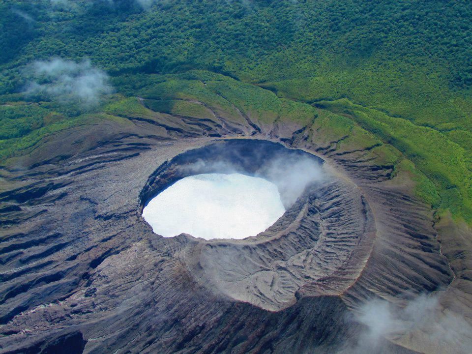
Poas volcano
Lat: 10.2 ° N; Long: 84.233 ° W;
Altitude: 2780 m.s.n.m.
Current activity level: 2 (active volcano)
Potentially associated hazards: gas, phreatic eruptions, proximal ballistic projections, lahars, acid rain.
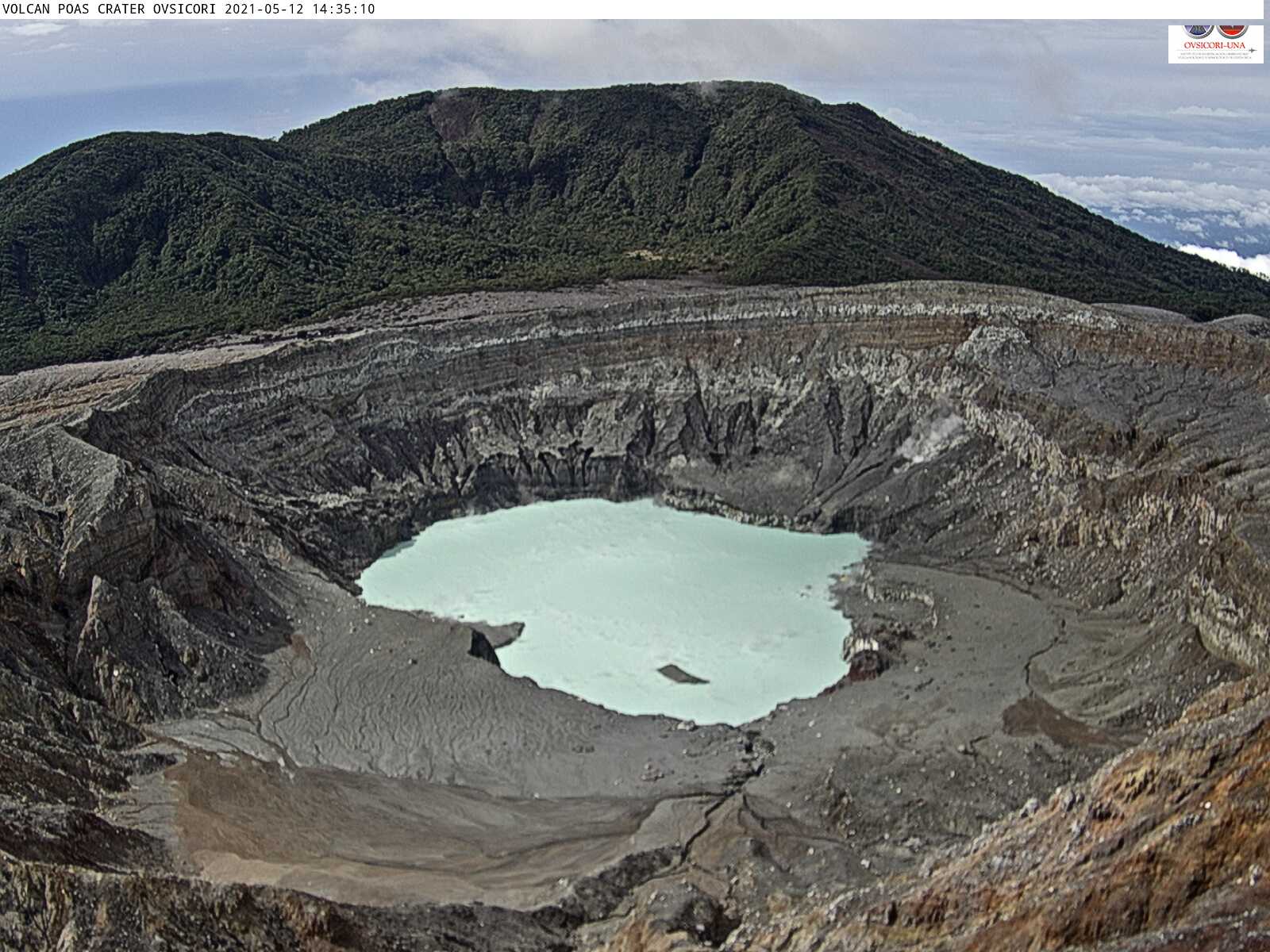
No éruption was observed. The seismic records have returned to normal levels, similar to those of a few weeks ago. RSAM (and DSAR) declined after peaking in the past 2 weeks. The harmonic tremor changed frequency at the end of the period of the most intense seismic activity. Geodetic monitoring continues to a small extent, without acceleration. Gas ratios are stable at normal values (weekly average SO2 / CO2: 0.45 +/- 0.15; weekly average H2S / SO2: 0.45 +/- 0.04). The SO2 concentration in the vent remained below 1.5 ppm during the week. The level of the hyperacid lake remains stable.
Rincon de la Vieja volcano
Lat: 10.83 ° N; Long: 85.324 ° W;
Altitude: 1895 m.s.n.m.
Current activity level: 2 (active volcano)
Potentially associated hazards: lahars, gas, phreatic eruptions, proximal ballistic projections, ash.
No eruption has been observed since the beginning of December 2020. The seismic activity continues to decrease, with a decrease in the amplitude of the « tornillo » type events recorded. The tremor has decreased in amplitude, which implies an attenuation of the high frequencies. Geodetic monitoring shows a slight trend of contraction which will be confirmed in the coming weeks.
Irazu volcano
Lat: 9.979 ° N; Long: 83.852 ° W;
Altitude: 3432 m.s.n.m.
Current activity level: 1 (active volcano)
Potentially associated hazards: landslides, lahars, proximal ballistic projections, acid rain, ash falls, debris avalanches.
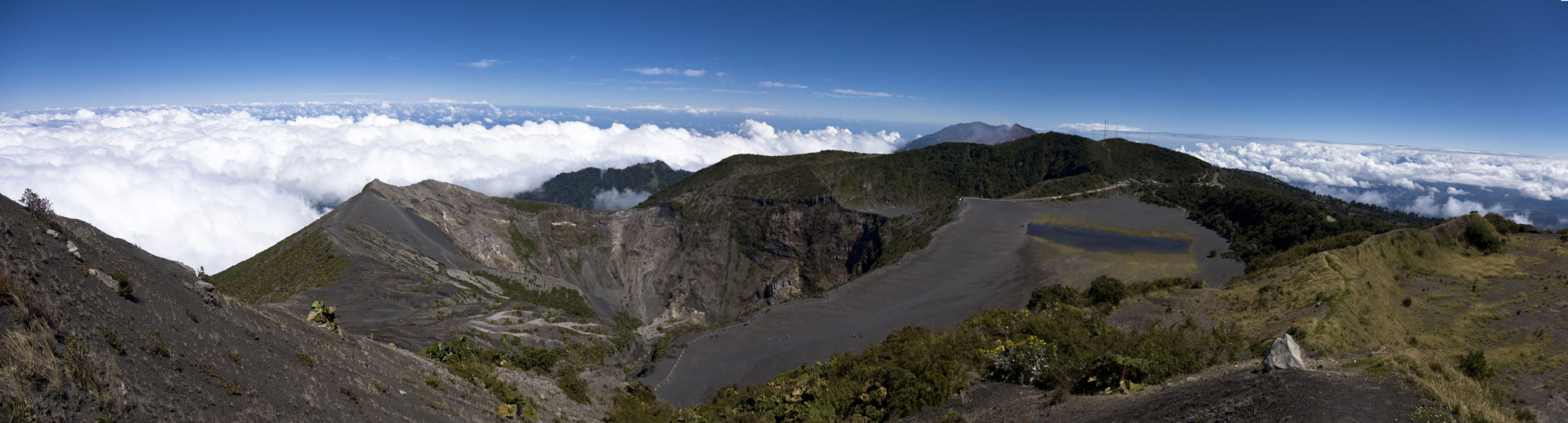
Nearly a dozen distal VT-type earthquakes were recorded between May 9 and May 10, in particular a small swarm northwest of the volcano in what could be the Patillos fault. There were also 4 small landslides, particularly on May 7th. The speed of the main landslide in the communications tower area remains constant despite the rains last month. The slight increase in CO2 concentration observed last week has been confirmed, but is not yet significant. The main crater remains dry without the crater lake forming again, despite the climatic influence of a “moderate Niña” between the years 2017-2021.
Source : Ovsicori.
Photos : G. Avard / Ovsicori , Ovsicori , Raul Mora / RSN / UCR , Rafael Golan / wikipedia.