May 6 , 2021 .
Iceland , Geldingadalur / Fagradalsfjall :
No evidence that the eruption stops.
Recent changes in eruptive behavior at Fagradalsfjall, where either high jets of magma emerge from the crater or eruptive activity slows down, do not appear to have had a significant effect on the lava flow, at least not yet, according to the researchers final measurements of the flow by the University of Iceland.
The lava flow last week averaged 7.5 cubic meters per second. The flow was slightly higher but similar to the previous week. The Institute of Earth Sciences says there is no sign the eruption is stopping.
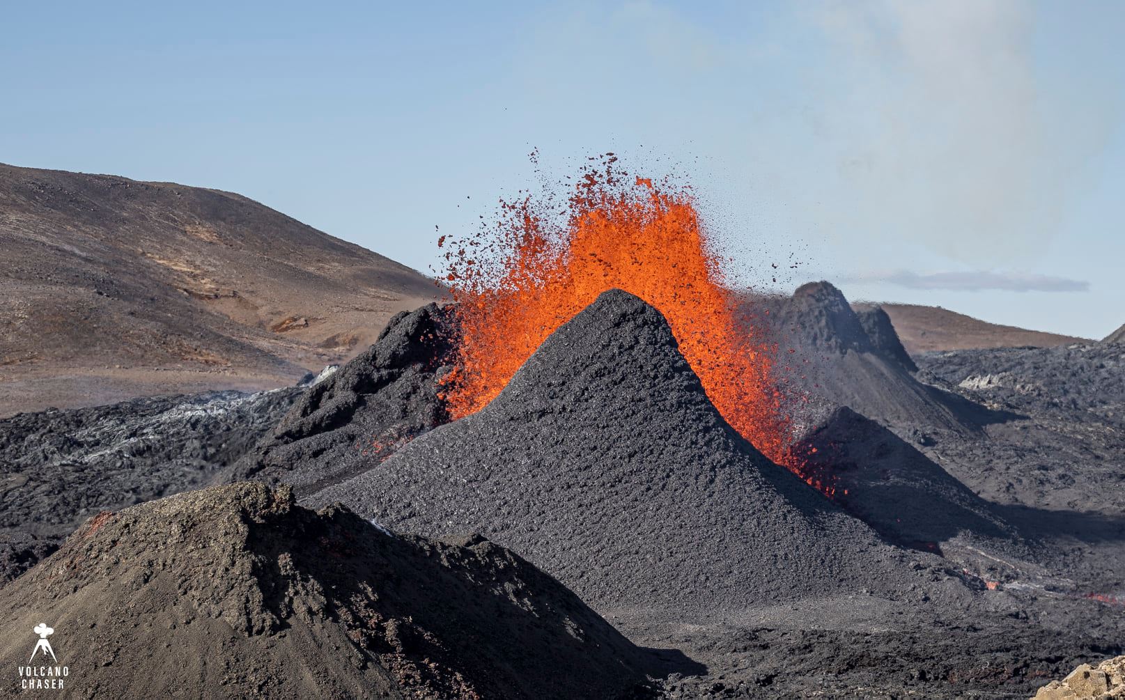
The volume of the eruption has now reached 23 million cubic meters, and the lava area is 1.41 square kilometers. The biggest change last week is located in the depression between Stórahrút and the hills east of Geldingadalur and in the lava spit up to Meradalur.
It is not possible to say how long the eruption could last, but the development of lava flows can be expected to indicate in the future.
« A comparison with other eruptions shows that the flow is similar to what was longest at Surtsey after the lava eruption that began there in April 1964 until the eruption ended in June 1967. The eruptions are not entirely comparable, as in the first weeks of the Surtsey eruption the flow of magma to the surface was several times greater. The flow at Geldingadalur is about 5% of the average flow at Holuhraun during the six months that the eruption lasted, from September 2014 to the end of February 2015 ”, indicates the website of the Institute of Earth Sciences.
Source : RUV.
Photo : Volcano chaser / Marc Szeglat
Saint Vincent , Soufrière Saint Vincent :
University of the West Indies Seismic Research Centre (UWI-SRC) reported that seismicity at Soufrière St. Vincent (often simply referred to as “La Soufriere”) remained low during 28 April-4 May, with a few long-period, hybrid, and volcano-tectonic earthquakes recorded daily. Multiple significant lahars were generated by rainfall during 28-29 April. Lahars likely descended all valleys in the Red and Orange zones, and some were hot and visibly steaming. Trees brought down by lahars were swept to the sea; floating logs created hazardous conditions for small boats along the coastline. UWI-SRC and the National Emergency Management Organisation (NEMO) both warned the public to stay away from drainages and areas prone to flooding, and noted that lahars have caused notable erosion and damage to drainages and parts of the coastline. Smaller lahars were recorded during the mornings of 30 April and 1 May. Multiple lahars were detected in likely all the volcano’s drainages for a period of about six hours on 3 May, with the most intense lahars occurring during 1100-1200. Sulfur dioxide emissions were measured from a boat near the W coast, yielding a flux of 1,036 tons per day. Photos showed people in Sandy Bay shoveling off ash from rooftops on 4 May. The volcano Alert Level remained at Red.
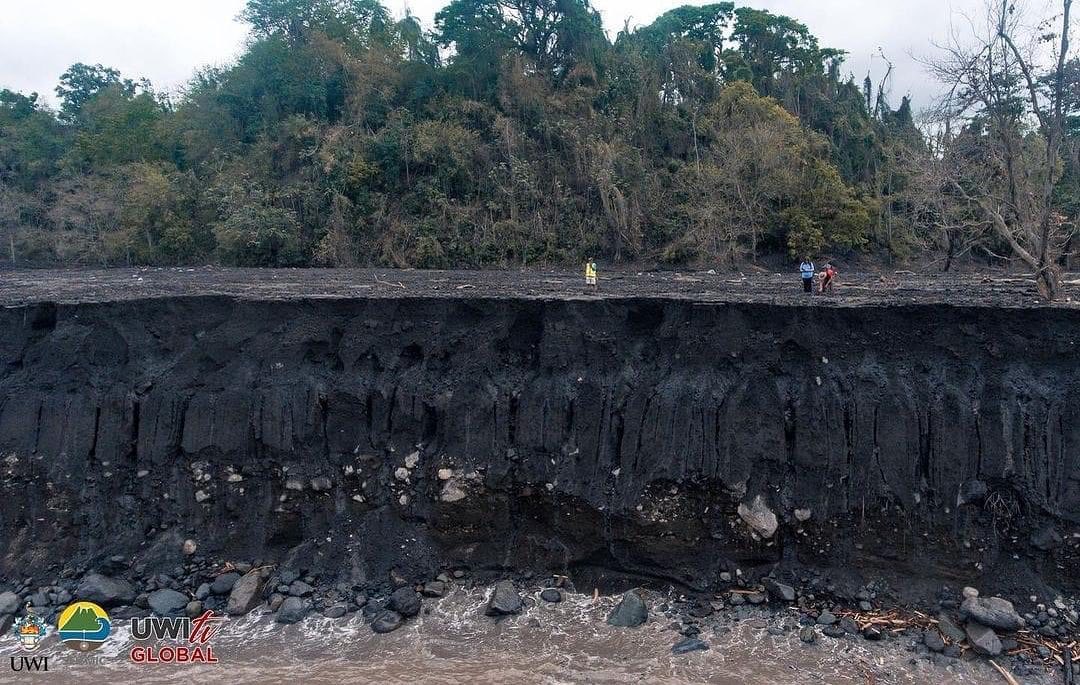
“This is the new 40 foot high river Bank of the Wallibou River. Look closely there are 3 people standing on it.”
La Soufriere St. Vincent, – SCIENTIFIC UPDATE 05/05/21 6:00PM
– Seismic activity at La Soufrière has remained low since the tremor associated with the explosion and ash venting on 22 April.
– In the last 24 hours, only a few long-period, hybrid and volcano-tectonic earthquakes have been recorded and there was no further seismic tremor.
– The volcano continues to be in a state of unrest.
– Explosions with accompanying ashfall, of similar or larger size to those that have already occurred in this eruption, can take place with little or no warning.
– Caution should be taken in crossing river valleys on the volcano due to the increased risk of lahars (mudflows) during periods of rainfall on the volcano.
– The volcano is at alert level RED.
Sources : GVP , UWI.
Japan , Sakurajima :
JMA reported that during 26 April-3 May incandescence from Minamidake Crater (at Aira Caldera’s Sakurajima volcano) was visible nightly. There was a total of 10 explosions, producing ash plumes that rose as high has 2.4 km above the summit and ejected bombs 1.3-1.7 km away from the crater. The Alert Level remained at 3 (on a 5-level scale), and residents were warned to stay 2 km away from the crater.
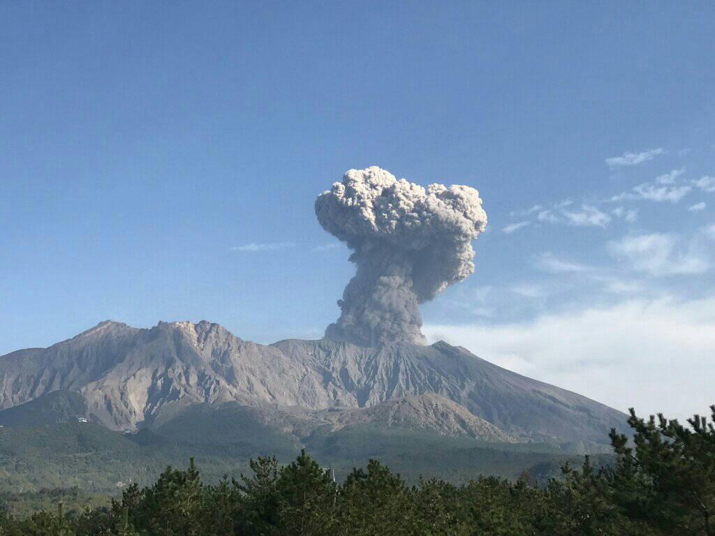
The Aira caldera in the northern half of Kagoshima Bay contains the post-caldera Sakurajima volcano, one of Japan’s most active. Eruption of the voluminous Ito pyroclastic flow accompanied formation of the 17 x 23 km caldera about 22,000 years ago. The smaller Wakamiko caldera was formed during the early Holocene in the NE corner of the Aira caldera, along with several post-caldera cones. The construction of Sakurajima began about 13,000 years ago on the southern rim of Aira caldera and built an island that was finally joined to the Osumi Peninsula during the major explosive and effusive eruption of 1914. Activity at the Kitadake summit cone ended about 4850 years ago, after which eruptions took place at Minamidake. Frequent historical eruptions, recorded since the 8th century, have deposited ash on Kagoshima, one of Kyushu’s largest cities, located across Kagoshima Bay only 8 km from the summit. The largest historical eruption took place during 1471-76.
Source : GVP.
Photo : Rizal M.
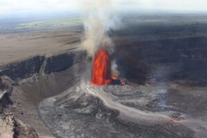
Guatemala , Pacaya :
Activity:
The Pacaya Volcano Observatory reports that due to weather conditions, visibility to the volcano has been limited, only white outgassing is observed at the height of Mackenney crater, but no explosion or rumbling or other noise is heard. In the crack of the northwest flank, the expulsion of incandescent material is sometimes observed at low altitude, and the lava flow that comes out of this crack continues to advance slowly towards the West, over a length of about 2100 meters. with its front located to the south of the area known as La Breña. Detachments of glowing blocks continue to occur throughout the flow, especially where the slope is greater. The seismic stations around the volcano record internal tremors, associated with the movement of magma inside the volcanic building and with periods of outgassing in the crater.
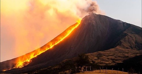
INSIVUMEH reported that during 27-29 April occasional explosions at Pacaya’s Mackenney Crater ejected incandescent material as high as 250 m above the summit. On 27 April a lava flow emerged from a new fissure on the upper SE flank traveled 200 m. At around 0500 on 29 April the seismic network recorded signals indicating a change from mostly explosive to mostly effusive activity. At around 0645 a new fissure opened on the N flank, producing a lava flow that rapidly traveled N towards Cerro Chino and then turned S and spread W and SW. Explosive activity at the fissure was minor during 29-30 April. By 3 May the flow was almost 2.1 km long, and continued to advanced W and SW at least through 4 May.
Source : Insivumeh , GVP.
Photo : Ultramix TV
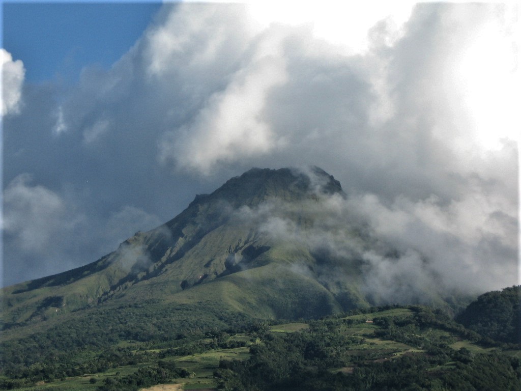
La Martinique Island , Montagne Pelée :
Weekly report on the activity of Mount Pelée for the period from April 23 to 30, 2021.
Seismicity of volcanic origin has increased sharply over the past week. Between April 23, 2021 at 4:00 p.m. (UTC) and April 30, 2021 at 4:00 p.m. (UTC), the OVSM recorded
at least 312 volcano-tectonic earthquakes of magnitude less than or equal to 1.0, including 241 between April 27 and 29 with nearly 163 earthquakes on April 28. These earthquakes were located inside the volcanic edifice between 3.0 km below sea level and 1 km above sea level. None of these earthquakes were felt by the population. This volcano-tectonic-type superficial seismicity is associated with the formation of micro-fractures in the volcanic edifice. During the reporting period, OVSM also recorded 13 hybrid-type earthquakes. These signals containing low frequencies are associated with the presence of fluids (gas, hydrothermal waters) in the volcanic edifice.
Despite this strong increase in seismicity and a change in its characteristics (depth and seismic waveforms) in a few days, it should be noted that the seismic energy released remains moderate with earthquakes whose average magnitude has remained clearly below 1. During phases of volcanic reactivation, periods of greater seismic activity often alternate with phases of weaker seismicity. Activity declined markedly on April 30 but seismicity above baseline is still recorded. No other changes were noted in the activity of Mount Pelée.
A main area of heavily degraded vegetation is still observed on the southwest flank of Mount Pelée, between the upper Rivière Claire and the Rivière Chaude .
These observations reflect the variable dynamics of the processes of magmatic and hydrothermal origin at Mount Pelée in line with its renewed activity since April 2019.
The alert level remains YELLOW: vigilance.
Source : Direction de l’OVSM IPGP
Read the article : http://volcano.ipgp.jussieu.fr/martinique/Bulletins/2021/OVSM_20210430_Bilanhebdomadaire_fra.pdf
Photo : Jmp48 / Wikipedia