
March 10 , 2021
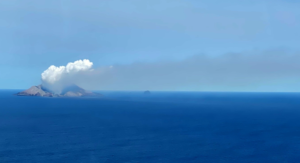
Iceland , Reykjanes Peninsula :
A volcanic eruption remains a possibility at Reykjanes Peninsula ,
Updated 09.03. at 12.30
About 5:20 this morning, the activity at Mt. Fagradalsfjall, south of the corridor, increased with a sudden increase in seismic tremor. However, the unrest soon decreased. Magma movements are a likely cause for this activity which is very localized to the south of the magma intrusion. The tremor is an indication that the intrusion is expanding.

Variable levels of seismic tremor are to be expected during such periods of seismic unrest. Therefore, it is likely that there will be periods of intense tremor interspersed with less intense activity over the coming days. A volcanic eruption remains a possibility. Therefore, scientists and civil protection staff are on alert, and they are ready to respond to a range of situations, including damaging earthquake activity or a volcanic eruption.
Possible development is as follows:
The ongoing seismic activity reduces in the coming days and weeks.
The seismic swarm will increase in intensity, possibly with an earthquake up to magnitude magnitude 6 in the area.
An earthquake up to magnitude 6.5 could be triggered in a nearby volcanic system, roughly 20 km east of the current location of the activity.
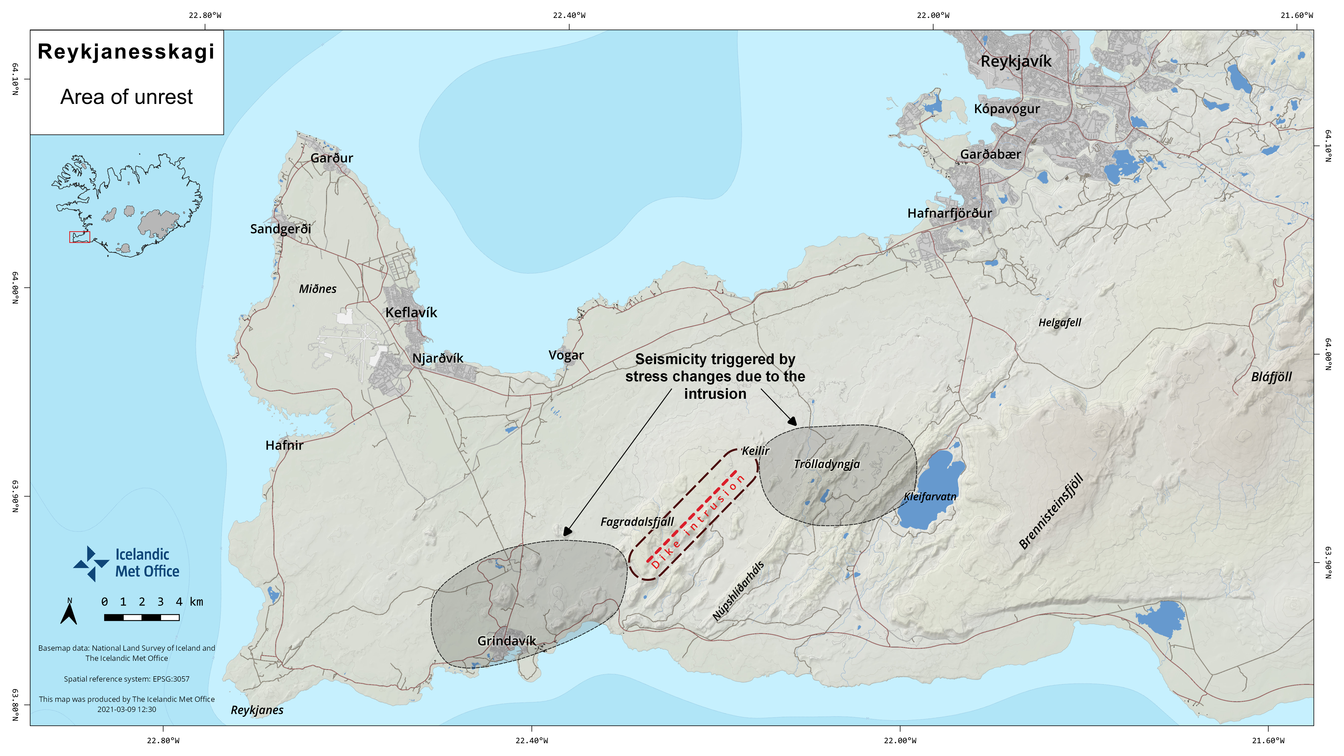
This picture shows the location where the magma chamber is forming under the earth’s crust. When magma flows into the sedimentary strata and forms magma tunnels, as is currently the case in the area of unrest between Keilir and Fagradalsfjall, pressure is formed in the earth’s crust. This creates tension on the east and west sides of the area of unrest.
Magma intrusions continue, resulting in:
An eventual decrease in magma inflow, resulting in the magma solidifying in place without an eruption.
An effusive volcanic eruption could occur, resulting in lava flows that should not threaten inhabited areas of the peninsula.
At 03:14 an earthquake of M5.1 occurred in the SW-part of Fagradalsfjall. It was felt in the SW part of Iceland.
9th of March . At 23:01 a M4.0 occurred in Fagradalsfjall, a few minutes later a M3.7 followed. They were felt in SW Iceland. At 18:45 last night the frequency of minor earthquakes increased but no signs of volcanic tremor was detected. A few earthquakes above M3.0 were detected along this activity, the largest a M3.4 at 20:40. At 5:20AM a tremor pulse was detected in the area and lasted for about an hour.
Source : Vedur is .
Italy / Sicily , Etna :
Weekly bulletin, from March 01, 2021 to March 07/03/2021 (issue date March 09, 2021)
SUMMARY OF THE STATE OF ACTIVITY
In the light of surveillance data, it is highlighted:
1) VOLCANOLOGICAL OBSERVATIONS: Paroxysmal episodes at the Southeast Crater, separated by intervals of relative calm; intracrater explosive activity and degassing of other summit craters
2) SEISMOLOGY: Low seismic activity of fracturing; large and sudden variations in the amplitude of the tremor are correlated with the phases of volcanic activity.
3) INFRASONO: high infrasound activity
4) DEFORMATIONS: The significant deflation of the volcanic building continues, which began on February 16, 2021, with the start of the sequence of lava fountains episodes.
5) GEOCHEMISTRY: SO2 flow at a medium-low level
HCl flow occurs at a medium-low level.
The CO2 flux from the soil remains at the mean degassing values.
The partial pressure of dissolved CO2 does not show significant changes.
No update is available for the C / S report.
The isotopic ratio of helium is at high values.
6) SATELLITE OBSERVATIONS: The thermal activity in the summit area is at a high level.
VOLCANOLOGICAL OBSERVATIONS
Etna’s activity during the week in question was observed through the network of visual and thermal surveillance cameras, and by INGV-OE personnel in the field on various occasions during and after the eruptive events.
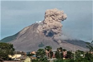
During the week, there were 3 eruptive events, respectively the eighth episode on March 2, the ninth on March 4 and finally the tenth episode on March 7. Details of the individual episodes are described below.
– On March 2, from 10:45 UTC we observe the resumption of a weak Strombolian activity at the Southeast Crater, this activity undergoes an increase from 11:34 UTC with a consequent emission of ash. Due to cloud cover, it was not possible to make continuous observations.
At 12:24 UTC, Strombolian activity at the Southeast Crater suddenly turns into a lava fountain producing an eruptive column that cuts through the cloud cover reaching a height of about 9,000 m above the top of the volcano, dispersing the volcanic cloud over the slopes of the southern part of the volcano causing the fall of ash and lapilli in the towns of Nicolosi, Aci San Antonio, Pedara and finally in Catania. Lava fountain activity at Southeast Crater ceased at 2:50 p.m. UTC.
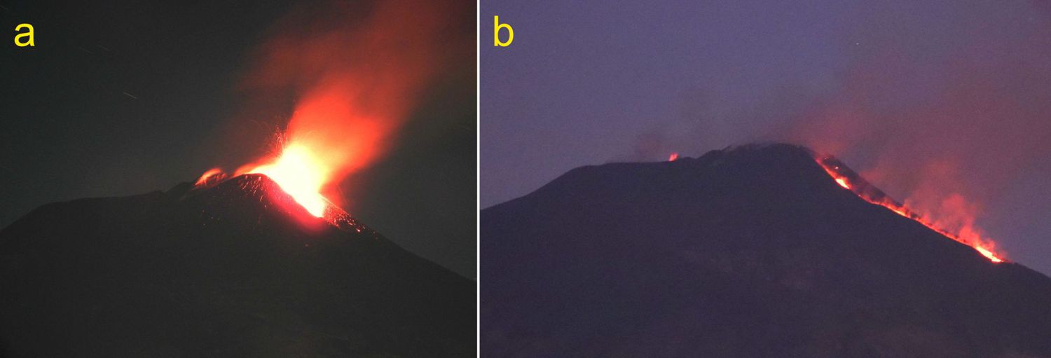
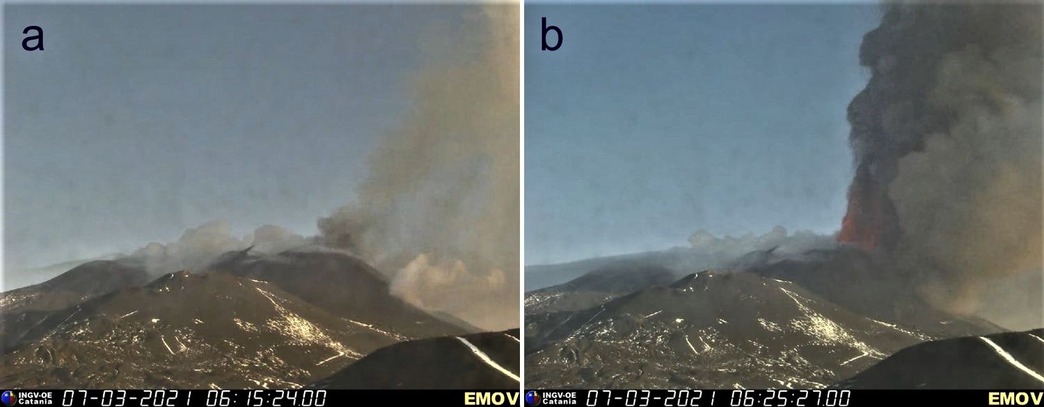
(a) Strombolian activity at the Southeast Crater at 4:15 a.m. on March 4, 2021, seen from Tremestieri Etneo. (b) The Southeast Crater at 5:45 am on March 4, 2021. Strombolian activity stopped, lava overflow with little power; more to the left, we see a small Strombolian explosion at the Voragine crater. Photos are by Boris Behncke, INGV.
-The same phenomenology occurs on March 4 from 00:20 UTC where we observe the resumption of a weak Strombolian activity at the Southeast Crater which increases from 01:00 UTC, producing ash emissions which quickly disperse in the atmosphere in the northeast direction. At the same time, the Voragine crater shows lively Strombolian activity with explosive phenomena protruding from the edge of the crater. Strombolian activity at the Southeast Crater gradually increases around 02:20 UTC to move to the lava fountain stage. At 4:15 am, Strombolian activity at the Southeast Crater is considerably reduced while the lava overflow towards the Valle del Bove remains active, the small flow continues to be fed, from an opening in the eastern sector at the base of the Crater South-East, with a clearly visible projection activity. Explosive activity in the Voragine crater persists with a slight emission of ash and sustained degassing at the Northeast crater. At 7:50 UTC, Strombolian activity resumes again passing through a lava fountain about 300 m high. The phenomenon evolves forming an eruptive column of 11,000 m above the summit of the volcano with dispersion of ash and fallout of lapilli in the villages of Fiumefreddo, Linguaglossa and the region of Reggio Calabria.
(a) Lava fountain about 800 m high like the thermal surveillance camera at Monte Cagliato, east side of Etna. (b) End of the lava fountain and cone of the Southeast Crater covered with hot pyroclastic material. Image of the thermal surveillance camera on Montagnola, the high southern slope of Etna. The times of the images are one hour (UTC) behind the local time.
– The 10th lava fountain episode at Southeast Crater (CSE) began between 00:00 and 01:00 UTC approximately on March 7, 2021, when a small flow was observed from the surveillance cameras of the INGV-OE lava emitted by the effusive vent that opened on March 4, 2021 at the base of the Southeast Crater, and at the same time, the resumption of Strombolian activity at the level of the crater was also observed. At 03:30 UTC, an increase in Strombolian activity was recorded with the formation of an eruptive cloud which reached a height of about 5000 m above sea level. dispersing to the east. As for the lava flow, it extended into the upper part of the Valle del Bove and the front was at about 2900 m above sea level. At approximately 03:50 UTC, the front had reached an altitude of about 2800 m above sea level, and in addition, an overflow of lava was also observed from the upper eastern slope of the Southeast Crater.
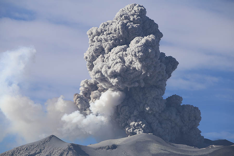
From 04:20 UTC, a further intensification of Strombolian activity was recorded and the lava flow fronts were located at an altitude of about 2700 m above sea level. From around 06:00 UTC, the Strombolian activity at the Southeast Crater had passed to a lava fountain and at 06:20 UTC, it had formed an eruptive column that had well exceeded the height of 10,000 m above sea level. The fountain activity lasted about 1 hour, in fact around 07:10 UTC it had completely ceased, a weak ash emission activity remained at the Southeast Crater. The volcanic cloud dispersed in the eastern sector, producing, as indicated by the staff of INGV-OE, mainly ash and lapilli, falling on the villages of Etna de Milo, Fornazzo, Trepunti, Giarre, Macchia di Giarre, Mascali, Riposto and Torre Archirafi. From 09:50 UTC, the resumption of Strombolian activity at the Southeast Crater is observed: the activity is intense and feeds a cloud of ash which disperses in the eastern sector of the volcano. As of approximately 12:10 UTC, this explosive activity ceased.
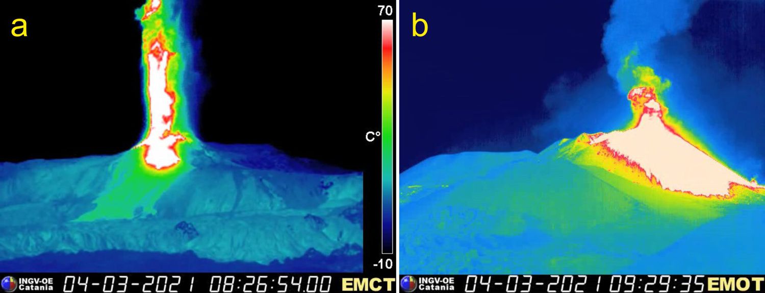
Two images from the visual surveillance camera on the Montagnola, showing how the activity of the Southeast Crater, in 10 minutes, between 07:15 and 07:25 local time on March 7, 2021, went from weak Strombolian explosions (a) to the stage of sustained lava fountains and eruptive column placement (b).
Volcanic tremor:
The evolution of the average amplitude of the volcanic tremor during the week in question was conditioned by the appearance of intense phases of volcanic activity in the Southeast crater. The lava fountains that occurred on March 2, 4 and 7 brought the amplitudes to very high values and developed within a few hours. In the periods between these paroxysmal episodes, the tremor returned to medium-low values. Likewise, the sources of the tremor were found in correspondence with the Southeast crater at depths between 2400 and 3000 m above sea level during the fountains, while in the phases of medium-low tremor, they moved in correspondence of the craters of Bocca Nuova and Voragine at more variable depths.
Press release on ETNA’s activity, 09 March 2021, 19:14 (18:14 UTC).
The National Institute of Geophysics and Volcanology, Osservatorio Etneo, announces that Strombolian activity at the Southeast Crater has resumed. As for the average amplitude of the volcanic tremor from 17:30 GMT, there is an increase, which is currently on the medium-high values. The source of the tremor is located at the Southeast Crater at a depth of about 2500 meters above sea level. The infrasound activity is also increasing and is located in the Southeast Crater. Data from GNSS ground deformation and tilt monitoring networks show no significant changes.
Press release on ETNA’s activity, March 10, 2021, 01:48 (00:48 UTC).
The National Institute of Geophysics and Volcanology, Osservatorio Etneo, announces that after a short return phase, the average amplitude of the volcanic tremor, from 21:30 GMT, began to increase to reach the second level threshold, with a source located in correspondence with the Southeast Crater at about 3000 m above sea level. Infrasound activity is also sustained both in the speed of occurrence and in the energy of events. The location of infrasound events remains with the Southeast Crater. The Strombolian activity of the Southeast Crater has passed to the stage of a lava fountain, the lava flow is fed and reached an altitude of about 2200 meters above sea level. Due to the cloud cover, it is not possible to observe the ongoing activity continuously. The data from the GNSS network do not show significant variations, while the inclinometric network shows modest variations of concomitance with the current activity.
the activity of the lava fountain at the Southeast Crater ended at 03:30 UTC, the lava emission that develops along the western slope of the Valle del Bove continues to be moderately fed as the front of lava reached the altitude of about 1,800 m above sea level.
Source : INGV.
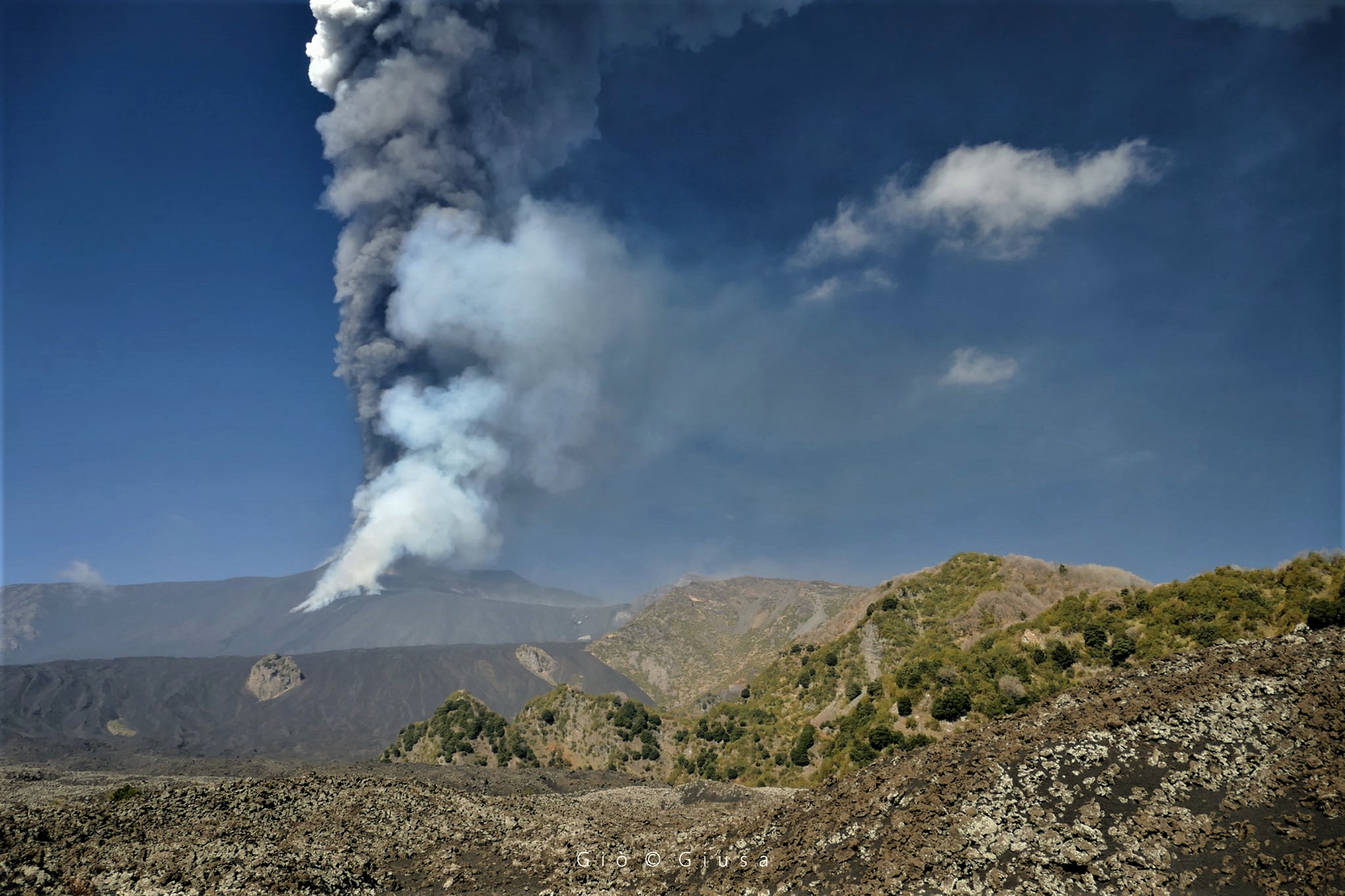
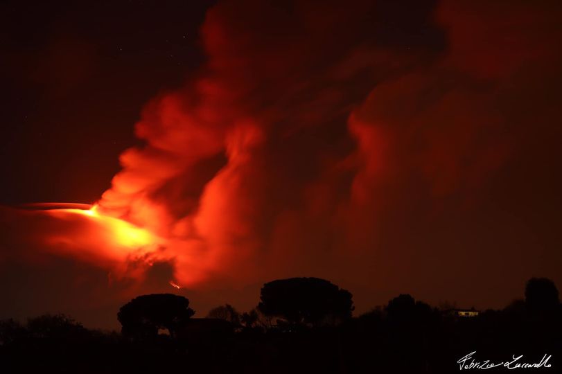
Photos : Gio Giusa , Boris Behncke , INGV , Fabrizio Zuccarello .
Peru , Sabancaya :
Analysis period: from March 01, 2021 to March 07, 2021, Arequipa, March 08, 2021.
Alert level: ORANGE
The Geophysical Institute of Peru (IGP) reports that the eruptive activity of the Sabancaya volcano remains at moderate levels, that is to say with the recording of an average of 85 daily explosions, with columns of ash and gas up to 2 km altitude above the summit of the volcano and their consequent dispersion. Therefore, for the following days, no significant change is expected in eruptive activity.

The IGP recorded and analyzed the occurrence of 1867 earthquakes of volcanic origin, associated with the circulation of magmatic fluids inside the Sabancaya volcano. An average of 85 explosions were recorded daily, which corresponds to an increase of 54% compared to January 2021. During this period, Volcano-Tectonic (VT) earthquakes associated with rock fracturing were located mainly in the South-East and North-East of Sabancaya and presented magnitudes between M2.1 and M2.6
The monitoring of the deformation of the volcanic structure using GNSS techniques (processed with fast orbits) does not present any significant anomalies. However, in general, an inflation process was observed in the northern sector (around the Hualca Hualca volcano). Visual surveillance made it possible to identify columns of gas and ash up to 2 km altitude above the summit of the volcano, which were scattered towards the southwest, south, west and northwest sectors of Sabancaya.
RECOMMENDATIONS
• Keep the volcanic alert level in orange.
• Do not approach within a radius of less than 12 km from the crater.
Source : IGP.
Photo : Photovolcanica , http://www.photovolcanica.com/VolcanoInfo/Sabancaya/Sabancaya2016_00249.JPG
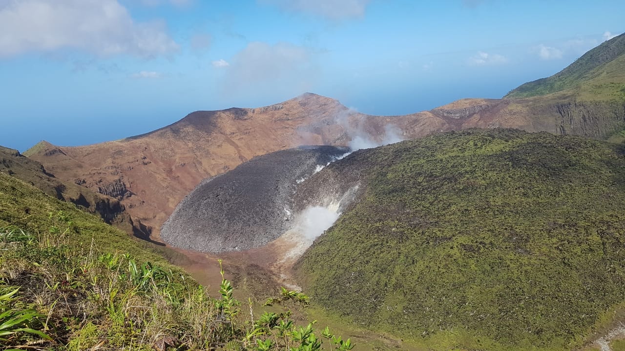
Saint Vincent , Soufrière Saint Vincent :
VOLCAN LA SOUFRIÈRE ACTIVITY BULLETIN, 08 MARCH 2021, 8:00 p.m.
-The monitoring team made a visit to the La Soufrière Volcano last week for visual observations and drone survey of the dome. Another visit was made to the hot springs on the Wallibou River for water sampling, gas and temperature measurements. Measurements were also undertaken of carbon dioxide in the soil along the Wallibou riverbed.
-Clear weather conditions at the top of the volcano allowed for aerial photographs to be taken but no new volumes were obtained due to technical problems with the images. Visual observations of the inside of the volcano during the visit confirmed that slow dome growth continues with the south-eastern front of the dome now in line with the pre-existing fumarole on the 1979 dome.
No new data is available on the gas coming from the volcano.
The ongoing outflow of magma onto the crater floor continues with periodic changes in the rate of dome growth.
The gas coming from the dome continues to cause damage to vegetation in the hill side areas on the south-western side of the volcano. These gases have become more acidic and have the capacity to cause respiratory harm to human beings which can result in unconsciousness and even asphyxiation. There can also be a corrosive effect on the skin and eyes, even with short exposure. It is imperative therefore, to avoid site seeing at the La Soufriere Volcano.
The National Emergency Management Organisation is reminding the public that no evacuation order or notice has been issued.
NEMO continues to appeal to the public to desist from visiting the La Soufrière Volcano, especially going into the crater, since doing so is extremely dangerous.
Source : UWI.
Photo : Nemo .
Ecuador , Sangay :
Information, VOLCÁN SANGAY Nº 2021-034, Quito, Tuesday March 9, 2021.
Yesterday, March 9, 2021, at 5.30 p.m. (TL), satellite images continue to observe the emission of ash from the Sangay volcano, whose cloud is directed towards the North-North-West and which could generate light ash falls in the province of Chimborazo (possibly the canton of Riobamba and Licto), it is recommended to take the necessary precautions.
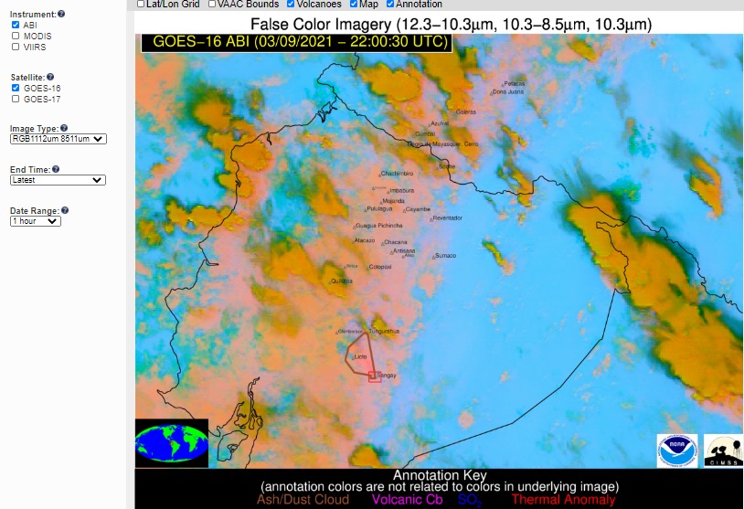
GOES-1 satellite image
The SAGA seismic station has been recording a high frequency signal since 10:25 a.m. (TL), possibly associated with the appearance of mudslides and debris (lahars) which descend through the ravines of the Sangay volcano following the presence of rains in the area. This phenomenon is recurrent in the current eruptive period since the rains on the volcano remobilize the material accumulated on the flanks. Proximity to rivers and their tributaries is not recommended.
Source : IGEPN.
