March 04 , 2021 .
Italy , Stromboli :
Weekly bulletin from February 22, 2021 to February 28, 2021 (issue date March 02, 2021)
SUMMARY OF THE STATE OF ACTIVITY
In the light of surveillance data, it is highlighted:
1) VOLCANOLOGICAL OBSERVATIONS: Normal explosive volcanic activity of strombolian type. The total frequency of events showed values between medium-low levels (8 events / h) and medium levels (12 events / h). The intensity of the explosions was mainly medium-low in the North crater area and medium in the Center-South area.
2) SEISMOLOGY: The monitored seismological parameters do not show significant variations.
3) DEFORMATIONS: The island’s soil deformation monitoring networks did not show any significant changes during the period under review.
4) GEOCHEMISTRY: The flow of SO2 is at a medium-low level
C / S ratio: the values are at high levels (C / S = 15.51 measurements of 02/28/2021).
Helium isotope ratio: there are no new updates; the old values relating to the sampling of 5/02/2021 were at high values (R / Ra = 4.42).
5) SATELLITE OBSERVATIONS: The thermal activity in the summit area is at a low level.
VOLCANOLOGICAL OBSERVATIONS
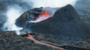
In the period under observation, the eruptive activity of Stromboli was characterized by the analysis of the images recorded by the surveillance cameras INGV-OE located at 190 m, Punta Corvi and 400 m.
NORTH ZONE
There were two active vents at crater N1 which produced explosions of coarse material (bombs and lapilli) which reached about 100-120m above the vents. At crater N2, 4 mouths were visible, including 3 aligned approximately North-South and a hornito placed near the limit with crater N1. Of these 4 mouths, only 2 were active. The explosions were quite small, containing very little exclusively coarse material. The hornito was limited simply to passive degassing.
It should also be noted the presence of a large deposit of sulfur on the hornito and on the south vent as evidence of the very modest amount of erupting material.
CENTER-SOUTH ZONE
There were three vents (CS1), two of which were very small (one inactive and one barely degassing) and one larger vent characterized by emissions and projection activity (with continuous emissions of matter on 02/24, intermittent on 02/25). In place of the hornito on the Sciara (CS3) side, there was a large, deep crater with a small hornito on the bottom that made pressurized gas explosions only. In the SW sector (CS2), there were at least 4 active vents: a hornito which produced explosions with very little erupting coarse matter; two vents behind the hornito (towards the Sciara) which emitted reshaped ashes and which in the strongest explosions were activated simultaneously; further north (limit with CS1-CS3) there was a large, deep crater with an invisible vent on the bottom that only made small gas explosions.
In conclusion, the activity was quite low and the amount of erupting material was very low.
Observations picked up by surveillance cameras.
NORTH ZONE
The N1 crater, with two emission points, produced explosions of low intensity (less than 80 m high) to medium-high intensity (sometimes the projectiles reached 250 m high) emitting coarse materials (lapilli and bombs) mixed with fine materials (ash). The N2 crater, with four emission points, showed mainly low intensity explosive activity emitting coarse matter. The average frequency of explosions varied from 5 to 9 events / h.
CENTER-SOUTH ZONE
The explosions observed produced emissions of ash mixed with coarse materials, with an average and sometimes high intensity (the products exceeded 250 m in height). The explosive activity showed average hourly frequency values ranging from 2 to 6 events / h.
Source : INGV.
Photos : Stromboli Adventures , Webcam .
Iceland , Reykjanes Peninsula :
A tremor pulse was detected at 2:20 p.m. and is being measured in most of Iceland’s seismic stations. The impulse is located south of Keilir by Litli Hrútur. Similar signals have been observed leading to rashes, but no eruption has been confirmed. IMO is working on a more in-depth analysis of the momentum.
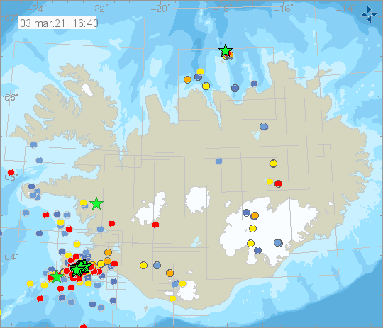
An earthquake M4.0 at 15:11 was measured in the same area as the tremor pulse, and many smaller earthquakes have been measured there today. Earlier today a few earthquakes around M4 were detected in the area. An intense earthquake swarm started on the Reykjanes Peninsula on February 24th with an earthquake M5.7 followed by an M5.0.
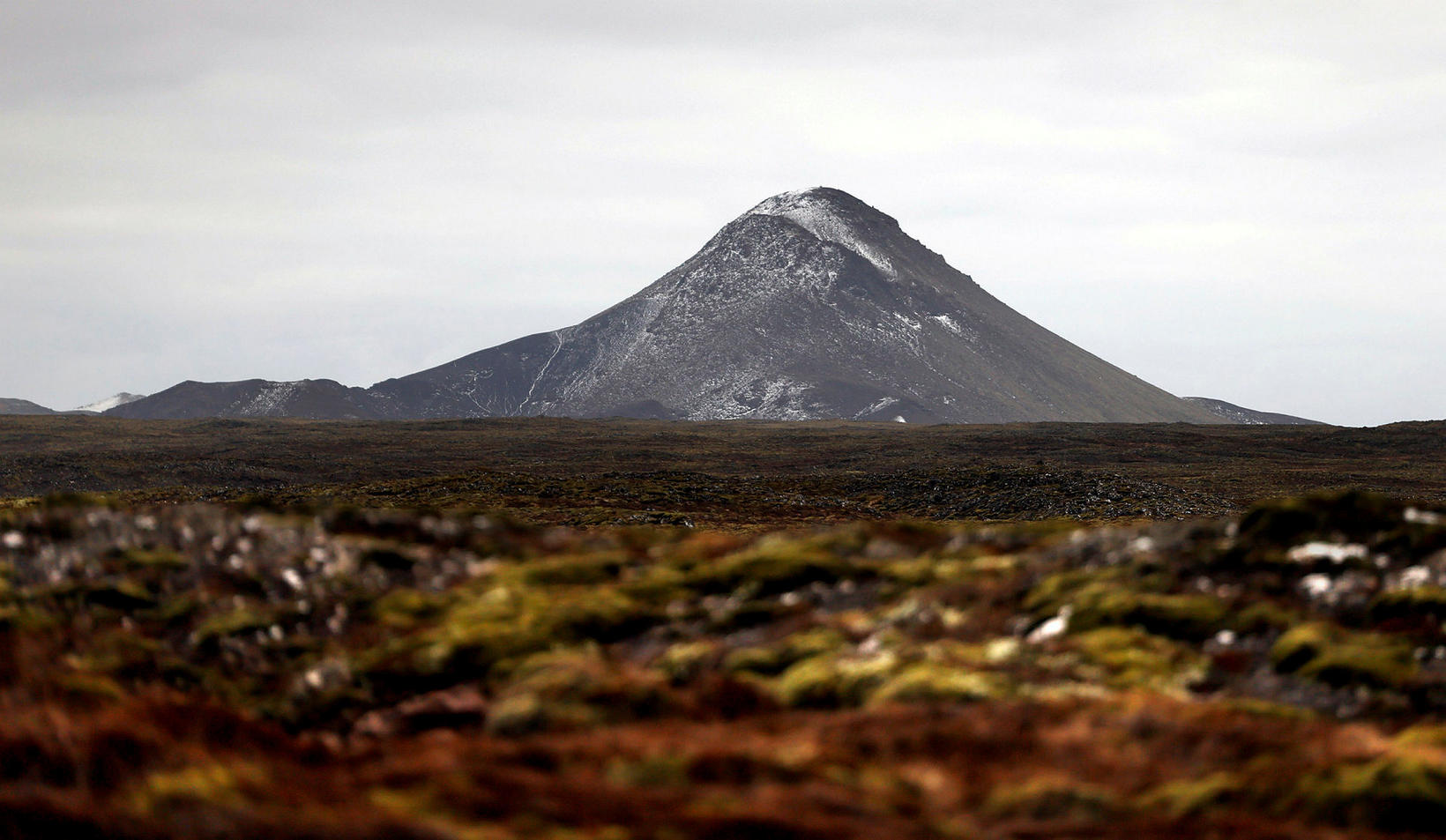
Keilir mountain. Photo/Eggert Jóhannesson
Since then, many earthquakes over M4.0 have been detected and two earthquakes over M5.0. They occurred on February 27th and March 1st. Around 17.000 earthquakes have been detected in the area since the activity started.
Today (March 4th) at 00:59 an M4.1 earthquake was detected 1.4 km SE of Fagradalsfjall. Most of the activity since mid-night has been near Fagradalsfjall and have been drifting a bit SW, compared to yesterday. The tremor and earthquake activity decreased a bit during the night, but increased again around 05. 15-20 earthquakes over M3.0 have been detected since mid-night.
The signals possibly indicated magma rising towards the surface and prompted IMO to raise the Aviation Color Code for Krýsuvík to Orange.
Source : Vedur is.
Photo : Keilir mountain /Eggert Jóhannesson.
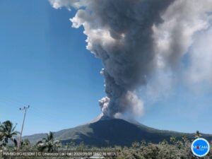
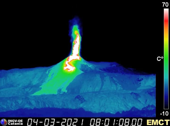
Italy / Sicily , Etna :
Press release on ETNA activity, 04 March 2021, 01:42 (00:42 UTC).
The National Institute of Geophysics and Volcanology, Osservatorio Etneo, reports that from 00:20 UTC a resumption of weak Strombolian activity is observed at the Southeast Crater. A slight increase in the average amplitude of the volcanic tremor is observed. Infrasound activity also shows an increase in the number of events. The locations of the tremors indicate a displacement of the source towards the Southeast Crater.
Press release on ETNA activity, 04 March 2021, 02:16 (01:16 UTC).
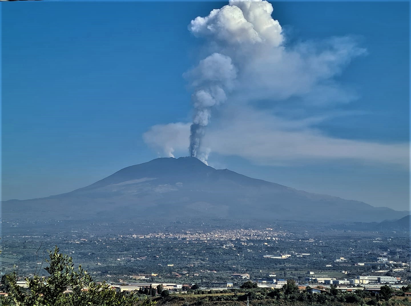
The National Institute of Geophysics and Volcanology, Osservatorio Etneo, announces that from 01:00 UTC there is an increase in Strombolian activity at the Southeast Crater, accompanied by the emission of ash which rapidly disperses in the atmosphere towards the North-East. At the same time, the Voragine crater also shows lively Strombolian activity with episodic explosions that rise above the level of the crater rim.
The average amplitude of the volcanic tremor showed a further increase, reaching high values; the sources of the tremor are located in the Southeast Crater.
At the same time, the rate of occurrence of infrasonic events is also increasing, which are also localized to the Southeast Crater.
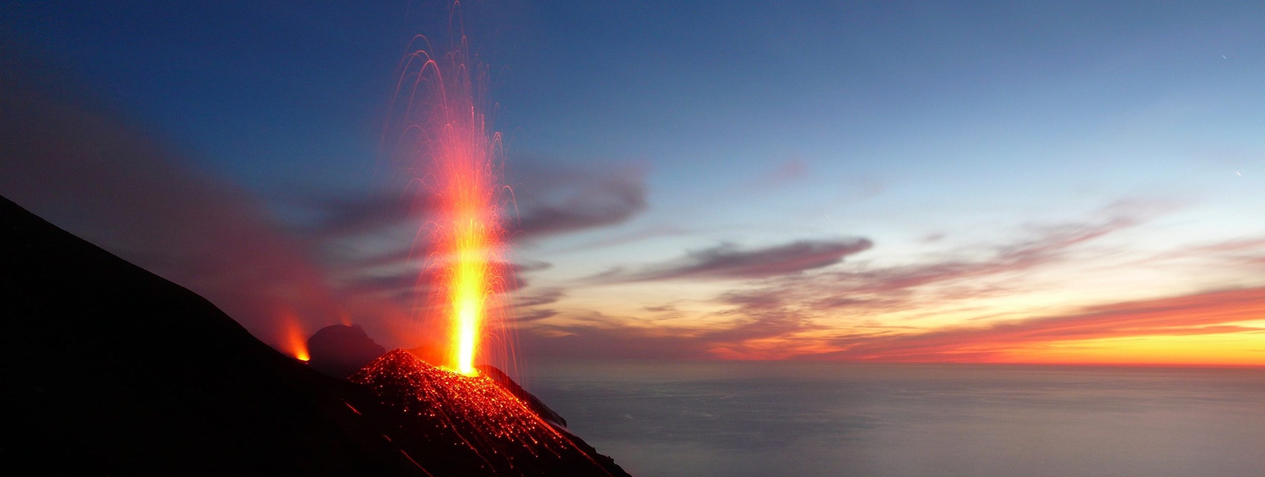
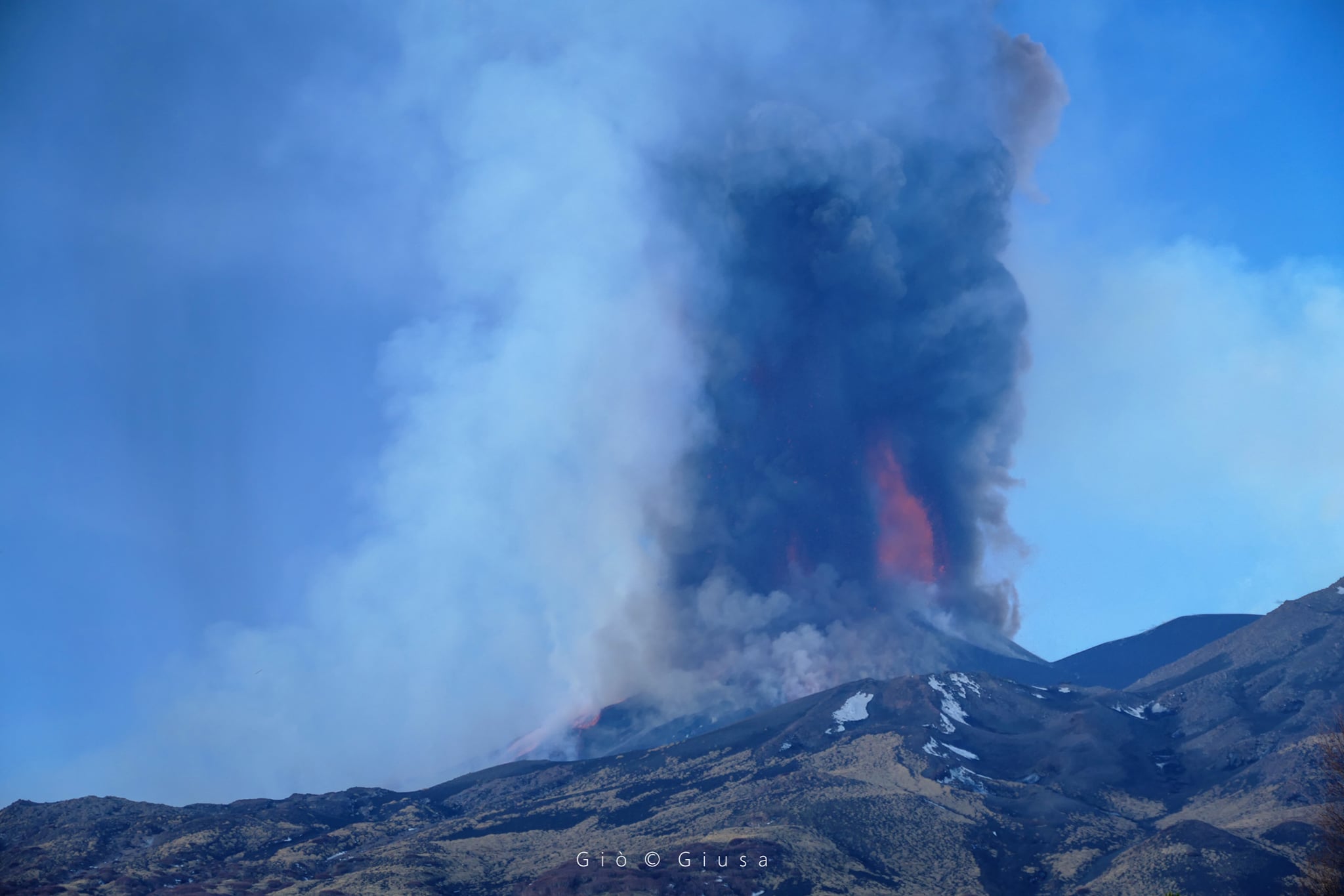
Strombolian activity at the Southeast Crater gradually increased and at around 02:20 UTC it transitioned to the lava fountain stage. At the same time, there is a further gradual increase in the amplitude of the volcanic tremor, the source of which is located in correspondence with the Southeast Crater at nearly 3000 m. From the surveillance cameras, from 03:05 UTC, an overflow of lava can be observed from the Southeast Crater towards Valle del Bove.
Press release on ETNA activity, 04 March 2021, 05:27 (04:27 UTC).
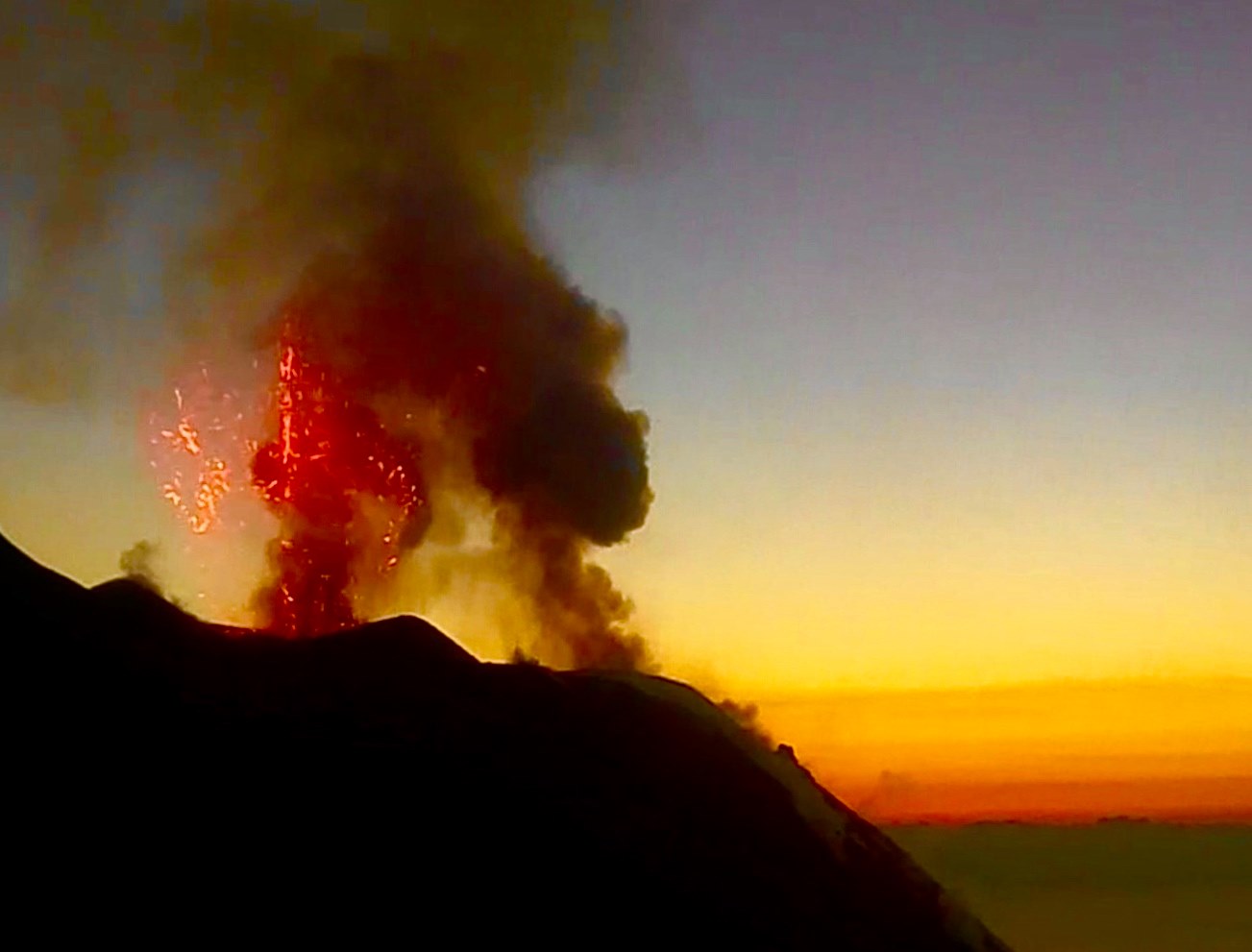
The National Institute of Geophysics and Volcanology, Osservatorio Etneo, reports that from 02:50 UTC there is a decrease in the amplitude of the tremor which is at an average level; from 3:15 a.m. there is also a reduction in infrasonic activity, both in the frequency of occurrence and in the amplitude of the signals. The locations of the sources of infrasonic signals remain in the Southeast Crater. At 4:15 am, Strombolian activity at the Southeast Crater has also significantly reduced while the lava overflow towards the Valle del Bove remains active.
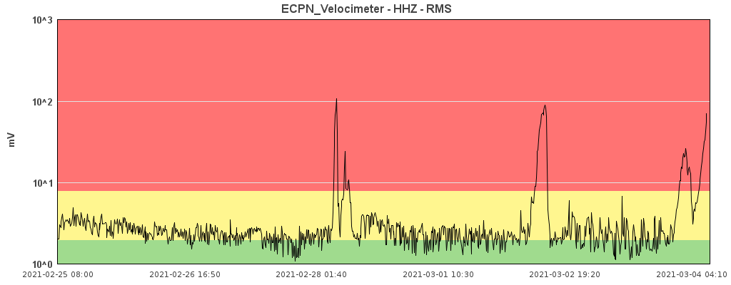
Press release on ETNA activity, 04 March 2021, 08:37 (07:37 UTC).
The National Institute of Geophysics and Volcanology, Osservatorio Etneo, reports that Strombolian activity at the Southeast Crater gradually increased from 07:25 UTC.
At the same time, there is a projection activity at the mouth located at the base of the Southeast Crater, which continues to feed a flow that empties into the Bove valley. The explosive activity of Voragine persists with a slight emission of ash as well as sustained degassing at the Northeast Crater.
At the same time, there is a further gradual increase in the amplitude of the volcanic tremor, the source of which is located in correspondence with the Southeast Crater at nearly 3000 m. The infrasonic activity is also maintained both in the frequency of occurrence and in the amplitude of the signals. The location of infrasound events remains with the Southeast Crater.
At 7:50 UTC, Strombolian activity had shifted to the lava fountain stage. The height of the lava fountain is about 300 m.
Further updates will be communicated shortly.
Source : INGV .
Photos : Gio Giusa , Carmen Plate , ingv .
Guatemala , Pacaya :
SPECIAL VOLCANOLOGICAL BULLETIN, March 3, 2021, 6:45 a.m. local time
STRONG STROMBOLIAN ACTIVITY
As indicated in previous special bulletins, the Pacaya volcano exhibited a high internal dynamic, during the last hours another increasing impulse was recorded which was reflected superficially in a strong Strombolian activity which expels ballistic projections at a height of up to 500 meters above the crater continuously and also sporadically, due to these Strombolian explosions.
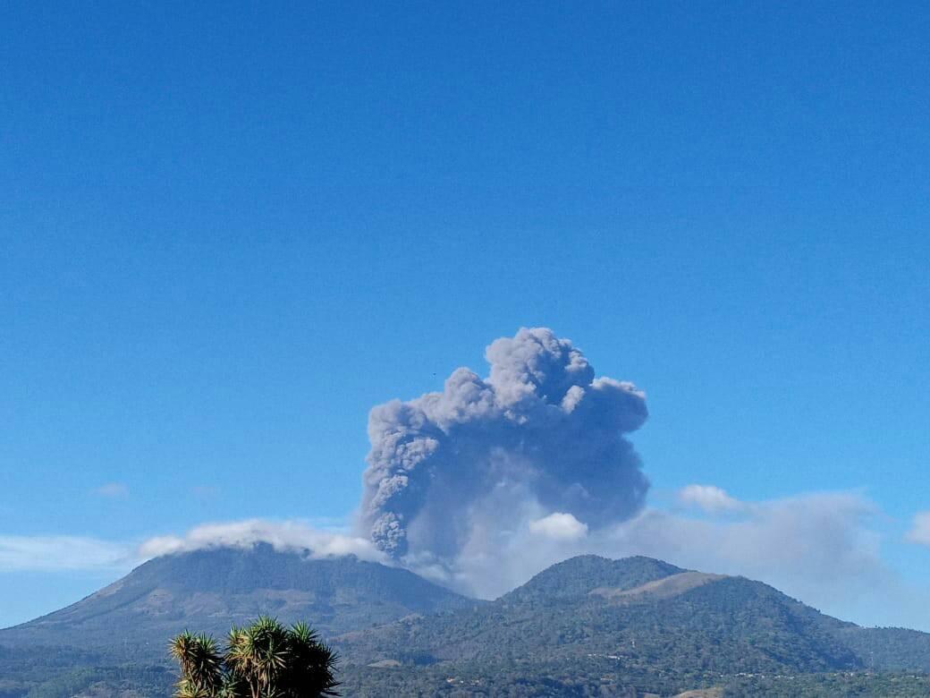
Two new lava flows are reported, so three lava flows in total, one in a South-South-West direction, another in a South direction and another in a South-East direction with lengths between 800 and 1000 meters , presenting several branches in each stream. Columns of ash and gas reaching a height of 3,500 meters above sea level (11,483 feet) move west. Tephra falls are reported in the villages of El Patrocinio and El Rodeo, with probabilities of ash falls in communities such as Los Ríos, Los Jazmines El Rodeo, San José, finca Buenos Aires, the village of Pacaya , the Rio Frio finca and others nearby, heading west, southwest and south of the volcano.
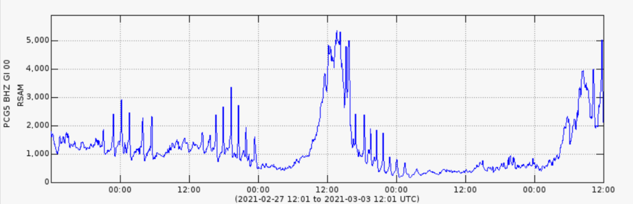
Fig. No. 1: The RSAM (mean seismic amplitude of the PCG5 station) is observed
It is not excluded that the volcanic activity increases and produces an eruption, or that it continues with this tendency to maintain high pulses of increase during the next hours, maintaining the explosions with falling ballistic projections and the emission of columns of ash and gas, such as increasing length or the appearance of new lava flows on the flanks around the volcanic cone.
Source : Insivumeh .
Photo : Darien Paredes
Philippines , Pinatubo :
PINATUBO VOLCANO BULLETIN: 04 March 2021 7:00 AM
This serves as notice for the raising the alert status of Pinatubo Volcano from Alert Level 0 (Normal) to Alert Level 1 (Low-level Unrest).
Since 20 January 2021, the Pinatubo Volcano Network (PVN) has detected a total of 1,722 imperceptible earthquakes beneath the Pinatubo edifice. The first cluster of earthquakes on 20-26 January 2021 occurred along the Sacobia Lineament at depths of 15-28 kilometers and ranged between ML1.0 and ML2.5 in magnitudes. This has been succeeded by a more persistent cluster of earthquakes occurring along a north-northwest-south-southeast-trending structure 10 to 35 kilometers beneath the center of the edifice itself, with a few shallower earthquakes occurring on both ends of the cluster.
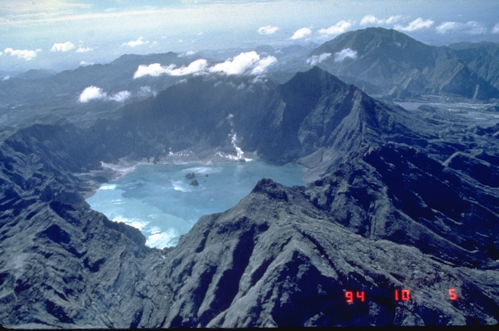
The earthquakes ranged between ML0.5 and ML2.8 in magnitude; all earthquakes recorded are associated with rock-fracturing processes. Measurements at Pinatubo Crater lake in February 2021 yielded a total CO2 flux of 378 tonnes/day which is still within the background range of 1,000 tonnes/day recorded in the past decade. Slight increases in the temperatures of monitored fumaroles or gas vents were recorded but other characteristics such as acidity (pH) remain unchanged.
Source : Phivolcs .
Photo : GVP , Ray Punungbayan, 1994 (Philippine Institute of Volcanology and Seismology).