January 17 , 2021.
Hawaii , Kilauea :
19°25’16 » N 155°17’13 » W,
Summit Elevation 4091 ft (1247 m)
Current Volcano Alert Level: WATCH
Current Aviation Color Code: ORANGE
Activity Summary:
Lava activity is confined to Halemaʻumaʻu with lava erupting from a vent on the northwest side of the crater. This morning, January 15, the lava lake is about 199 m (653 ft) deep and remains stagnant over its eastern half. SO2 emission rates remain elevated.
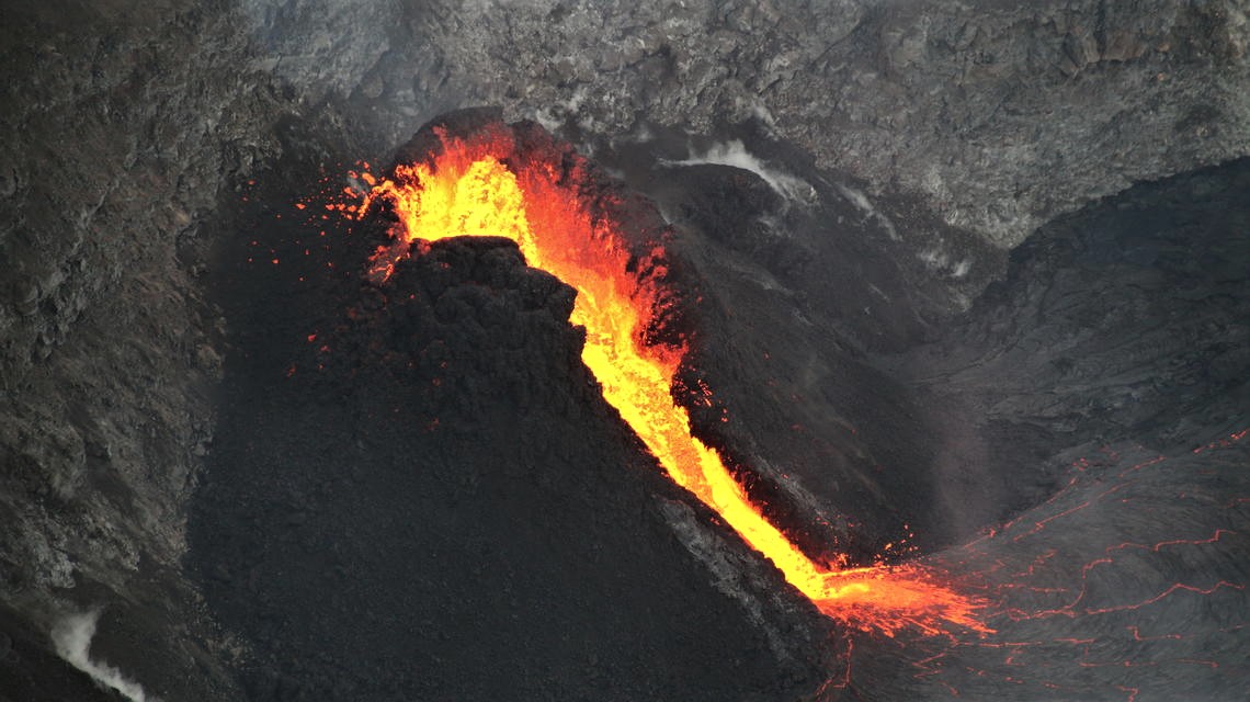
This telephoto image shows the west vent of the ongoing Halema‘uma‘u eruption at about 7:15 a.m. HST on January 14, 2021. Low lava fountaining from the vent cascades into the lava lake below. This morning, January 15, the active west side of the lava lake was approximately 199 m (653 ft) deep, while the western half remains stagnant and several meters (yards) lower
Summit Observations:
The most recent sulfur dioxide emission rate measurements were 2,500 t/d on Monday (Jan. 11)–below the range of emission rates from the pre-2018 lava lake (3,000–6,500 t/d). The predominantly inflationary tilt, that has been recorded at the summit over the past few days, has leveled off in the last 12 hours and is not recording any significant changes. Seismicity remains elevated but stable, with steady elevated tremor and a few minor earthquakes.
Halemaʻumaʻu lava lake Observations:
Low fountaining from the west vent supplies a channel of lava which is pouring into the lava lake within Halema‘uma‘u crater.
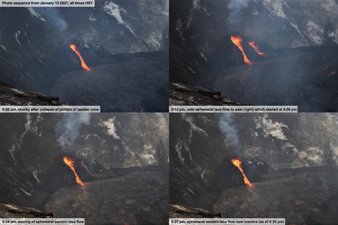
This sequence of four photos was taken from the south rim of Halema’uma’u looking to the northwest. It shows the brief (less than 20 minutes) changes in near-vent activity when a portion of the western vent spatter cone collapsed on January 13, 2021. The first photo was taken seconds after the collapse at 5:06 p.m., showing the main lava spillway. Three minutes later, at 5:09 p.m., a second vent to the east (right) sent a new lava stream down the side of the spatter cone. This ephemeral (short-lived) stream remained active until 5:25 p.m., with the waning stages shown in the bottom photos.
Two hours before this short-term change, HVO scientists had observed a small glowing hole at the source point of the ephemeral lava flow. Occasionally, a small amount of spatter would be ejected from this area, although no spatter was observed from there in the hour before this ephemeral lava flow began.
The three photos at 5:13 p.m., 5:25 p.m., and 5:27 p.m. show that lava from the brief flow created a small delta on the solidified rim of the lava lake.
The active western half of the lava lake was about 199 m (653 ft) deep this morning (Jan. 15) while the stagnant eastern half of the lake remains several meters (yards) lower. The whole lava lake—including the stagnant eastern half—is perched at least 1–2 m (yards) above the crust between the perched lake and the crater wall.
All of the islands have been stationary over the past week as if frozen in the eastern stagnant portions of the lava lake. The dimensions of the main island remained unchanged with its edges several meters (yards) above the lake surface. On January 12, the west end of the island was measured as 8 m (26 ft) above the lava lake surface, with the highest point at 23 m (75 ft) above the surface.
Source : HVO
Photo : USGS / K. Lynn. USGS / N. Deligne
Indonesia , Semeru :
VOLCANO OBSERVATORY NOTICE FOR AVIATION – VONA.
Issued : January 16 , 2021
Volcano : Semeru (263300)
Current Aviation Colour Code : ORANGE
Previous Aviation Colour Code : unassigned
Source : Semeru Volcano Observatory
Notice Number : 2021SMR01
Volcano Location : S 08 deg 06 min 29 sec E 112 deg 55 min 12 sec
Area : East java, Indonesia
Summit Elevation : 11763 FT (3676 M)
.
Volcanic Activity Summary :
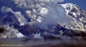
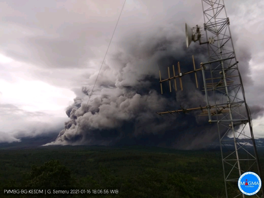
Eruption with volcanic ash cloud at 10h24 UTC (17h24 local)
Volcanic Cloud Height :
Best estimate of ash-cloud top is around 18163 FT (5676 M) above sea level, may be higher than what can be observed clearly. Source of height data: ground observer.
Other Volcanic Cloud Information :
ash-cloud moving to northeast.
Surveillance data:
1. Visual: From January 1 to 15, 2021, the volcano was clearly visible until it was covered in fog. The eruption is still in progress, but generally the eruption column is not observed because it is covered by fog. The crater emits white smoke with low to medium intensity about 200 meters above the summit. The weather is sunny to rainy, with light to moderate winds in the North, North-East, East, South and South-West. The air temperature is around 21 to 31 ° C.
On January 1, 2021 at 2:58 p.m. WIB there was a hot avalanche cloud with a sliding distance and direction that could not be observed because the mountain was covered with fog During the period January 1 to 15 2020, incandescent lava avalanche activity was observed with sliding distances of 500-1000 meters towards Besuk Kobokan. The column of smoke from the eruptions was observed at an altitude of 200-300 m, the color of the thick smoke was white, facing north.
On January 16, 2021 at 5:24 p.m. WIB, a hot avalanche cloud again occurred with a sliding distance of 4 km towards Besuk Kobokan. Lava avalanche activity also occurs with a sliding distance of between 500 and 1000m from Jongring Seloko crater to Besuk Kobokan.
2. Seismicity: The number and types of earthquakes recorded for the period January 1 to January 15, 2021 were dominated by avalanche earthquakes, eruption earthquakes, emission earthquakes. and harmonic tremors. Low numbers of volcanic earthquakes (deep volcanic and shallow volcanic earthquakes) have been recorded. During the observation period, 1 (one) warm avalanche cloud earthquake was recorded, while 14 lahar signals were recorded. On January 16, 2021 at 5:24 p.m. WIB, an earthquake was recorded with a hot cloud with a maximum amplitude of 22 mm and a duration of 4287 seconds.
Analysis:
After the hot cloud avalanches of December 1, 2020, the volcano visually shows the high incidence of incandescent lava avalanches with a sliding distance ranging from 500 to 1000 meters in the direction of Besuk Kobokan. Meanwhile, hot avalanche clouds were still observed.
Seismicity is always fluctuating, dominated by surface earthquakes. The number of occurrences of avalanche earthquakes, eruption earthquakes, emission earthquakes and harmonic tremors during this period is always high, indicating that the movement of magma towards the surface always happens.
The number of flood signals started to increase, indicating that the incidence of ash in the Besuk Kobokan River has started to increase along with the increase in precipitation in this region.
Source : Magma Indonésie , PVMBG.
Photos : PVMBG , tjindrakusuma via Sherine France.
Costa Rica , Turrialba / Poas :
Daily report of the state of volcanoes. Date: 01/15/2021
Updated at: 11:25:00.
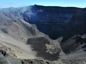
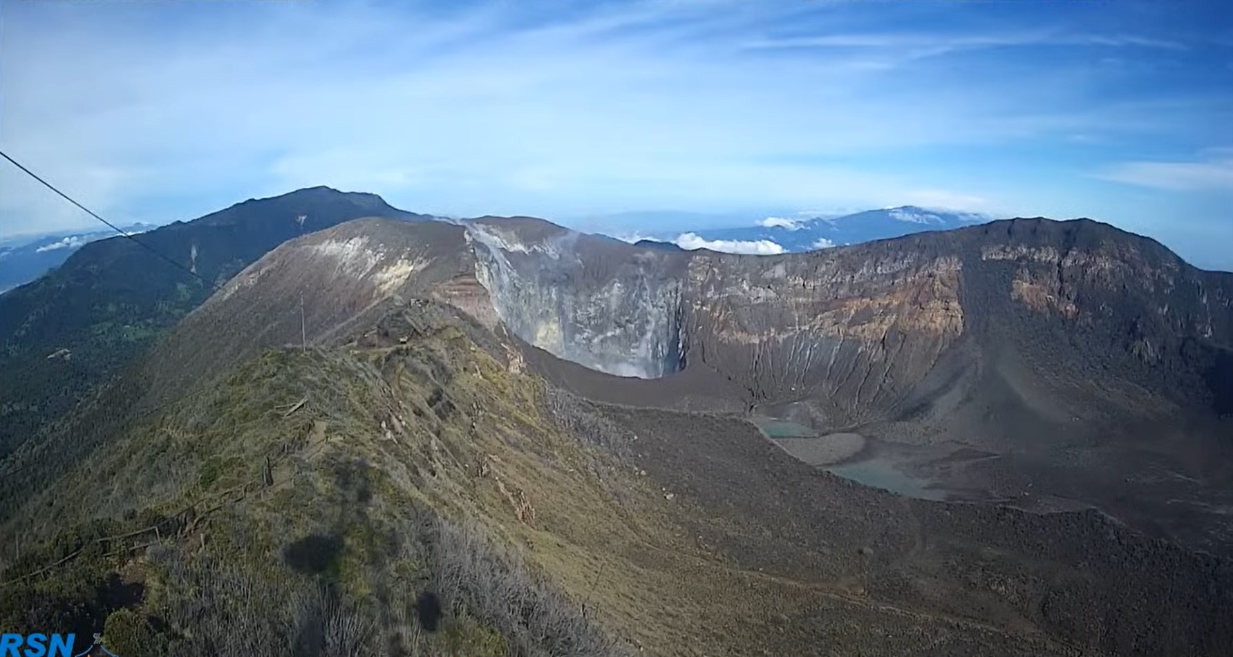
Turrialba volcano
No eruption is reported.
Seismic activity is similar compared to yesterday.
At the time of this report, the winds are blowing to the southwest.
Seismographs continue to record frequent low-amplitude, short-lived LP-type volcanic earthquakes associated with fumarolic degassing. The MultiGAS system which continuously monitors the composition of the volcanic gases emitted by the Turrialba records sulfur dioxide, SO2, in the range between 4 and 5 ppm and lower amounts of hydrogen sulfide, H2S (H2S / SO2 = 0, 3). This means that the quantities of magmatic gases emitted into the atmosphere are very low and consistent with the general decrease in Turrialba activity observed between 2019 and today.
Poas volcano
No eruption is reported.
Seismic activity is similar compared to yesterday.
At the time of this report, the winds are blowing south.
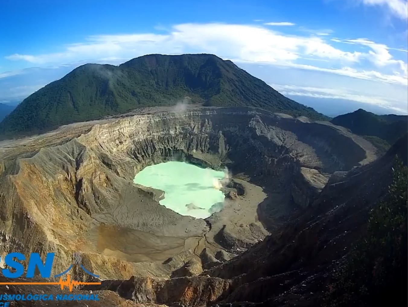
The Poás seismographs continue to record several dozen low-amplitude LP-type earthquakes of short duration in the last 24 hours associated with fumarolic degassing in the active crater. The hyper-acidic lake shows a moderate rise in water level. Its color remains green.
Source : Ovsicori.
Photos : RSN
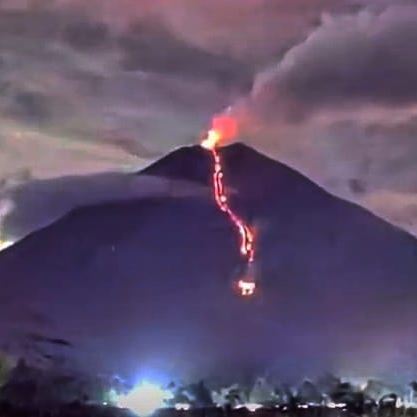
Mexico , Popocatepetl :
January 16, 11:00 a.m. (January 16, 5:00 p.m. GMT)
During the last 24 hours, according to the monitoring systems of the Popocatepetl volcano, 25 exhalations and 873 minutes of tremor have been identified, accompanied by emissions of water vapor, volcanic gases and small amounts of ash. In addition, yesterday, two volcano-tectonic earthquakes were recorded at 12:24 and 15:49, both with a calculated magnitude of M1.4.
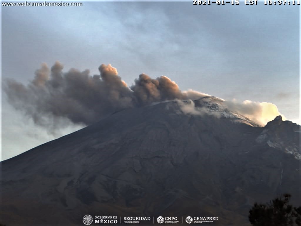
Derived from the recent volcanic activity, yesterday at 8:15 p.m., a slight fall of ash was reported in the municipality of San Nicolás de los Ranchos, Puebla.
At the time of this report, there was partial visibility, a slight emission of water vapor and gas was observed which dispersed towards the northeast.
CENAPRED urges not to go as close as possible to the volcano and in particular to the crater, because of the danger posed by the fall of ballistic fragments and, in the event of heavy rains, to stay away from the bottom of the ravines due to the danger of mudslides.
The Popocatépetl volcanic alert semaphore is in YELLOW PHASE 2.
Source : Cenapred .