January 03 , 2021 .
Hawaii , Kilauea :
19°25’16 » N 155°17’13 » W,
Summit Elevation 4091 ft (1247 m)
Current Volcano Alert Level: WATCH
Current Aviation Color Code: ORANGE
Activity Summary:
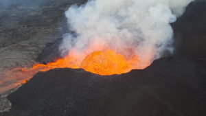
Lava activity is confined to Halemaʻumaʻu with lava erupting from vents on the northwest side of the crater. Early this morning (Jan. 2), the lava lake was 189 m (620 ft) deep with a narrow black ledge around it. SO2 emission rates were still elevated.
The Kīlauea summit eruption continues from the west vent within Halema‘uma‘u crater with no significant changes in the past few days. Early this morning (January 2) at approximately 1:30 a.m. the lava lake was measured at about 189 m (620 ft) deep. HVO scientists monitor the eruption from within an area of Hawai‘i Volcanoes National Park that remains closed to the public for safety reasons.
Summit Observations:
Sulfur dioxide emission rate measurements made Thursday (Dec. 31) were about 6300 t/d and in the range 3,000-6,500 t/d since Sunday (Dec. 27)–the same range of values that was common for the pre-2018 lava lake. Summit tiltmeters recorded weak deflationary tilt over the past day. Seismicity remained elevated but stable, with steady elevated tremor and a few minor earthquakes.
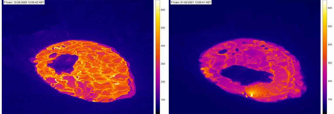
There have been no major changes in the Kīlauea summit eruption over the past week. These two thermal webcam images compare the Halema‘uma‘u crater on December 26, 2020 at 12:00 p.m. HST (left) and January 2, 2021 at 12:00 p.m. HST (right). Around 3:00 a.m. HST on December 26 the dominant northern fissure vent was drowned by the lava lake and shut down. In the week since then the west vent has continued to erupt and supply lava to the lake. Occasional weak spatter has slowly built a cone at the vent, visible in the lower center of the right image. The main island in the lava lake has migrated west (bottom of frames) and rotated over the past week. Additional summit webcam images can be found here. USGS F1cam thermal webcam images.
East Rift Zone Observations:
Geodetic monitors indicate that the upper portion of the East Rift Zone (between the summit and Puʻu ʻŌʻō) contracted while the summit deflated. There is no seismic or deformation data to indicate that magma is moving into either of Kīlauea’s rift zones.
Halemaʻumaʻu lava lake Observations:
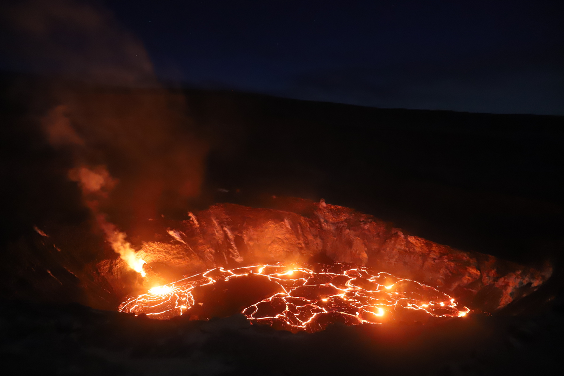
The west vents spattered while erupting lava flowed through crusted-over channels into a lava lake within Halemaʻumaʻu crater.
The lava lake was 189 m (620 ft) deep early this morning (Jan. 2). The most recent thermal map (Dec. 30) provided the lake dimensions as 800 by 530 m (875 by 580 yds) for a total area of 33 ha (82 acres). The narrow (10-30 m or 11-33 yd) ledge around the lake was about 1-2 m (1-2 yds) above the active lake surface .
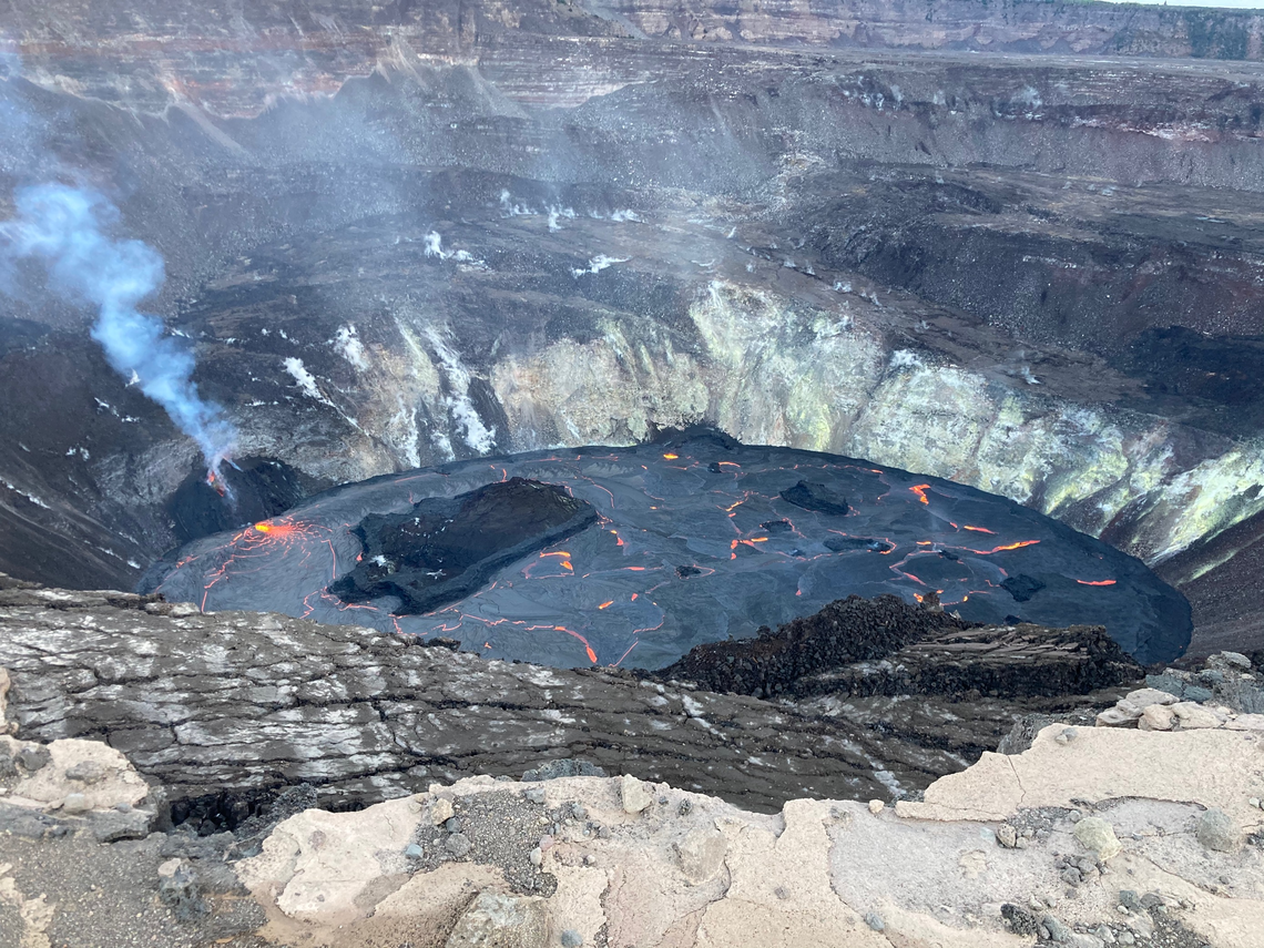
HVO scientists continue to monitor the eruption in Halema‘uma‘u crater at Kīlauea Volcano’s summit. This morning (Jan. 2) at approximately 7:10 a.m. HST the lava lake depth was measured at about 189 m (620 ft), which has not changed significantly since yesterday afternoon. The spatter cone, that was built by the now inactive northern vent (center), is almost downed by the slowly rising lava lake within Halema‘uma‘u.
Over the past day, the main island of cooler, solidified lava floating in the lava lake drifted to the west before settling in front of the west lava source filling the lake around midnight, while the other 10 or so small islands remained relatively stationary around the east end of the lake. The main island measured about 250 m (820 ft) in length, 135 m (440 ft) in width, and about 3 ha (7 acres) in area based on the Dec. 30 thermal map. Measurements Friday afternoon (Jan. 1) showed that the island surface was about 6 m (20 ft) above the lake surface.
Source : HVO.
Indonesia , Merapi :
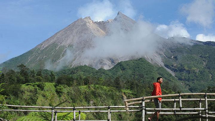
Level of activity at level III (SIAGA) since November 5, 2020 at 12:00 WIB. The Merapi volcano (2968 m above sea level) is continuously erupting. The last eruption took place on June 21, 2020 with the height of the eruption column at 6000 m above the summit. It was observed that the color of the ash column was gray.
The volcano was clear until it was covered in fog. Smoke from the crater was observed from 70 to 450 m above the summit, white in color and moderate to thick in intensity. The weather is cloudy to rainy, with weak to strong winds to the east and southeast. The sound of the avalanches was heard at the PGA Babadan station with low to moderate intensity.
According to the seismographs of January 2, 2021, it was recorded:
● 92 avalanche earthquakes
● 119 earthquakes of emissions
● 467 hybrid / multi-phase earthquakes
● 100 shallow volcanic earthquakes.
After the emergency response period ended on November 30, Sleman Regency extended it until December 31, 2020. Now it has been extended again from January 1 to January 31, 2021.
« Based on the report of the activities of the Merapi of the BPPTKG (Research and Development Center on Geological Disaster Technology) from December 18 to 24, 2020, the state of the volcano was at alert level 3, » said Regional Disaster Mitigation Agency Acting Head of Sleman Regency Joko Supriyanto on Saturday, January 2, 2021.
The active volcano has the potential to emit lava, volcanic material and hot clouds. Joko said 240 people from Mount Merapi areas are still being resettled in Glagaharjo, Cangkringan, and they need help from the regional government to meet their basic needs.
Source : PVMBG. TEMPO.
Photo : Tempo .
Ecuador , Sangay :
DAILY REPORT ON THE STATE OF SANGAY VOLCANO, Saturday January 02, 2021.
Surface activity level: High, Surface trend: Increasing.
Internal activity level: High, Internal trend: Increasing.
Seismicity: From January 01, 2021, 11:00 to January 02, 2021, 11:00:
Long period type events (LP): 8
Explosions (EXP): 120
Rains / lahars:
During the night from Saturday to Sunday, moderate rains were recorded, which probably generated the descent of lahars.
** In case of heavy rains, lahars can be generated in the Volcán, Upano rivers and other tributaries **

Ash Emission / Column: Using satellite imagery, the VAAC reported several ash emissions in the past 24 hours, which reached 1,470 meters above the summit. Their direction varied between southwest and west.
Other monitoring parameters: No changes
Observations: The area remained completely cloudy.
Alert level: yellow.
Sources : INSTITUT GÉOPHYSIQUE / ÉCOLE NATIONALE DE POLYTECHNIQUE.
Photo : Yong Soo Seung.
Mexico , Popocatepetl :
January 02, 11:15 a.m. (January 02, 5:15 p.m. GMT)
During the last 24 hours, according to the monitoring systems of the Popocatépetl volcano, 77 exhalations and 1020 minutes of tremor have been identified, accompanied by emissions of volcanic gases and ash. Sometimes the column had a maximum height of 500 m and was dispersed mainly towards the northeast. In addition, an explosion was recorded yesterday at 7:04 p.m. accompanied by the expulsion of incandescent fragments that were deposited on the rim of the crater.
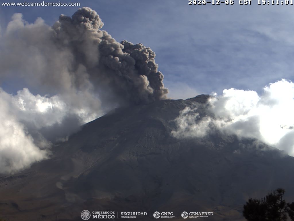
In the early morning and at the time of this report, emissions of volcanic gases and ash are observed, which are scattered in a northeast direction.
CENAPRED urges NOT TO APPROACH the volcano and in particular the crater, because of the danger posed by the fall of ballistic fragments and, in the event of heavy rains, to stay away from the bottom of the ravines because of the danger of flows. mud and debris.
The Popocatépetl volcanic alert semaphore is in YELLOW PHASE 2.
Source : Cenapred .
Photo : Archive cenapred.