May 06 , 022.
Indonesia , Ibu :
VOLCANO OBSERVATORY NOTICE FOR AVIATION – VONA
Issued : May 05 , 2022
Volcano : Ibu (268030)
Current Aviation Colour Code : ORANGE
Previous Aviation Colour Code : orange
Source : Ibu Volcano Observatory
Notice Number : 2022IBU31
Volcano Location : N 01 deg 29 min 17 sec E 127 deg 37 min 48 sec
Area : North Maluku, Indonesia
Summit Elevation : 4240 FT (1325 M)

Volcanic Activity Summary :
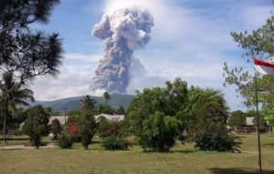
Eruption with volcanic ash cloud at 09h25 UTC (18h25 local).
Volcanic Cloud Height :
Best estimate of ash-cloud top is around 7440 FT (2325 M) above sea level, may be higher than what can be observed clearly. Source of height data: ground observer.
Other Volcanic Cloud Information :
Ash-cloud moving to west.
Remarks :
Eruption and ash emission is continuing.
Source : Magma Indonésie .
Photo : PVMBG.
New Zealand , Ruapehu :
The temperature of the water in Ruapehu’s crater lake has risen again and GNS Science is keeping a close eye on what this might mean for the risk of a substantial eruption.
The agency’s duty volcanologist Geoff Kilgour said Friday it’s pretty much steady as she goes ahead of the weekend with the volcanic alert status at Ruapehu unchanged at 2.
But the temperature rise is being monitored closely for a range of reasons.
Kilgour’s explanation illustrates the scientific skill needed to assess the risk of an eruption of volcanic material and ash. He said the temperature of the crater lake, Te Wai a-moe, has gone up from 39 degrees Celsius to 40 C since Tuesday’s last volcanic alert level bulletin.
This wasn’t so concerning on its own as it was continuing a trend that started earlier in the week. But whether the rise meant more or less risk of an eruption wasn’t certain, Kilgour said.
The temperature rise did indicate there was more volcanic fluid and gas coming into the lake, which acts as a cap that helps prevent eruptions of material and ash.
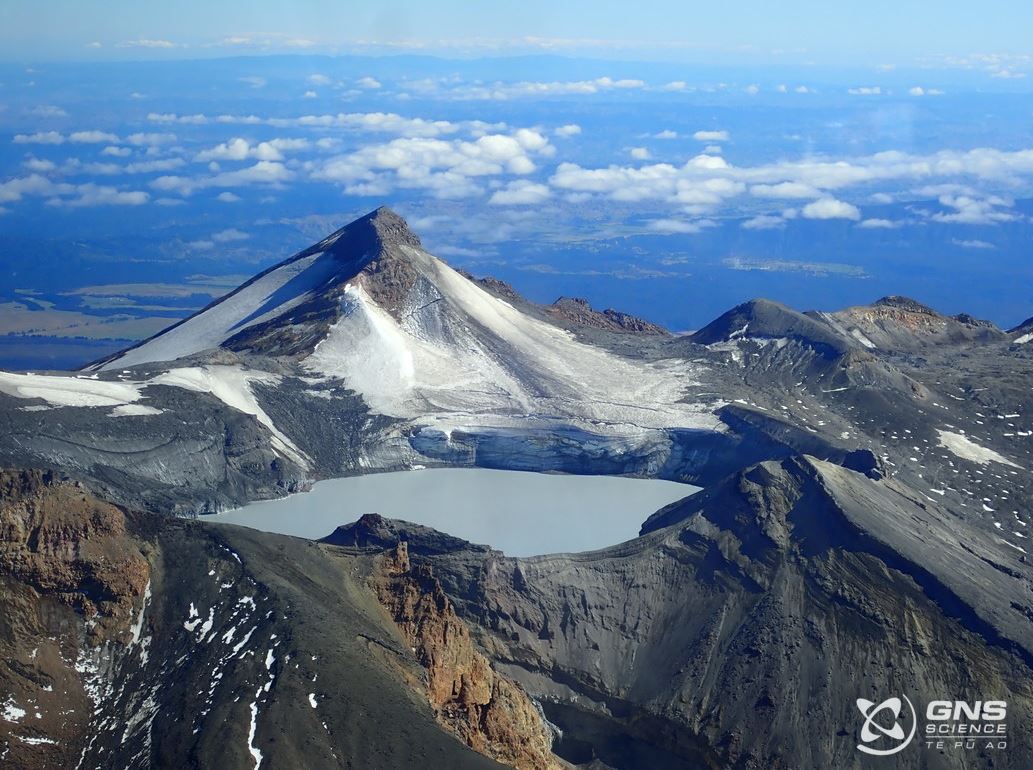
The larger central vent opened only recently for the first time in the latest round of more significant activity at Ruapehu. That central vent is the main source of volcanic fluid and gas heating the water. Central vent [produces] a really large bubble, tens of metres across, » said Kilgour.
On whether the slow warming increased the risk of an actual eruption, Kilgour said: « That’s a tricky one. »
The fact that central vent was open could help ease pressure below the lake as “it’s releasing some of the pressure there”. That pressure reduction could cut the risk of an eruption.
But, on the other hand, the fact central vent was open could also mean hot volcanic magma may rise towards the waters of the lake, resulting in the production of more steam and ejection of water.
Given the lake acts as a cap helping stop explosions of volcanic material and ash, any resulting significant lowering of the lake’s water level would be of concern.
« Then we might see larger eruptions start to happen, » said Kilgour.
GNS Science said this week that the chances of a prolonged eruptive episode or a larger eruption, such as occurred in 1995-96 with wider ashfall impacts, is higher than it was two months ago but remains very unlikely. Such an eruption would most likely only follow a sequence of smaller eruptions.
Source : stuff.co.nz
Photo : Geonet.
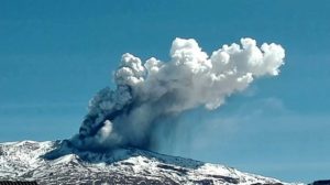
Italy , Vulcano :
WEEKLY BULLETIN, from April 25, 2022 to May 01, 2022. (issue date May 03, 2022)
ACTIVITY STATUS SUMMARY
In the light of the surveillance data, it is highlighted:
1) Temperature of the crater fumaroles: The temperatures recorded on the rim of the crater show stable values at high levels
2) CO2 flux in the crater area: The latest measurements show high values.
3) SO2 flux in the crater area: SO2 flux at a medium-high and stable level
4) Geochemistry of fumarolic gases: No update is available: the last sampling of March 31 confirmed the downward trend in the concentration of magmatic gases in the fumaroles of Vulcano.
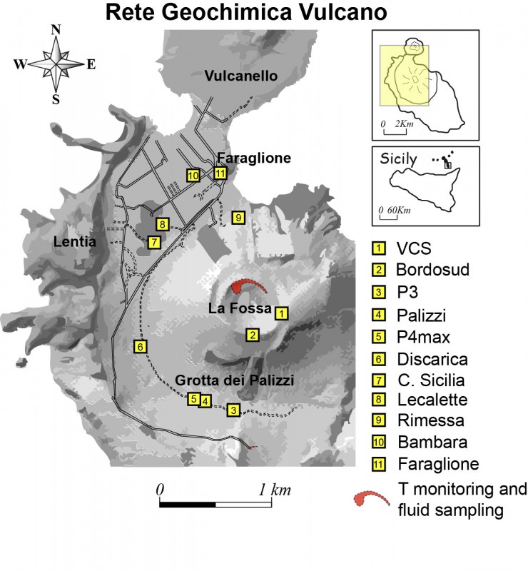
5) CO2 fluxes at the base of the La Fossa cone and in the Vulcano Porto area: The CO2 fluxes recorded in the C. Sicilia, Rimessa and P4max sites continue to show a slight downward trend, but remain on medium-high values; in the Faraglione site there are values close to the background.
6) Geochemistry of thermal aquifers: The temperature measured in the Camping Sicilia well is at high and stable values. The electrical conductivity shows low values, although slightly increasing.
The level values measured in the Bambara well show a moderate upward trend. Conductivity values continue to show a gradual decrease even though they remain at medium-high levels.
7) Local seismicity: low level of local seismic activity
8) Regional seismicity: low seismic fracturing activity.
9) Deformations – GNSS: The network of permanent GNSS stations has not recorded any significant changes.
10) Deformations – Inclinometry: The inclinometric network has not recorded any significant changes.
11) Other observations: Monthly CO2 flux campaign: a clear decrease in CO2 emissions is observed in the Vulcano Porto area; however, average soil CO2 emissions still remain at abnormal levels.
Monthly drilling campaign: there is a stabilization of the supply of fluids of fumarolic origin to the thermal aquifer, which still remains at abnormal levels.
Gravimetry: No significant changes were recorded during the period considered.
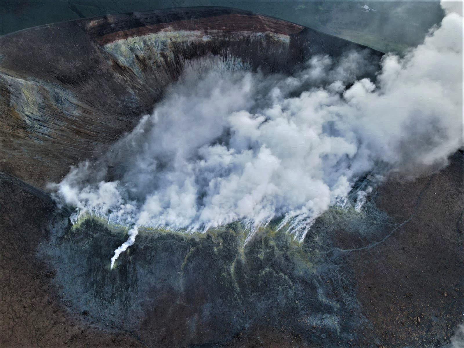
CRATER FUMEROLES TEMPERATURE:
Along the upper edge, the maximum emission temperature has very stable values (T1: 382-383°C), with a weekly average of 383°C (hourly data recorded between April 26 and May 3). The fumarole field has equivalent emission temperatures over the entire summit fracture line, confirming a thermal anomaly still maintained by a constant vapor flow: fumarole F5 (sensor T3) showed emission temperatures (T MAX 377; min 376°C) superimposed on the temperatures of sensor T2 placed in F5AT, up to the date of the failure (April 28).
The maximum temperature recorded at the level of the sensor placed on the internal slope was 111°C, but the site is disturbed by exogenous effects.
CO2 FLOW AT THE BASE OF LA FOSSA CONE AND IN THE VULCANO PORTO AREA
The CO2 fluxes at the base of the crater in the C. Sicilia site show average to high values, above the background, although in sharp decrease compared to the November-December 2021 period; average values were recorded on the Rimessa site, stable compared to last week; the P4max site displays medium-high values, which fluctuate cyclically; in the Faraglione site there are values close to the background level
Source : INGV.
Photos : INGV , INGV-Roma1 .
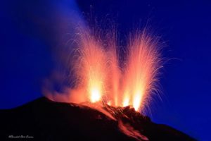
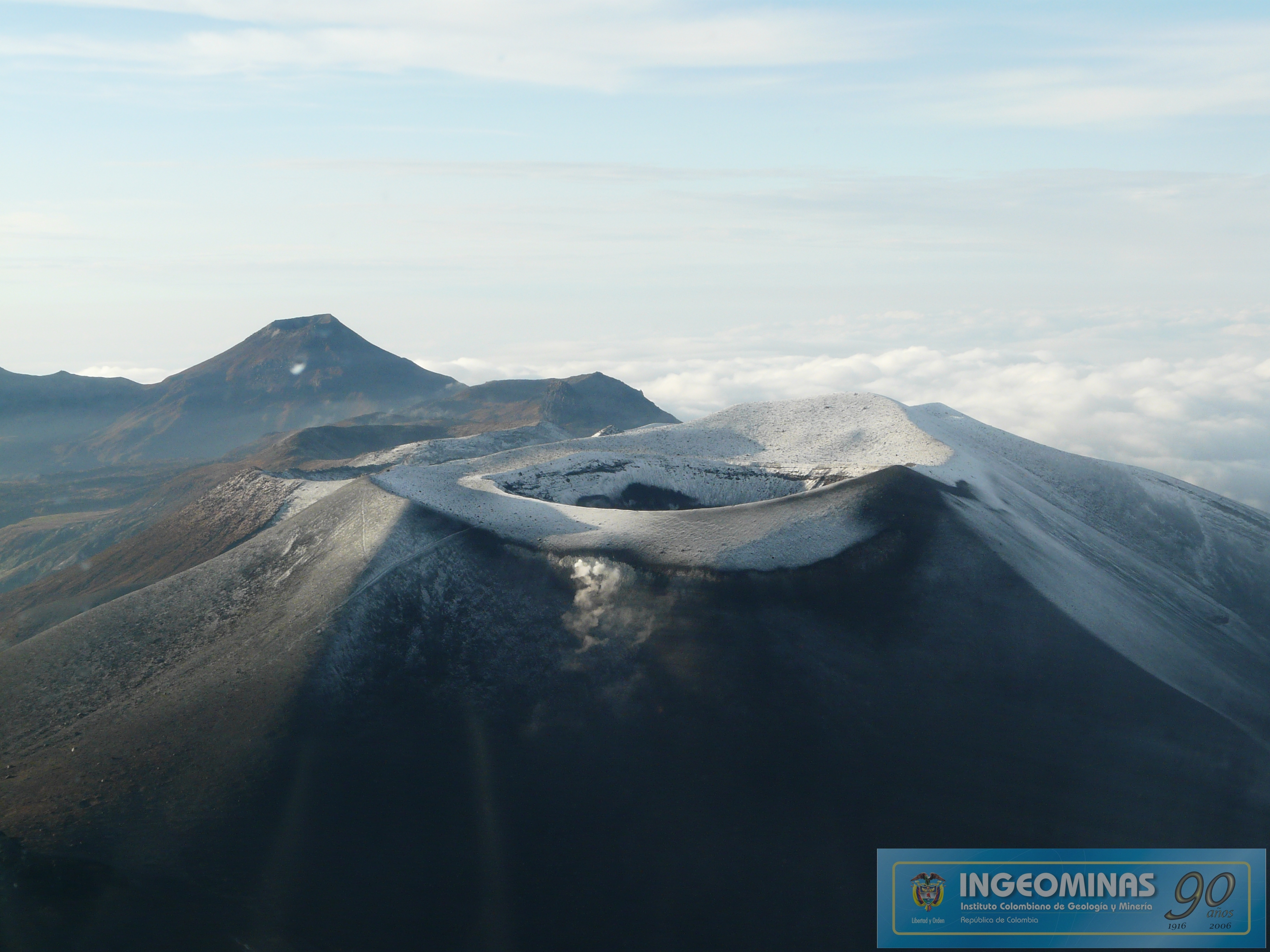
Colombia , Puracé :
Weekly bulletin of the activity of the Puracé volcano – Los Coconucos volcanic chain
The activity level of the volcano continues at the Yellow activity level or (III): changes in the behavior of volcanic activity.
From the analysis and evaluation of the information obtained through the monitoring network of the Puracé volcano – Los Coconucos volcanic chain, during the week of April 26 to May 2, 2022, the COLOMBIAN GEOLOGICAL SERVICE – Volcanological and Seismological Observatory de Popayán informs that:
Regarding the number and released energy of recorded seismic events, a stable behavior was observed, compared to previous weeks. For the period evaluated, 464 seismic events were recorded, of which 67 were associated with rock fracturing processes (type VT) and 397 with fluid dynamics in volcanic conduits; Of these, 357 were classified as long period type events (LP type), six (6) hybrid type (HB) events, 13 low frequency events (BF type) and 21 as low input tremor pulses. energy (type TR).
The geodetic network of GNSS (Global Navigation Satellite System) stations for monitoring ground deformation continues to record a process associated with inflation.
Regarding volcanic gas monitoring, sulfur dioxide (SO2) flux emissions recorded by telemetry and field stations show an increase compared to the previous week, reaching flow values in the mobile instrument of 2011 t/day for April. 28 and a throughput in permanent stations with a maximum emitted of 2409 t/day. The other gas analysis instruments in the volcanic influence zone do not show any relevant changes for the evaluated period.
In the monitoring of surface activity, images were obtained during the week thanks to the Mina, Lavas Rojas and Cerro Sombrero web cameras, which showed degassing of the volcanic system, with a white column oriented preferentially towards the North -West.
Sensors monitoring magnetic and electric fields and infrasonic waves did not record variations associated with changes in volcanic activity.
Therefore, it is concluded that significant variations in volcanic activity continue to be recorded, in accordance with the behavior expected at activity level III (yellow level), which could evolve towards states of greater activity. The Colombian Geological Service continues to monitor the evolution of the volcanic phenomenon and will report any changes that may occur in due course.
Source : SGC.
Photo : Ingeominas.
Ecuador / Galapagos , Wolf :
APPARENT END OF THE ERUPTIVE PERIOD.
The Wolf volcano (height: 1710 m) located in the northern part of Isabela Island in the Galapagos archipelago, began a new eruptive period at 11:20 p.m. on January 6, 2022, Galapagos time (00:20 on January 7, 2022, Galapagos time). mainland of Ecuador). The evolution of this eruption was monitored by seismic stations and different satellite systems, thanks to which it was possible to check mainly the emission and the advance of the lava flows, as well as the emissions of volcanic gases.
The lava flows were emitted from an approximately 8 km radial fissure with at least 5 vents located on the southeast flank of the volcano. The lavas flowed to a maximum distance of about 18.5 km, without having reached the coastal margin (Figure 1) and covered an approximate area of more than 30 km2.
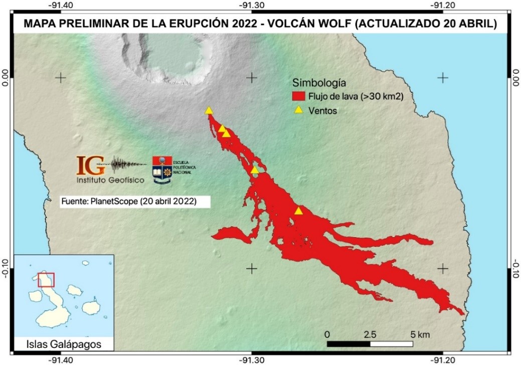
Preliminary map of lava flows emitted during the eruption of the Wolf volcano which began in January 2022 (Galapagos Islands). The map was made based on satellite images from PlanetScope. It can be observed that the lava flows covered an area of more than 30 km2, and that their maximum distribution area was about 18.5 km from the highest vent, without having reached the coastal margin (F.J. Vasconez).
Hundreds of satellite thermal alerts were recorded daily based on the location of these lava flows. However, these alerts have gradually decreased in recent days until they are almost absent, which is interpreted as a decrease in the emission rate of lava flows and a significant cooling of them. Likewise, the degassing of sulfur dioxide (SO2) shows a downward trend, so that at the date of this report, a month has already passed without reports of SO2 emissions.
Findings:
The monitoring parameters that allow us to assess the evolution of the eruption are: seismic activity, degassing, deformation, thermal alerts, ash emissions. These parameters reached their maximum peak in early January 2022, after which they decreased until returning to baseline (non-eruptive) values. At present, thanks to satellite images, there is no advance of the lava fronts, which seem to have stopped 150-200 meters from the coast and have been gradually cooled.
Based on the technical criteria set out above, this eruptive period is considered to be over. The IG-EPN remains attentive to the possible changes that the Wolf volcano could present and will inform in a timely manner through its official communication channels.
Source : IGEPN.
Read the full article: https://www.igepn.edu.ec/servicios/noticias/1931-informe-especial-volcan-wolf-no-2022-003
Hawaii , Kilauea :
19°25’16 » N 155°17’13 » W,
Summit Elevation 4091 ft (1247 m)
Current Volcano Alert Level: WATCH
Current Aviation Color Code: ORANGE
Activity Summary:
The summit eruption of Kīlauea Volcano, within Halemaʻumaʻu crater, has continued over the past 24 hours. All recent lava activity has been confined to the crater, and current data indicate that this scenario is likely to continue. No significant changes have been noted in the summit or East Rift Zone.
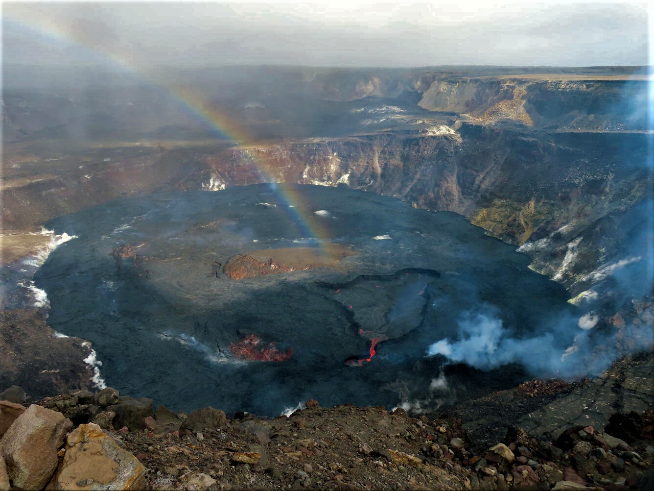
Halemaʻumaʻu crater Lava Lake Observations:
Eruption of lava from the Halemaʻumaʻu western vent into the active lava lake and onto the crater floor has continued over the past 24 hours. The active lava lake has experienced continuous surface activity, and its surface level has been relatively steady over this period. Yesterday saw the continuation of relatively sluggish lava ooze-outs along the northeastern and southern margins of the crater floor, and this morning a particularly vigorous and expansive ooze-out began along the northwestern margin just after 2:00 a.m. Overflight measurements on April 6, 2022 indicated that the crater floor had seen a total rise of about 99 meters (325 feet) and that 66 million cubic meters (18 billion gallons) of lava had been effused since the beginning of this eruption on September 29, 2021.
Summit Observations:
Summit tiltmeters began tracking sharp deflationary tilt around 5:00 a.m. this morning, which continues at this time. Volcanic tremor remains above background levels. A sulfur dioxide (SO2) emission rate of approximately 2,600 tonnes per day (t/d) was measured yesterday, May 4, 2022.
Source : HVO.
Photo : USGS / K. Lynn