Hope you had the best Christmas possible.
December 27 , 2020.
Hawaii , Kilauea :
19°25’16 » N 155°17’13 » W,
Summit Elevation 4091 ft (1247 m)
Current Volcano Alert Level: WATCH
Current Aviation Color Code: ORANGE
Activity Summary:
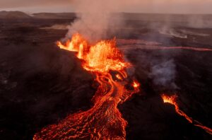
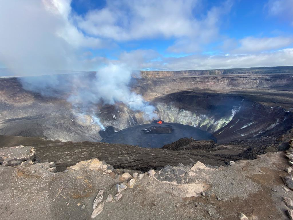
Lava activity is confined to Halemaʻumaʻu from two vents on the north and northwest sides of the crater. As of 2 pm yesterday, the crater lake was still 176 m (577 ft) deep and the lake level appeared to be 2 m (6 ft) lower leaving a narrow black ledge around the north edge. Early this morning, the west vent reactivated while the north vent quieted and started to drain the lake. Reduced SO2 emissions were measured last night.
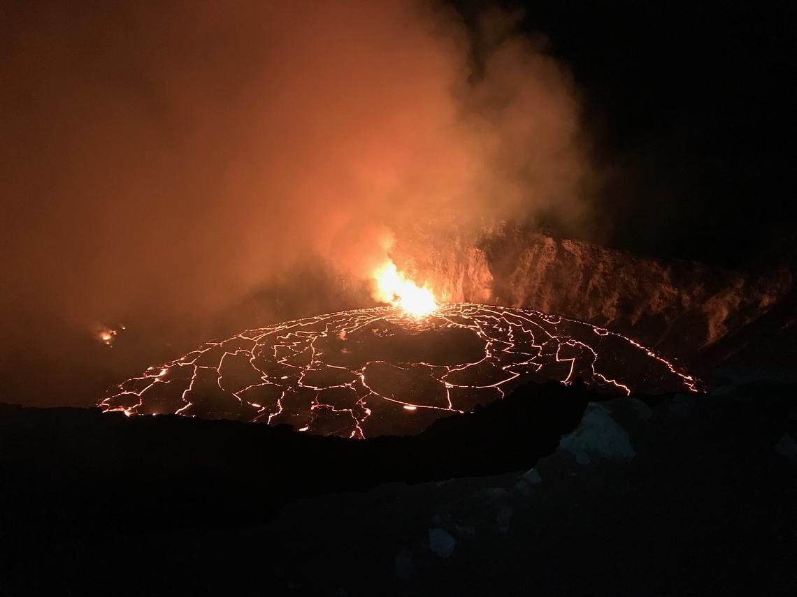
An early December 25, 2020, morning view of the ongoing eruption in Halema‘uma‘u crater at Kīlauea’s summit. Overnight fountaining continued to feed the rising lava lake, which slowly fills Halema‘uma‘u. This photo, taken at approximately 2:30 a.m. from the south rim of the crater, shows the main northern vent that is being drowned by the rising lava lake. Intermittent activity continues at the weaker west vent.
Summit Observations:
Preliminary analysis of sulfur dioxide emission rates measured last night suggest that the rates have dropped to 16,000-20,000 tonnes/day. Summit tiltmeters continued to record slowing deflationary tilt until just before 3 am this morning (Dec. 26) when it switched to inflationary tilt. Seismicity remained elevated but stable, with a few minor earthquakes and tremor fluctuations related to the vigor of fissure fountaining.
Halemaʻumaʻu lava lake observations:
The north vent continued erupting lava into a lake within Halemaʻumaʻu crater. The west vent was incandescent until about 2:40 am this morning (nearly coincident with the switch from deflationary to inflationary summit tilt) when it became vigorously active with up to 3 narrow lava streams into the lake . After 3 am the north vent quieted and started to slowly drain lava from the lake.
The lava lake within Halemaʻumaʻu crater remained about 176 m (577 ft) deep and about 415 m (1,360 ft) below the Halemaʻumaʻu rim as of yesterday afternoon (Dec. 25th). The lava lake volume remained about 21 million cubic meters (27 million cubic yards or 4.8 billion gallons). USGS field crews are currently making measurements to confirm whether the lake surface continues to drop.
An island of cooler, solidified lava floating in the lava lake, which has been drifting slowly northeastward in the lake, has apparently grounded itself near the north vent. It is still about 260 m (850 ft) in length and 115 m (375 ft) in width based on the Dec. 23rd thermal map . At about 6 am this morning (Dec. 26), the island started to slowly drift to the southeast.
The Halema‘uma‘u crater at Kīlauea summit continues to slowly fill with lava from the ongoing eruption. As the lava lake rises, it gradually drowns more of the northern fissure. The western fissure activity continues to weaken, and field crews are reporting that only rare intermittent spattering is visible.
Hazard Analysis:
High levels of volcanic gas, rockfalls, explosions, and volcanic glass particles are the primary hazards of concern regarding this new activity at Kīlauea’s summit. Large amounts of volcanic gas—primarily water vapor (H2O), carbon dioxide (CO2), and sulfur dioxide (SO2)—are continuously released during eruptions of Kīlauea Volcano. As SO2 is released from the summit during this new eruption, it will react in the atmosphere with oxygen, sunlight, moisture, and other gases and particles, and within hours to days, convert to fine particles. The particles scatter sunlight and cause the visible haze that has been observed downwind of Kīlauea, known as vog (volcanic smog), during previous summit eruptions. Vog creates the potential for airborne health hazards to residents and visitors, damages agricultural crops and other plants, and affects livestock operations.
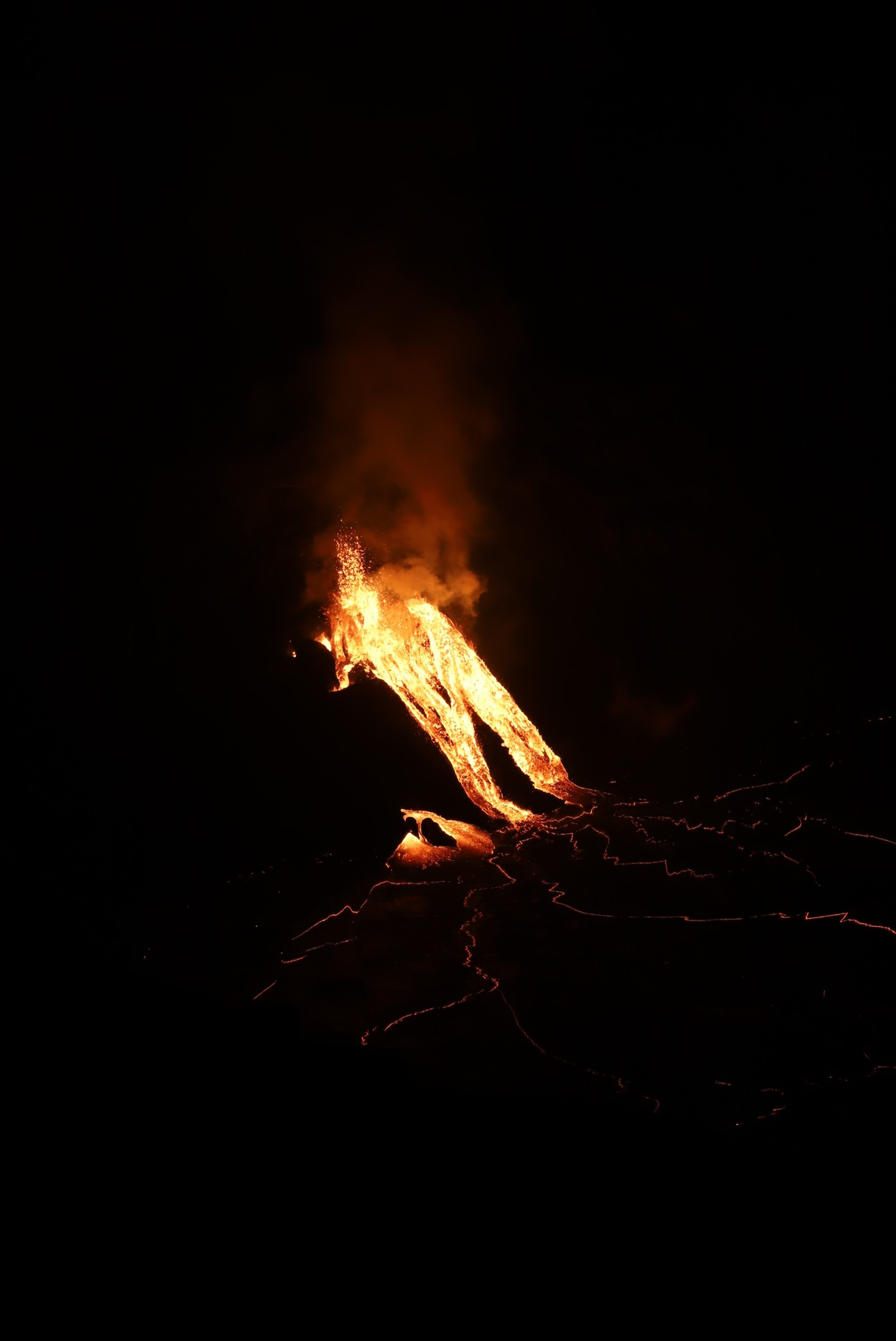
As of about 2:40 a.m. HST on December 26, 2020, activity at the west vent in Halema‘uma‘u crater wall at Kīlauea’s summit has increased. This photo, taken at approximately 5:15 a.m. HST shows fountaining at the west vent, and lava pouring from the north end of the fissure into the growing lava lake. HVO field crews monitoring the activity overnight measured the west vent lava fountains as at least 10 m (32 ft) high.
Rockfalls and minor explosions, such as the ones that occurred during the 2008–2018 lava lake eruption at Kīlauea summit, may occur suddenly and without warning. This underscores the extremely hazardous nature of Kīlauea caldera rim surrounding Halemaʻumaʻu crater, an area that has been closed to the public since late 2007. Pele’s hair and other lightweight volcanic glass fragments from the lava fountains within Halemaʻumaʻu will fall downwind of the fissure vents and lava lake, dusting the ground within a few hundred meters (yards) of the vent. High winds may waft lighter particles to greater distances. Residents are urged to minimize exposure to these volcanic particles, which can cause skin and eye irritation similar to volcanic ash.
Source : HVO
Photos : USGS photo by J. Schmith and C. Parcheta. , USGS photo taken on December 25 by F. Trusdell. USGS photo H. Dietterich.
Chile , Cerro Hudson :
– During the period, 274 earthquakes classified as being of volcano-tectonic (VT) type were recorded, associated with the fracturing of rigid materials; the event with the highest energy had a local magnitude (ML) of 2.9 and was located 4.7 km east-southeast (ESE) of the caldera center with a depth of 4.6 km. It should be noted that a significant part of this seismicity was recorded during the occurrence of 2 seismic swarms (generation of seismicity over a short period) which occurred on December 10 and 11.
– Similarly, 36 seismic events of the long period (LP) type were classified, seismicity linked to the dynamics of fluids inside the volcanic building and / or produced by glacial activity; the most important earthquake presented an energy evaluated from the parameter of reduced displacement (DR) equal to 29.6 cm2.
– In addition, 5 earthquakes classified as hybrid (HB) were recorded, commonly linked to a mechanism composed of a fracturing of rigid material and a subsequent disturbance due to the circulation of fluids inside the volcanic conduits . The earthquake with the highest energy exhibited a local magnitude (ML) equal to 3.1, which was located 4.0 km south-southeast (SSE) of the caldera center at a depth of 4.3 km.
– According to the data provided by 2 GNSS stations which make it possible to measure the surface deformation in the volcanic sectors, there are no variations suggesting changes in the internal dynamics of the volcano.
Chile’s second largest explosive eruption of the 20th century began on August 8, 1991 from a fissure cutting the western rim of Cerro Hudson caldera. The paroxysmal phase began on August 12 and was sustained for three days, producing ashfall that collapsed roofs near the volcano and fell in the Falkland Islands, 1000 km to the SE. Pyroclastic flows were mostly restricted to the caldera floor. The dark streak at the lower right-center is a lava flow that traveled 4 km down the WNW flank from the west caldera rim fissure.
In recent weeks, the Hudson volcano has shown an obvious change in its seismic activity, represented by an increase in volcanic seismicity (VT, HB and LP), both in the rate of occurrence and in the value of energies. More precisely, during the first half of December, the aforementioned increase reached values that exceed the base threshold of this volcano, as is the case of the earthquake of local magnitude (ML) equal to 3.1 that occurred December 10. The locations associated with the earthquakes suggest a relatively shallow spring located southeast (SE) of the caldera. Although other volcanic parameters are always considered as normal values, the occurrence of the aforementioned seismic activity allows to deduce a greater dynamics inside the volcanic conduits. Based on the above, the technical alert level turns yellow.
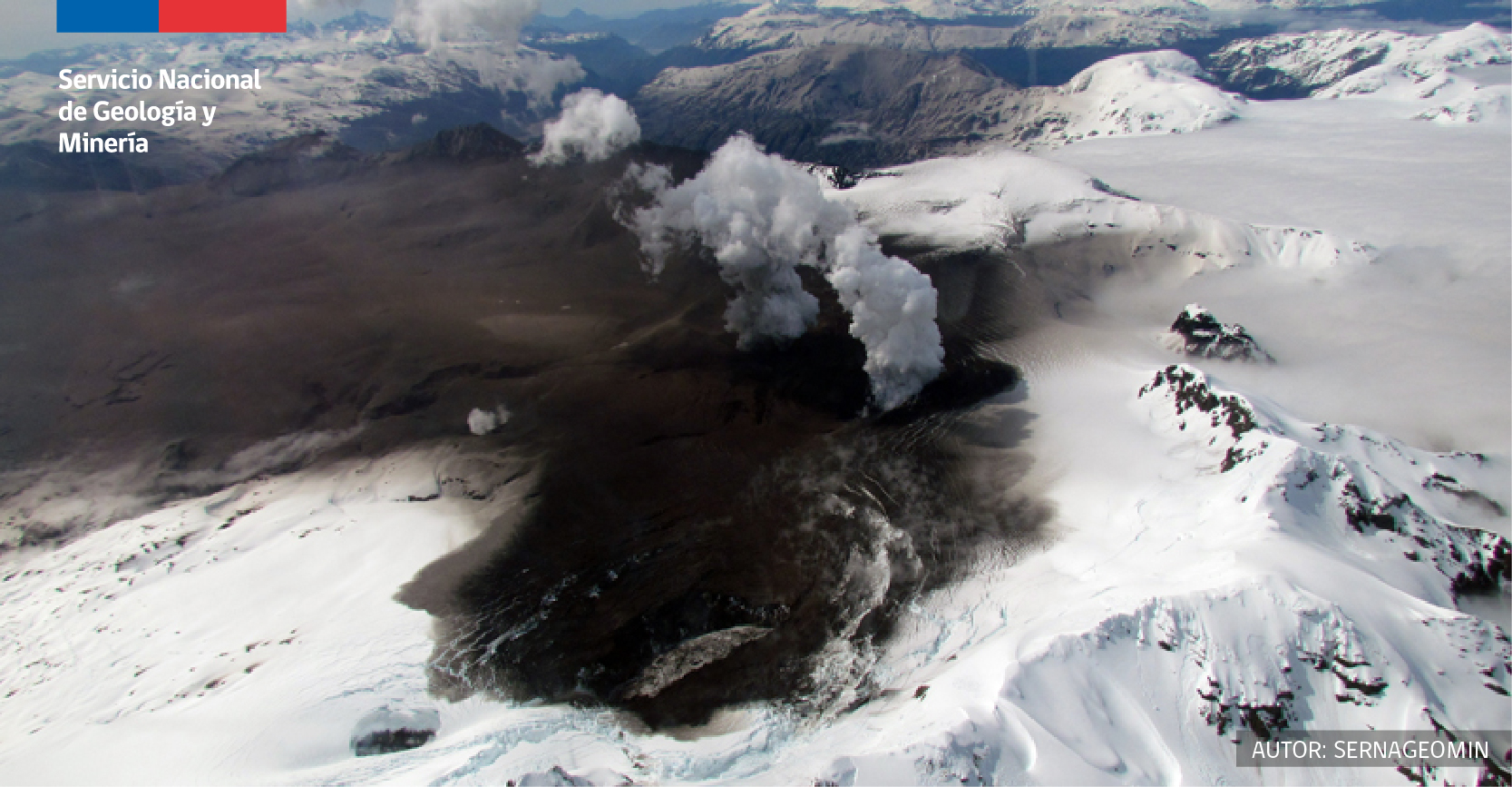
The ice-filled, 10-km-wide caldera of the remote Cerro Hudson volcano was not recognized until its first 20th-century eruption in 1971. It is the southernmost volcano in the Chilean Andes related to subduction of the Nazca plate beneath the South American plate. The massive volcano covers an area of 300 km2. The compound caldera is drained through a breach on its NW rim, which has been the source of mudflows down the Río de Los Huemeles. Two cinder cones occur N of the volcano and others occupy the SW and SE flanks. This volcano has been the source of several major Holocene explosive eruptions. An eruption about 6700 years ago was one of the largest known in the southern Andes during the Holocene; another eruption about 3600 years ago also produced more than 10 km3 of tephra. An eruption in 1991 was Chile’s second largest of the 20th century and formed a new 800-m-wide crater in the SW portion of the caldera.
Source : Sernageomin . GVP.
Photo : Norm Banks, 1991 (U.S. Geological Survey). Sernageomin .
Guatemala , Pacaya :
SPECIAL VOLCANOLOGY BULLETIN
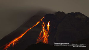
As indicated in previous special bulletins, the activity of the Pacaya volcano has increased, being effusive in nature. The lava flow reported from the middle part of the volcano in a West-South-West direction is still active and has several branches (between 5 to 7 branches), with a length of between 600 and 750 meters, approximately. From this crack, a degassing is recorded in white and blue tones and other magmatic gases. This active zone is maintained at high temperatures and is quite unstable.
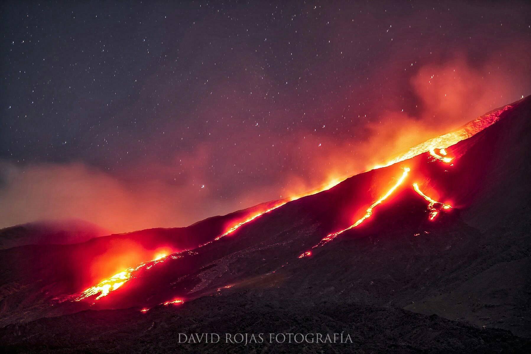
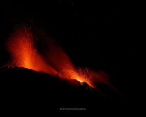
There are also periods of audible moderate Strombolian explosive activity that release material up to 100 meters above the crater, some of which generate rumblings and ballistic projections within a radius of about 50 meters. There is also an incandescence and degassing in the Mackenney crater, which emits an eruptive column of up to 600 meters above the crater which disperses in the direction of the wind, which causes ash falls in the environment.
INSIVUMEH provides visual and instrumental monitoring, through seismic stations (PCG and PCG5) and OVPAC observers.
Source : Insivumeh .
Photo : David Rojas.
Kamchatka , Klyuchevskoy :
VOLCANO OBSERVATORY NOTICE FOR AVIATION (VONA).
Issued: December 25 , 2020
Volcano: Klyuchevskoy (CAVW #300260)
Current aviation colour code: ORANGE
Previous aviation colour code: orange
Source: KVERT
Notice Number: 2020-254
Volcano Location: N 56 deg 3 min E 160 deg 38 min
Area: Kamchatka, Russia
Summit Elevation: 15580 ft (4750 m)
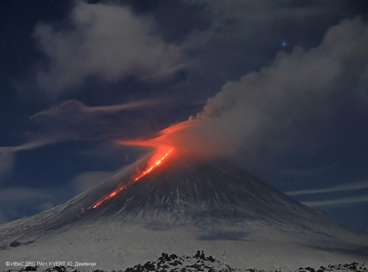
Volcanic Activity Summary:
A moderate explosive-effusive eruption of the volcano continues. According to video and satellite data, a gas-steam plume with some amount of ash is extending for 60 km to the northeast of the volcano.
A moderate explosive-effusive eruption of the volcano continues. Ash explosions up to 23,000-26,200 ft (7-8 km) a.s.l. could occur at any time. Ongoing activity could affect low-flying aircraft.
Volcanic cloud height:
19680 ft (6000 m) AMSL Time and method of ash plume/cloud height determination: 20201225/2320Z – Video data
Other volcanic cloud information:
Distance of ash plume/cloud of the volcano: 31 mi (50 km)
Direction of drift of ash plume/cloud of the volcano: NE
Time and method of ash plume/cloud determination: 20201225/2100Z – Himawari-8
Source : Kvert
Photo : Yu. Demyanchuk. IVS FEB RAS, KVERT