September 28 , 2022.
La Réunion , Piton de la Fournaise :
Press release, Paris Institute of Earth Physics, Piton de la Fournaise Volcanological Observatory, September 27, 2022 – 4:00 p.m. (local time) – 12:00 p.m. (UTC time).
Ongoing eruption
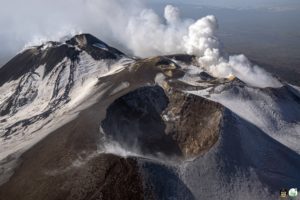
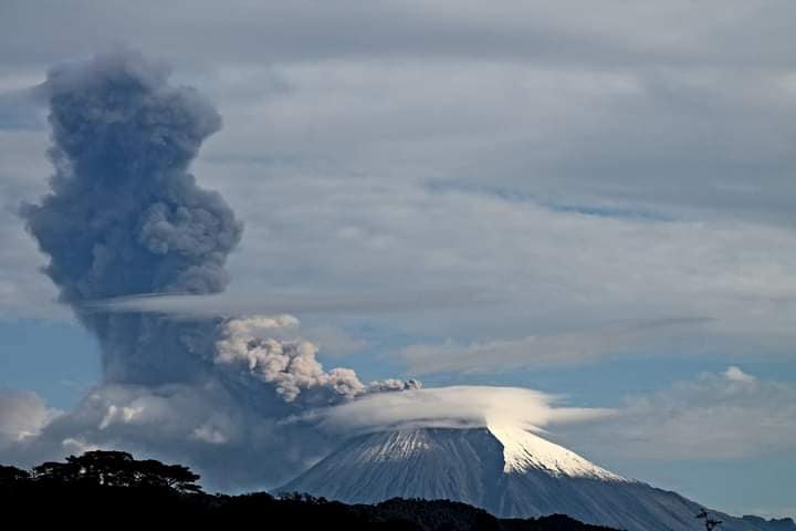
The eruption started on 09/19/2022 around 07:48 local time continues. The amplitude of the eruptive tremor (indicator of surface lava emission) has remained generally stable over the past 24 hours, at around 20% of its initial amplitude (Figure 1).
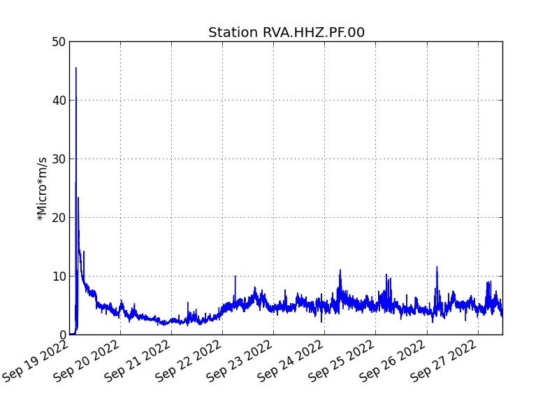
Evolution of the RSAM (indicator of a surface lava emission) since 09/19/2022 00:00 UTC time (04:00 local time) on the RVA seismological station located at the Rivals crater (© OVPF / IPGP).
– No volcano-tectonic earthquake has been recorded directly above the summit area over the past 24 hours.
– A slight inflation (swelling) of the summit zone of the volcano seems to be emerging, this parameter will be confirmed in the coming days.
The lava flow estimates established by satellite method on the HOTVOLC (OPGC – Clermont Auvergne University) and MIROVA (University of Turin) platforms indicate an average flow over the last 24 hours that is relatively stable and low around 2 m3/s with a peak maximum estimated at 7 m3/s.
The acquisitions of the COPERNICUS program developed by the European Commission provide images of the TROPOMI instrument intended for the observation of the composition of the atmosphere, and in particular the concentrations of SO2. The September 27 (09:20 UTC) image indicated a weak gas plume still oriented to the west and detected up to about 200 km from the source. The integrated mass of SO2 visible in the image is estimated between 0.2 kton (processing at 7 km altitude) and approx. 2 kton (treatment at 1 km altitude).
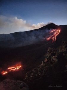
The observations of the OVPF-IPGP teams in the field show for today an activity similar to the previous days, namely:
– still significant degassing at the eruptive site and low-amplitude lava projections ;
– a gas plume still directed westward as is also visible on the satellite data ;
– a lava flow activity still mainly through lava tunnels;
– resurgences of lava visible at the level of the tunnels.
Alert level: Alert 2-1 (Access to the Enclos prohibited; eruption in the Enclosure without any particular threat to the safety of persons, property or the environment)
Source : Direction OVPF / IPGP.
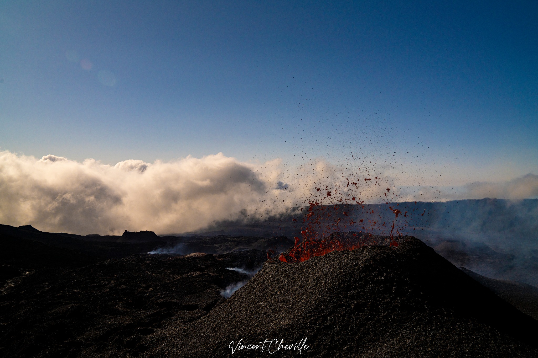
Source : Vincent Cheville / tunnel de lave réunion.
Italy , Stromboli :
WEEKLY BULLETIN, from September 19, 2022 to September 25, 2022, (issue date September 27, 2022)
ACTIVITY STATUS SUMMARY
In the light of the surveillance data, it is highlighted:
1) VOLCANOLOGICAL OBSERVATIONS: During this period, a normal Strombolian-type explosive activity was observed with spattering activity and an effusive event from the N crater area. The total hourly frequency oscillated on low values (4 events /h) and medium-low values (9 events/h). The intensity of the explosions was low and medium in the North crater area while it was medium in the Center-South crater area.
2) SEISMOLOGY: The seismological parameters monitored do not show any significant variations.
3) GROUND DEFORMATIONS: The ground deformation monitoring networks did not reveal any significant variations.
4) GEOCHEMISTRY: SO2 flux at an average level
The flux of CO2 from the soils in the summit zone is at medium to high values.
The C/S ratio in the plume is placed on medium-high values (11.25).
Isotope ratio of dissolved Helium in heat sinks: there is no update since the sampling of September 07, 2022.
5) SATELLITE OBSERVATIONS: The thermal activity observed by satellite in the summit area was weak.
VOLCANOLOGICAL OBSERVATIONS
In the period under observation, the eruptive activity of Stromboli was characterized by the analysis of the images recorded by the surveillance cameras of the INGV-OE at an altitude of 190m (SCT-SCV) which were restored on September 21 2022 and Punta dei Corvi. Images from the 400m and Pizzo cameras are not available at this time due to fiber optic damage from
connection between Punta Labronzo and COA due to the bad weather that hit the island on August 12, 2022.
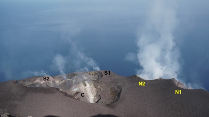
The explosive activity was mainly produced by 3 (three) eruptive vents located in the North crater area and by at least 2 (two) eruptive vents located in the Center-South crater area. All the vents are located inside the depression that occupies the crater terrace.

On September 25, 2022, a lava overflow was observed from the northern area of the crater along the Sciara del Fuoco.
September 25, 2022 lava overflow.
On September 25 from 02:29:24 UTC after intense spattering activity and after a strong explosion at a mouth of the N2 sector of the N crater zone (Fig.3.2 a-b), an overflow of lava began, observable as a rolling of incandescent material and its accumulation along the central and upper part of the Sciara del Fuoco (Fig. 3.2 c-d-e). The effusive event ceased around 06:00 UTC (Fig. 3.2 f).

Observations of explosive activity captured by surveillance cameras:
Sector N1 located in the area of the North crater produced explosions of low intensity (less than 80 m high) to medium (less than 150 m high) emitting coarse materials (bombs and lapilli). Sector N2 showed continuous and sometimes intense spattering activity interrupted by low-intensity explosions emitting coarse material. The average frequency of explosions varied from 3 to 5 events/h.
In the Center-South zone, sectors C and S1 did not show significant explosive activity. Sector S2, with two emission points, showed explosions of mainly medium intensity (less than 150 m) emitting coarse materials sometimes mixed with fines (ash). The frequency of explosions varied between less than 1 and 4 events/h
Source : INGV.
Photos : Stromboli Stati d’Animo
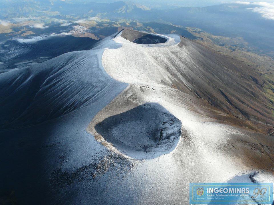
Colombia , Purace / Los Coconucos volcanic chain :
Weekly bulletin of the activity of the Puracé volcano – Los Coconucos volcanic chain
The activity level of the volcano continues at the Yellow Activity Level or (III): changes in the behavior of volcanic activity.
From the analysis and evaluation of the information obtained through the monitoring network of the Puracé volcano – Los Coconucos volcanic chain, during the week of September 20 to 26, 2022, the COLOMBIAN GEOLOGICAL SERVICE – Volcanological and Seismological Observatory of Popayan reports that:
Seismic activity related to rock fracturing again showed a slight increase in the number of events compared to previous weeks. The occurrence of a seismic swarm (high occurrence of seismic events over a short period of time) during September 23 is mainly apparent, this seismicity was located 1 km in a West-South-West direction from the volcano crater Puracé, in a range of depths between 2 and 4 km, with a maximum magnitude of 2.9 ML. Regarding the total number of events recorded during the evaluated period, there were 827 seismic events, of which 322 were associated with rock fracturing processes (type VT) and 505 with fluid dynamics in volcanic conduits; of these, 386 were classified as long-period events (LP type), three (3) were associated with both failure mechanisms and fluid dynamics, for which they were classified as hybrids (HB type ), one (1) was classified as a « tornillo » (type TO), three (3) as low frequency earthquakes (type BF) and 112 as low energy tremor pulses (TR-type).
The geodetic network of GNSS (Global Navigation Satellite System) stations for monitoring ground deformation continues to record a process associated with inflation.
Thanks to the monitoring of surface activity, the images obtained during the week through the web cameras Anambío, Mina, Lavas Rojas, Cerro Sombrero and Curiquinga, have highlighted the degassing of the volcanic system, with a white column oriented preferentially to the northwest.
Regarding volcanic gas monitoring, sulfur dioxide (SO2) flux emissions recorded by telemetric stations continue to show changes in the flux, with a maximum emitted of 1156 t / day for the week assessed. The other instruments for measuring carbon dioxide (CO2) and radon gas (222Rn) in the volcanic influence zone record considerable variations in their concentrations for the period evaluated, which is normal in active volcanic systems.
Magnetic field and infrasound wave monitoring sensors did not record variations associated with changes in volcanic activity.
Source : SGC.
Photo : Ingeominas.
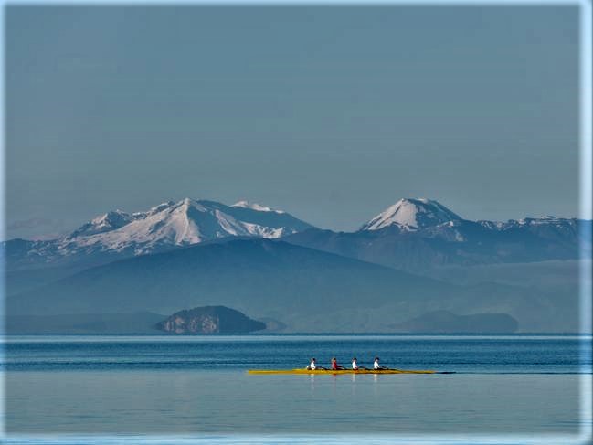
New Zealand , Lake Taupo :
Minor volcanic unrest continues at Taupō Volcano, with ongoing earthquakes and ground deformation. The Volcanic Alert Level for Taupō Volcano remains at 1 (minor volcanic unrest).
The earthquakes and deformation at Lake Taupō have continued this last week. The earthquake activity started to increase above background levels in May 2022 as did the ground deformation. The rate of seismicity has varied during the last 4 months but remains above typical background levels.

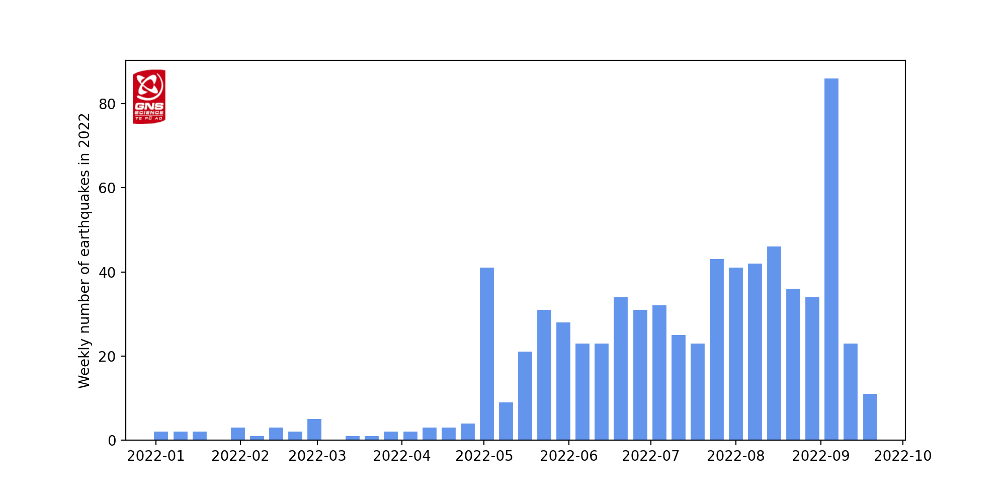
We have reported the ongoing earthquake activity in our last 4 bulletins. The earthquake sequence remains beneath the central part of Lake Taupō and has continued albeit at a slightly lower rate this last week. We have now located approximately 750 earthquakes, mainly at a depth of 4 to 13 km beneath the lake, since the unrest began in May 2022 (see map in Figure 1). The earthquakes in the last week have been concentrated in the eastern part of the lake. Shown in Figure 2 is the number of earthquakes detected per week since early 2022.
In addition to seismic activity, GeoNet continuously monitors ground deformation (land movement) about Lake Taupō. Our GNSS (GPS) instruments around the lake are observing uplift at a rate of 60 ± 20 mm per year since May 2022 at a site on Horomatangi Reef in the lake.
We interpret the ground uplift and earthquake activity to be caused by the movement of magma and the hydrothermal fluids inside the volcano. This activity could continue for the coming weeks or months at varying rates or intensities. While some of the earthquakes may be felt in areas around Lake Taupō, the deformation is currently only detectable by our sensitive ground-based monitoring instruments.
There have been 17 previous episodes of unrest at Taupō over the past 150 years .Several of these were more severe than what we are currently observing at Taupō. None of these episodes, or the many other episodes which would have occurred over the past 1800 years before written records were kept, ended in an eruption. The last eruption at Taupō volcano was in 232 AD ± 10 years. The chance of an eruption at Taupō remains very low in any one year.
Source : Geonet
Photo : Barekiwi
Russia / Kuril Islands , Ebeko :
VOLCANO OBSERVATORY NOTICE FOR AVIATION (VONA)
Issued: September 28 , 2022
Volcano: Ebeko (CAVW #290380)
Current aviation colour code: ORANGE
Previous aviation colour code: orange
Source: KVERT
Notice Number: 2022-125
Volcano Location: N 50 deg 41 min E 156 deg 0 min
Area: Northern Kuriles, Russia
Summit Elevation: 1156 m (3791.68 ft)

Volcanic Activity Summary:
A moderate eruptive activity of the volcano continues. According to visual data by volcanologists from Severo-Kurilsk, explosions sent ash up to 1.9 km a.s.l., an ash cloud is drifting to the east of the volcano; an ashfall is observing at Severo-Kurilsk.
A moderate eruptive activity of the volcano continues. Ash explosions up to 6 km (19,700 ft) a.s.l. could occur at any time. Ongoing activity could affect low-flying aircraft and airport of Severo-Kurilsk.
Volcanic cloud height:
1900 m (6232 ft) AMSL Time and method of ash plume/cloud height determination: 20220928/0045Z – Visual data
Other volcanic cloud information:
Distance of ash plume/cloud of the volcano: 5 km (3 mi)
Direction of drift of ash plume/cloud of the volcano: E / azimuth 80 deg
Time and method of ash plume/cloud determination: 20220928/0045Z – Visual data
Source : Kvert.
Photo : S. Lakomov.
Ecuador , Sangay :
Information, Quito, Tuesday, September 27, 2022
From 01:00 TL, through satellite images (GOES-16), an ash cloud is observed which reaches about 2 km above the crater and is directed towards the South-West. Therefore, there is a possibility of ash fall in the province of Chimborazo. This phenomenon has persisted during the current eruptive period which began in May 2019. IG-EPN continues to monitor the event and will report in a timely manner if changes in seismic signals are detected.
DAILY REPORT OF THE STATE OF SANGAY VOLCANO, Tuesday September 27, 2022.
Information Geophysical Institute – EPN.
Surface Activity Level: High, Surface Trend: No change.
Internal activity level: High, Internal trend: No change.
Seismicity: From September 26, 2022, 11:00 a.m. to September 27, 2022, 11:00 a.m.:
Explosions (EXP) 825
Long Periods (LP) 12
Emission Tremors (TREMI ) 22.
Rains / Lahars:
No rain recorded. **In the event of heavy rains, these could remobilize the accumulated materials, generating mudslides and debris that would descend on the flanks of the volcano and flow into the adjacent rivers.**
Emission / ash column:
In the past 24 hours, the Washington VAAC has issued 3 reports of ash emissions in a west and northwest direction with a maximum height of 2,400 meters above crater level. Frequent small columns of ash were observed during the day.
Other Monitoring Parameters:
The FIRMS system records 34 thermal alerts and MIROVA records 2 high thermal alerts (239 and 196 MW) in the last 24 hours.
Observation:
This morning, according to the images shared by ECU-911, the volcano was clear, an emission of ash could be observed 800 meters above the summit in a southwesterly direction. At the moment, the volcano is cloudy.
Alert level: Orange.
Source : IGEPN.
Photo : Washo Ruiz.