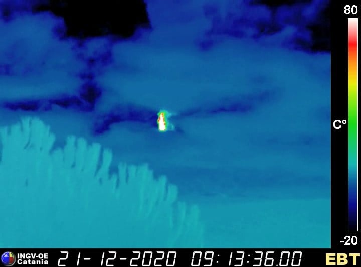
December 21 , 2020.
Italy / Sicily, Etna :
ETNA COMMUNICATION [UPDATE n. 101]
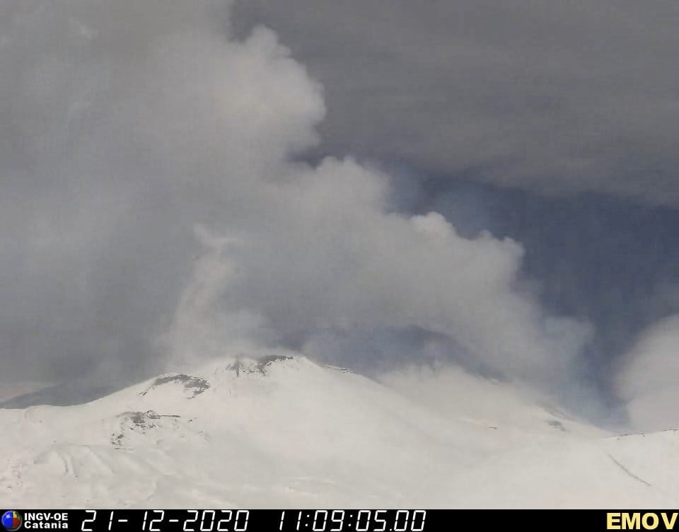
The National Institute of Geophysics and Volcanology, Osservatorio Etneo, announces that following a partial improvement in visibility, from 09:08 UTC, there is a strong intensification of Strombolian activity in the Southeast Crater.
The meteorological conditions do not allow a continuous observation of the phenomenon in progress.
From the seismic point of view, the average amplitude of the volcanic tremor presents high values.
The position of the center of gravity of the sources of earthquakes is located in the area of the Southeast Crater. The infrasound activity is also fairly strong, the events are located at the Southeast Crater.
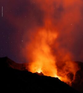
ETNA COMMUNICATION [UPDATE n. 102]
The National Institute of Geophysics and Volcanology, Osservatorio Etneo, announces that from 09:08 UTC the monitoring networks recorded a strong intensification of Strombolian activity in the Southeast Crater. This activity affects at least two of the Southeast Crater mouths at the same time, and it rapidly increased, evolving into a lava fountain a few minutes later.
The activity is still ongoing at the time of this press release, however the weather conditions do not allow continuous observation of the phenomenon taking place through the network of cameras.
Currently, the value of the average amplitude of the volcanic tremor remains at a high level, slightly lower than the maximum reached around 9:20 UTC. The position of the center of gravity of the tremor sources is located in the area of the Southeast Crater.
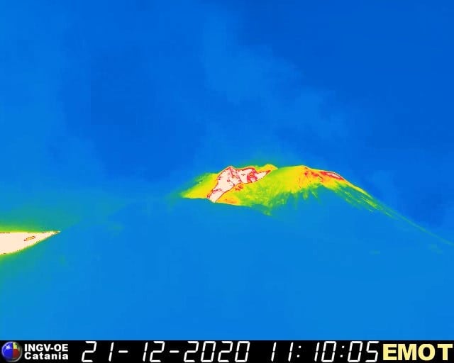
Infrasound activity continues to be sustained, with high values in both frequency of occurrence and amplitude of infrasonic events. The sources of the events are located in the Southeast Crater area.
Ground deformation monitoring networks show clear variations in inclinometric signals from stations at high and medium altitude from around 9:15 a.m.
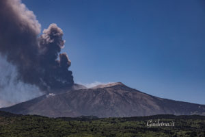
ETNA COMMUNICATION [UPDATE n. 103]
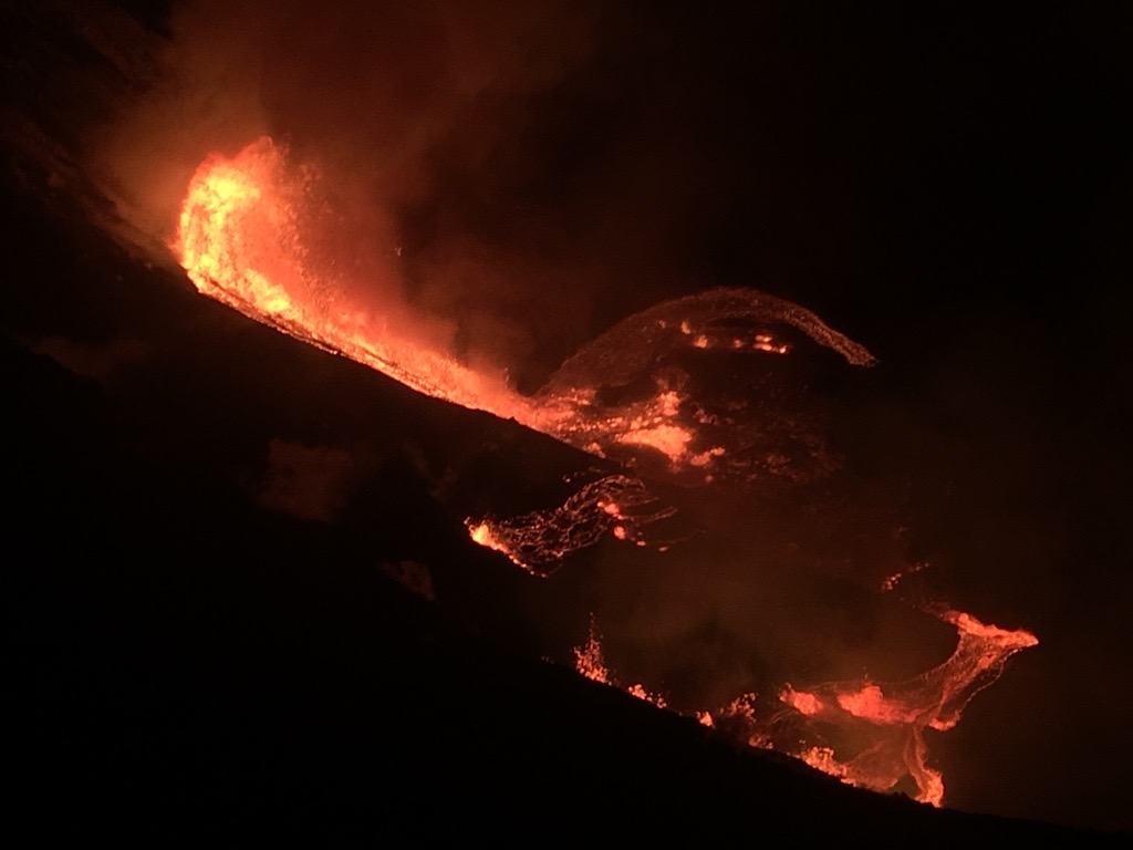
The National Institute of Geophysics and Volcanology, Etneo Observatory, announces that the activity of the lava fountain of the Southeast Crater, reported in the previous press releases (n ° 101 and 102) seems to have been significantly exhausted. At 11:03 UTC, following a very brief improvement in the visibility conditions at the summit, it is possible to observe a lava emission from the landslide zone which opened on the southwest flank of the South West Crater during paroxysmal activity from December 13 in the evening. The lava emission forms a flow towards the West.
The average amplitude of the volcanic tremor showed a sudden and significant decrease. From around 10:30 UTC, the amplitude of the tremor is in the range of average values, showing values always decreasing, now clearly lower than those which characterized the hours preceding the eruptive phenomenon. The position of the center of gravity of the sources of the volcanic tremor remains located in the area of the Southeast Crater.
Finally, infrasound signals also showed the same trend, with a marked decrease in the frequency of occurrence and the amplitude of events. Modest infrasound activity remains in the Southeast Crater region.
The soil deformation monitoring networks show a progressive attenuation of the deformations on the inclinometric signals of the stations at high and medium altitude from around 10:00 a.m. to 10:30 a.m.
Further updates will be communicated shortly.
Source et photos : INGV.
Read the article: http://www.ct.ingv.it/Dati/informative/vulcanico/ComunicatoETNA20201221102111.pdf
Hawaii , Kilauea :
19°25’16 » N 155°17’13 » W,
Summit Elevation 4091 ft (1247 m)
Current Volcano Alert Level: WARNING
Current Aviation Color Code: RED
KĪLAUEA INFORMATION STATEMENT
The U.S. Geological Survey’s Hawaiian Volcano Observatory (HVO) recorded a magnitude-4.4 earthquake located beneath Kīlauea Volcano’s south flank on Sunday, December 20, at 10:36 p.m. HST.
The earthquake was centered about 14 km (8.7 miles) south of Fern Forest, near the Hōlei Pali area of Hawai‘i Volcanoes National Park at a depth of 6 km (4 miles).
Weak to light shaking, with maximum Intensity of IV, has been reported across the Island of Hawai‘i. At that intensity, significant damage to buildings or structures is not expected. The USGS « Did you feel it? » service received over 500 felt reports within the first hour of the earthquake.
An eruption started at Kīlauea summit on December 20 at approximately 9:30 p.m. HST with multiple fissures opening on the walls of Halemaʻumaʻu crater. The lava cascaded into the summit water lake, boiling off the water and forming a new lava lake at the base of the crater. The northern fissure, pictured, was producing the tallest lava fountain at roughly 50 m (165 ft), and all lava was contained within Halemaʻumaʻu crater in Kīlauea caldera.
According to HVO acting Scientist-in-Charge David Phillips, “HVO continues to monitor Kīlauea as the situation is rapidly evolving with this evening’s eruption at the summit of Kīlauea. We will send out further notifications on Kīlauea and other Hawaiian volcanoes as we observe changes.”
Kīlauea’s south flank has been the site of over 30 earthquakes of magnitude-4.0 or greater during the past 20 years. Most are caused by abrupt motion of the volcano’s south flank, which moves to the southeast over the oceanic crust. The location, depth, and waveforms recorded as part of today’s earthquake are consistent with motion along the south flank detachment fault.
DECEMBER 20, 2020
Shortly after approximately 9:30 p.m. HST, the USGS Hawaiian Volcano Observatory (HVO) detected glow within Halemaʻumaʻu crater at the summit of Kīlauea Volcano. An eruption has commenced within Kīlauea’s summit caldera . The situation is rapidly evolving and HVO will issue another statement when more information is available.
.
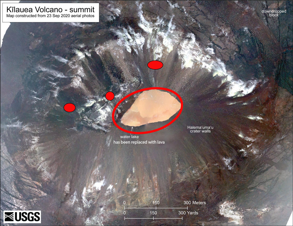
Shortly after approximately 9:30 p.m. HST, an eruption commenced at the summit of Kīlauea Volcano. Red spots are the approximate locations of fissure vents feeding lava flowing into the bottom of Halema‘uma‘u crater. The water lake at the base of Halema‘uma‘u crater has been replaced with a growing lava lake. Lava coverage is deeper by 10 m (32 ft) or larger and bigger in extent than the water in this photo (base map is from imagery collected on September 23, 2020). The easternmost vent is currently exhibiting fountains up to approximately 50 m (164 ft) high with minor fountaining on the west side. Occasion blasts of uncertain origin are occurring from lava lake surface.
An eruption started at Kīlauea summit on December 20 at approximately 9:30 p.m. HST with multiple fissures opening on the walls of Halemaʻumaʻu crater. The lava cascaded into the summit water lake, boiling off the water and forming a new lava lake at the base of the crater. The northern fissure, pictured, was producing the tallest lava fountain at roughly 50 m (165 ft), and all lava was contained within Halemaʻumaʻu crater in Kīlauea caldera.
Source : HVO.
Photos : USGS.