March 02 , 2024.
United States , Yellowstone :
Friday, March 1, 2024, 12:31 PM MST (Friday, March 1, 2024, 19:31 UTC)
44°25’48 » N 110°40’12 » W,
Summit Elevation 9203 ft (2805 m)
Current Volcano Alert Level: NORMAL
Current Aviation Color Code: GREEN
Recent Work and News
Steamboat geyser erupted in the early morning hours of February 26 — its first eruption of 2024.
Seismicity
During February 2024, the University of Utah Seismograph Stations, responsible for the operation and analysis of the Yellowstone Seismic Network, located 125 earthquakes in the Yellowstone National Park region. The largest event of the month was a minor earthquake of magnitude 2.6 located about 9 miles north of Yellowstone Lake in Yellowstone National Park on February 23 at 8:02 PM MST.
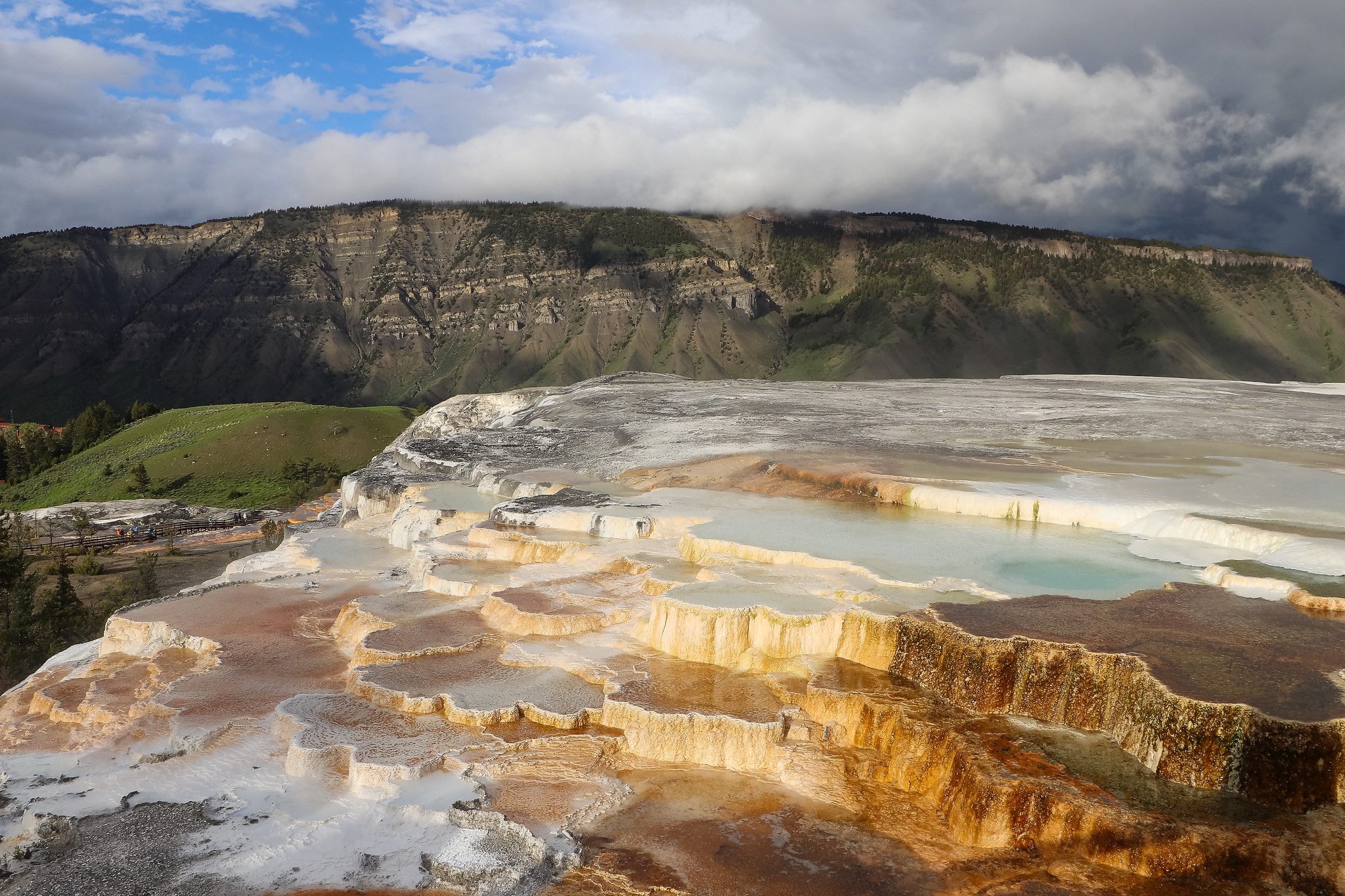
Mammoth Hot Springs and New Blue Spring with Mount Everts in the background.
February seismicity in Yellowstone was marked by two swarms:
1. A swarm of 49 earthquakes, located approximately 15 miles south-southwest of Mammoth, occurred February 18–19. The largest earthquake in the sequence was a magnitude 2.1 on February 18 at 10:05 PM MST.
2. A swarm of 15 earthquakes, approximately 7 miles north of West Yellowstone, MT, occurred February 2–4. The largest earthquake in the sequence was a magnitude 1.3 on February 3 at 5:10 PM MST.
Earthquake sequences like these are common and account for roughly 50% of the total seismicity in the Yellowstone region.
Yellowstone earthquake activity is currently at background levels.
Ground Deformation
During the month of February, continuous GPS stations in Yellowstone caldera showed subsidence, which has been ongoing since 2015, interrupted in summer months by a pause or slight uplift caused by seasonal changes related to snowmelt and groundwater conditions. The caldera has subsided by about 2.5 cm (about 1 in) since the end of September. No significant deformation has occurred at Norris Geyser Basin since the end of summer.
Source : YVO
Photo : YVO/A. Falgoust
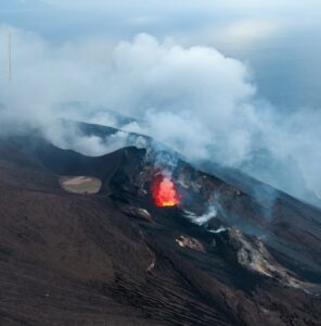
Alaska , Shishaldin :
Low-level unrest continues at Shishaldin Volcano. Seismicity remains slightly elevated and intermittent minor steaming from the summit crater continues. Satellite data show no evidence of elevated surface temperatures or emissions of sulfur dioxide gas, further indicating that unrest remains at a low level. Minor rock falls or collapse events from the unstable ground in and near the summit crater remain likely. These events may generate very small clouds of fine-grained ash that dissipate quickly in the immediate vicinity of the summit.
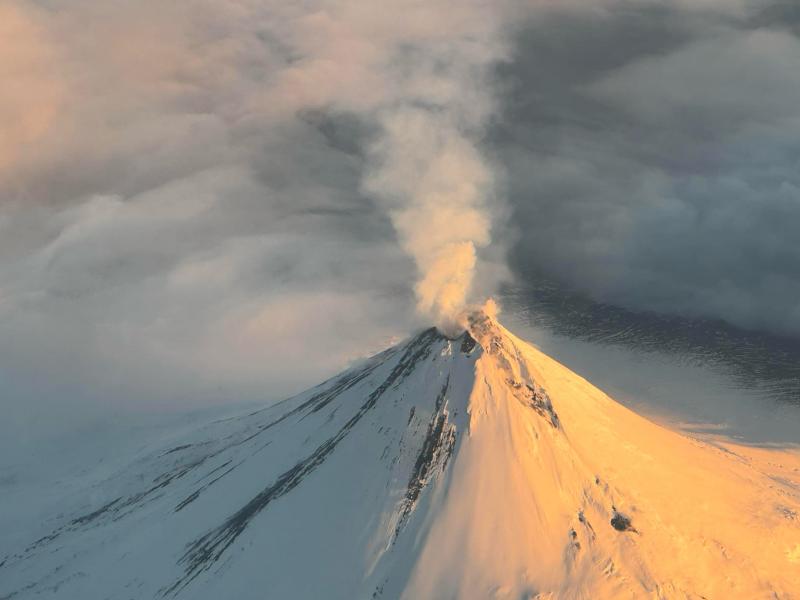
No significant eruptive activity has occurred since November 2023.
Local seismic and infrasound sensors, web cameras, and a geodetic network are used to monitor Shishaldin Volcano. In addition to the local monitoring network, AVO uses nearby geophysical networks, regional infrasound and lighting data, and satellite images to monitor the volcano.
Source : AVO
Photo : Reedy, Brian
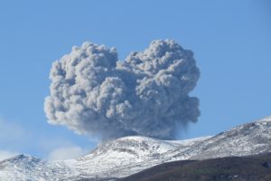
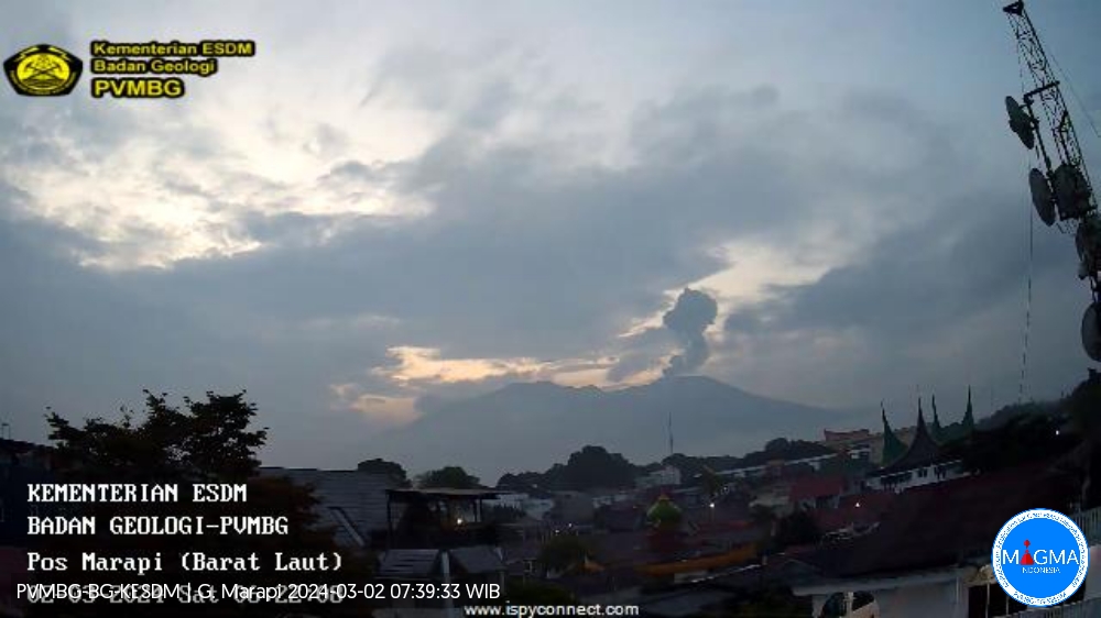
Indonesia , Marapi :
An eruption of Mount Marapi occurred on Saturday, March 2, 2024 at 06:22 WIB with the height of the ash column observed at ± 300 m above the summit (± 3191 m above sea level). The ash column was observed to be gray with thick intensity, oriented towards the West. This eruption was recorded on a seismograph with a maximum amplitude of 4.6 mm and a duration of 49 seconds.
SEISMICITY OBSERVATIONS:
5 eruption/explosion earthquakes with an amplitude of 4.4 to 11.9 mm and an earthquake duration of 35 to 49 seconds.
8 emission earthquakes with an amplitude of 3.1 to 8.5 mm and earthquake duration of 36 to 65 seconds.
1 Low frequency earthquake with an amplitude of 1.5 mm and an earthquake duration of 17 seconds.
3 deep volcanic earthquakes with an amplitude of 3.8 to 10.2 mm, and an earthquake duration of 35 to 49 seconds.
1 Continuous tremor with an amplitude of 0.5 to 2 mm, dominant value of 1 mm.
RECOMMENDATION
1. Communities around Mount Marapi and climbers/visitors/tourists should not enter and conduct activities within a 4.5 km radius of the eruption center (Verbeek crater) of Mount Marapi.
2. Communities living around the valleys/streams/river banks that originate at the summit of Mount Marapi should always be aware of the potential threat of lahars that may occur, particularly during the rainy season.
Source et photo : Magma Indonésie
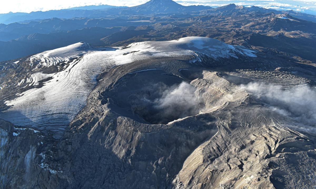
Colombia , Nevado del Ruiz :
Weekly bulletin on the activity of the Nevado del Ruiz volcano
From the monitoring of the activity of the NEVADO DEL RUIZ VOLCANO, the MINISTRY OF MINES AND ENERGY through the COLOMBIAN GEOLOGICAL SERVICE (SGC) reports that:
In the week of February 20 to 27, 2024, the volcano continued with unstable behavior. Compared to the previous week, the main variations in the parameters monitored were:
– Seismicity linked to fluid dynamics inside volcanic conduits has increased both in the number of earthquakes recorded and in seismic energy released. The seismic signals were associated with pulsatile emissions of ash and gas into the atmosphere with energy levels between low and moderate. Thanks to the cameras used to monitor the volcano and reports from SGC Staff or Los Nevados National Natural Park officials in the volcanic area, several ash emissions have been confirmed. There were also some temperature changes related to the emitted material associated with some of the seismic signals. To a lesser extent, low-energy seismicity was recorded associated with the activity of the lava dome (bulge or mound) located at the bottom of the crater.
– Seismic activity associated with the fracturing of rocks inside the volcanic edifice has decreased in the number of earthquakes recorded and in the seismic energy released. The earthquakes were located in the Arenas crater and on the East-Northeast, North-West and South-West flanks of the volcano, up to a maximum distance of approximately 12 km from the crater. The magnitude of the events was less than 1 and their depths varied between less than 1 and 8 km from the summit of the volcano.
– The volcano continued to emit water vapor and gases into the atmosphere. Sulfur dioxide (SO2) outgassing rates were variable and decreased compared to the previous week. The maximum height of the gas or ash column was 1,800 m vertically and 2,000 m dispersed, both values were measured on the volcanic summit on February 27. The direction of dispersion of the column was variable with a tendency towards the northwest and southwest flanks of the volcano.
– In monitoring surface activity, from satellite monitoring platforms, the detection of thermal anomalies at the bottom of Arenas crater continued with low to moderate energy levels.
The alert status for volcanic activity remains at: YELLOW ALERT: ACTIVE VOLCANO WITH CHANGES IN THE BEHAVIOR OF THE BASE LEVEL OF MONITORED PARAMETERS AND OTHER MANIFESTATIONS
Source et photo : SGC
Guatemala , Santiaguito :
Geographical location:
14°44′ 33˝ North latitude;
91°34’13˝ West longitude.
Altitude: 2,500 meters above sea level.
Atmospheric conditions: Clear weather.
Wind: northeast
Precipitation: 0.0 mm.
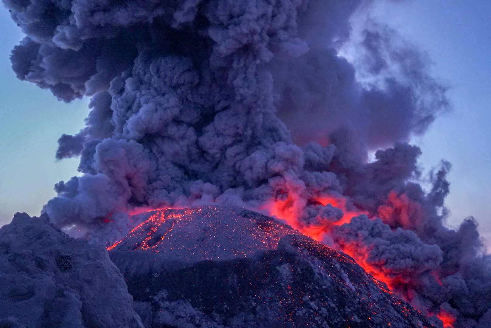
Activity:
The Observatory reports activity in the Caliente dome, with moderate and continuous degassing in the southwest and west directions. There were between 2 to 6 explosions per hour. Moderate and strong explosions raise columns of water vapor and ash to heights of up to 3,400 m (10,498 ft) and cause short-distance pyroclastic flows mainly down the eastern and southern flanks -East. Detachment of boulders from the dome and the edges of the lava flow continues occasionally. Heavy avalanches and audible sounds of volcanic activity are possible. Activity remains at a high level, so there remains the possibility that with explosions or under the effect of gravity, part of the accumulated materials collapse and pyroclastic flows over long distances are generated towards the South. West, South, South-East and East.
Source : Insivumeh.
Photo : Travelsol GT via Shérine France.