October 29 , 2020.
Alaska , Korovin :
AVO/USGS Volcanic Activity Notice
Current Volcano Alert Level: ADVISORY
Current Aviation Color Code: YELLOW
Issued: Wednesday, October 28, 2020, 9:51 AM AKDT
Source: Alaska Volcano Observatory
Location: N 52 deg 22 min W 174 deg 9 min
Elevation: 5030 ft (1533 m)
Area: Aleutians
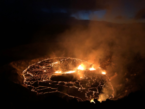
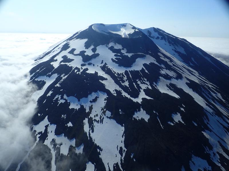
Korovin Volcano’s crater and its lake during helicopter flight to measure gas emissions.
Volcanic Activity Summary:
Based on recent satellite detections of significant sulfur dioxide emissions and an increase in seismicity to a level above background, AVO is raising the Aviation Color Code and Alert Level at Korovin Volcano to YELLOW/ADVISORY. Discrete earthquakes have been detected over the past two weeks and sulfur dioxide degassing has been detected four times in satellite data on October 15, 20 and 26. Clear satellite views show no other signs of activity at this time. AVO will continue to monitor the volcano for signs of volcanic activity.
Korovin is monitored by local seismic and infrasound sensors, satellite data, and regional lightning detection instruments.
Recent Observations:
[Volcanic cloud height] n/a
[Other volcanic cloud information] sulfur dioxide emissions detected in satellite data.
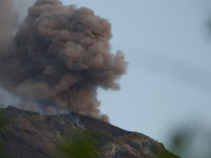
View of Korovin Volcano during a helicopter flight to measure gas emissions. Note the small vapor plume emanating from the crater.
View of Korovin Volcano during a helicopter flight to measure gas emissions. Note the small vapor plume emanating from the crater.
Hazard Analysis:
[General hazards] Seismicity above background levels and sulfur dioxide emissions.
[Volcanic gas] sulfur dioxide emissions detected in satellite data on October 15, 20 and 26.
Remarks:
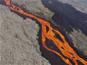
Korovin Volcano is a 1553-m-high (5030 ft) stratovolcano located on the northern part of Atka Island in the central Aleutian Islands, about 21 km (13 mi) northwest of the community of Atka, 538 km (350 mi) west of Dutch Harbor, and 1760 km (1100 mi) southwest of Anchorage. The volcano has two distinct summit vents about 0.6 km (2000 ft) apart, that have been the sites of eruptive activity in historical time. The most recently active of the vents maintains a small, roiling, lake that occasionally produces energetic steam emissions. Thermal springs and fumaroles located on and near the volcano indicate an active hydrothermal system. Korovin has erupted several times in the past 200 years, including 1973, 1987, and 1998, and has likely had small ash emissions as recently as 2005. Typical recent Korovin eruptions produce minor amounts of ash and occasional but small lava flows. Reports of the height of the ash plume produced by the 1998 eruption ranged from 4900 to 10,600 m (16,000 to 35,000 feet) above sea level.
Source : AVO.
Photos : Kelly, Peter .
Kamchatka , Karymsky :
VOLCANO OBSERVATORY NOTICE FOR AVIATION (VONA).
Issued: October 26 , 2020
Volcano: Karymsky (CAVW #300130)
Current aviation colour code: ORANGE
Previous aviation colour code: orange
Source: KVERT
Notice Number: 2020-197
Volcano Location: N 54 deg 2 min E 159 deg 26 min
Area: Kamchatka, Russia
Summit Elevation: 4874.08 ft (1486 m)
Volcanic Activity Summary:
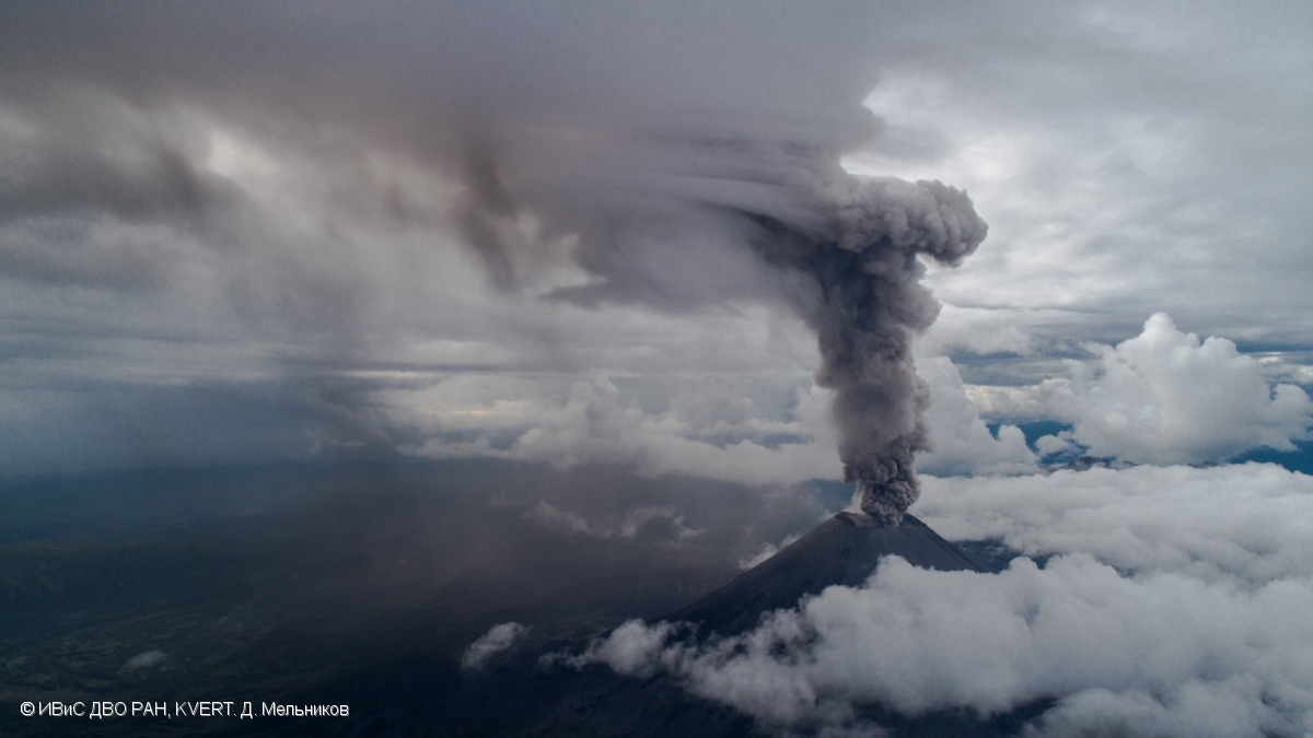
Satellite data by KVERT showed an ash cloud 12×18 km is drifting about 37 km to the north of the volcano.
A moderate eruptive activity of the volcano continues. Ash explosions up to 19,700-23,000 ft (6-7 km) a.s.l. could occur at any time. Ongoing activity could affect low-flying aircrafts.
Volcanic cloud height:
13120-16400 ft (4000-5000 m) AMSL Time and method of ash plume/cloud height determination: 20201026/0450Z – Himawari-8
Other volcanic cloud information:
Distance of ash plume/cloud of the volcano: 23 mi (37 km)
Direction of drift of ash plume/cloud of the volcano: N / azimuth 1 deg
Time and method of ash plume/cloud determination: 20201026/0450Z – Himawari-8
Start time of explosion and how determined: 20201026/0430Z – Satellite data
Source : Kvert .
Photo : D. Melnikov, IVS FEB RAS, KVERT ( 2019) .
Indonesia , Sinabung :
3.17°N, 98.392°E
Elevation 2460 m
PVMBG reported that white plumes rose as high as 500 m above Sinabung’s summit on most days during 20-27 October; foggy conditions sometimes prevented visual observations. On 23 October white-and-gray ash plumes rose as high as 1 km and drifted in multiple directions. Pyroclastic flows traveled 1.5-2.5 km down the E and SE flanks on 25 October. According to a news article ash plumes drifted SE of the volcano twice that same day, causing some local residents to evacuate. The report noted that a lava dome in the summit crater continued to grow. The Alert Level remained at 3 (on a scale of 1-4), with a general exclusion zone of 3 km and extensions to 5 km in the SE sector and 4 km in the NE sector.

There was a hot avalanche cloud over G. Sinabung on October 29, 2020 at 07:52 a.m. WIB. With a sliding distance of 2000 meters to the east-south-east and a height of 1500 meters from the ash column. The wind direction is east to south-east.
The activity level has been at level III (SIAGA) since May 20, 2019 at 10:00 a.m. WIB. The Sinabung volcano (2460 m above sea level) has been erupting since 2013. The last eruption occurred on September 5, 2020, causing a column of gray eruption reaching 800 meters above the summit.
The volcano was clearly visible until it was covered in fog. We observe that the smoke from the crater is white with a thick intensity, from 100 to 300 m above the peak of the crater. Hot avalanche clouds were observed with a slide distance of 1500 m and avalanches with a slide distance of 500 to 700 m to the east and south-east. The weather is sunny, cloudy and rainy, with weak to strong winds in the North-East and South-East. Air temperature 16-24 ° C.

According to the seismographs of October 28, 2020, it was recorded:
1 avalanche of hot clouds
56 avalanche earthquakes
8 emission earthquakes
12 low frequency earthquakes
16 hybrid / multiphase earthquakes
2 local tectonic earthquakes
2 distant tectonic earthquakes
Sources : GVP ,Pvmbg .
Photos : Kodi Setiawan.
Guatemala , Fuego :
SPECIAL VOLCANOLOGICAL BULLETIN
LAHAR IN THE RAVINES LAS LAJAS AND EL JUTE.
At 8:00 p.m. (local time), the descent of weak to moderate lahars is recorded in the Las Lajas and El Jute ravines, tributaries of the Guacalate and Achiguate rivers, respectively, located to the south-east of the volcano.
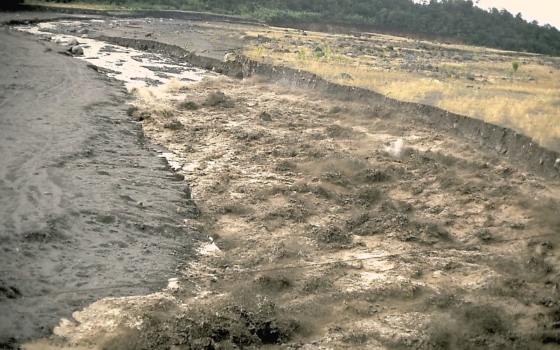
The seismic network of INSIVUMEH located on the Volcán Fuego, records an increase in the amplitude of the seismic signal as shown by the seismogram of the FG12 station. Heavy rains in the upper part of the ravines of the volcanic complex generate the descent of weak to moderate lahars, these can carry tree branches and volcanic material such as ash and boulders 1 to 2 meters in diameter which make the ground vibrate. If the rain persists, the generation of more lahars in these or other ravines of the volcanic complex is not excluded.
Source : Insivumeh .
Photo : USGS Jeff Marso .