July 06 , 2023.
La Réunion , Piton de la Fournaise :
Press release from the Paris Institute of Earth Physics, Piton de la Fournaise Volcanological Observatory. July 05, 2023 – 13:00 – 09:00 UTC.
Ongoing eruption
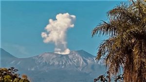
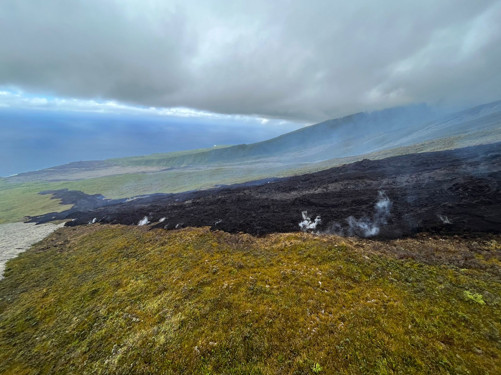
The eruption started on July 02, 2023, around 08:30 local time continues. The amplitude of the volcanic tremor (indicator of an emission of lava and gas on the surface) abruptly dropped yesterday evening at 9:05 p.m. local time (5:05 p.m. UTC) following the occurrence of a localized volcano-tectonic earthquake (M=2.3) directly below the Dolomieu crater.
Lava flow estimates established by satellite method on the HOTVOLC (OPGC – Clermont Auvergne University) and MIROVA (University of Turin) platforms over the past 24 hours indicated flows between 5 and 10 m3 / sec. However, these measurements were reduced by the presence of clouds on the eruptive site for a good part of the day.
The last VIIRS satellite image acquired on July 4, 2023 at 9:18 p.m. UTC (1:18 a.m. local time on July 5) indicated that the thermal anomaly, corresponding to the extension of the flow, had not evolved since yesterday. The images from the webcams this morning do not show any significant progression of the flow front. It was still this morning between 2 and 2.5 km from the RN2.
Last night, the most active parts of the lava flow were located on the upper part of the Grandes Pentes above 1300 m altitude.
For 48 hours, a deflation of the whole building has been recorded. This deflation is linked to the emptying of the magmatic reservoir that feeds the eruption, which is located about 2 km below the summit of Piton de la Fournaise.
The activity at depth is still maintained, even if the number of superficial volcano-tectonic earthquakes over the last 24 hours has further decreased: 36 against 162 the previous 24 hours and against 1059 the still-previous 24 hours. Nevertheless, it is still not excluded that other eruptive cracks will open, especially at lower altitudes, and/or outside the Enclosure.
Increased vigilance is required in the sectors bordering the North and South Enclos . Indeed, given the high probability of the emission of degassed magma, it could be that the OVPF stations located in the sector do not record a volcanic tremor if a crack were to open at low altitude. and/or outside the Enclos .
Alert level: Alert 2-1 (eruption in the Enclos without any particular threat to the safety of people, property or the environment).
Source et photos : OVPF
Iceland , Fagradalsfjall :
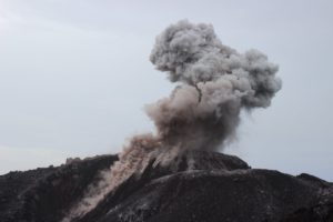
Since the seismic swarm started yesterday, 4 July, over 3000 earthquakes have been detected in the area between Fagradalsfjall and Keilir. The current swarm is characteristic of a new dike intrusion beneath the Fagradalsfjall area, extending to the northeast towards Keilir. The largest earthquake was M4.8 this morning at 8:21. Thirteen earthquakes above M4 have occuured and tens of earthquakes above M3. The largest earthquakes are felt widely in the SW-part of Iceland. Continued seismic activity can be expected tonight.
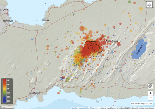
Seismic activity below Fagradalsfjall from 3 p.m. July 4 until 11:30 a.m. July 5. The exact location should be taken with caution as there are still many unlocated earthquakes.
Earthquake activity in Fagradalsfjall area . More than 2200 earthquakes since yesterday
Updated 5. July 2023 at 2:30pm
Earthquake activity commenced around 14:00 UTC yesterday (4 July 2023) beneath the Fagradalsfjall region on the Reykjanes Peninsula, followed by an intense seismic swarm at 16:30 which is still continuing. By noon today ~2200 earthquakes have occurred since the onset of this activity.
The epicentral distribution of the seismicity is narrow and aligned northeast-southwest, between Fagradalsfjall and Keilir.
The seismicity started beneath the known magma upflow region beneath Fagradalsfjall (in the vicinity of the July 2022 dike intrusion) with earthquake depths initially around 8 km, shallowing to approx. 4 km within 5 hours. As of this morning (5 July 2023), seismicity has now reached depths of ~ 2-3 km.
The earthquake magnitudes have also increased during the sequence, with more than seven earthquakes of magnitudes larger than 4 occurring from 7:30 UTC this morning (5 July 2023).
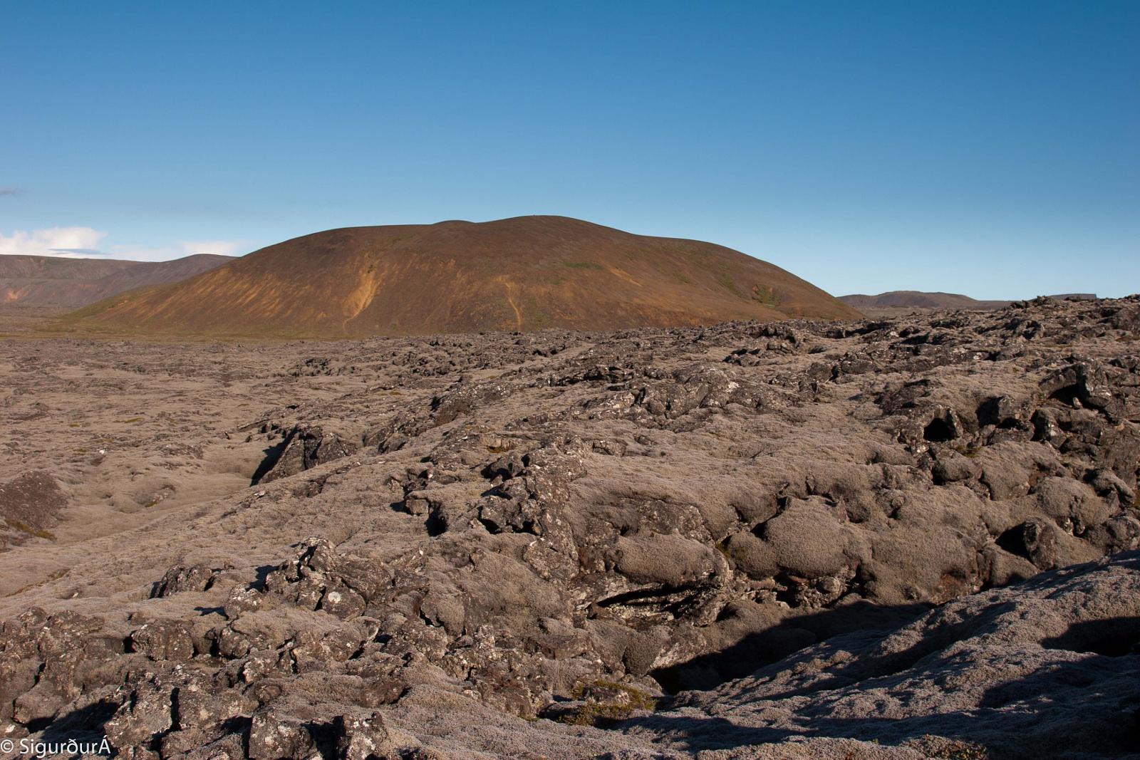
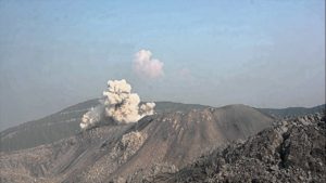
The activity is consistent with the three seismic sequences in 2021 (February-March and December) and 2022 (July-August) that were caused by vertical dike intrusions along the same lineament. Two of these intrusions culminated in an eruption (March 2021 and August 2022).
The current sequence is characteristic of a new dike intrusion beneath the Fagradalsfjall area, extending to the northeast towards Keilir. Specifically, the earthquake activity is similar to what was observed last summer when a dike began propagating in the same area beneath Fagradalsfjall on 30 July 2022 and culminated in an eruption 4 days later (3 August 2022).
The current activity is considered to be heightened unrest with an increased likelihood of an eruption within the coming hours to days.
There is a possibility the activity may cease without an eruption. However, based on current seismicity and similarities with the 2022 dike intrusion the likelihood of an impending eruption is considered high.
The stress changes associated with the intrusion may trigger earthquake activity on nearby faults along the Reykjanes peninsula.
Sources : IMO .
Photos : IMO , Fagradalsfjall , Sthrains
Japan , Kuchinoerabujima :
The number of shallow volcanic earthquakes gradually increased at Kuchinoerabujima, with a total of 100 events recorded during 17-26 June, prompting JMA to raise the Alert Level to 2 (on a scale of 1-5). During late on 26 June until 18h34 on 27 June a total of 50 shallow volcanic earthquakes were recorded, an increased rate of events. At 19h30 JMA raised the Alert Level to 3. Earthquakes continued to be recorded during the rest of the week; there were 41, 18, 9, and 9 events respectively recorded each day during 27-30 June, with most epicenters located near Furudake Crater, and some near Shindake Crater (just N of Furudake).

Sulfur dioxide emissions remained at low levels and no changes were visible to the gas-and-steam emissions which rose as high as 100 m above the crater rim. No obvious changes at the geothermal area near the fissure on the W side of the Shindake were visible during daily field surveys during 28 June-1 July; weather clouds obscured views during 29-30 June. SAR radar data from 30 June revealed inflation within an area extending several hundred meters around the Furudake crater. The public was warned that ejected blocks and pyroclastic flows may impact areas within 2 km of Shindake.
Source : GVP.
Photo : 日本語: 海上保安庁
Peru , Ubinas :
Analysis period: 03-04 July 2023 Arequipa, 05 July 2023.
Alert level: ORANGE
The Geophysical Institute of Peru (IGP) reports that the geophysical processes which make it possible to know the dynamic behavior of the Ubinas volcano (Moquegua region) have made it possible to determine the beginning of the explosive phase, accompanied by ash emissions which have reached up to 5 km above the summit of the volcano. For this, it is suggested to the authorities to maintain the volcanic alert level at the Orange level.
During the analysis period, the occurrence of 69 volcano-tectonic (VT) type earthquakes was detected, associated with rock breaking processes that occur inside the volcano. In addition, 96 long-period (LP) type seismic signals were recorded, associated with the movements of volcanic fluids (gas and magma), with a maximum energy of 0.2 Megajoules. Since 3:16 a.m. on July 4, 16 seismic signals have been recorded associated with explosive activity and consequent ash emissions. For all this, it is possible to indicate the beginning of the magmatic phase of the current eruption.
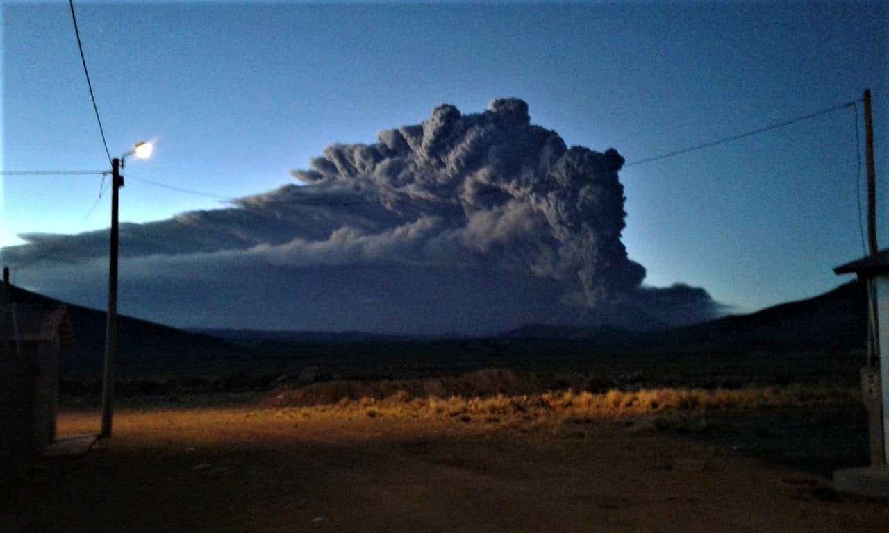
The monitoring of the deformation of the volcanic structure, show variations of less than 5 mm of displacement (within the margin of error of the instruments). Satellite monitoring shows 3 thermal anomalies in the Ubinas crater with a maximum value of 4 MW. Surveillance cameras identified volcanic explosions and columns of gas and ash that reached heights of 5000 m above the summit of the volcano, which were dispersed mainly to the southern, southeastern and East, from the Ubinas volcano with a radius of 20 km (districts of Ubinas, Matalaque, Lloque, Chojata and Yunga). Ash falls have been recorded in the localities of Ubinas, with a thickness of 1 mm.
RECOMMENDATIONS
• Raise the Volcanic Alert Level to ORANGE.
Source : Cenvul
Photo : Radio Melodía AM
Indonesia , Karangetang :
PVMBG reported that daily dense white gas-and-steam plumes from Karangetang were visible rising as high as 400 m and drifting NE, NW, and W during 28 June-4 July. Periodic webcam images published in the reports showed incandescence at Main Crater (S crater) and from material on the flanks of Main Crater; an image from 17h32 on 1 July suggested that a pyroclastic flow descended the SE flank as evident from a linear plume of ash-and-gas rising along its path. Incandescent material extended about 1 km down the S flank and about 600 m down the SSW and SW flanks in a Sentinel satellite image from 2 July. The Alert Level remained at 3 (on a scale of 1-4) and the public were advised to stay 2.5 km away from Main Crater with an extension to 3.5 km on the S and SE flanks.
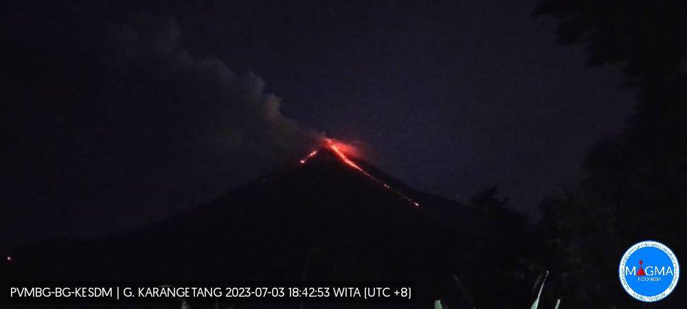
Karangetang (Api Siau) volcano lies at the northern end of the island of Siau, about 125 km NNE of the NE-most point of Sulawesi. The stratovolcano contains five summit craters along a N-S line. It is one of Indonesia’s most active volcanoes, with more than 40 eruptions recorded since 1675 and many additional small eruptions that were not documented (Neumann van Padang, 1951). Twentieth-century eruptions have included frequent explosive activity sometimes accompanied by pyroclastic flows and lahars. Lava dome growth has occurred in the summit craters; collapse of lava flow fronts have produced pyroclastic flows.
Sources : Pusat Vulkanologi dan Mitigasi Bencana Geologi , Sentinel Hub , GVP.
Nicaragua , San Cristobal :
The San Cristóbal volcano, the highest and most active in Nicaragua, recorded an explosion of gas and ash on Wednesday afternoon. The San Cristóbal, 1,745 meters high, is located in the department of Chinandega and is part of the volcanic chain of the Nicaraguan Pacific region. The inhabitants of the community of San Pedro, La Grecia sector, report the fall of ashes. According to SINAPRED, the volcano presented a small explosion of moderate magnitude of gas and ash. He adds that the government maintains monitoring of this volcano and others at the national level.
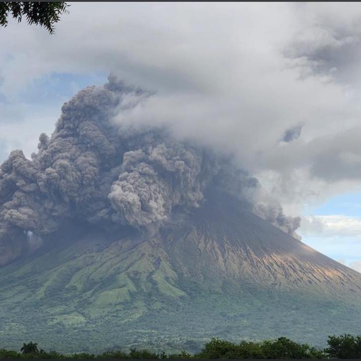
A dense column of gas and ash emanated this Wednesday afternoon from the San Cristobal volcano in the department of Chinandega in western Nicaragua, according to testimonies from social network users through photographs and videos.
So far, the authorities of the National System for Prevention, Mitigation and Attention to Disasters (Sinapred) have not issued any official communication in this regard.
Source : Primerisima Nicaragua via Sherine France.
Photo : Canal 2 Nicaragua