July 21 , 2020.
Iceland , Reykjanes Peninsula :
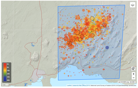
An earthquake swarm in Fagradalsfjall , 20.7.2020
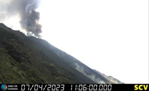
On 19th July at approximately 01:30 a.m. a seismic swarm commenced in Fagradalsfjall. Over 1700 earthquakes have occurred in this region since. The largest event occurred at 23:36 yesterday evening with a magnitude (M) of 5. Two other events greater than M4 occurred early this morning at 05:46 (M4.6) and 06:23 (M4.3), respectively. In addition, 22 earthquakes greater than M3 have occurred since midnight. Felt earthquakes have been reported by local residents as far Akranes in the west and Vík in the east. The seismic swarm is still ongoing with similar intensity.
Fagradalsfjall
Earhquake activity within the Fagradalsfjall area is not uncommon, and seismic swarms have occurred in the past – five significant swarms have occurred here since 1991. However, a swarm of this intensity (both in terms of number of events and magnitude of earthquakes) is not common. The last period of comparable activity was on the 16th September 1973, during which time five earthquakes greater than M4 and one greater than M5 were recorded.
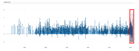
The seismic activity in the vicinity of Fagradalsfjall since 1991, the current activity is the in the red box.
Difficult to interpret the evolution but a few scenarios are possible
The current seismic activity appears to coincide with a series of North-Souh trending tectonic faults. This would indicate these events are of a tectonic nature, but most likely they are the result of stress triggering related to the ongoing magmatic unrest on the Reykjanes Peninsula, which commenced in January this year. Since multiple magmatic instrusions have now occurred beneath the Peninsula since this time, we cannot rule out that the current seismic swarm is the result of an intrusion beneath Fagradalsfjall.
If earthquake activity is related to a magmatic intrusion, then the same hazards would apply as stated previously for Svartsengi/Grindavík, e.g. possibilty of a fissure eruption comprising lava fountaining, lava flows, gas emissions etc.
Possible scenarios:
1) Seismic swarm wanes in the coming days/weeks. Potential for rockslides in the region.
2) Intensity of swarm increases with the occurrence of larger magnitude earthquake – up to M6.0.
3) Magma instrusion occurs in the vicinity Fagradalsjall:
i) Leads to an effusive eruption
ii) Intrusive activity declines and magma body solidifies
The current volcanic unrest in the Reykjanes peninsula keeps changing with time and it is difficult to anticipate its evolution in the future. The origin of this swarm will be verified after the acquisition of new ground deformation data later this week.
Source : Vedur IS.
Photo : Sthrains.
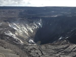
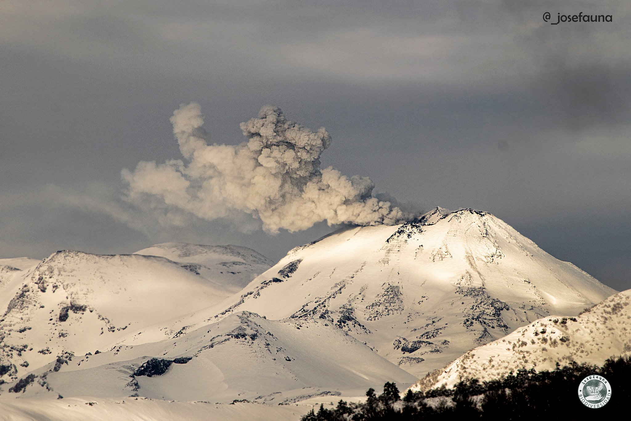
Chile , Nevados de Chillan :
Special Report on Volcanic Activity (REAV) Ñuble Region, Nevados de Chillán Volcanic Complex July 20, 2020, 06:25 Local time (Continental Chile)
The National Geological and Mining Service of Chile (Sernageomin) publishes the following PRELIMINARY information, obtained thanks to the monitoring teams of the National Volcanic Monitoring Network (RNVV), processed and analyzed at the Volcanological Observatory of the Southern Andes (Ovdas):
Yesterday, Monday July 20 at 9:04 p.m. local time (01:04 UTC, July 21, 2020), monitoring stations installed near the Nevados de Chillán volcanic complex recorded an earthquake associated with rock fracturing (Volcano-Tectonics) .
The characteristics of the earthquake after analysis are as follows:
ORIGINAL TIME: 21:04 local time (01:04 UTC)
LATITUDE: 36,853 ° S
LONGITUDE: 71.393 ° W
DEPTH: 3.7 km
LOCAL MAGNITUDE: 3.2 (ML)
OBSERVATIONS:
No surface activity was associated with the reported events. Before the event, 3 volcano-tectonic earthquakes of lesser magnitude were recorded. There have been no reports on the perception of this earthquake.
The volcanic technical alert remains at the Yellow level.
Source : Sernageomin.
Photo : Josefauna.
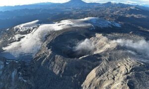
Peru , Sabancaya :
Analysis period: July 13 to 19, 2020, Arequipa, July 20, 2020.
Alert level: ORANGE.
The Geophysical Institute of Peru (IGP) reports that the eruptive activity of the Sabancaya volcano remains at moderate levels; that is to say with the continuous recording of explosions with columns up to 2.4 km high above the summit of the volcano and consequent emissions of ash and gas.
The IGP recorded and analyzed the occurrence of approximately 446 earthquakes of volcanic origin, associated with the circulation of magmatic fluids (magma, gas, etc.) within the Sabancaya volcano (Arequipa region). In addition, an average of 15 low to medium intensity explosions was recorded daily.
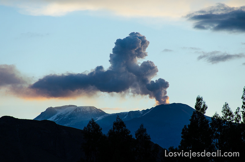
The monitoring of the deformation of the volcanic structure, using GNSS data (processed with fast orbits), does not present any significant anomalies; however, a slight inflation was recorded in the northern sector (Hualca Hualca volcano) and on the south-eastern flank of the Sabancaya volcano. Visual surveillance identified columns of gas and ash up to 2.4 km high at the top of the volcano, which were scattered to the south, southeast, southwest and west of Sabancaya. Satellite monitoring has identified the presence of 12 thermal anomalies with values between 2 MW and 12 MW, associated with the presence of a lava body on the surface of the volcano’s crater.
RECOMMENDATIONS
• Maintain the orange volcanic alert level.
• Do not approach within a radius of less than 12 km from the crater. If ash falls, cover your nose and mouth with wet rags or masks. Keep doors and windows of houses closed.
• Implement prevention and mitigation actions in the face of an increase in volcanic activity.
Source : IGP.
Photo : Losviajesdeali .
Guatemala , Pacaya :
Type of activity: Strombolian.
Morphology: composite stratovolcano
Geographical location: 14 ° 22’50˝ North Latitude; 90 ° 36’00˝ Longitude West
Height: 2552 m.
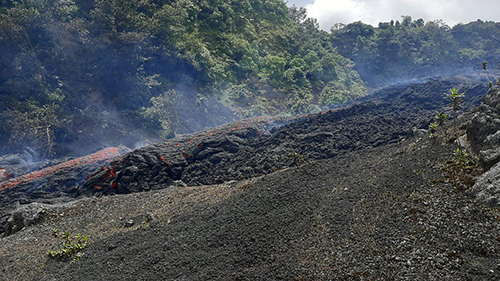
As reported in the special BEPAC 35-2020 and 42-2020 bulletins, the Pacaya volcano is in a high phase of Strombolian activity, which was expressed through the various lava flows and constant explosions in the crater of the Mackenney cone. .
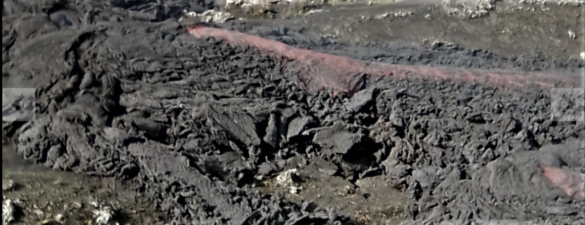
After not having recorded any lava flows between July 14 and 20, a lava flow was again generated this morning, which, unlike those observed recently, does not come from an eruptive focus in the area of the crater but from the north-western base of the cone, in front of Cerro Chino, flowing inside the plateau in a south-eastern direction.
This new lava flow comes after having recorded an increase in the energy released by the volcano (RSAM, measured in number), in recent days, compared to the level it showed a week ago when there was a pause in lava flow emissions, as shown in the figure below.
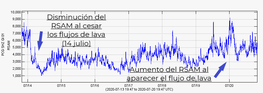
Figure 1. Average seismic amplitude of the PCG station from July 14 to 20, 2020.
This type of activity is not new on the Pacaya volcano, it occurred between 2006 and 2010, in 2014, and more recently in the months of July and August 2019, when the magma rises to the surface by some areas of structural weakness (cracks and fractures) towards the base and surroundings of the volcanic building. Given the high level of activity, the emission of more lava flows around the cone or from the Mackenney crater, with longer ranges and accompanied by moderate and strong explosions, is not excluded.
INSIVUMEH provides visual and instrumental surveillance thanks to the webcam and to the PCG and PCG5 stations, which record the seismic activity generated by the Pacaya volcano.
Source : Insivumeh .
Photos : republica.gt