February 15 , 2024.
Colombia , Nevado del Ruiz :
Weekly bulletin on the activity of the Nevado del Ruiz volcano
From the monitoring of the activity of the NEVADO DEL RUIZ VOLCANO, the MINISTRY OF MINES AND ENERGY through the COLOMBIAN GEOLOGICAL SERVICE (SGC) reports that:
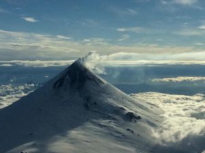
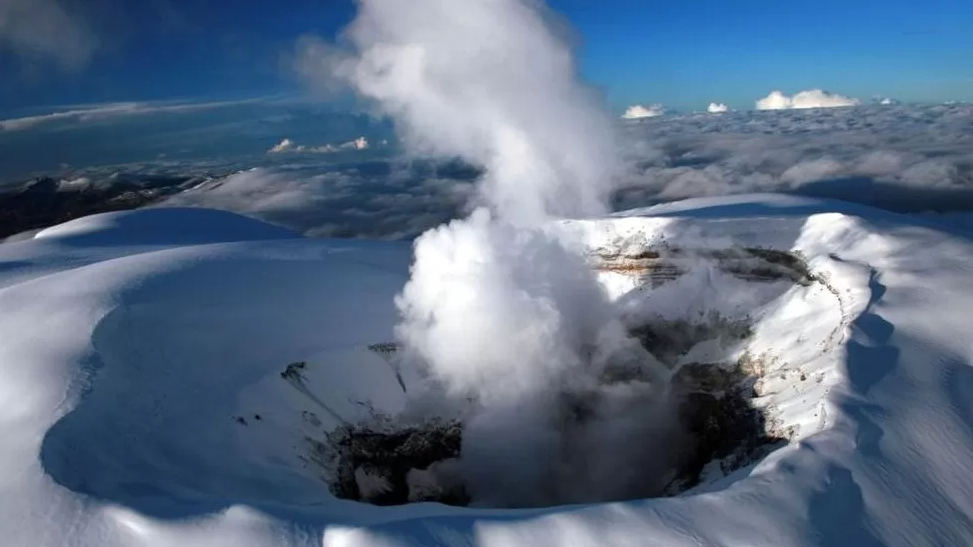
In the week of February 6 to 12, 2024, the volcano continued with unstable behavior. Compared to the previous week, the main variations in the parameters monitored were:
– Seismicity associated with fluid dynamics within volcanic conduits showed similar levels in the number of earthquakes recorded and a decrease in seismic energy released. The seismic signals had low to moderate energy levels and were primarily related to pulsatile emissions of ash and gas into the atmosphere. Using cameras used to monitor the volcano, several ash emissions and changes in relative temperature of the emitted material associated with some of these seismic signals were confirmed.
– Seismic activity associated with the fracturing of rocks inside the volcanic edifice has decreased the number of earthquakes recorded and increased the seismic energy released. The earthquakes were located mainly in the Arenas crater and on the different flanks of the volcano, at distances of up to about 12 km from the crater. The depths of the events varied between 1 and 8 km from the summit of the volcano. The highest magnitude of the week was 1.6 corresponding to the earthquake of February 7 at 10:36 a.m., located approximately 7 km east of the crater, 3 km deep.
– The volcano continued to emit water vapor and gases into the atmosphere. Sulfur dioxide (SO2) outgassing rates were variable and continued with low values similar to those recorded the previous week. The vertical height of the gas or ash column maintained values below 1,000 m and in dispersion it reached 2,000 m (measured above the summit of the volcano) on February 11. The direction of dispersion of the column was variable towards the different flanks of the volcano.
– When monitoring surface activity, from satellite monitoring platforms, several thermal anomalies were detected at the bottom of Arenas crater with energy levels varying between low and moderate.
Servicio Geológico Colombiano’s (SGC) Observatorio Vulcanológico y Sismológico de Manizales reported that unstable eruptive activity at Nevado del Ruiz continued during 30 January–6 February. Seismic events indicating rock fracturing remained similar to the previous week in both number of events and seismic energy released. These events were mainly located in areas up to 5 km to the NE, SE, S, and SW of Arenas Crater, and at depths of 1-7 km. The largest event, a M 1.1, occurred at 0648 on 2 February and was located about 2 km SSE of the crater and at a depth of 4 km. Seismicity associated with gas-and-ash emissions remained at similar numbers as the previous week but were more intense, and several ash emissions were observed through cameras. On 5 February an ash plume rose to a maximum height of 1.8 km above the summit. Sulfur dioxide emissions varied but continued at a low level overall. The Alert Level remained at Yellow, Level III (the second level on a four-level scale), and the public was warned to stay out of the restricted areas around Arenas Crater.
Sources : SGC , GVP
Photos : SGC
Indonesia , Ibu :
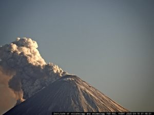
An eruption of Mount Ibu occurred on Wednesday, February 14, 2024 at 8:45 p.m. WIT with the height of the ash column observed at ±800 m above the summit (±2,125 m above sea level). The ash column was observed to be gray with thick intensity, oriented towards the South-West and West. This eruption was recorded on a seismograph with a maximum amplitude of 28 mm and a duration of 67 seconds.
SEISMICITY OBSERVATIONS:
23 explosion/eruption earthquakes with an amplitude of 15 to 28 mm and a duration of 22 to 161 seconds.
146 emission earthquakes with an amplitude of 2 to 14 mm and duration of 15 to 50 seconds.
107 Shallow volcanic earthquakes with an amplitude of 2 to 14 mm and an earthquake duration of 4 to 14 seconds.
5 deep volcanic earthquakes with an amplitude of 11 to 28 mm, and a duration of 4 to 12 seconds.
6 distant tectonic earthquakes with an amplitude of 3 to 10 mm, and the duration of the earthquake was 38 to 92 seconds.
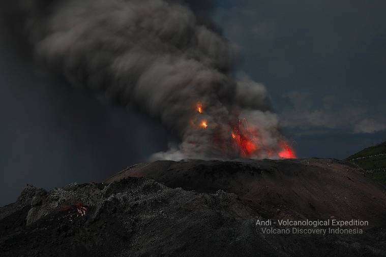
PVMBG reported that Ibu continued to erupt during 7-13 February. White and gray emissions rose 200-1500 m above the summit daily. Eruptive events were detected by a seismograph on 8 and 10 February. Dense, gray ash emissions rose as high as 1.5 km above the summit and drifted E, SW, and W. Eruption column heights were not observed during 12 February. The Alert Level remained at 2 (the second highest level on a four-level scale), with the public advised to stay outside of the 2 km radius hazard zone and 3.5 km away from the N area of the active crater.
Source : Magma Indonésie , GVP.
Photo : Andi Rosati / Volcanodiscovery ( archive).
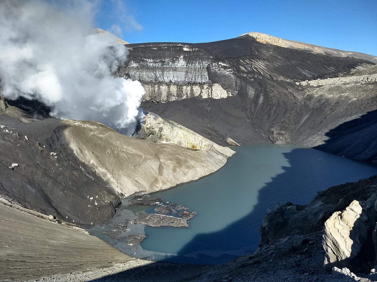
Chile , Copahue :
Seismology
The seismological activity of the period was characterized by the recording of:
20 seismic events of type VT, associated with the fracturing of rocks (Volcano-Tectonics). The most energetic earthquake had a Local Magnitude (ML) value equal to 0.6, located 7.3 km west-northwest of the volcanic edifice, at a depth of 6.5 km relative to to the crater.
Fluid geochemistry
The sulfur dioxide (SO2) emissions data obtained by the differential optical absorption spectroscopy (DOAS) equipment, corresponding to the Mellizas station, installed 6 km east-northeast of the active crater, presented an average value of 392 ± 83 t/d, with a maximum value of 821 t/d, on January 3. Depending on the activity of the volcano, these values remain at levels considered low.
No anomalies have been reported in emissions of sulfur dioxide (SO2) into the atmosphere in the area near the volcano, according to data published by the Tropospheric Monitoring Instrument (TROPOMI) and Sulfur Dioxide Group of the Ozone Monitoring Instrument (OMI).
During the period, no thermal alert was recorded in the area associated with the volcanic edifice, according to data processed by the Middle Infrared Observation of Volcanic Activity (MIROVA). In addition, no radiance anomalies were reported thanks to the analytical processing of Sentinel 2-L2A satellite images, in combination of false color bands.
Geodesy
Geodetic activity was characterized by:
– Deformation rates of medium magnitude, which do not exceed 0.5 cm/month in its horizontal components and 0.9 cm/month in its vertical components, with specific changes in the signal associated with the appearance of occasional interruptions in the data register.
– Changes to the monitoring line of small magnitude, associated with the changes already described and not linked to volcanic activity.
In conclusion, there is no change suggesting deformation of the volcanic system.
Activity remained at levels considered low, suggesting stability of the volcanic system. The technical volcanic alert is maintained in:
GREEN TECHNICAL ALERT: Active volcano with stable behavior – There is no immediate risk
Source : Sernageomin
Photo : Carpediem1971
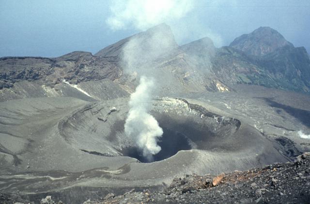
Japan , Suwanosejima :
JMA reported that the eruption at Suwanosejima’s Ontake Crater continued during 5-12 February. Crater incandescence was observed in thermal webcam images. A total of two eruptions were reported; large volcanic blocks were ejected as far as 500 m away from the vent. The eruptions recorded at 1147 on 6 February and 1314 on 12 February produced ash plumes that rose 1 km above the crater rim before drifting SE and S, respectively. Seismicity consisted of a few volcanic earthquakes detected in the W area of the island, and episodes of tremor that occurred at the same time as the eruptive events. The Alert Level remained at 2 (on a 5-level scale), and the public was warned to stay at least 1 km away from Ontake crater in all directions.
The 8-km-long island of Suwanosejima in the northern Ryukyu Islands consists of an andesitic stratovolcano with two historically active summit craters. The summit is truncated by a large breached crater extending to the sea on the east flank that was formed by edifice collapse. One of Japan’s most frequently active volcanoes, it was in a state of intermittent Strombolian activity from Otake, the NE summit crater, between 1949 and 1996, after which periods of inactivity lengthened. The largest recorded eruption took place in 1813-14, when thick scoria deposits blanketed residential areas, and the SW crater produced two lava flows that reached the western coast. At the end of the eruption the summit of Otake collapsed, forming a large debris avalanche and creating the open Sakuchi caldera, which extends to the eastern coast. The island remained uninhabited for about 70 years after the 1813-1814 eruption. Lava flows reached the eastern coast of the island in 1884. Only about 50 people live on the island.
Source : GVP
Photo : Yukio Hayakawa, 1998 (Gunma University).
Hawaii , Kilauea :
Wednesday, February 14, 2024, 9:15 AM HST (Wednesday, February 14, 2024, 19:15 UTC)
19°25’16 » N 155°17’13 » W,
Summit Elevation 4091 ft (1247 m)
Current Volcano Alert Level: ADVISORY
Current Aviation Color Code: YELLOW
Activity Summary:
Kīlauea volcano is not erupting. Seismicity at the summit and along the Koaʻe fault system southwest of the summit continues following an intrusion of magma into the area at the end of January.
Summit Observations:
Seismicity beneath the summit and extending 5-7 miles (8-11 km) southwest of the caldera under the Koaʻe fault zone continues. Earthquakes are dispersed widely from the summit to the southwest and counts remain below 10 earthquakes per hour. There were approximately 32 earthquakes recorded across this region over the past 24 hours. Depths remain consistent at 1–5 km (0.6-3 mi) below the surface, and magnitudes are typically below M2.0.
Ground deformation remains low with tiltmeters near Sand Hill and Uēkahuna bluff recording little change (less than 2 microradians of inflationary signal) in the past 24 hours.
Sulfur dioxide (SO2) gas emission rates have remained low since October 2023. An SO2 emission rate of approximately 70 tonnes per day was recorded on January 17.
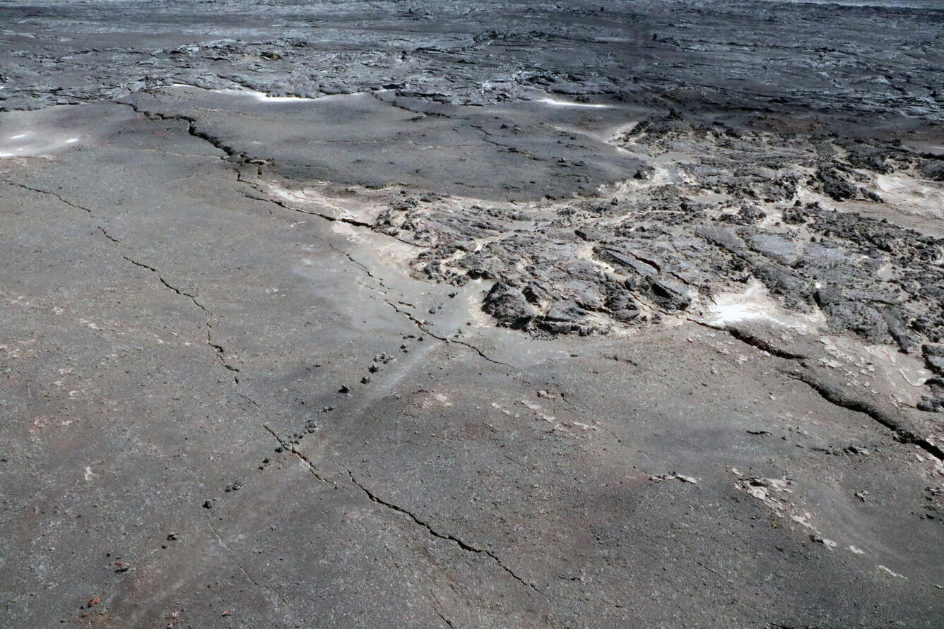
This aerial photo shows some of the new cracks that developed as a result of the recent intrusion southwest of Kīlauea’s summit. HVO geologist who hiked out to this region of the Maunaiki trail (marked by the line of rocks in the photo) in Hawai‘i Volcanoes National Park noted that the cracks extended tens of meters in length and centimeters (inches) in width in the vicinity of Twin Pit Craters in the Ka‘ū Desert.
Rift Zone Observations:
Seismicity in Kīlauea’s upper East Rift Zone and Southwest Rift Zone remain low. No unusual activity has been noted along the middle and lower sections of Kīlauea’s East Rift Zone. We continue to closely monitor both rift zones.
Source : HVO
Photo : USGS/ K. Mulliken.