May 29 , 2020.
Kamchatka , Klyuchevskoy :
VOLCANO OBSERVATORY NOTICE FOR AVIATION (VONA).
Issued: May 29 , 2020 .
Volcano: Klyuchevskoy (CAVW #300260)
Current aviation colour code: ORANGE
Previous aviation colour code: orange
Source: KVERT
Notice Number: 2020-104
Volcano Location: N 56 deg 3 min E 160 deg 38 min
Area: Kamchatka, Russia
Summit Elevation: 15580 ft (4750 m)
Volcanic Activity Summary:
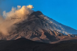
A moderate explosive-effusive eruption of the volcano continues. The Strombolian volcanic activity is observing. The lava flow continues to move on the southeastern flank of the volcano (the Apakhonchich chute), phreatic bursts accompany this process. According to satellite and visual data, a weak ash plume is extending for 400 km to the south-east of the volcano.
This activity continues. Ash explosions up to 16,400-23,000 ft (5-7 km) a.s.l. could occur at any time. Ongoing activity could affect low-flying aircraft.
Volcanic cloud height:
18040-19680 ft (5500-6000 m) AMSL Time and method of ash plume/cloud height determination: 20200529/0510Z – Himawari-8
Other volcanic cloud information:
Distance of ash plume/cloud of the volcano: 249 mi (400 km)
Direction of drift of ash plume/cloud of the volcano: ESE / azimuth 109 deg
Time and method of ash plume/cloud determination: 20200529/0510Z – Himawari-8
Source : Kvert .
Photo : Andrew Matseevsky / Kamchatka – Land of Colors / VolcanoDiscovery.
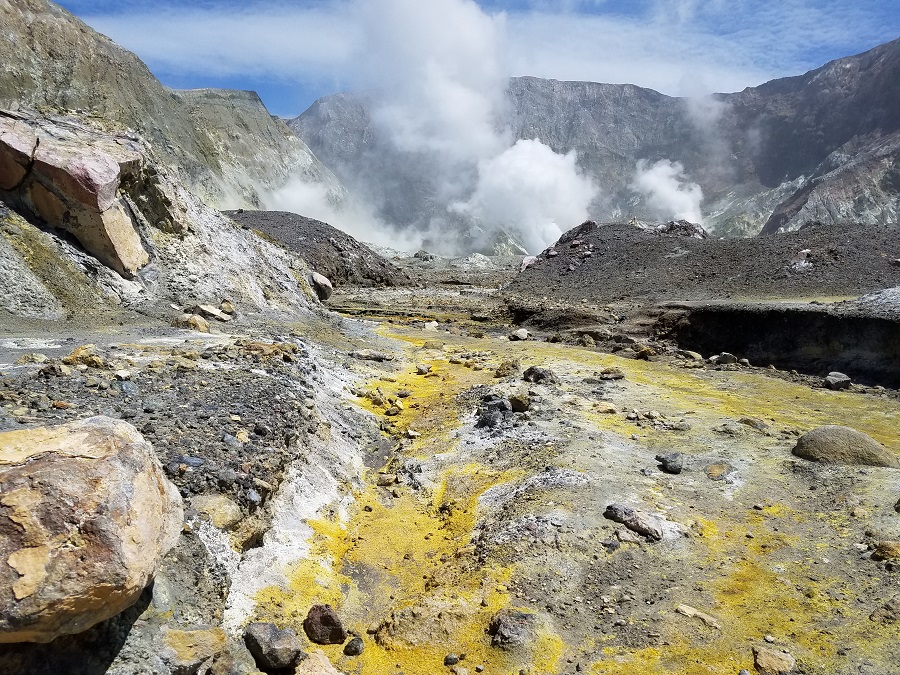
New Zealand ,White Island :
Whakaari/White Island: Monitoring and activity update
Published: Fri May 29 2020 3:00 PM
Volcanic Alert BulletinWI – 2020/08
Volcanic Alert Level remains at 2
Aviation Colour Code remains at Yellow
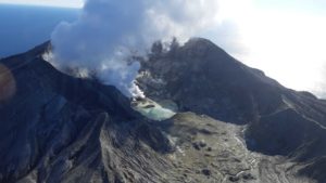
Whakaari/White Island remains in an elevated state of volcanic unrest. Gas flux has varied above background levels, and was elevated in our latest observation flight. Other monitoring parameters mostly remain within the range observed over the last 2 months. The Volcanic Alert Level remains at Level 2; Aviation Colour Code remains at Yellow.
GNS Science volcanologists have recently reinstated gas and observation flights over Whakaari/White Island for the first time since COVID-19 restrictions were put into place.
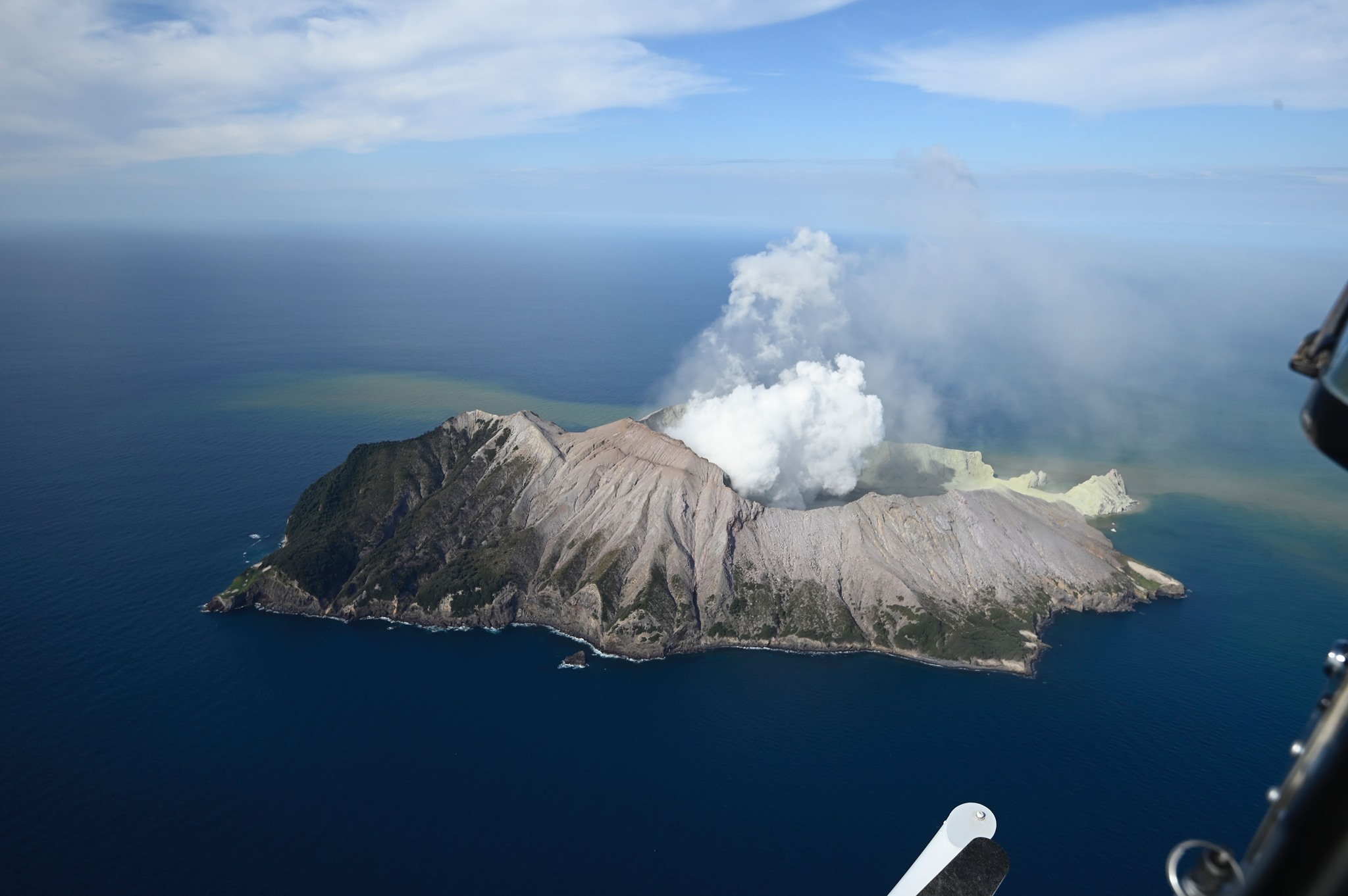
Results from the most recent gas flight on Wednesday 27 May indicate an increased gas flux since the previous flight on 20 May. While previous observations indicated a trend back to levels that are typical for this volcano, the recent increase in SO2 and CO2 gas flux, one of our main indicators of volcanic unrest, could be attributed to a new batch of the magma beneath the volcano at shallow depth. Thermal infrared images, taken during the observation flight on Wednesday 20 May, show that the lava extrusions, first detected in early January, are still very hot, at around 500 °C. Hot gases that are being emitted around these lava lobes generate a ‘night glow’ that can be seen on GeoNet’s night-vision webcams.
We are still observing occasional episodes of slightly elevated tremor, albeit overall tremor levels remain low and within background levels for the volcano. This week we have recorded some shallow source volcanic earthquakes. Satellite based measurements of ground deformation show the ground about the active vent area has subsided by several centimetres since the December 2019 eruption.
Our recent observations are consistent with a volcanic system that is still very dynamic, despite several monitoring parameters trending back towards pre-eruption levels. An eruption could occur with little precursory activity. Plausible triggers for an eruption remain the collapse of unstable material around the vents, sudden release of gas from the magma, and the rapid ingress of water onto the shallow magma body.
Should any explosive activity produce an ash cloud, the likelihood of ash affecting the mainland remains very low. Under suitable weather conditions, the gas and steam plume may be noticed on the mainland as weak acid rain.
The Volcanic Alert Level remains at Level 2.
The Aviation Colour Code remains at Yellow.
Volcanic Alert Level 2 indicates moderate-to-heightened unrest with potential for eruption hazards, including unpredictable and life-threatening steam driven eruptions.
The Volcanic Alert Level reflects the current level of volcanic activity and is not a forecast of future activity. GNS Science and our National Geohazards Monitoring Centre continue to closely monitor Whakaari/White Island for further signs of activity. Further updates will be provided as needed.
Source : Geonet / Yannik Behr / Duty Volcanologist.
Photos : The Next California Earthquake , Weatherboy .
Hawaii , Mauna Loa :
19°28’30 » N 155°36’29 » W,
Summit Elevation 13681 ft (4170 m)
Current Volcano Alert Level: ADVISORY
Current Aviation Color Code: YELLOW
Activity Summary:
Mauna Loa Volcano is not erupting. Rates of deformation and seismicity have not changed significantly over the past week and remain above long-term background levels.
Observations:
During the past week, HVO seismometers recorded 120 small-magnitude earthquakes on the volcano’s summit and upper-elevation flanks. Most of these earthquakes occurred at shallow depths of less than 8 kilometers (~5 miles) below sea level. The largest earthquake was a magnitude-3 (M3) event that occurred below the volcano’s western flank on May 24.

Global Positioning System (GPS) measurements show long-term slowly increasing summit inflation, consistent with magma supply to the volcano’s shallow storage system.
Gas concentrations at the Sulphur Cone monitoring site on the Southwest Rift Zone remain stable. Fumarole temperatures as measured at both Sulphur Cone and the summit have not changed significantly.
Source : HVO.
Costa Rica , Turrialba / Poas / Rincon de la Vieja :
Weekly bulletin from the volcanic monitoring program May 25, 2020.
Turrialba volcano:
Lat: 10.025 ° N; Long: 83,767 ° W;
Height: 3340 m above sea level
Current activity level: 2 (active volcano)
Potentially associated hazards: gas, ash emission, Proximal ballistic projections.
No ash emission was detected. Seismicity remains stable. The tendency to contract and collapse of the Turrialba-Irazú massif remains and is significant, centered towards Irazú. The CO 2 / SO 2 and H 2 S / SO 2 gas ratios remain in their normal ranges for this period despite the limited data due to bad weather conditions. The flow of SO 2 remains stable.
Poas Volcano:
Lat: 10.2 ° N; Long: 84.233 ° W;
Height: 2780 m above sea level
Current activity level: 2 (active volcano) Potentially associated hazards: gas, eruptions of groundwater, Proximal ballistic projections.
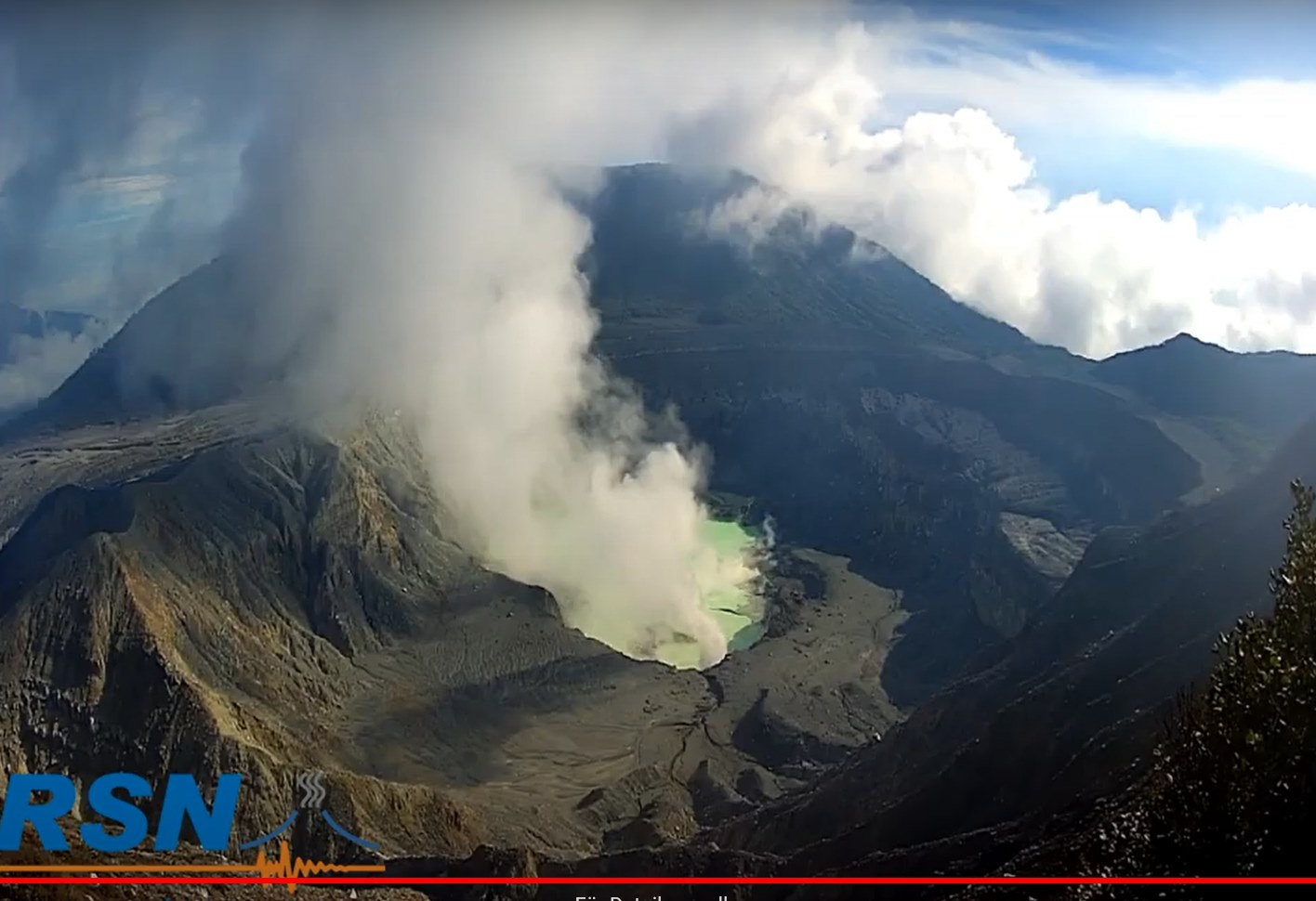
No eruption was detected. A fragmented tremort, very short and periodic is observed. Seismic activity is unstable. Short tremors associated with deeper processes are recorded compared to last month. Deformation monitoring shows stability with a slight tendency to extend. The gas ratios remain stable, a slight increase in H 2 S is observed. The flow of SO 2 is generally stable in the range of 100 to 150 tonnes / day. Due to heavy rain last week, the lake level rose from 20 to 30 cm.
Rincon de la Vieja volcano:
Lat: 10.83 ° N; Long: 85.324 ° W;
Height: 1895 m above sea level
Current activity level: 3 (erupting volcano) Potentially associated hazards: gas, phreatic eruptions, Proximal ballistic projections, lahars.
https://www.facebook.com/OVSICORI/videos/269472371126273/
The activity of the volcano was maintained with few eruptions (seismic signals and infrasound) and many exhalations (only infrasound signal) which give off a fairly constant energy. In general, there is no noticeable increase in activity. A decrease in the amplitude of the signals is observed, which compensates for the increase in the frequency of occurrence of the events. In addition, a decrease in the number of volcano-tectonic (VT) type events is observed. As of May 22, a change has been observed with a decrease in the number of short tremors, a decrease in the frequency of occurrence of exhalations. This could be explained by a lower capacity of the volcano to accumulate pressure, by having a more open duct. The eruptions were not large enough to generate lahars. The geodetic measurements show a tendency to deflation and contraction in May, but it is not yet significant. An overview for photogrammetric measurements was carried out, which still showed the existence of a large lake which had dropped by ~ 5 m since February. Some ballistic impacts have been identified during recent eruptions.
Source : Ovsicori .
Photos : Jean Paul Calvo, RSN .
Video : Ovsicori .