February 16 , 2020 .
La Réunion , Piton de la Fournaise :
Activity bulletin for Saturday 15 February at 3.30 p.m. (local time).
A rapid fall in the volcanic tremor was recorded from 2 p.m. local time (Figure 1). However, since 2:20 pm we continue to record a residual volcanic tremor at the 2 seismic stations closest to the eruptive site.
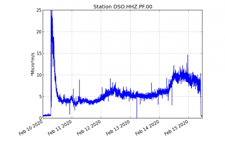
Figure 1: Evolution of the RSAM (indicator of the volcanic tremor and the intensity of the eruption) between 02/10/2020 and 02/15/2020 3.30 p.m. local time (11.30 a.m. UT) on the DSO seismological station located at the top of the volcano. (© OVPF / IPGP)
Given the adverse weather conditions on site, no visual observation could be made. Consequently, at the present time it is impossible to confirm or not to stop the eruptive activity of Piton de la Fournaise (Figure 2).
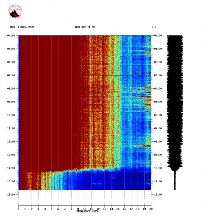
Figure 2: Spectrogram showing the evolution of the spectrum of the seismic signal (indicator of the volcanic tremor and the intensity of the eruption) between 02/10/2020 and 02/15/2020 3.30 p.m. local time (11.30 a.m. UT) on the DSO seismological station located at the top of the volcano. (© OVPF / IPGP).
Alert level: 2-2
Fall in activity at the volcano, towards the end of an eruption?
A rapid fall in the volcanic tremor was recorded from 2 p.m. this Saturday, February 15, 2020 by the teams of the Observatory. « However, since 2:20 pm we have continued to record a residual volcanic tremor at the 2 seismic stations closest to the eruptive site. Given the unfavorable weather conditions on site, no visual observation could be made. « At present it is impossible to confirm or not the cessation of the eruptive activity of Piton de la Fournaise » adds the OVPF.
« As long as there is no visual feedback, we cannot declare the end of the eruption, » said Aline Peltier, director of the OVPF. « The weather conditions are not good enough, impossible to go check at the moment. » The observatory teams hope at least to be able to get there by Sunday 16 February.
Regarding the activity, « the recording of a residual tremor on two stations suggests that there are still small things coming out. It can be simply gases, or flows that continue, or small projections » adds the director of the observatory.
The fall observed remains brutal, however. « One out of two eruptions ends up like this, in a very brutal way » notes Aline Peltier. « In the morning it was stable, fairly continuous and the activity dropped suddenly.
Activity bulletin for Sunday February 16 at 8:30 am (local time).
Aerial observations this morning by the pilots of the helicopter companies report that no more surface activity was visible around 7:30 am to 8:00 am local time on the eruptive site.
However, a residual tremor, the intensity of which has increased since around 4:40 local time, is still recorded at the seismological stations closest to the eruption, as well as degassing, meaning that there is still magma close to the surface at the level of the eruptive site. Thus, no hypothesis is ruled out as to the evolution of the situation to come (final cessation, resumption of surface activity on the same site, resumption of activity on another site).
Source : OVPF. ipreunion.com
Read the articles : http://www.ipgp.fr/fr/ovpf/bulletin-dactivite-samedi-15-fevrier-a-15h30-heure-locale
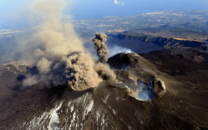
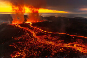
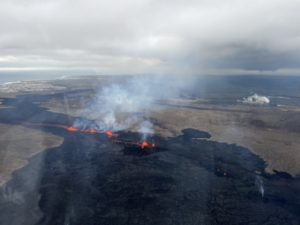
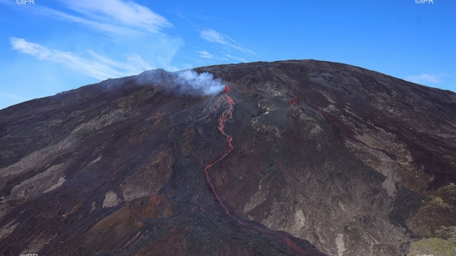
Photo : RB Imazpressréunion
Alaska , Semisopochnoi :
AVO/USGS Volcanic Activity Notice
Current Volcano Alert Level: WATCH
Previous Volcano Alert Level: ADVISORY
Current Aviation Color Code: ORANGE
Previous Aviation Color Code: YELLOW
Issued: Saturday, February 15, 2020, 12:19 AM AKST
Source: Alaska Volcano Observatory
Location: N 51 deg 55 min E 179 deg 35 min
Elevation: 2625 ft (800 m)
Area: Aleutians
Volcanic Activity Summary:
A series of small explosions and tremor bursts have been detected in seismic data at Semisopochnoi over the past 7 hours and are continuing, representing a significant uptick in activity. No ash plumes have been observed, however low-level ash emissions may accompany these minor explosions. Any ash emissions may be currently obscured by cloud cover at ~10,000 ft. The Alaska Volcano Observatory is therefore raising the Aviation Color Code to ORANGE and the Alert Level to WATCH.
Current activity consists of tremor bursts lasting from three to twelve minutes every few hours. No ash plumes have been observed, however low-level ash emissions may accompany these minor explosions. Any ash emissions may be obscured by persistent cloud cover at the volcano between 5,000 and 15,000 ft.
Recent Observations:
[Volcanic cloud height] No cloud observed
[Other volcanic cloud information] No cloud observed
Remarks:
Semisopochnoi is monitored with an on-island seismic network, and remotely by satellite and lightning sensors. An infrasound array on Adak Island could detect explosive emissions from Semisopochnoi with a 13 minute delay if atmospheric conditions permit.
Source : AVO .
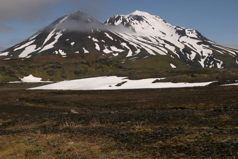
Photo : Jones, I. L. 30 Juin 2004.
Costa Rica , Turrialba / Poas / Rincon de la Vieja :
Volcanic monitoring program weekly bulletin February 11, 2020
Turrialba volcano
Lat: 10.025 ° N; Long: 83.767 ° W;
Altitude: 3340m
Current activity level: 2 (active volcano)
Potentially associated hazards: gas, emission of ash, proximal ballistic projections.
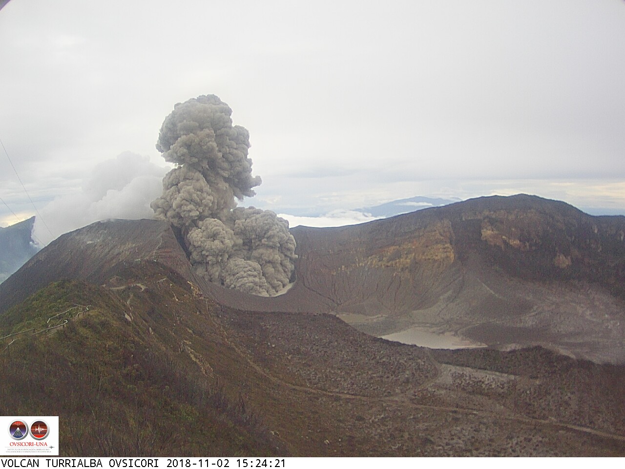
No ash emission was detected. Seismicity has a stable number of LPs, few VTs and a small deep explosion without surface manifestation. The volcanic building shows a contraction. The CO 2 / SO 2 and H 2 S / SO 2 ratios remain within a normal range during this period and the flow of SO 2 is kept low (~ 100 t / d). A flyover carried out using a drone made it possible to measure the depth of the crater, which reaches 140 m (compared to 220 m measured in 2019), that is to say that the crater fills due to the frequent collapse of the walls internal.
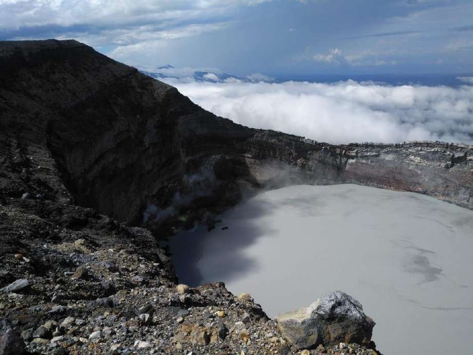
Poás Volcano
Lat: 10.2 ° N; Long: 84.233 ° W;
Altitude: 2780 m
Current activity level: 3 (active volcano)
Potentially associated hazards: gas, ash emission, phreatic eruptions, proximal ballistic projections.
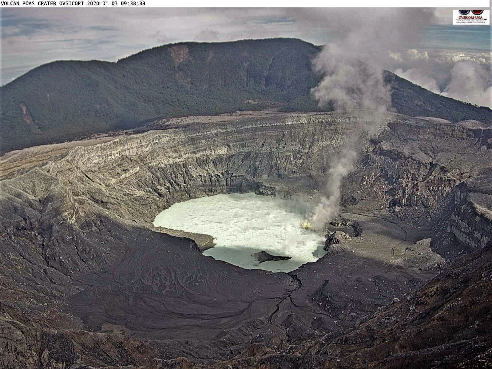
Seismic activity presents a stable pattern of fluctuations in the number of LP type events. Although the distortions are not significant, there is a tendency for inflation. The CO 2 / SO 2 ratio remains stable except for a peak on February 9. There is almost no H 2 S. The flow of SO 2 showed a significant increase over the weekend (February 8-9). The gases significantly affected visitors to the national park on February 7, with an average of 15 ppm SO 2 in 1 minute. The lake level dropped, especially during the weekend (February 8-9). In the lake, a high Cl – / SO 4 2- ratio was confirmed.
Rincon de la Vieja volcano
Lat: 10.83 ° N; Long: 85.324 ° W;
Altitude: 1895m
Current activity level: 3 (volcanic eruption)
Potentially associated hazards: gas, phreatic eruptions, proximal ballistic projections, lahars.
The last phreatic eruption was recorded on January 30. The seismicity has stabilized: the tremor continues with a slow decrease in amplitude, events of the LP type and of the Tornillos type still occur. There is no significant deformation, but a tendency towards inflation of the volcanic building. In thermal springs, the parameters of conductivity and reduction of oxides tend to return to values similar to those recorded before the eruption. An overview organized by the CNE revealed that the lake level is 4m higher than in April 2018.
Source : Ovsicori .
Photos : Ovsicori , Waldo Taylor de ICE.
Indonesia , Kerinci :
VOLCANO OBSERVATORY NOTICE FOR AVIATION – VONA.
Issued: February 16 2020
Volcano: Kerinci (261170)
Current Aviation Colour Code: YELLOW
Previous Aviation Colour Code: yellow
Source: Kerinci Volcano Observatory
Notice Number: 2020KER05
Volcano Location: S 01 deg 41 min 49 sec E 101 deg 15 min 50 sec
Area: Jambi, West Sumatra, Indonesia
Summit Elevation: 12176 FT (3805 M)
Volcanic Activity Summary:
On 16 february 2020, observed brown ash emission at 23:00 UTC ( 06:00 Local Time ).
Volcanic Cloud Height:
Best estimate of ash-cloud top is around 13456 FT (4205 M) above sea level, may be higher than what can be observed clearly. Source of height data: ground observer.
Other Volcanic Cloud Information:
Ash emission moving southwest.
Remarks:
Seismic activity is dominated by gas emission and continuous vulcanic tremor with amplitude 0,5-2 mm (dominan 1mm).
Level of activity at level II (WASPADA). G. Kerinci (3,805 m above sea level) experienced a continuous eruption. The most recent eruption occurred on January 24, 2020, resulting in an eruption column height of 500 m. The color of the gray column was observed to be gray.
Volcano covered with fog. No smoke from the crater is observed. Sunny to cloudy weather, moderate southwest winds. The temperature is around 21-24 ° C.
According to the seismographs of February 15, 2020, it was recorded:
79 emission earthquakes
Continuous tremor, amplitude 0.5-2 mm (dominant 1 mm)
Recommendation:
Communities around Kerinci volcano and visitors / tourists are not allowed to climb to the crater at the top of Kerinci volcano within 3 km of the active crater (people are prohibited from doing activities within the danger radius / KRB III).
The flight path around the Kerinci volcano should be avoided because at any time, it still has the potential for ash eruptions with an altitude that can interfere with aircraft.
Source : PVMBG.
Photo : Wild Sumatra