March 27 , 2024.
Iceland : Reykjanes Peninsula :
Volcanic activity appears to have decreased. High levels of SO2 (Sulfur Dioxide) were measured over the weekend. Unchanged hazard assessment
Updated 25. March at 16:30 UTC
High levels of SO2 (Sulfur Dioxide) were measured over the weekend. Gas dispersion forecast can be followed here .
This concentration of SO2 is considered very unhealthy. It is important to pay close attention to developments in air quality.
Volcanic activity appears to have decreased at Sundhnúksgíga.
The hazard assessment remains unchanged. Increased hazards persist due to gas emissions
Volcanic activity at Sundhnúksgíga appears to have decreased over the past few days. Activity in the vents has decreased and possibly ceased in the smallest craters. Additionally, volcanic tremor has gradually diminished over the past few days. The main lava flow runs southward from the vents and then bends westward. Over the weekend, lava continued to flow into Melhólsnáma and has now filled it. However, the lava also continues to thicken near the craters.
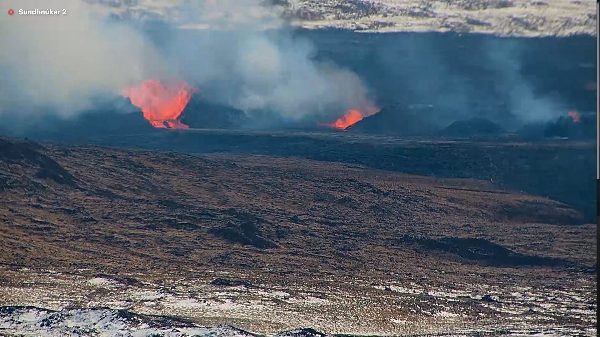
GPS measurements in recent days indicate ongoing land rise in Svartsengi, but it exhibits a slower rate than before. This suggests that magma continues to accumulate in the reservoir beneath Svartsengi despite the ongoing eruption.
High levels of SO2 measured past few days
High levels of SO2 have been measured in Höfn and Grindavík the past few days. This concentration is considered very unhealthy, and people are likely to experience respiratory symptoms if exposed. It is important to stay indoors, close windows, and turn off air conditioning. This is especially important where outdoor work is being carried out, as stated by the work safety authorities; companies and institutions in the southwest region of the country must pay close attention to further developments in air quality due to the potential risk of gas pollution. People in the area are advised to monitor air quality and familiarize themselves with symptoms of air pollution from volcanic gases.
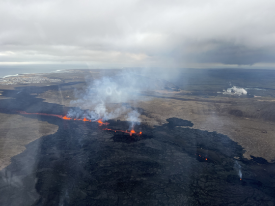
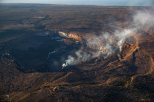
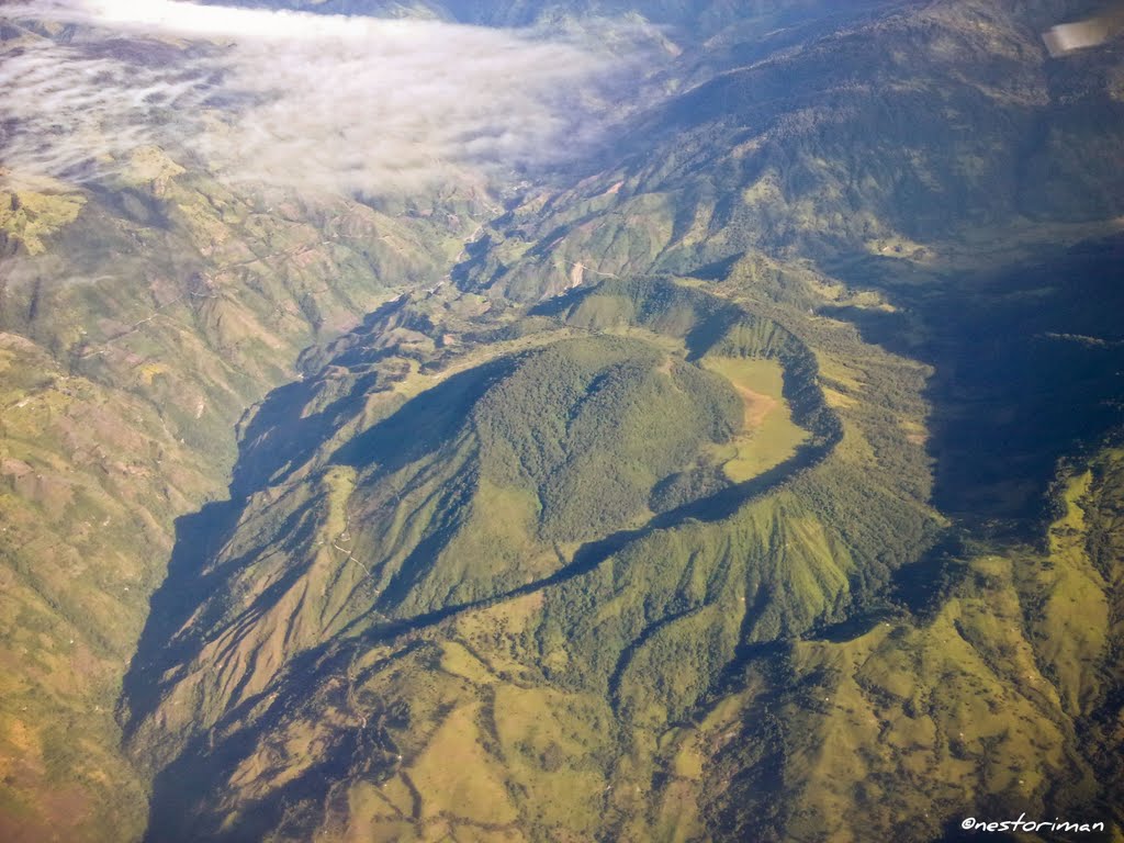
Overall photo of the eruptive centers taken in flight (March 20, 2024). There you can see all the active craters and a lava flow coming out of them towards the South. In the background, on the left you can see Grindavíkurbær and on the right, Svartsengi (Photo: Birgir V. Óskarsson – Natural Science Foundation)
The weather forecast for today predicts northeasterly winds of 3-8 m/s at the eruption sites, with the pollution drifting southwestward (over Grindavík and Svartsengi); gas may accumulate near the eruption sites due to slow wind speeds. In the evening, night, and early morning hours, winds are expected to come from the east at 8-13 m/s at the eruption sites, causing pollution to drift westward, towards areas including Hafnir. During this period, it’s also possible that the wind may become southeasterly at times, potentially causing pollution in Njarðvík, Keflavík, and Sandgerði. By late afternoon tomorrow (Tuesday), winds will shift to be northeasterly at 3-8 m/s, causing the gas pollution to drift southwestward (over Grindavík and Svartsengi) and possibly to accumulate near the eruption sites due to light winds.
Source : IMO.
Photo : Birgir V. Óskarsson – Fondation des sciences naturelles ,Óróapúls – Volcanisme en Islande
Iceland , Askja :
Seismic swarm in the northwest past of the caldera in Askja yesterday . Deformation continues in the area
March 26 , 2024
Yesterday (25 March) a seismic swarm occurred in the NW part of the Askja caldera. About 30 earthquakes were detected between 08.00UTC and midday. The largest earthquake detected had a magnitude M3,5 at a depth of about 5 km. Three earthquakes with magnitudes between M2 and M2,5 were also detected, the rest of the activity was characterized by smaller events. Overall, the seismic activity in the Askja has been quite stable between months and unchanged until yesterday. Looking back, we can see that earthquakes with magnitude above M3 were detected in January 2022 and October 2021.
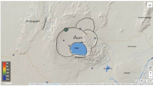
The map shows the location of the earthquake swarm yesterday on the NW-ern rim of Askja caldera. Blue boxes mark the locations of GNSS monitoring instruments.
Deformation at Askja continued with a stable rate for two years since the end of summer 2021. In the last autumn, the GNSS data indicated though a change in velocity as reported in a dedicated news piece.
However, the most recent ground deformation measurements based on GNSS data suggest that the rate has increased again, even though it remains at lower rates as observed prior the autumn in 2023. Additional data, which will be collected in the next days, will help in clarifying and confirming the trend of the deformation process in the area.
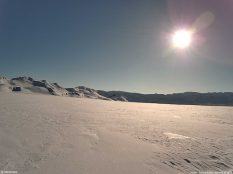
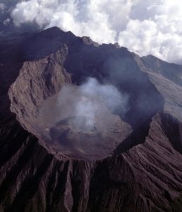
Photo from IMO’s webcam located in Askja caldera looking at the southern part of the caldera rim. Photo is taken 10. March 2024
A satellite image acquired on 19 March shows a typical winter view of Askja lake, where most of the lake is covered by ice except for those two well-known areas characterized by persistent geothermal activity. In February last year, Askja lake was ice-free and considered unusual for that time of year.
Source : IMO
Italy , Stromboli :
WEEKLY BULLETIN, from March 18, 2024 to March 24, 2024. (issue date March 26, 2024)
SUMMARY STATEMENT OF ACTIVITY
In light of the monitoring data, it appears:
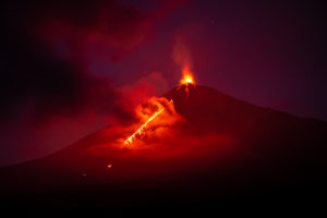
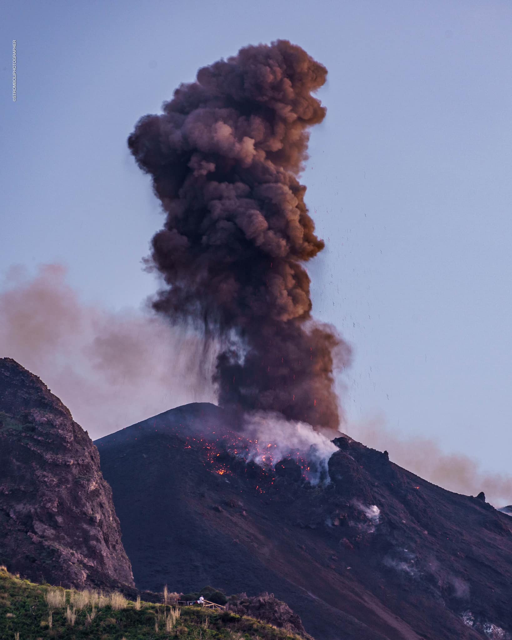
1) VOLCANOLOGICAL OBSERVATIONS: Normal Strombolian activity was observed during this period. The total hourly frequency of explosions fluctuated around average values (8 to 15 events/hour). The intensity of the explosions was mainly low to medium in the areas of the North and South-Central craters.
2) SISMOLOGY: The monitored seismological parameters do not show significant variations.
3) GROUND DEFORMATIONS: The soil deformation monitoring networks do not show significant variations.
4) GEOCHEMISTRY: low-medium level SO2 flux
There are no updates for the CO2 flux in the summit area.
C/S ratio in the plume: there are no updates.
The helium isotope ratio in the thermal aquifer remains at high values.
CO2 flux in Scari: stable values at average levels.
5) SATELLITE OBSERVATIONS: Thermal activity observed by satellite was generally low level with some rare and isolated thermal anomalies of moderate level.
VOLCANOLOGICAL OBSERVATIONS
In the observed period, the eruptive activity of Stromboli was characterized through the analysis of images recorded by the INGV-OE surveillance cameras located at Pizzo sopra la Fossa.
(SPT), at 190 m altitude (SCT-SCV) and at Punta dei Corvi (SPCT). The explosive activity was mainly produced by 2 eruptive chimneys located in the North crater area and by 3 chimneys located in the South-Central crater area.
Observations of explosive activity captured by surveillance cameras
In correspondence with the area of the North crater (N), characterized by a mouth located in sector N1 and a mouth located in sector N2, low intensity explosive activity was observed (the erupting products reached a height less than 80 m) in sector N2, while in sector N1 the intensity was low to medium (height less than 150 m). The products emitted in the eruption were mainly coarse materials (bombs and lapilli). The average frequency of explosions fluctuated between 2 and 4 events/hour.
In the South-Central (CS) zone, sector C did not show significant activity, while sector S1 showed a low-intensity explosion of coarse materials. In sector S2, comprising at least two emission points, the explosions were of varying intensity from low (height less than 80 m) to medium (height less than 150 m) and sometimes even high (height greater than 150 m) with emission of coarse particles. material sometimes mixed with fine materials. The average frequency of explosions varied between 6 and 11 events/hour.
Source : INGV
Photo : Stromboli stati d’animo / Sebastiano Cannavo.
Colombia , Cerro Machin :
Weekly Activity Bulletin: Cerro Machín Volcano
Regarding the monitoring of the activity of the CERRO MACHÍN VOLCANO, the MINISTRY OF MINES AND ENERGY, through the COLOMBIAN GEOLOGICAL SERVICE (SGC), reports that:
During the week of March 19-25, 2024, the volcano continued to record seismicity associated with fracturing of rock inside the volcanic building. Compared to the previous week, this seismic activity presented a considerable increase in the number of earthquakes recorded and the seismic energy released. The earthquakes were located mainly under the main dome and, to a lesser extent, on the West and South-West flanks of the volcanic edifice, at distances less than 3 km. The depths of the earthquakes varied between 3 and 4 km under the main dome, and between 1 and 4 km in the sectors mentioned.
During the seismic increase recorded on March 23, between 2:25 a.m. mr. and 7:00 a.m. the highest number of earthquakes and largest magnitudes of the week occurred. This seismic increase was located under the main dome, in its West and South-West sectors. The largest earthquakes were 4.2 and 4.0, they occurred at 2:25 a.m. mr. and 2:30 a.m. in the West-Northwest (3 km depth) and West-Southwest (4 km depth) sectors of the main dome, respectively. Both earthquakes were reported as felt by residents of the area of volcanic influence and the towns of Cajamarca, Ibagué, Armenia, Montenegro and Calarcá. It is important to mention that earthquakes of magnitude greater than or equal to 4.0 have not been recorded since the seismic increase of December 2, 2022.
The other parameters measured and used for the diagnosis of volcanic activity did not present significant changes during the period evaluated.
The alert status for volcanic activity remains at YELLOW ALERT: ACTIVE VOLCANO WITH CHANGES IN THE BEHAVIOR OF THE BASE LEVEL OF MONITORED PARAMETERS AND OTHER MANIFESTATIONS.
Source : SGC
Photo : Nestoriman
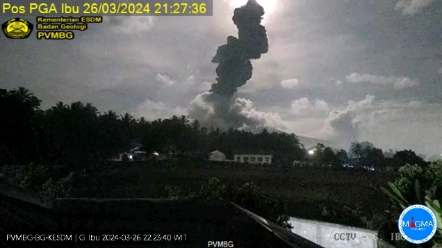
Indonesia , Ibu :
An eruption of Mount Ibu occurred on Tuesday March 26, 2024 at 9:27 p.m. WIT with the height of the ash column observed at ±2800 m above the summit (±4125 m above sea level). The ash column was observed to be gray with thick intensity, oriented towards the West. This eruption was recorded on a seismograph with a maximum amplitude of 28 mm and a duration of 249 seconds.
Observation of seismicity:
23 earthquakes eruptions explosions with an amplitude of 24 to 28 mm and a seismic duration of 32 to 96 seconds.
47 emission earthquakes with an amplitude of 6.5 to 20 mm and earthquake duration of 12 to 43 seconds.
252 Shallow volcanic earthquakes with an amplitude of 2.5 to 20 mm and an earthquake duration of 5 to 18 seconds.
18 deep volcanic earthquakes with an amplitude of 4 to 12 mm, and an earthquake duration of 4 to 9 seconds.
5 local tectonic earthquakes with an amplitude of 2.5 to 10 mm, with an earthquake duration of 22.12 to 67 seconds.
5 distant tectonic earthquakes with an amplitude of 1.5 to 16 mm, and earthquake duration 51 to 159 seconds.
RECOMMENDATION
1. Communities around Mount Ibu and visitors/tourists should not practice activities within a radius of 2.0 km and a sectoral extension of 3.5 km towards the crater opening in the northern part of the active crater from Mount Ibu.
2. In the event of ash falling, people who carry out activities outside the house are advised to protect their nose, mouth (mask) and eyes (glasses).
Source et photo : Magma Indonésie