February 05 , 2020 .
Colombia , Nevado del Ruiz :
The new lava dome of the Nevado del Ruiz volcano and the current geomorphology of the Arenas crater, January 31, 2020.
Summary:
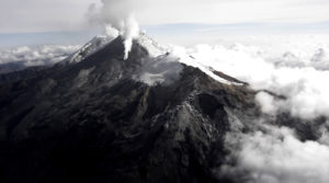
The Nevado del Ruiz volcano (VNR), located in the Central Cordillera of Colombia, is considered one of the most active volcanoes in the country and has been monitored since 1985 by the Manizales Volcanological and Seismological Observatory of the Colombian Geological Service. The current morphology of the summit of the VNR (5321 m above sea level) and its main crater is the consequence of: the complex interaction between volcanic ─ effusive and explosive processes, the distribution of volcanic deposits, the erosion caused by warming and the dynamics of ice cover (Figure 1).
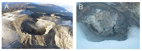
Figure 1. Photographs of the 2020 (A) and 2010 (B) VNR summit, taken over with support from the Colombian Air Force (FAC). It is noted: the Arenas crater, the upstream waters of the Azufrado river, the area of the ice cap adjacent to the crater, the deposit of ash, the emission of gas and vapor and the walls of the interior ledges.
Morphology:
The morphology of the main crater of the VNR, called Arenas, was configured following activity after the eruptions of 1845, 1985, 1989 and 2012, the instability of the volcanic system produced by the current activity cycle (2010- 2020) and the dynamics of glaciers Currently, the Arenas crater has an irregular and elongated morphology, a diameter greater than 980 m in the direction SW-NE, a diameter less than 900 m in the direction SE-NW and an approximate depth of 300 m (Figure 1). The Arenas crater has large depressions contained in cornices or smaller terraces, internal walls, a bottom and several fields of fumaroles with emission of gas and ash. These fumarole fields remained with intermittent activity after the eruptions of 1985 and 1989 and with great intensity during the current activity cycle (2010-2020).
The upper part (the most superficial area) of the volcanic duct of the Nevado del Ruiz volcano is located just below the Arenas crater (Figure 1B). This area of the volcano is considered the most unstable and until August 2015, it was characterized by the presence of multiple active sources of emission of water vapor, sulfur dioxide (SO2) and other volcanic gases, accompanied by ash emissions.
Current cycle of activity and lava dome:
The current activity cycle of the Nevado del Ruiz volcano was preceded by 8 years of stability and low levels of seismicity, during which time the activity level remained green. In September 2010, the seismicity associated with fluid dynamics and SO2 emission increased. This increase resulted in a change in activity level (from green to yellow). In 2012, the Nevado del Ruiz volcano continued to show behavioral changes. In March, seismicity associated with fluids, emission of water vapor and SO2, ash emissions and deformation increased. This increase resulted in a new change in activity level (from yellow to orange).
While it was at Orange activity level (anticipation of an eruption occurring in a few days to a few weeks), the Nevado del Ruiz had two minor eruptions in May and June 2012. These eruptions were small, with eruptive columns less than 10 km high, with the generation of small mudslides (affecting the proximal area of the volcano) which did not cause loss of life. The proper management of this crisis has enabled the SGC to successfully manage volcanic risks.
After the eruptions of 2012, the Nevado del Ruiz maintained an unstable behavior with: occurrence of earthquake (associated with fracturing of rocks and fluid dynamics inside the volcanic system), permanent emissions (mainly vapor from (water, SO2 and ash) and record of continued high inflation of the volcanic building. In August 2015, a new magma was located and a lava dome began to develop at the bottom of the Arenas crater, which continued to grow for several months, reaching a larger diameter estimated at 173 m in January 2020, a maximum height estimated 60 m and an approximate volume of 1,500,000 m3 (Figures 2, 3 and 4).
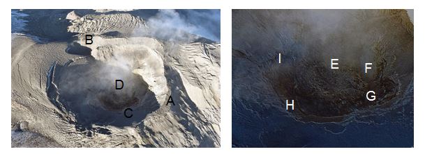
Figure 2. Photographs of the Arenas crater from January 2020, taken overflight with the support of the CAF. We observe: the edge of the crater (A), a secondary crater 150 m in diameter located to the West (B), the interior cornices (C), the lava dome (D), a depression in the center of the dome caused by a possible subsidence and cooling of the lava (E), a gas and ash emission center with a diameter of about 15 m (secondary crater) (F) and several sources of gas emission located around the crater (G, H e I).
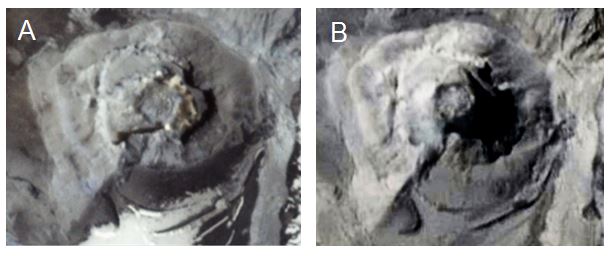
Figure 3. Images captured by the PlanetScope satellite system on March 14, 2018 (A) and January 10, 2020 (B). In the two images, you can see the lava dome located at the bottom of the Nevado del Ruiz crater. Courtesy of Planet Lab Inc. (https://www.planet.com/).

Figure 4. Sketch of the Arenas crater and its main morphological features, including the lava dome.
The areas identified in Figure 4 show good correspondence with the satellite information available for the Arenas crater area. Figure 5 shows some thermal images of the interior of the crater which were captured by the multispectral sensor of the Sentinel-2 satellite system of the European Space Agency (ESA). These images correspond to a spectral combination which responds appropriately to the temperatures inside the crater: Sentinel-2 bands B12 (SWIR2), B11 (SWIR1) and B8 (NIR), where the coldest seems blue and red and warmest yellow. The area of thermal anomalies located towards the northwest edge of the dome is highlighted, proposed as a possible secondary crater.

Figure 5. Thermal images captured by the Sentinel-2 satellite system for the Arenas crater area on March 10, 2018 (A), December 10, 2018 (B), December 20, 2019 (C) and January 4, 2020 (D) . The zones of thermal anomalies associated with the sources of degassing and emission of ash are observed.
Source : SGC , Milton Ordóñez, Carlos Laverde y Cristian López / Servicio Geológico Colombiano-Observatorios Vulcanológico.
Mexico , Michoacán :
The National Seismology Service (SSN) has reported that there has been a seismic swarm of hundreds of events in Michoacán since January 5.
A seismic swarm is a series of earthquakes that occur in a specific region, during a given period and with similar magnitudes.
Through its Twitter account, the agency said it reported 1,611 earthquakes with magnitudes between 2.9 and 4.1 degrees on the Richter scale in just one month, the majority of which were north of Uruapan.
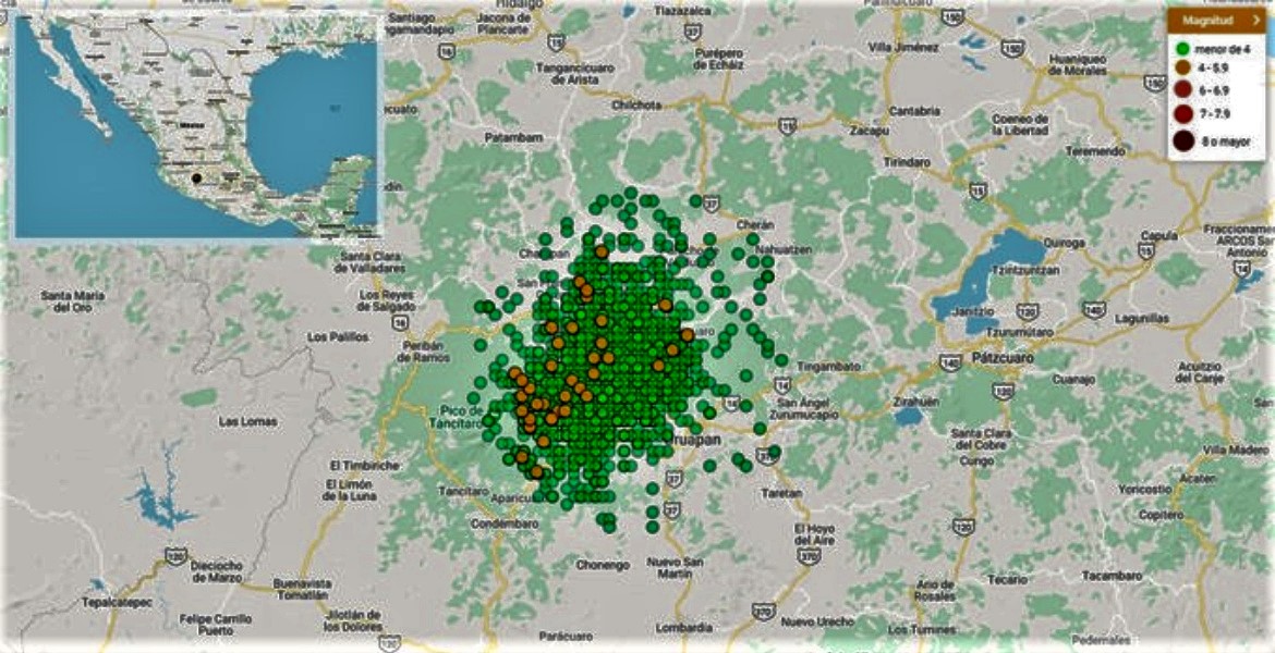
He emphasized that Michoacán is a seismic zone with complex tectonics and active volcanism. The region where this swarm occurs is in the trans-Mexican volcanic belt.
He noted that these tremors occurred very close to the extinct Paricutin volcano and the Tancítaro volcano, so that they could come from a magmatic intrusion, however, this does not necessarily imply the birth of a volcano.
Authorities and specialists are already working on sampling and installing measurement equipment to investigate the origin of this seismic swarm.
According to the SSN, in January 2019, 848 seismic movements were recorded, a much lower number than that presented in the first month of 2020.
Historically, major earthquakes have occurred along the coast of this state following the subduction of the Cocos plate under the North American plate.
Source : Diariodemexico
Read the article : https://www.diariodemexico.com/ssn-registra-enjambre-sísmico-en-michoacán?fbclid=IwAR316fsLDQiTHz5NK7o9w1fwNU6pDqFRHR4G2dXBhUk2ql21TgOUpUp9ae0
Italy / Sicily , Etna :
Weekly bulletin from 27/01/2020 to 02/02/2020 (issue date 04/02/2020).
SUMMARY OF ACTIVITY STATUS
In light of the monitoring data, it is highlighted:
1) VOLCANOLOGICAL OBSERVATIONS: Strombolian and effusive intra-crater activity of the Voragine crater and low ash emission from the North-East crater.
2) SEISMOLOGY: absence of seismicity by fracturing with Ml greater than or equal to 2.0; stationarity in the parameters of the volcanic tremor.
3) INFRASOUND: sustained infrasound activity.
4) DEFORMATIONS: Analysis of data from GPS networks and tiltmeters does not show significant variations.
5) GEOCHEMISTRY: SO2 and HCl fluxes are at an average level. Soil CO2 flow values are low to medium. The partial pressure of dissolved CO2 does not show significant variations. The isotopic ratio of helium (data from January 28) confirms medium-high values. No update on the CO2 / SO2 ratio is available. The last figure for January relates to average values.
VOLCANOLOGICAL OBSERVATIONS:
During the week, monitoring of Etna activity was carried out using surveillance cameras from the INGV – Catania section and through an inspection carried out in the upper area by INGV staff .
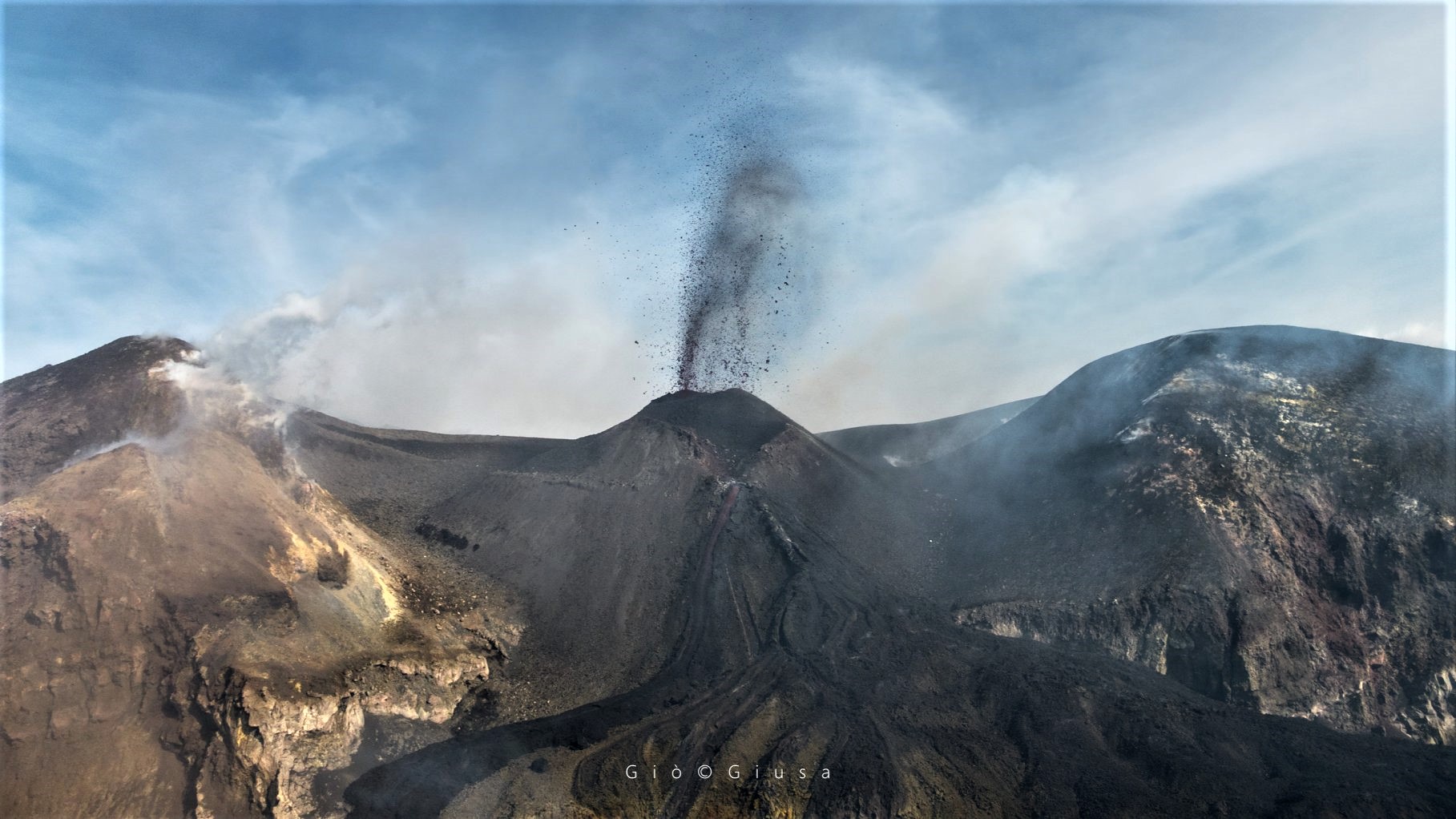
During the period studied, the eruptive activity of Etna was almost exclusively carried by the crater of Voragine (VOR); the Northeast Crater (NEC) emitted very dilute ash and the New Southeast Crater (NSEC) was the site of intense degassing.

In detail, the intra-crater eruption continues in Voragine which, during the observation period, produced Strombolian explosions with shreds visible by the cameras placed on the Montagnola. Low ash emissions quickly dispersed into the atmosphere, and a lava effusion from the southern flank of the slag cone that developed inside developed. Lava flows continue to flow into the adjacent Bocca Nuova (BN) crater.
As for the North-East crater, this one, between January 28 and 29, 2020, was characterized by a low emission of very diluted ash.
From the inspection carried out on February 1, 2020 by INGV staff, it was possible to observe the continuous strombolian activity of the intra-crater cone of Voragine with projection of shreds, gas emission and low content in ashes and as well as an effusive activity. In particular, the lava flow which comes out of an eruptive mouth open on the South side of the intracrater cone,, at the break of slope, divides several lava flows, of which at least three are clearly distinguished. In general, the overlap of several streams over time has created a lava field which has completely filled the BN-2. During the inspection, it was possible to note that the active lava flows were already pouring into BN-1.
Source : INGV.
Read the article : file:///C:/Users/Utilisateur/AppData/Local/Packages/Microsoft.MicrosoftEdge_8wekyb3d8bbwe/TempState/Downloads/BollettinoEtna20200204%20(1).pdf
Photos : Gio Giusa.
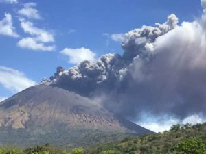
Philippines , Taal :
TAAL VOLCANO BULLETIN: 05 February 2020 8:00 A.M.
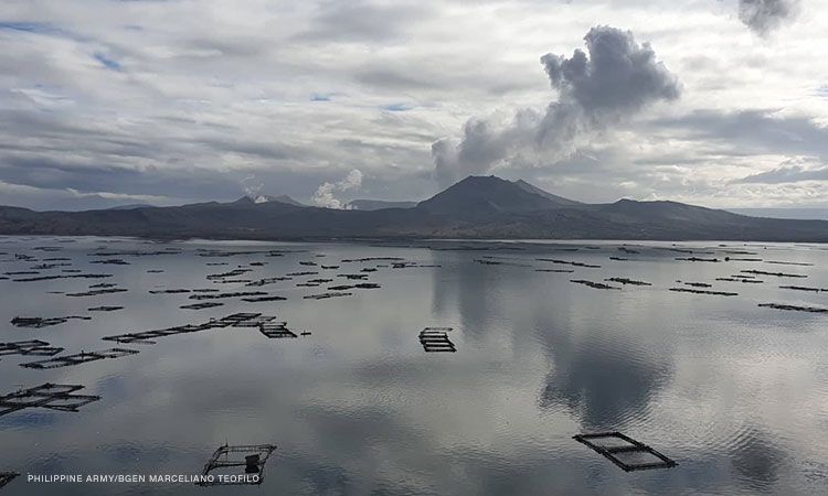
Activity in the Main Crater in the past 24 hours has been characterized by weak emission of steam-laden plumes 50 to 100 meters tall that drifted southwest. Sulfur dioxide (SO2) emission was measured at an average of 55 tonnes/day on February 4, 2020.
The Taal Volcano Network recorded one-hundred fifty-six (156) volcanic earthquakes including two (2) low-frequency events and eighteen (18) harmonic tremors having durations of one (1) to three (3) minutes. These earthquakes signify magmatic activity beneath the Taal edifice that could lead to eruptive activity at the Main Crater.
Source : Phivolcs .
Photo : CNNPH , Marcello Teofilo.
Indonesia , Semeru :
VOLCANO OBSERVATORY NOTICE FOR AVIATION – VONA .
Issued: February 04 , 2020 .
Volcano: Semeru (263300)
Current Aviation Colour Code: ORANGE
Previous Aviation Colour Code: orange
Source: Semeru Volcano Observatory
Notice Number: 2020SMR14
Volcano Location: S 08 deg 06 min 29 sec E 112 deg 55 min 12 sec
Area: East java, Indonesia
Summit Elevation: 11763 FT (3676 M)
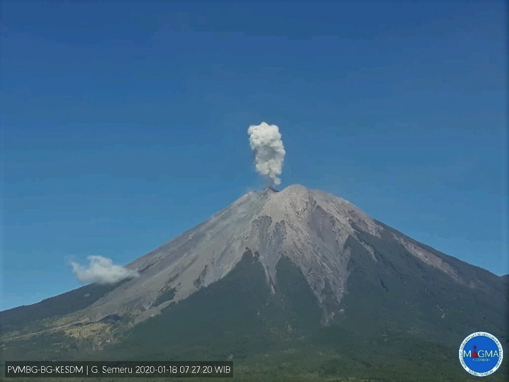
Volcanic Activity Summary:
Eruption with volcanic ash cloud at 23h26 UTC (06h26 local).
Volcanic Cloud Height:
Best estimate of ash-cloud top is around 13043 FT (4076 M) above sea level, may be higher than what can be observed clearly. Source of height data: ground observer.
Other Volcanic Cloud Information:
Ash cloud moving to north
Remarks:
Seismic activity is characterized by eruption, avalanche and gas emission earthquakes
Source : Magma Indonésie .
Photo : archive PVMBG.