October 22 , 2023.
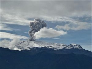
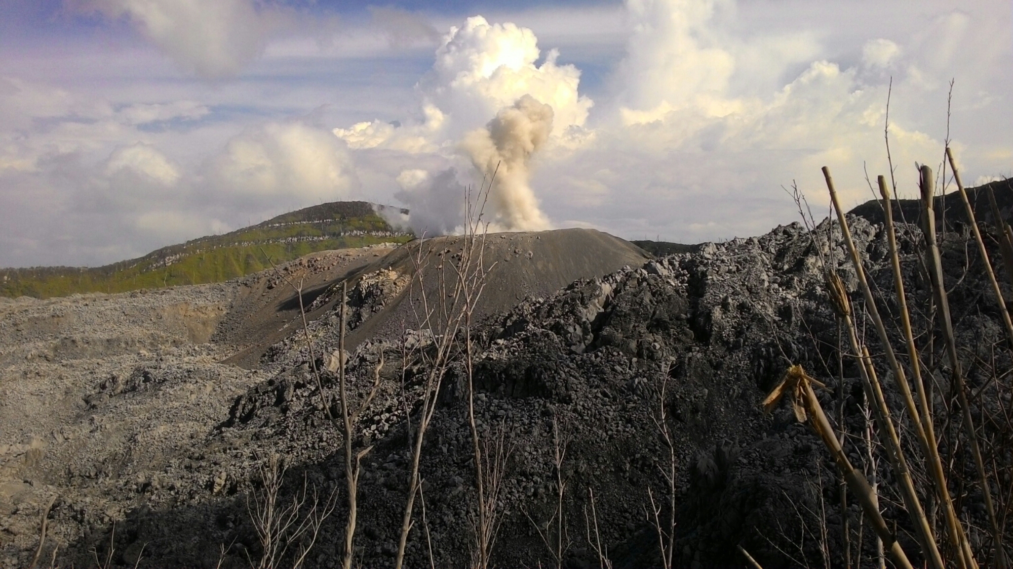
Colombia , Nevado del Huila :
Popayan, October 21, 2023, 11:10 a.m.
From the monitoring of the activity of the NEVADO DEL HUILA VOLCANO, the MINISTRY OF MINES AND ENERGY through the COLOMBIAN GEOLOGICAL SERVICE (SGC) reports that:
At 00:38 local time, an earthquake with a magnitude of M3.6 occurred at a depth of one (1) kilometer below the central peak of the Nevado del Huila volcano. From this time until 08:00 local time, 320 earthquakes associated with the fracturing of rock inside the volcano were recorded. These earthquakes were located in the zone of influence of the Nevado del Huila volcano, at epicentral distances between 0.5 and 2 km, approximately from the Central Peak. In addition, two other earthquakes reached magnitudes greater than two (2.0 and 2.9).
Felt earthquakes are phenomena considered in the yellow alert state, as well as the formation of domes, cracks in the glacier, low-energy thermal anomalies, noises, among others. It is recommended that authorities and the community continue to be attentive to any changes that may occur in the activity of the volcano.
The alert status of the volcano remains at the level:
YELLOW: Active volcano with changes in the behavior of the base level of monitored parameters and other manifestations.
The COLOMBIAN GEOLOGICAL SERVICE will continue to monitor the evolution of the volcanic phenomenon and will inform in a timely manner of any changes that may occur.
Source : SGC.
Photo : Parque Nacional
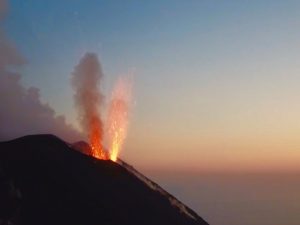
Indonesia , Ibu :
Mount Ibu exhibited an eruption on Saturday, October 21, 2023 at 9:30 p.m. WIT with the height of the ash column observed at ±800 m above the summit (±2,125 m above sea level). The ash column was observed to be gray in color with thick intensity, oriented towards the South-West. This eruption was recorded on a seismograph with a maximum amplitude of 28 mm and a duration of 62 seconds.
VOLCANO OBSERVATORY NOTICE FOR AVIATION – VONA
Issued : October 21 , 2023.
Volcano : Ibu (268030)
Current Aviation Colour Code : ORANGE
Previous Aviation Colour Code : orange
Source : Ibu Volcano Observatory
Notice Number : 2023IBU044
Volcano Location : N 01 deg 29 min 17 sec E 127 deg 37 min 48 sec
Area : North Maluku, Indonesia
Summit Elevation : 4240 FT (1325 M)
Volcanic Activity Summary :
Eruption with volcanic ash cloud at 12h30 UTC (21h30 local).
Volcanic Cloud Height :
Best estimate of ash-cloud top is around 6800 FT (2125 M) above sea level or 2560 FT (800 M) above summit. May be higher than what can be observed clearly. Source of height data: ground observer.
Other Volcanic Cloud Information :
Ash cloud moving to southwest. Volcanic ash is observed to be gray. The intensity of volcanic ash is observed to be thick.
Remarks :
Eruption recorded on seismogram with maximum amplitude 28 mm and maximum duration 62 second.
Source : Magma Indonésia
Photo : J Massolo
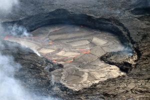
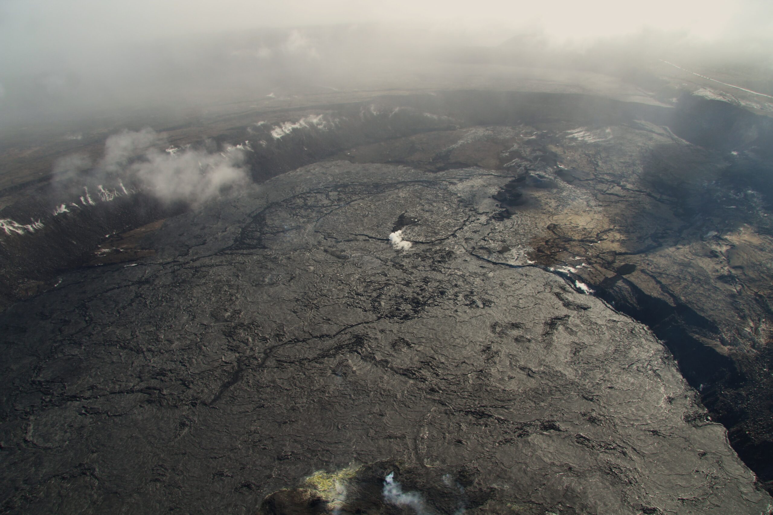
Hawaii , Kilauea :
Saturday, October 21, 2023, 8:42 AM HST (Saturday, October 21, 2023, 18:42 UTC)
19°25’16 » N 155°17’13 » W,
Summit Elevation 4091 ft (1247 m)
Current Volcano Alert Level: ADVISORY
Current Aviation Color Code: YELLOW
Activity Summary:
Kīlauea volcano is not erupting. The unrest to the south-southwest of Kīlauea’s summit has increased over the past 24 hours in association with an intrusive event that began in early October. Unrest may continue to wax and wane with changes to the input of magma into the area. The summit of Kīlauea remains at a high level of inflation and eruptive activity is possible in the coming weeks or months. No unusual activity has been noted along Kīlauea’s East Rift Zone or the Southwest Rift Zone.
Summit Observations:
Unrest to the south and southwest of the summit area of Kīlauea has increased over the past day, following a few days of decline. Such waxing and waning of unrest may continue.
Renewed seismicity beneath the south end of Kīlauea caldera extending to the southwest along the trend of December 1974 vents began on October 16. The renewed activity peaked on October 17 and decreased through much of yesterday, October 20. Around 7 pm last night, seismic unrest began to increase again to a level close to that seen on the 17th. Over the past 24 hours, approximately 96 earthquakes were recorded in Kīlauea’s summit region, up from only 4 during the previous day. Most of the earthquakes related to this unrest are at depths of around 1–3 km (0.6–2 mi) below the surface.
The Uēkahuna summit tiltmeter located north of the caldera was generally flat over the past day. The Sand Hill tiltmeter, located just southwest of the caldera, showed ongoing inflation over the past 24 hours. Overall, inflation at the summit of Kīlauea remains high and has surpassed the level seen just before the most recent eruption on September 10th. However, the current rate of inflation in the region has diminished significantly since October 4-6.
Sulfur dioxide (SO2) emission rates remain low and were measured at a rate of about 100 tonnes per day on October 19.
It is unclear if unrest in Kīlauea summit region will continue and, at this time, it is not possible to say with certainty if activity will lead to an eruption; activity may remain below the ground surface. However, an eruption remains possible, most likely in Kīlauea’s summit region inside of Hawai‘i Volcanoes National Park and away from infrastructure. Similar patterns of earthquake activity and ground deformation occurred to the south of the caldera prior to the September and June 2023 eruptions in Kīlauea summit caldera (in Halemaʻumaʻu crater and on the downdropped block). Volcanic gas emissions pose the greatest hazard to areas downwind of Kīlauea’s summit.
There is currently no sign of an imminent eruption and increasing inflation and earthquake activity (heightened unrest) are expected to precede an eruption. During periods of heightened unrest prior to recent eruptions at Kīlauea summit, signs of imminent eruption did not appear until 1-2 hours before lava reached the surface. The summit of Kīlauea remains at a high level of inflation and eruptive activity is possible in the coming weeks or months. HVO scientists will continue to monitor Kīlauea volcano closely and will issue additional messages as warranted by changing activity.
Source : HVO
Photo : USGS / M. Zoeller.
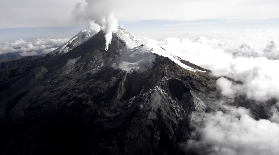
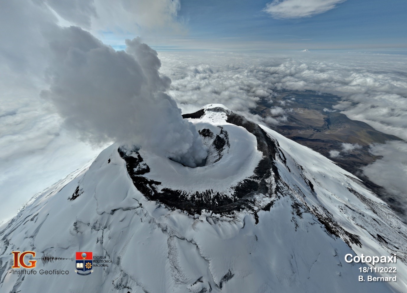
Ecuador , Cotopaxi :
On October 21, 2022, the Cotopaxi volcano began an eruptive period which lasted more than 9 months. During this period, the most frequent eruptive phenomenon was the emission of ash, water vapor and gas. Activity was most intense between December 2022 and February 2023, when up to ten ash emissions were recorded per week, most at low altitude (<1 km above crater level) and with low ash content. As a result, several ash falls were recorded near the Cotopaxi National Park (PNC), but sometimes their extent was greater, reaching populated areas in the cantons of Latacunga, Mejía, Rumiñahui and Quito. However, since the end of February 2023, a gradual decrease has been observed in the trends of monitoring parameters of the Cotopaxi volcano, both in internal and surface activity. Internally, the evolution is marked mainly by a reduction in the number of earthquakes: (tremors: associated with ash emissions; and long-period events (LP): associated with the movement of fluids); as well as a slowing of deformation patterns. At surface level, the reduction in activity resulted in a reduction in the number of ash emissions and the mass of ash emitted, as well as the height of the water vapor and ash emission columns. gas. The last emission of ashes was recorded on July 6, 2023.
Based on the observed decrease in monitoring parameters, the volcano activity is classified as LOW level with an unchanged trend both at SURFACE level and interior.
All monitoring parameters and visual observations suggest that the eruptive process of the Cotopaxi volcano that began on October 21, 2022 has ended or is about to end, however, possible future reactivation is not excluded.
The evolution of Cotopaxi activity in the medium and long term is uncertain, due to the very nature of volcanic processes. However, for the moment, we consider that the most likely scenario in the short term (a few days or weeks) is a return to a state similar to that observed before October 2022.
Despite this change in the level of eruptive activity, the importance of keeping the monitoring system active and continuing the prevention tasks associated with the eruptive scenarios proposed for the Cotopaxi volcano is highlighted. The IG-EPN remains attentive and if changes occur in the conditions of the volcano, it will offer timely information to the authorities and the general population.
Source : IGEPN
Photo : IGEPN / Benjamin Bernard.
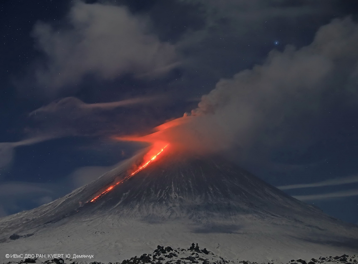
Kamchatka , Klyuchevskoy :
VOLCANO OBSERVATORY NOTICE FOR AVIATION (VONA)
Issued: October 22 , 2023
Volcano: Klyuchevskoy (CAVW #300260)
Current aviation colour code: ORANGE
Previous aviation colour code: orange
Source: KVERT
Notice Number: 2023-122
Volcano Location: N 56 deg 3 min E 160 deg 38 min
Area: Kamchatka, Russia
Summit Elevation: 4750 m (15580 ft)
Volcanic Activity Summary:
The summit explosive-effusive eruption of the volcano continues. Against the background of explosive activity of the Strombolian type (lava fountaining in the volcanic crater), the lava flows continue to effuse along the Apakhonchichsky and Kozyrevsky chutes on the southern slopes of the volcano. Lava flows in the Apakhonchichsky chute melt buried snowfields and glaciers. Powerful phreatic explosions are observed in the Apakhonchichsky chute, and collapses of old pyroclastic material from its sides. Satellite data by KVERT showed ash plume, containing mainly old ash from pyroclastic collapses from the sides of the Apakhonchich chute, is extending for 92 km to the northeast of the volcano.
The summit explosive-effusive eruption of the volcano continues. Ash explosions up to 7-8 km (23,000-26,240 ft) a.s.l. could occur at any time. Ongoing activity could affect international and low-flying aircraft.
Volcanic cloud height:
5000 m (16400 ft) AMSL Time and method of ash plume/cloud height determination: 20231022/0230Z – Himawari-9 14m15
Other volcanic cloud information:
Distance of ash plume/cloud of the volcano: 92 km (57 mi)
Direction of drift of ash plume/cloud of the volcano: NE / azimuth 56 deg
Time and method of ash plume/cloud determination: 20231022/0230Z – Himawari-9 14m15
Source : Kvert
Photo : Yu. Demyanchuk, IVS FEB RAS, KVERT ( 29/11/2020)