February 02 , 2020.
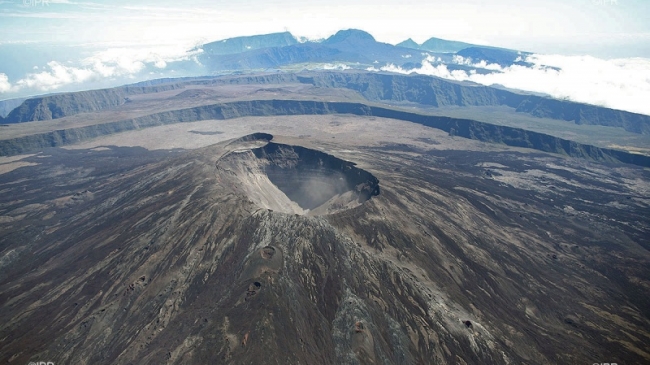
La Réunion , Piton de la Fournaise :
Monthly bulletin of Saturday February 01, 2020.
Seismicity:
In January 2020, the OVPF recorded at the level of the Piton de la Fournaise massif in total:
• 258 superficial volcano-tectonic earthquakes (0 to 2 km deep) under the summit craters;
• 15 deep earthquakes (> 2 km deep);
• 167 collapses (in the Crater Dolomieu and at the ramparts of the Enclosure Fouqué).
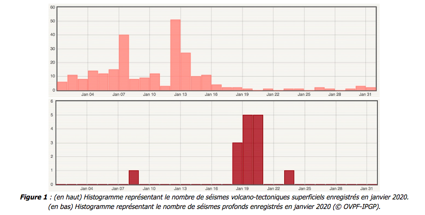
A resumption of seismicity was observed under the Piton de la Fournaise during the first half of January with 258 superficial volcano-tectonic earthquakes recorded under the summit craters between January 1 and 16, 2020. Two seismic crises of short duration and of short intensity took place on January 7 and 12. Between 17 and 31 January the seismicity was lower with an average of 1 earthquake per day. 15 deep earthquakes were also recorded in January 2019, the majority between January 18 and 20, and located between 1 and 1.5 km below sea level under the northwest flank of the Enclos Fouqué .
Deformation:
Following the resumption of inflation (swelling) in the building the last week of December 2019, inflation continued in January 2020. This phase of inflation is linked to the pressuring of the magmatic reservoir surface located 1.52 km deep below the summit. No rapid deformation of the soil surface was recorded during the two short seismic crises of January 7 and 12, which shows that the magma has not left the superficial magmatic reservoir.
Since January 18, a slowdown in inflation has been observed. Only distant stations continue to experience inflation reflecting the involvement of a deeper source.
Gas geochemistry:
CO 2 concentration in the soil.
In the far field (Plaine des Cafres and Plaine des Palmistes sectors): in 2019, the flow of CO2 in the soil remained at a low / intermediate level at the distal stations compared to the signal obtained since the network became operational. The period following the eruption from October 25 to 27, 2019 was marked by a further increase in the flow of CO2 into the soil. The latest monthly update indicates that the flow of CO2 into the soil continues to increase, now reaching intermediate-high values.
Results:
Continued inflation of the building recorded since the end of December 2019, as well as the increase in seismicity in the first half of January 2020, associated with concentrations of CO2 in the soil which reach intermediate-high levels in the far field, were witnessing a deep replenishment of magma and a pressurization of the surface magmatic reservoir during the first half of January.
Subsequently the presence of deep seismicity and deeper sources of deformation indicate for the last fortnight of January 2020 a new episode of deep recharge which has not yet necessarily reached the surface reservoir.
Source : OVPF.
Read the whole article :http://www.ipgp.fr/sites/default/files/ovpf_20200201_bullmensu.pdf
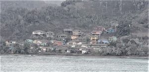
Photo : IPR
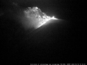
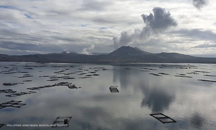
Philippines , Taal :
TAAL VOLCANO BULLETIN 02 February 2020 8:00 A.M.
Activity in the Main Crater in the past 24 hours has been characterized by weak emission of white steam-laden plumes 50 to 100 meters tall that drifted southwest. Sulfur dioxide (SO2) emission was measured at an average of 97 tonnes/day. The Taal Volcano Network recorded one hundred fifty-three (153) volcanic earthquakes including two (2) low-frequency events. These earthquakes signify magmatic activity beneath the Taal edifice that could lead to eruptive activity at the Main Crater.
Alert Level 3 is maintained over Taal Volcano. DOST-PHIVOLCS reminds the public that sudden steam-driven and even weak phreatomagmatic explosions, volcanic earthquakes, ashfall, and lethal volcanic gas expulsions can still occur and threaten areas within Taal Volcano Island and nearby lakeshores. DOST-PHIVOLCS recommends that entry into the Taal Volcano Island as well as into areas over Taal Lake and communities west of the island within a seven (7) km radius from the Main Crater must be strictly prohibited. Local government units are advised to assess areas outside the seven-kilometer radius for damages and road accessibilities and to strengthen preparedness, contingency and communication measures in case of renewed unrest. People are also advised to observe precautions due to ground displacement across fissures, frequent ashfall and minor earthquakes. Communities beside active river channels particularly where ash from the main eruption phase has been thickly deposited should increase vigilance when there is heavy and prolonged rainfall since the ash can be washed away and form lahars along the channels. Civil aviation authorities must advise pilots to avoid flying close to the volcano as airborne ash and ballistic fragments from sudden explosions and wind-remobilized ash may pose hazards to aircraft.
DOST-PHIVOLCS is closely monitoring Taal Volcano’s activity and any new significant development will be immediately communicated to all stakeholders.
Source : Phivolcs.
Photo : CNNPH , marcello Teofilo
Indonesia , Semeru :
VOLCANO OBSERVATORY NOTICE FOR AVIATION – VONA.
Issued: February 02 , 2020 .
Volcano: Semeru (263300)
Current Aviation Colour Code: ORANGE
Previous Aviation Colour Code: orange
Source: Semeru Volcano Observatory
Notice Number: 2020SMR12
Volcano Location: S 08 deg 06 min 29 sec E 112 deg 55 min 12 sec
Area: East java, Indonesia
Summit Elevation: 11763 FT (3676 M)
Volcanic Activity Summary:
Eruption with volcanic ash cloud at 22h56 UTC (05h56 local).
Volcanic Cloud Height:
Best estimate of ash-cloud top is around 13363 FT (4176 M) above sea level, may be higher than what can be observed clearly. Source of height data: ground observer.
Other Volcanic Cloud Information:
Ash cloud moving to north
Remarks:
Seismic activity is characterized by eruption, avalanche and gas emission earthquakes

INFORMATION ON THE SEMERU ERUPTION:
There was an eruption of G. Semeru, East Java on February 02, 2020 at 05:56 WIB with an ash column height of ± 500 m above the peak (± 4.176 m above sea level ). The plume column was white – gray, thick, facing north. This eruption was recorded on a seismogram with a maximum amplitude of 23 mm and a duration of ± 2 minutes 10 seconds.
CONCLUSION:
Currently, the Semeru is at level II (WASPADA).
RECOMMENDATIONS:
1. The community must not carry out activities within a radius of 1 km and in the zone up to 4 km in the sector of the South-South-East slopes of the active crater which is the active zone of the opening of the crater of G. Semeru (Jongring Seloko) as a channel for the descent of hot clouds.
2. Be aware of the presence of the lava dome in the Seloko Jongring crater.
Source : Magma Indonésia , PVMBG .
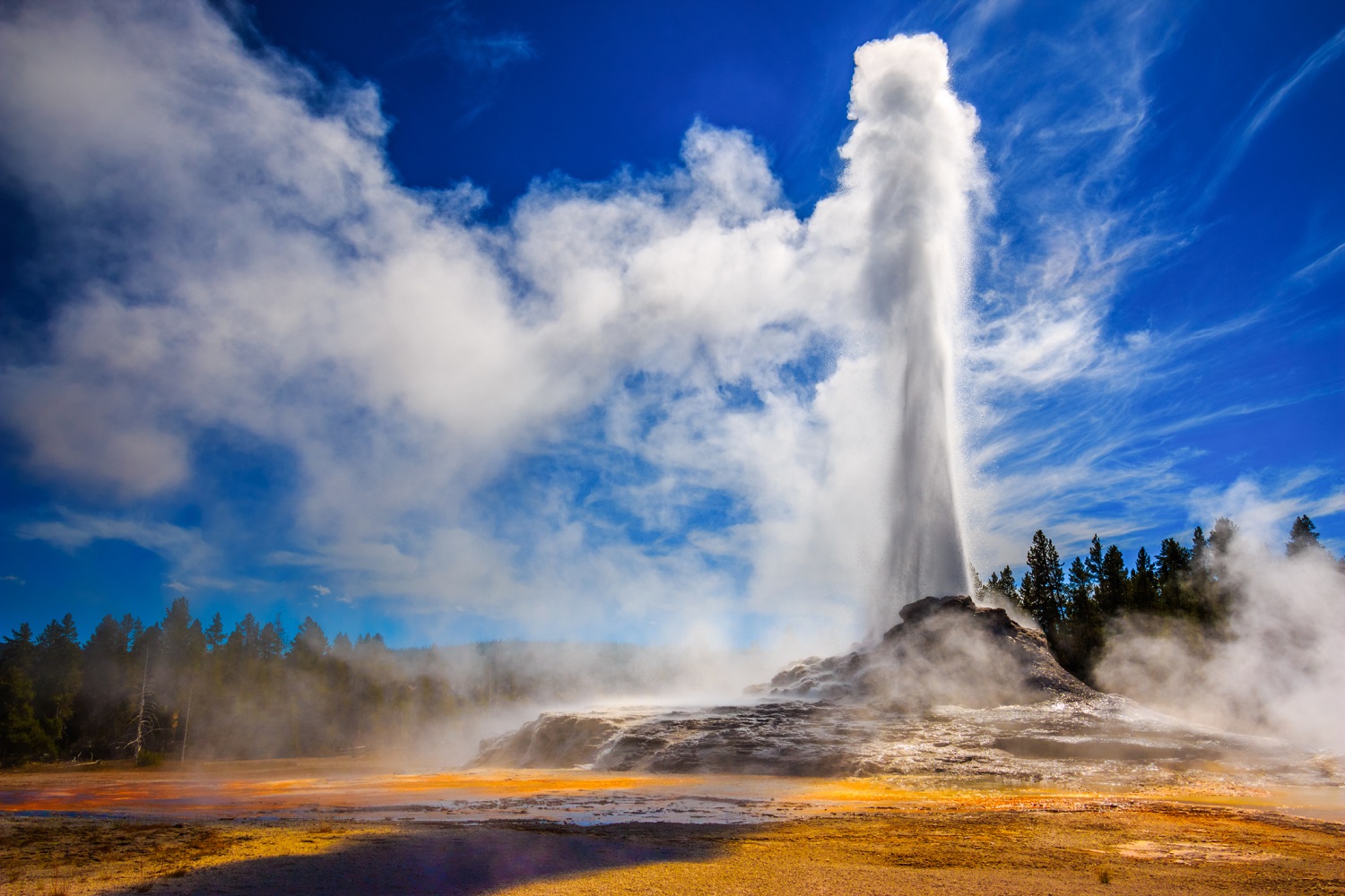
United-States , Yellowstone :
44°25’48 » N 110°40’12 » W,
Summit Elevation 9203 ft (2805 m)
Current Volcano Alert Level: NORMAL
Current Aviation Color Code: GREEN
Recent work and news
Steamboat geyser, in Norris Geyser Basin, experienced two water eruptions in the past month, on January 9 and 23.
Seismicity
During January 2020, the University of Utah Seismograph Stations, responsible for the operation and analysis of the Yellowstone Seismic Network, located 41 earthquakes in the Yellowstone National Park region. The largest event was a micro earthquake of magnitude 2.8 located 12 miles north of Pahaska Tepee, WY, on January 10 at 3:57 AM MST.
No swarm activity was observed in January.
Yellowstone earthquake activity remains at background levels.
Ground deformation
Subsidence is clearly indicated by GPS stations throughout Yellowstone National Park. Yellowstone caldera subsidence has been ongoing since 2015, occurring at an average rate of 2-3 cm (about 1 in) per year with minor fluctuations related to seasonal changes. In the area of Norris Geyser Basin, GPS data indicated the start of subsidence in September 2019; since that time, the area has subsided by about 3 cm (a little over 1 in).
Source : YVO.
Photo : Parc National