April 13 , 2021 .
Saint Vincent , Soufrière Saint Vincent :
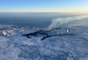
Dome collapse and pyroclastic flows along the valleys on the eastern and western coast at approximately 4h15am.
The volcano continues to erupt explosively and has now begun to generate pyroclastic density currents. Explosions and accompanying ashfall, of similar or larger magnitude, are likely to continue to occur over the next few days
La Soufriere SCIENTIFIC UPDATE – 12/04/21 6:00AM
– Explosions with pyroclastic density currents at La Soufriere.
– Since midday on April 11, the time between episodes of high-amplitude tremor has lengthened from 1.5-4 hours to 5-8 hours.
– The episodes continue to coincide with periods of enhanced venting or explosive activity.
– Small volcano-tectonic earthquakes were recorded starting at about 6:00pm on 11 April.
– At about 4:15 am observations from the Belmont Observatory indicated that pyroclastic density currents (PDC) entered multiple valleys surrounding the volcano.
– Pyroclastic density currents are hot (200°C-700°C), ground-hugging flows of ash and debris.
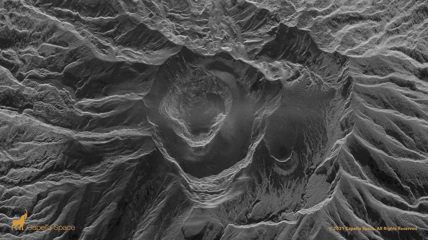
– Analysis of satellite imagery and comparison with previous images indicate that the explosive eruptions thus far have destroyed the pre-existing domes (1979 and 2020-21)
– The current explosions are being generated from a new vent.
– The volcano continues to erupt explosively and has now begun to generate pyroclastic density currents.
-Explosions and accompanying ashfall, of similar or larger magnitude, are likely to continue to occur over the next few days.
La Soufriere SCIENTIFIC UPDATE – 12/04/21 6:00PM
– The pattern of seismic activity changed again, with the end of the episodes of high-amplitude tremor 2-8 hours apart.
– Three episodes of tremor have been recorded since 6am, two of them lower-amplitude and the third, at about 5pm, was high- amplitude.
– The episodes continue to coincide with periods of enhanced venting or explosive activity
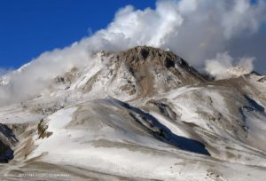
– A reconnaissance of the entire north coast of St. Vincent from Chateaubelair to Georgetown with assistance from the Coast Guard.
– Observations made indicate that pyroclastic density currents (PDCs) had descended several valleys on the southern and western flanks of the volcano and had reached the sea at Morne Ronde, Larikai and Trois Loupes Bay.
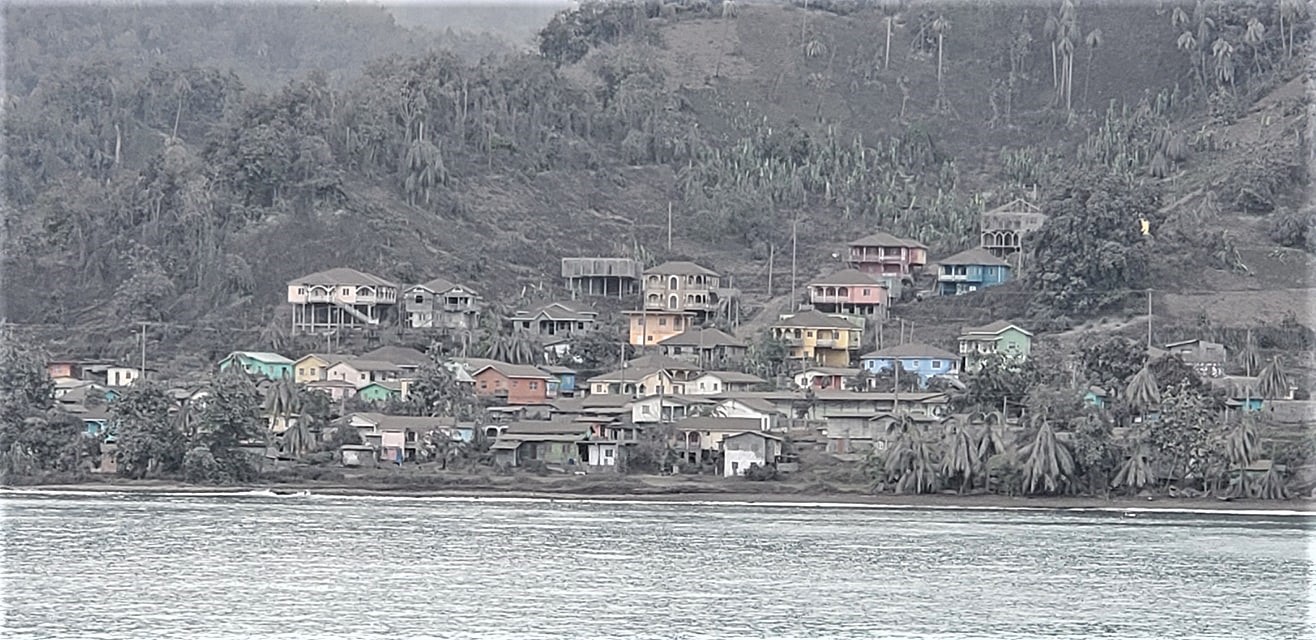
– Extensive damage to vegetation was noted in an area extending from Larikai Bay to Turner Bay on the west coast.
– No other areas along the coast had been affected by PDCs but villages located on the eastern flank of the volcano had been affected by heavy ashfall.
– Explosions and accompanying ashfall, of similar or larger magnitude, are likely to continue to occur over the next few days with the chance of PDCs occurring.
Source : UWI.
Photo : Capella Space , Nemo .
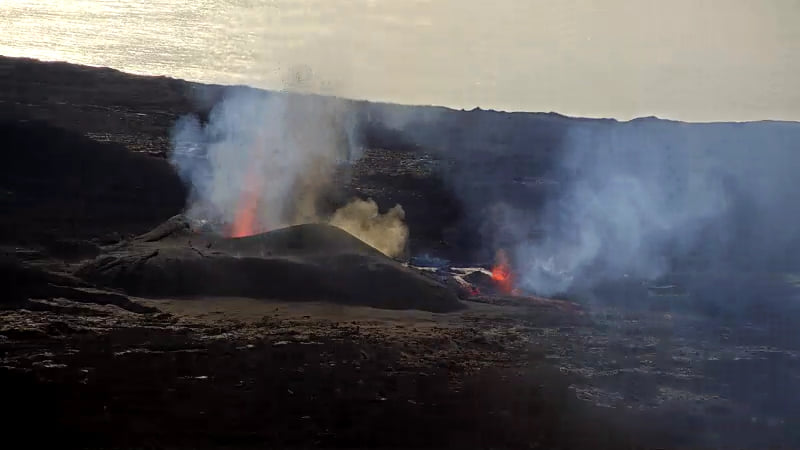
Iceland , Geldingadalur :
The eruption of Geldingadalur, April 12, 2021:
Lava flow measurements:
The latest lava flow size data is based on this afternoon’s flyby. Aerial photographs were taken from Garðaflug’s plane with the Hasselblad camera of the Institute of Natural History, and terrestrial models were made of the lava flows at Geldingadalur, Meradalur and higher on Fagradalsfjall, where find the last craters.
The results show that the total flow from all craters over the past four days has averaged nearly 5 m3 / s.
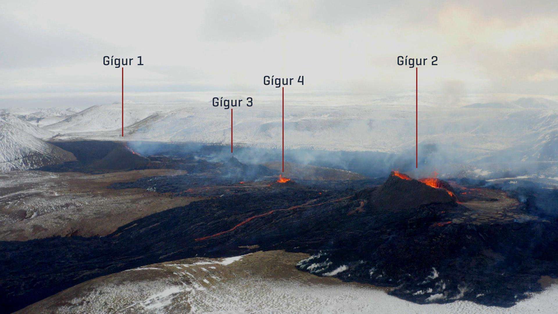
This is almost equal to the average flow since the start of the eruption. It appears that the increase that took place last week, alongside the opening of new cracks, was rather short-lived. The area of lava has increased relatively little in recent days, as the recently formed magma mostly started to increase the thickness of the lava. The total volume is now just over 10 million cubic meters.
Source et photo : RUV.
La Réunion , Piton de la Fournaise :
Press release of 04/13/2021 – 6:45 a.m.
The eruption that began on 04/09/2021 at 7 p.m. (appearance of the tremor) continues. The intensity of the volcanic tremor (indicator of the intensity of the eruption) over the last 24 hours has been very fluctuating.
These fluctuations can be linked either to:
– the cone under construction which undergoes construction and dismantling phases, thus influencing the speed of the lava flows at the level of the vent;
– or to punctual releases of pockets of gas trapped in the supply ducts which can be released suddenly causing an increase in the tremor with a certain periodicity.
Shot of the eruptive site during the day of 04/12/2021 at 8:42 a.m. local time from the OVPF-IPGP-IRT webcam (© OVPF-IPGP-IRT).
Over the last 24 hours, 31 superficial volcano-tectonic earthquakes (between sea level and the surface) have been recorded under the summit craters.
Observations of the eruptive site always show two eruptive mouths, a main and a secondary of lower activity slightly downstream. The height of the lava fountains
emitted by the main mouth fluctuates between 20 and 60 meters depending on the periods of activity.
Yesterday evening, the flow front was located in the Piton le Bonnet sector at around 1500-1550m altitude, the flow had thus traveled about 3.6 km since the start of the eruption.
The plume of gas directed towards the South and the West made it possible to record for the day yesterday SO2 flows of between 4 and 5 ktonnes / day on the NOVAC stations of the OVPF-IPGP located on the periphery of Enclosure, while flows of the order of 2-4 ktonnes / day were recorded between April 9 and 11.
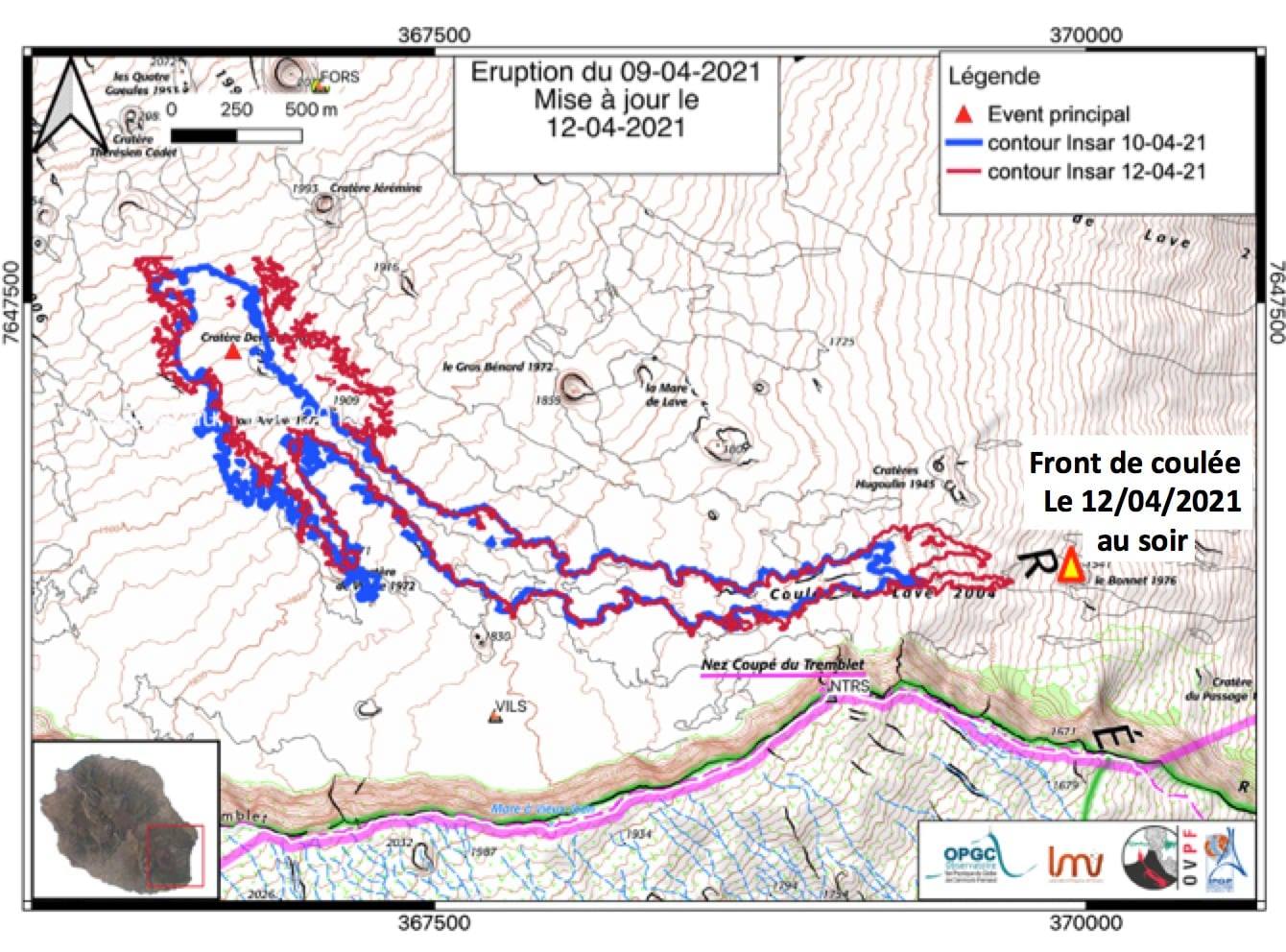
Evolution of the contours of the lava flow on April 11 (in blue) and 12 (in red) April 2021 deduced from satellite data (INSAR consistency data) and location point of the flow front on April 12, 2021 at the end of the day (yellow triangle) (© LMV-OPGC-OVPF-IPGP).
If the magmas involved are still non-degassed magmas, these flows could correspond to lava flows of the order of 24-30 m3 / s; in the case of degassed magmas, these flows could correspond to larger flows of the order of 45-55 m3 / s.
The surface flows estimated from satellite data via the HOTVOLC platform (OPGC – Clermont Auvergne University) remain very disturbed by the cloud cover on the eruptive site with values between 8 and 30 m3 / s since the start of the eruption .
Alert level: Alert 2-2
Source : OVPF.
Read the article : https://www.ipgp.fr/sites/default/files/ovpf_20210413_6h45_communique_eruption.pdf
Photos : OVPF.
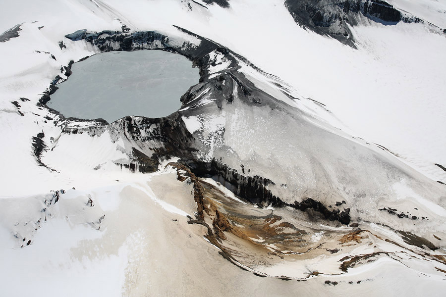
New Zealand , Ruapehu :
Mt Ruapehu status update: volcanic activity remains at low level, Crater Lake (Te Wai ā-moe) at 40°C
Published: Tue Apr 13 2021 10:45 AM
Volcanic Alert Level remains at 1
Aviation Colour Code remains at Green
Following the period of heightened activity in December 2020, volcanic activity at Mt Ruapehu has since remained at low level over the last three months, with gas emissions, lake chemistry and volcanic tremor all within typical ranges. After a temporary cooling period, the Crater Lake (Te Wai ā-moe) temperature is now back to around 40 °C. The Volcanic Alert Level at Mt Ruapehu remains at Level 1.

In December 2020, we observed elevated unrest at Mt Ruapehu, with increased gas emissions, volcanic tremor and high lake temperatures of 43ºC. This unrest declined in January and the Volcanic Alert Level was lowered to Level 1 on 11 January 2021.
Since then we conducted two gas flights and collected lake samples twice. The results from these visits and our continuous monitoring of volcanic earthquake activity, tremor levels, and Crater Lake (Te Wai ā-moe) temperature and level indicate that key parameters remain within normal ranges. The largest observed variation has been with the crater lake water temperature. This was over 43ºC in early January 2021 then cooled to 26ºC on 15 February. It has now reheated to 40ºC. To maintain the lake water temperature at around 40ºC our modelling indicates that ~400 MW (megawatt) of heat is still entering the lake.
All these observations suggest that volcanic activity remains at low level at Mt Ruapehu.
The Volcanic Alert Level remains at Level 1 which reflects the current level of volcanic unrest. Mt Ruapehu is an active volcano and has the potential to erupt with little or no warning when in a state of volcanic unrest. The Aviation Colour Code remains at Green.
The Volcanic Alert Level should not be used to forecast future activity, however at Volcanic Alert Level 1, eruptions are less likely than at Volcanic Alert Level 2.
Volcanic Alert Level 1 indicates the primary hazards are those expected during volcanic unrest: steam discharge, volcanic gas, earthquakes, landslides and hydrothermal activity. While Volcanic Alert Level 1 is mostly associated with environmental hazards, eruptions can still occur with little or no warning.
Source : Geonet / Yannik Behr / Volcanologue de service.
Photos : Bradd Scott , Photovolcanica.
Guatemala , Pacaya :
Activity:
OVPAC observers report that the volcano maintains a high level of lava effusion from the fissure on the southwest flank, feeding the lava flow which is approximately 3,700 meters in length. Greater activity was observed on the southern and western flanks, in the region of La Breña and La Finca Campo Alegre, burning coffee and avocado plantations and other types of vegetation. The ashes reach heights of around 3,500 meters above sea level (11,482 feet) which disperse to the west and southwest, at a possible distance of 10 kilometers, with the possibility of ash falling on communities near the volcano.
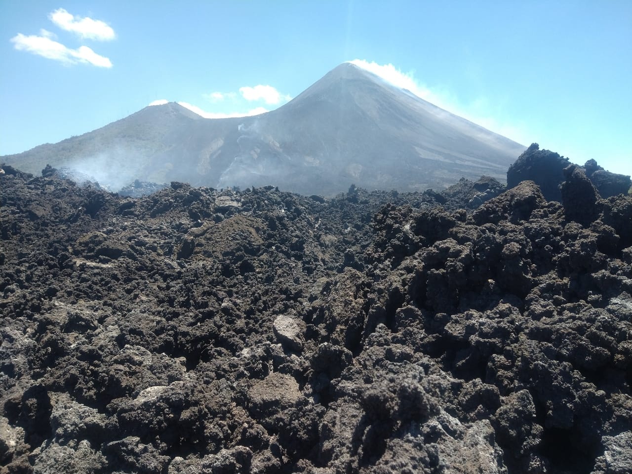
The front of the stream is 400 meters from the first houses of the village El Patrocinio and moves slowly. Another active southern front is located 250 east of the village of El Rodeo. The generation of other lava flows on the various sides of the volcano is not excluded, due to the high activity. The likelihood of new ash and magmatic gas emissions from Mackenney Crater, which could cause ash falls in communities near the volcano, is not excluded. The PCG seismic station records a tremor (internal vibration) associated with the rise of magma and the displacement of the lava flow.
Source : Insivumeh .
Photo : San Vincente Pacaya.