October 20 , 2019.
Hawaii , Mauna Loa :
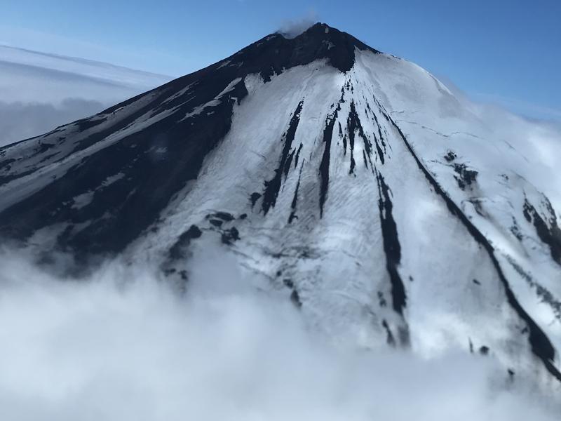
19°28’30 » N 155°36’29 » W,
Summit Elevation 13681 ft (4170 m)
Current Volcano Alert Level: ADVISORY
Current Aviation Color Code: YELLOW
Activity Summary:
Mauna Loa Volcano is not erupting. Rates of deformation and seismicity have not changed significantly over the past week and remain above long-term background levels.
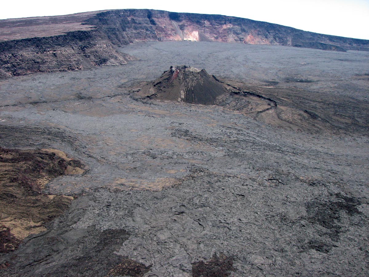
An aerial view of the 1940 ash cone on the floor of the Mauna Loa caldera, facing southeast. The wall of the caldera at the bottom is about 170 m (560 Ft).
Observations:
During the past week, approximately 85 small-magnitude earthquakes (nearly all smaller than M2.2) were detected beneath the upper elevations of Mauna Loa. Most of the earthquakes occurred at shallow depths of less than 5 km (~3 miles) below ground level.
Global Positioning System (GPS) and Interferometric Synthetic Aperture Radar (InSAR) measurements show continued summit inflation, consistent with magma supply to the volcano’s shallow storage system.
Readings of fumarole temperature and gas concentrations at the Sulphur Cone monitoring site on the Southwest Rift Zone remain stable.
Source : HVO
Indonesia , Merapi :
ACTIVITY REPORT OF MONT MERAPI. October 11-17, 2019
RESULTS OF OBSERVATION
Visual:
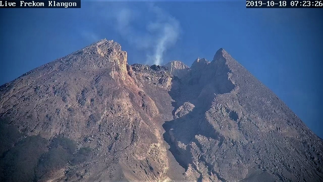
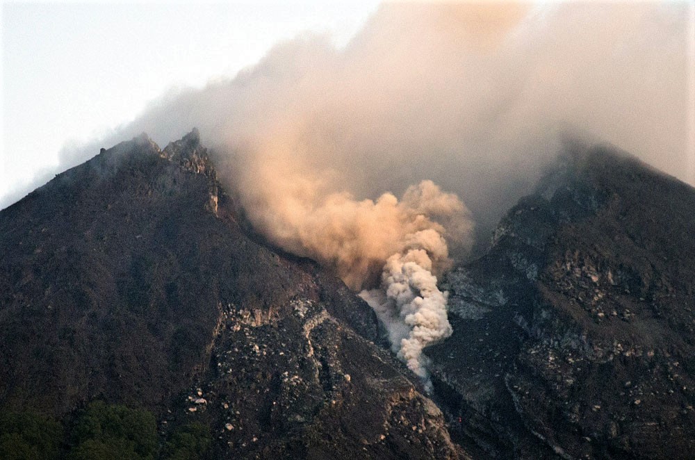
The weather around Mount Merapi is usually sunny in the morning while the evening and night are cloudy and foggy. There is a white smoke, thin to thick, with low pressure. A maximum smoke height of 500 m was observed from the observation post at Mount Merapi in Selo on 17 October 2019 at 17h20 hours.
On October 14, 2019, at 16:31, Indonesia time, a 270-second eruption with a smoke column was observed at ± 3,000 m. Eruption clouds slid for about 2 km in K. Gendol. Light ash rains were reported around Mount Merapi, mainly to the west, 25 km from the summit.
The volume of the lava dome based on analysis of aerial photos with drones dated October 16, 2019 amounted to 397,000 m3. The 14 October eruption partially dismantled the lava dome, which now forms a hemisphere in the North-East-South-West direction and is 100 meters long by 30 meters wide by 20 meters high. The crater cliffs have not undergone significant changes because of the eruptions that occurred.
Seismicity:
This week the seismicity of Mount Merapi recorded:
1 earthquake of eruption.
2 hot Avalanche earthquakes (AP),
10 emission earthquakes (DG),
2 deep volcanic earthquake (VTA),
4 shallow volcanic earthquakes (VTB),
20 multiple phase earthquakes (MP),
63 avalanche earthquakes (RF),
6 low frequency earthquakes (FL)
8 tectonic earthquakes (TT).
The internal seismicity of G. Merapi (VTA, VTB and LF) was relatively similar to that of last week and showed no indication of changes related to the October 14 eruption.
Deformation:
The deformation of G. Merapi, monitored by EDM and GPS this week, showed no significant change.
Rain and lahars:
This week, no rain or lahar was reported, nor was there any additional flow in the rivers flowing out of Mount Merapi.
Conclusion:
Based on the results of the visual and instrumental observations, it was concluded that:
1. The lava dome is currently in a stable state with relatively low growth rates.
2. The volcanic activity of Mount Merapi is still quite high and is determined by the level of activity « WASPADA ».
Source : BPPTKG.
Photo : Live Frekom Klangon 18.10.2019 / 7h23 via Bernard Duyck . Jakartapost .
Mexico , Colima :
Weekly technical bulletin of activity of the Colima volcano . Date: October 18, 2019.
Seismic activity:
Last week, 8 high frequency events (HF), 1 long period type event (LP), 2 landslides and 3.6 minutes of low amplitude tremors were automatically recorded.
Visual observations:
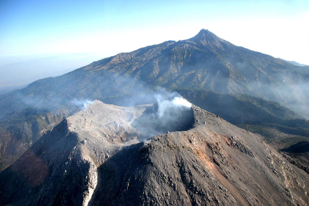
Intermittent steam and gas emissions from the northeast side of the crater continue to be recorded during the reporting period, but fumaroles were also observed in the western portion. The fixed thermal camera located to the south of the volcano recorded no thermal anomaly during this week.
Geochemistry:
The flow of SO2 was not measured during the week.
Remote perception:
No thermal anomalies detected by the MIROVA satellite system were observed during the last week.
Diagnostic:
The volcano maintains an explosive activity of low intensity. The occurrence of these events indicates that the gas probably associated with the moving magma has reached surface levels. This activity can continue and increase in intensity over the following days, weeks or months. The staff in charge of monitoring the volcano monitors any changes and developments in the activity.
Possible scenarios from days to weeks:
1. Low to moderate explosions continue.
2. There is a new growth of lava dome in the crater with collapses of glowing material and lava flows.
Source : RESCO-CUEV-Facultad de Ciencias Universidad de Colima .
Photo : proceso.com.mx.
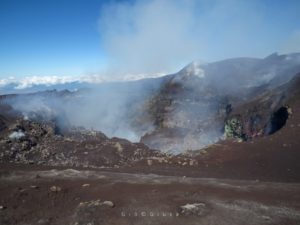
Italy / Sicily , Etna :
COMMUNICATION on the volcanic activity of October 19, 2019, 06:52:47 (UTC) – ETNA.
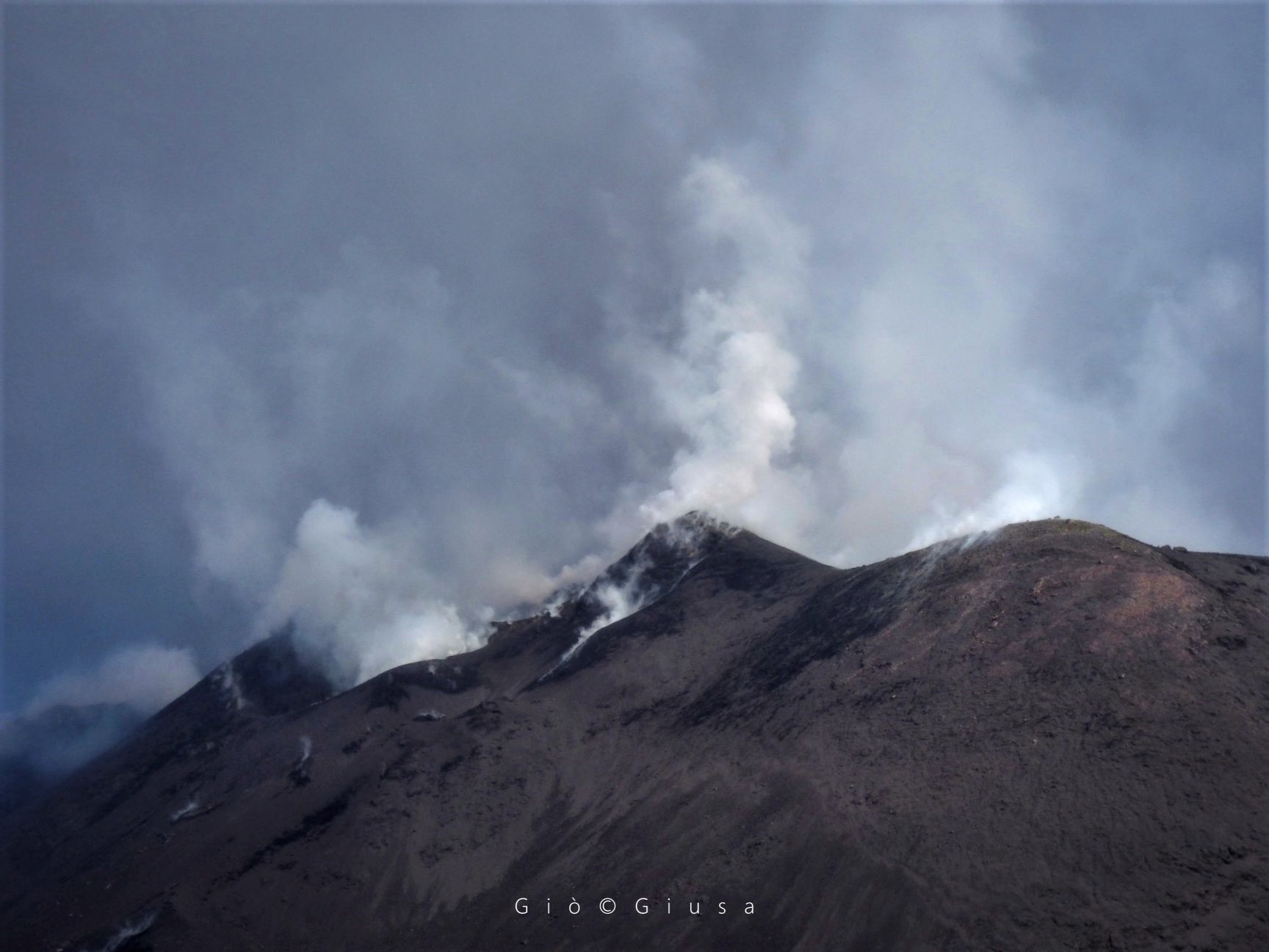
The National Institute of Geophysics and Volcanology, Osservatorio Etneo, announced that from around 06:29 UTC, CCTV cameras were showing ash from the craters of the summit, especially craters from the North -East and Bocca Nuova. The average amplitude of volcanic tremor has remained at average values, without showing any significant changes.
COMMUNICATION on the volcanic activity of October 19, 2019, 10:33:50 (UTC) – ETNA.
The Osservatorio Etneo, National Institute of Geophysics and Volcanology, reports that from 10:27 UTC, CCTV cameras show a significant decrease in ash emissions from the craters of the summit, especially craters of the Voragine and Northeast. The average amplitude of volcanic tremor has remained at average values, without showing any significant changes.
VOLCANO OBSERVATORY NOTICE FOR AVIATION (VONA)
Issued: October 19 ,2019
Volcano: Etna 211060
Current Color Code: ORANGE
Previous Color Code: red
Source: Etna Volcano Observatory
Notice Number: 2019/0090/06F08
Volcano Location: 3744N 01500E
Area: Italy
Summit Elevation: 3300 m
Volcanic Activity Summary:
EXPLOSIVE ACTIVITY IS STILL OBSERVED AT SUMMIT CRATERS; WEAK ASH EMISSION ONGOING
Remarks:
THE PHENOMENON IS OBSERVED BY VIDEOSURVEILLANCE CAMERAS AND IS RECORDED FROM 1041Z *24/7 OE CONTROL ROOM OPERATOR
Source : INGV.
Photo : Gio Giusa .
Alaska , Pavlof :
AVO/USGS Volcanic Activity Notice
Current Volcano Alert Level: ADVISORY
Previous Volcano Alert Level: NORMAL
Current Aviation Color Code: YELLOW
Previous Aviation Color Code: GREEN
Issued: Saturday, October 19, 2019, 2:07 PM AKDT
Source: Alaska Volcano Observatory
Location: N 55 deg 25 min W 161 deg 53 min
Elevation: 8261 ft (2518 m)
Area: Alaska Peninsula
Volcanic Activity Summary:
Small explosion signals from Pavlof have been detected on the infrasound network located at Sand Point and on the local seismic network today. The volcano is currently obscured by clouds in satellite images. It is unknown if the explosions produced any volcanic ash, but their small size suggests any hazard is currently confined to the area around the volcano’s summit. Because these signals are above normal background for Pavlof, the Alaska Volcano Observatory is raising the Aviation Color Code to YELLOW and the Alert Level to ADVISORY.
Recent Observations:
[Volcanic cloud height] None
[Other volcanic cloud information] None
[Lava flow/dome] None
[Lava flow] None
Remarks:
Pavlof Volcano is a snow- and ice-covered stratovolcano located on the southwestern end of the Alaska Peninsula about 953 km (592 mi) southwest of Anchorage. The volcano is about 7 km (4.4 mi) in diameter and has active vents on the north and east sides close to the summit. With over 40 historic eruptions, it is one of the most consistently active volcanoes in the Aleutian arc. Eruptive activity is generally characterized by sporadic Strombolian lava fountaining continuing for a several-month period. Ash plumes as high as 49,000 ft ASL have been generated by past eruptions of Pavlof, and during the March 2016 eruption, ash plumes as high as 40,000 feet above sea level were generated and the ash was tracked in satellite data as distant as eastern Canada. The nearest community, Cold Bay, is located 60 km (37 miles) to the southwest of Pavlof.
Source : AVO.
Photo : Mulliken, Katherine , 21 Juillet 2018.