October 31, 2019 . EN . Italy : Stromboli , Chile : Nevados of Chillan , Mexico : Popocatepetl , Alaska : Semisopochnoi .

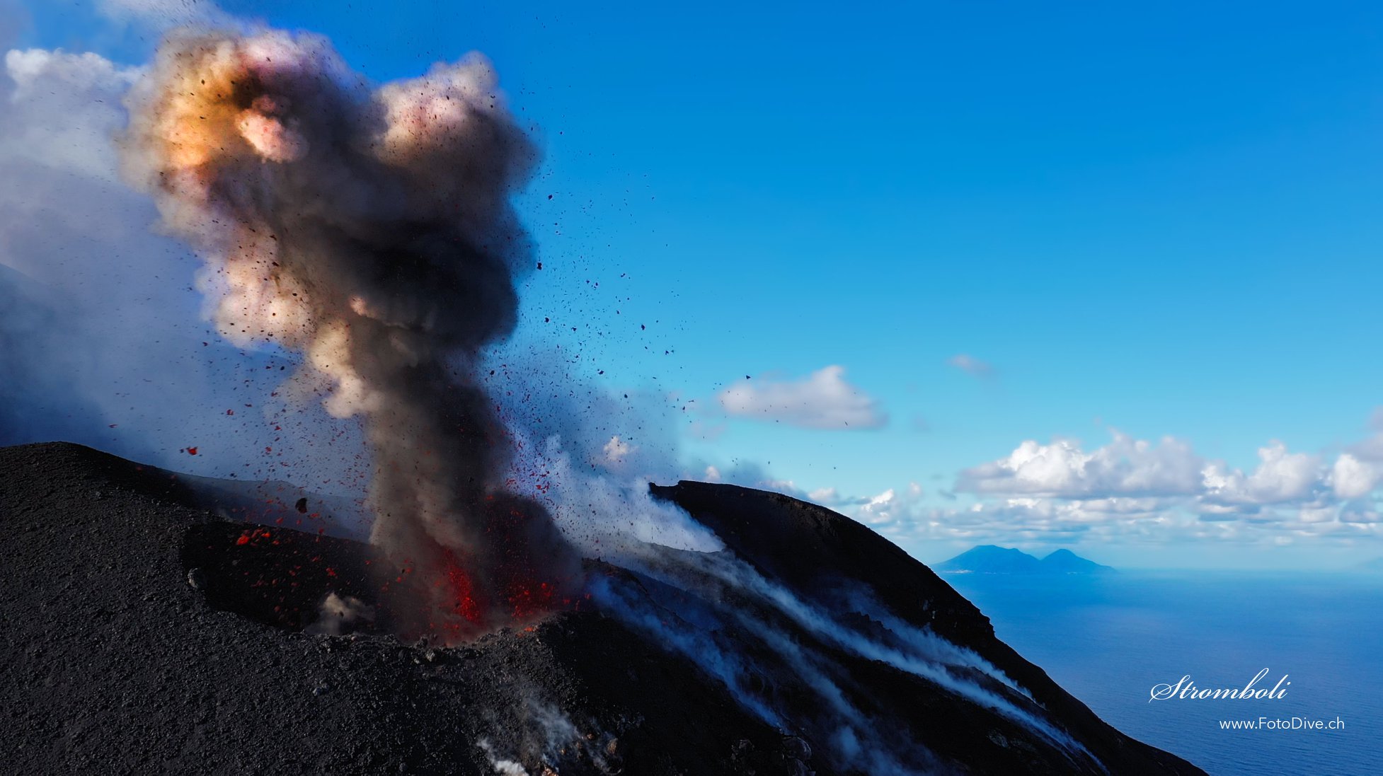
October 31 , 2019.


Italy , Stromboli :

Daily Bulletin of 30/10/2019

SUMMARY OF ACTIVITY STATUS

In light of the surveillance data, we highlight:
1) VOLCANOLOGICAL OBSERVATIONS: Normal explosive activity of Strombolian type accompanied by degassing activities.
2) SISMOLOGY: The level of volcanic tremor generally shows medium-high values ​​with some oscillations on high values. The magnitude of the earthquakes of explosions remained between average / low and medium / high with some events of high amplitude. Please note the occurrence of rare hybrid events.
3) DEFORMATIONS: The deformation monitoring networks of the island did not show any significant variation in communication during the last 24 hours.
4) GEOCHEMISTRY: The flow of SO2 is at an average level. There is no measure of CO2 / SO2 ratio available. The last value for the day of 27/10/2019 was at low levels. The isotopic ratios of helium dissolved in the thermal layer remain unchanged for the mean-low values ​​(data of 23/10/2019).

VOLCANOLOGICAL OBSERVATIONS.
The analysis of the images of surveillance cameras at 400 m altitude (SQV and SQT) and Punta dei Corvi (SCPT), updated at 09:00 UTC on 30/10/2019, highlighted an ordinary Strombolian activity with the most active mouths in the North and South-Central craters. The total daily time frequency was 22 events / h (high frequency). In detail in the North zone, the explosive activity was 7 to 8 events / h of low intensity (less than 80 m high) and medium (less than 150 m high) explosions emitting coarse materials (lapilli and bombs) that sometimes covered the slopes of the cone facing the Sciara del Fuoco. In the Center-South zone, an average explosion frequency of 15 to 16 events / h (ash mixed with coarse material) of medium intensity (less than 150 m in height) and sporadically high (the products reached 250 m ) has been observed. The raw products also fell in the direction of the Sciara del Fuoco.

The level of volcanic tremort remained at medium to high values, with peaks at high values.

Source : INGV.

Read the full article : file:///C:/Users/Utilisateur/AppData/Local/Packages/Microsoft.MicrosoftEdge_8wekyb3d8bbwe/TempState/Downloads/BollettinoGiornalieroStromboli20191030%20(1).pdf

Photo : Willie FotoDive


Chile , Nevados of Chillan :

Volcanological Special Report (REAV) Régie de Ñuble, Nevados de Chillán Volcanic Complex, October 29, 2019, 03:50 local time (mainland Chile)

The National Geological and Mining Service of Chile (Sernageomin) discloses the following PRELIMINARY information obtained from the monitoring equipment of the National Volcanic Monitoring Network (NVRN) processed and analyzed at the Volcanological Observatory of the Southern Andes ( OVDAS)

On Tuesday, October 29 at 3:27 am local time (06h27 UTC), the control stations installed near the Nevados Volcanic Complex of Chillán recorded a volcano-tectonic event of local magnitude 3.2.

The characteristics of the earthquake are as follows:
TIME OF ORIGIN: 03:27 local time (06:27 UTC)
LATITUDE: 36 883 ° S
LONGITUDE: 71.347 ° W
DEPTH: 4.07 km
LOCAL MAGNITUDE: 3.2.

OBSERVATIONS:
The volcanic technical alert is maintained at the level: ORANGE.

Other remarks:
– The network of GNSS stations installed on the volcanic complex recorded a maximum increase in the length of the control lines crossing the active crater of 3.8 ± 0.1 cm.
– The elongation rate of the last 30 days is 0.7 ± 0.06 cm / month. During this period, the lengthening continues in all monitoring stations. The vertical lift rate for the last 30 days is 1.4 ± 0.3 cm / month, at the closest station to the active crater (1.5 km).
– The MIROVA group did not report any thermal anomalies.
– Infrasound sensors recorded explosion-related signals (EX), with peak values of 27.2 Pa reduced to 1 km.

Sernageomin monitors online and informs in a timely manner of possible changes in volcanic activity.

Source : Sernageomin.

Photo : Nicolas Luengo.


Mexico , Popocatepetl :

October 30, 11:00 am (October 30, 17:00 GMT)

According to the monitoring systems of the Popocatepetl volcano, 267 exhalations have been identified. Due to the nebulosity of the area, there was no visibility for most of the period covered by this report; it has sometimes been verified that they are accompanied by steam and gas. Similarly, 188 minutes of tremor have been identified.

At the time of writing, there was no visibility due to weather conditions. However, it was possible in previous hours to distinguish an emission of water vapor and volcanic gas dispersing in the direction of the Southwest.

CENAPRED urges NOT to approach the volcano and in particular the crater because of the risk of falling ballistic fragments, and in case of heavy rains to stay away from the bottom of the ravines due to the risk of mudslides and debris.

The warning light of Popocatépetl is in YELLOW PHASE 2.

Source : Cenapred.

Photo : Archives webcam


Alaska , Semisopochnoi :

51°55’44 » N 179°35’52 » E,
Summit Elevation 2625 ft (800 m)
Current Volcano Alert Level: ADVISORY
Current Aviation Color Code: YELLOW

Semisopochnoi, view of Anvil Peak from the southwest. Image courtesy of Ian L. Jones, Department of Biology, Memorial University.

Seismic activity has increased at Semisopochnoi over the past day with continuous tremor observed on local seismic stations beginning this morning. No eruptive activity has been detected by regional infrasound data, and no anomalous activity was observed in satellite data in the past 24 hours.

Semisopochnoi is monitored with an on-island seismic network and remotely by satellite and lightning sensors. An infrasound array on Adak Island may detect explosive emissions from Semisopochnoi with a slight delay (approximately 13 minutes) if atmospheric conditions permit.

Source : AVO.

Photo : Jones, I. L. 30 Juin 2004.

31 Octobre 2019. FR. Italie : Stromboli , Chili : Nevados de Chillan , Mexique : Popocatepetl , Alaska : Semisopochnoi .

31 Octobre 2019.


Italie , Stromboli :

Bulletin quotidien du 30/10/2019

SOMMAIRE DU STATUT D’ACTIVITÉ
À la lumière des données de surveillance, nous soulignons:

1) OBSERVATIONS VOLCANOLOGIQUES: Activité explosive normale de type strombolienne accompagnée d’activités de dégazage.
2) SISMOLOGIE: Le niveau du tremor volcanique montre généralement des valeurs moyennes-élevées avec quelques oscillations sur les valeurs élevées. L’ampleur des séismes d’explosions est restée comprise entre moyenne / basse et moyenne / haute avec quelques événements de forte amplitude. Veuillez noter l’occurrence de rares événements hybrides  .
3) DÉFORMATIONS: Les réseaux de surveillance des déformations de l’île n’ont pas montré de variation significative à communiquer au cours des 24 dernières heures.
4) GEOCHIMIE: Le flux de SO2 est à un niveau moyen. Il n’y a pas de mesure de ratio CO2 / SO2 disponible. La dernière valeur pour la journée du 27/10/2019 était à des niveaux bas. Les rapports isotopiques de l’hélium dissous dans la couche thermique restent inchangés pour les valeurs moyennes-basses (données du 23/10/2019).

OBSERVATIONS VOLCANOLOGIQUES.
L’analyse des images des caméras de surveillance à 400 m d’altitude (SQV et SQT) et Punta dei Corvi (SCPT), mise à jour à 09h00 UTC le 30/10/2019, ont mis en évidence une activité strombolienne ordinaire avec les bouches les plus actives dans les cratères Nord et Centre-Sud. La fréquence horaire quotidienne totale  était de 22 événements / h (haute fréquence). En détail dans la zone Nord, l’activité explosive était de 7 à 8 événements / h d’explosions de faible intensité (moins de 80 m de hauteur) et moyennes (moins de 150 m de hauteur) émettant des matériaux grossiers (lapilli et bombes) qui couvraient parfois les pentes du cône face à la Sciara del fuoco. Dans la zone Centre-Sud , une fréquence moyenne d’explosions de 15 à 16 événements / h (cendres  mélangées à des matériaux grossiers ) d’ intensité moyenne (moins de 150 m de hauteur) et sporadiquement élevée (les produits ont atteint 250 m) a été observée  . Les produits bruts sont également retombés dans la direction de la Sciara del fuoco.

Le niveau de tremort volcanique est resté à des valeurs moyennes à élevées, avec des pics sur des valeurs élevées.

Source : INGV.

Lire l’article en entier : file:///C:/Users/Utilisateur/AppData/Local/Packages/Microsoft.MicrosoftEdge_8wekyb3d8bbwe/TempState/Downloads/BollettinoGiornalieroStromboli20191030%20(1).pdf

Photo : Willie FotoDive


Chili , Nevados de Chillan :

Rapport spécial volcanologique (REAV) Régie de Ñuble, Complexe volcanique Nevados de Chillán  , 29 octobre 2019, 03h50 Heure locale (Chili continental)

Le Service national de géologie et des mines du Chili (Sernageomin) divulgue les informations PRELIMINAIRES suivantes, obtenues grâce à l’équipement de surveillance du Réseau national de surveillance volcanique (RNVV), traitées et analysées à l’observatoire volcanologique des Andes du Sud (OVDAS):

Le mardi 29 octobre à 03h27 heure locale (06h27 UTC), les stations de contrôle installées à proximité du Complexe volcanique  Nevados de Chillán ont enregistré un événement volcano-tectonique de magnitude locale 3.2.

Les caractéristiques du séisme sont les suivantes:
HEURE D’ORIGINE: 03h27 heure locale (06:27 UTC)
LATITUDE: 36 883 ° S
LONGITUDE: 71.347 ° W
PROFONDEUR: 4.07 km
MAGNITUDE LOCALE: 3,2.

OBSERVATIONS:
L’alerte technique volcanique est maintenue au niveau : ORANGE.

Autres remarques :
– Le réseau de stations GNSS installées sur le complexe volcanique a enregistré une augmentation maximale de la longueur des lignes de contrôle traversant le cratère actif de 3,8 ± 0,1 cm.
– Le taux d’allongement des 30 derniers jours est de 0,7 ± 0,06 cm / mois. Pendant cette période, l’ allongement continue dans toutes les stations de surveillance. Le taux de portance vertical des 30 derniers jours est de 1,4 ± 0,3 cm / mois, à la station la plus proche du cratère actif (à 1,5 km).
– Le groupe MIROVA n’a pas signalé d’anomalies thermiques.
– Les capteurs d’infrasons ont enregistré des signaux associés aux explosions (EX), avec des valeurs maximales de 27,2 Pa réduits à 1 km.

Le Sernageomin effectue une surveillance en ligne et informe en temps utile de possibles changements dans l’activité volcanique  .

Source : Sernageomin.

Photo : Nicolas Luengo.


Mexique , Popocatepetl :

30 octobre, 11h00 (30 octobre, 17h00 GMT)

Grâce aux systèmes de surveillance du volcan Popocatepetl, 267 exhalations ont été identifiées. En raison de la nébulosité de la zone, il n’existait aucune visibilité pendant la majeure partie de la période couverte par le présent rapport; il a parfois été vérifié qu’elles étaient accompagnées de vapeur d’eau et de gaz . De même, 188 minutes de tremor ont été identifiées.

Au moment de la rédaction de ce rapport, il n’existait aucune visibilité en raison des conditions climatiques. Cependant, il était possible au cours des heures précédentes de distinguer une émission de vapeur d’eau et de gaz volcaniques se dispersant dans la direction du Sud-Ouest  .

Le CENAPRED demande instamment de ne PAS se rapprocher du volcan et en particulier du cratère, en raison du risque de chute de fragments balistiques, et en cas de fortes pluies de rester loin du fond des ravins en raison du risque de coulées de boue et de débris.

Le feu de signalisation d’alerte du Popocatépetl est en JAUNE PHASE 2.

Source : Cenapred.

Photo : Archives webcam


Alaska , Semisopochnoi :

51 ° 55’44 « N 179 ° 35’52 » E,
Élévation du sommet : 2625 pi (800 m)
Niveau d’alerte volcanique actuel: AVIS
Code couleur de l’aviation actuel : JAUNE.

Le Semisopochnoi, vu d’Anvil Peak , vers le Sud-Ouest. Image reproduite avec l’aimable autorisation de Ian L. Jones, département de biologie, Université Memorial.

L’activité sismique a augmenté sur le Semisopochnoi au cours de la journée écoulée et des tremors continus ont été observés sur les stations sismiques locales commençant ce matin. Aucune activité éruptive n’a été détectée par les données régionales sur les infrasons et aucune activité anormale n’a été observée dans les données satellitaires au cours des 24 dernières heures.

Le Semisopochnoi est surveillé par un réseau sismique sur l’île et à distance par satellite et par des capteurs de foudre. Un réseau de capteurs infrasons sur l’île d’Adak peut détecter les émissions  explosives du Semisopochnoi avec un léger retard (environ 13 minutes) si les conditions atmosphériques le permettent.

Source : AVO.

Photo : Jones, I. L. 30 Juin 2004.