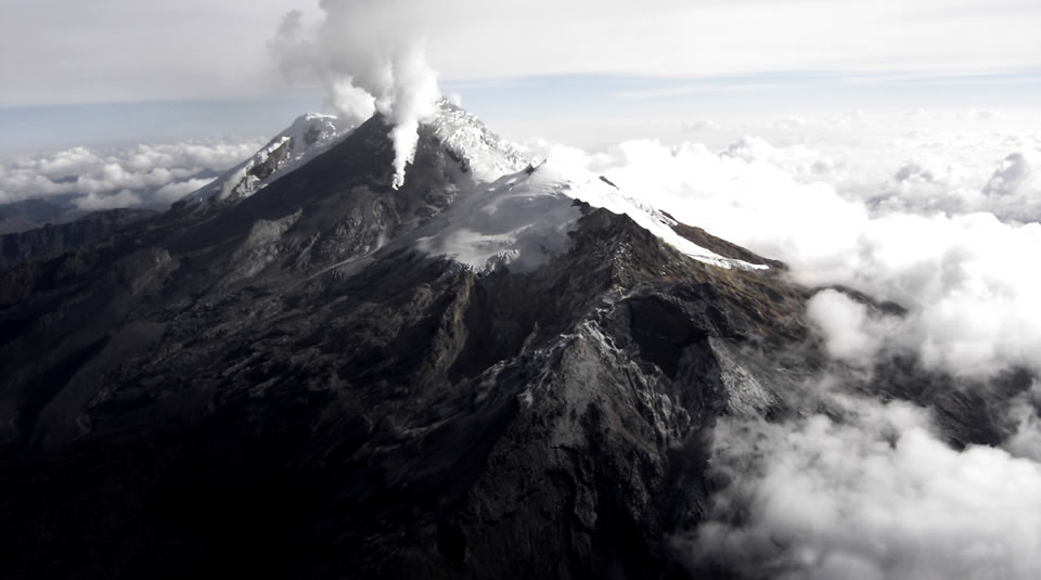
October 16, 2019. EN. Colombia : Nevado del Huila , Peru : Sabancaya , Indonesia : Karangetang , Guatemala : Fuego .

October 16 , 2019.


Colombia , Nevado del Huila :

Weekly activity bulletin of the Nevado del Huila volcano.
The level of activity of the volcano continues at the level: Activity level Yellow or (III): changes in the behavior of volcanic activity.

According to the analysis and evaluation of information obtained through the surveillance network of the Nevado del Huila volcano, during the week of October 8 to 14, 2019, the Colombian Geological Service – Volayological and Volatological Observatory of Popayán informs that :

During the evaluated period, 325 seismic events were recorded, of which 150 were related to rock fracturing processes (type VT) and 175 to fluid dynamics in volcanic conduits. Of these, 174 have been cataloged as long-period events (type LP) and one (1) as hybrid signals (type HB).

On October 11, a mobile measurement of SO2 emissions was carried out on the Nevado del Huila volcano, between the roads of Popayán and Puerto Tejada (Cauca). The gas column was detected between the populations of Popayán and Mondomo (Cauca) and the calculated flow rate was 586 t / day, which is considered low.

The images obtained during the week by the webcams of Caloto, Tafxnú, Maravillas and La Palma showed a weak degassing of the volcanic system.
 Sensors to monitor soil deformation, magnetic fields and infrasound waves have not recorded any variations associated with changes in volcanic activity.

Therefore, it is concluded that the volcano continued to exhibit stable behavior during the evaluated period. The Colombian geological service remains attentive to the evolution of the volcanic phenomenon and will inform in due time any changes that may occur.

Source : SGC.

Photo : Parque Nacional


Peru , Sabancaya :

Period of analysis: October 7 to 13, 2019. Arequipa, October 14, 2019.
Alert level: ORANGE

The Geophysical Institute of Peru (IGP) reports that the eruptive activity of the Sabancaya volcano has remained at moderate levels; that is, with the recording of continuous moderate explosions and the resulting ash and gas emission. Therefore, for the following days, no significant change in the level of activity is expected.

The analysis of records obtained from the seismic network of the Sabancaya volcano for the period from 7 to 13 October 2019 identified the occurrence of about 1983 earthquakes of volcanic origin, the highest percentage of which was associated with movements of magmatic fluids (gas and magma). During this week, an average of 36 explosions per day of average to low intensity were observed.

The monitoring of the deformation of the volcanic structure, using GNSS data (processed with fast orbits), presents no significant anomalies; nevertheless, there is still slight inflation in the northern sector of the volcano, a deformation observed since the beginning of the eruptive process. Visual surveillance, using surveillance cameras, allowed us to identify the appearance of columns of gas and ash up to 3.5 km high above the top of the volcano, which dispersed in the areas Southwest and Southeast of Sabancaya. Satellite monitoring has identified 15 volcanic anomalies on the volcano, ranging from 1 to 50 MW, associated with the presence of a hot body inside the volcano’s crater.

Source : Cenvul.

Photo : Ingemmet.


Indonesia , Karangetang :

Level of activity at Level III (SIAGA). G. Karangetang (1,784 m above sea level) has been re-erupted since November 25, 2018.

Cloudy to rainy, weak winds east and south. The temperature is about 25 to 32 ° C. The volcano is clearly visible until it is covered with fog. Smoke from the main crater is observed to be white with a low, thick intensity about 400 meters above the summit.

The seismographs, on October 15, 2019, recorded:
149 avalanche earthquakes.
15 earthquakes of explosions
1 hybrid earthquake
3 shallow volcanic earthquakes
3 distant tectonic earthquakes
Continuous tremor with an amplitude of 0.25 to 7 mm, a dominant value of 3 mm.


Recommendations:
The public and visitors / tourists are advised not to travel within 2.5 km of the main crater (South) and crater II (North), as well as in the sectoral expansion zone of Crater II. northwest 4 km and from the main crater west up to 3 km.
Communities living around rivers that originate at the summit of Mount Karangetang need to be prepared for the potential threat of lahars and sudden floods that can spread to the coast.

VONA: The latest VONA color code, Yellow, was issued on November 25, 2018 at 13:32, for volcanic ash emissions at an altitude of approximately 2,284 meters above sea level or approximately 500 meters above sea level. meters above the summit, the wind was blowing to the east.

Source : PVMBG.

Video : Streaming Planet / Marc Szeglat .


Guatemala , Fuego :

Atmospheric conditions: Cloudy
Wind: South East
Precipitation: 38.2 mm

Activity:
Presence of weak white color degassing at an approximate height of 4,300 meters above sea level (14,108 feet) dispersed in a westerly and southwesterly direction. There are 6 to 14 ash emissions with weak to moderate characteristics. The column of ash has an approximate height of 4,500 to 4,800 m altitude moving 10 to 15 km to the west and southwest.

Low to moderate rumblings are recorded, as well as low to moderate shock waves causing vibrations in the roofs and windows of homes near the volcano. Weak sounds similar to those of a locomotive with intervals of 3 to 5 minutes, associated with degassing are heard. In the evening and early morning, incandescence was observed in the crater at an approximate height of 200 to 300 meters above the crater, causing weak to moderate avalanches on the crater contour, some reaching long distances to the crater. the vegetation towards the ravines: Seca, Ceniza and Las Lajas. The ashes fall among other things in: Morelia, Santa Sofia, El Porvenir, Sangre de Cristo, San Pedro Yepocapa, Panimaché I and II.

Source : Insivumeh

Photo : Nath Duverlie

16 Octobre 2019. FR. Colombie : Nevado del Huila , Pérou : Sabancaya , Indonésie : Karangetang , Guatemala : Fuego .

16 Octobre 2019.


Colombie , Nevado del Huila :

Bulletin hebdomadaire d’activité du volcan Nevado del Huila.
Le niveau d’activité du volcan se poursuit au niveau : Niveau d’activité Jaune ou (III): changements dans le comportement de l’activité volcanique.

D’après l’analyse et l’évaluation des informations obtenues par l’intermédiaire du réseau de surveillance du volcan Nevado del Huila, pendant la semaine du 8 au 14 octobre 2019, le SERVICE GÉOLOGIQUE COLOMBIEN – Observatoire volcanologique et sismologique de Popayán informe que :

 Au cours de la période évaluée, 325 événements sismiques ont été enregistrés, dont 150 étaient liés aux processus de fracturation de roche (type VT) et 175 à la dynamique des fluides dans les conduits volcaniques. Parmi ces derniers, 174 ont été catalogués comme événements de type longue période (type LP) et un (1) comme signal hybride (type HB).

 Le 11 octobre, une mesure mobile des émissions de SO2 a été réalisée sur le volcan Nevado del Huila, entre les routes de Popayán et de Puerto Tejada (Cauca). La colonne de gaz a été détectée entre les populations de Popayán et de Mondomo (Cauca) et le débit calculé était de 586 t / jour, ce qui est considéré comme faible.

 Les images obtenues au cours de la semaine par les webcams de Caloto, Tafxnú, Maravillas et La Palma montraient un faible dégazage du système volcanique.
 Les capteurs permettant de surveiller la déformation du sol, les champs magnétiques et les ondes infrasons, n’ont pas enregistré de variations associées aux changements de l’activité volcanique.

Par conséquent, il est conclu que le volcan a continué à afficher un comportement stable pendant la période évaluée. Le service géologique colombien reste attentif à l’évolution du phénomène volcanique et informera en temps utile les changements qui pourraient survenir.

Source : SGC.

Photo : Parque Nacional


Pérou , Sabancaya :

Période d’analyse: du 7 au 13 octobre 2019 . Arequipa, le 14 octobre 2019.
Niveau d’alerte: ORANGE

L’Institut géophysique du Pérou (IGP) rapporte que l’activité éruptive du volcan Sabancaya s’est maintenue à des niveaux modérés; c’est-à-dire avec l’enregistrement d’explosions modérées continues et l’émission de cendres et de gaz qui en résulte. Par conséquent, pour les jours suivants, aucun changement significatif du niveau d’activité n’est attendu.

L’analyse des enregistrements obtenus du réseau sismique du volcan Sabancaya pour la période du 7 au 13 octobre 2019 a permis d’identifier l’apparition d’environ 1983 tremblements de terre d’origine volcanique, dont le pourcentage le plus élevé était associé aux mouvements de fluides magmatiques (gaz et magma). Au cours de cette semaine, on a observé en moyenne 36 explosions par jour d’intensité moyenne à faible.

Le suivi de la déformation de la structure volcanique, à l’aide de données GNSS (traitées avec des orbites rapides), ne présente pas d’anomalies significatives; néanmoins, on observe toujours une légère inflation du secteur Nord du volcan, déformation observée depuis le début du processus éruptif. La surveillance visuelle, à l’aide de caméras de surveillance, nous a permis d’identifier l’apparition de colonnes de gaz et de cendres atteignant 3,5 km de haut au dessus du sommet du volcan, qui se sont dispersées dans les secteurs Sud-Ouest et Sud-Est du Sabancaya. La surveillance par satellite a permis d’identifier, sur le volcan, la présence de 15 anomalies thermiques d’une valeur comprise entre 1 et 50 MW, associées à la présence d’un corps chaud à l’intérieur du cratère du volcan.

Source : Cenvul.

Photo : Ingemmet.


Indonésie , Karangetang :

Niveau d’activité de niveau III (SIAGA). Le G. Karangetang (1 784 m d’altitude) a réintégré une période d’éruption depuis le 25 novembre 2018.
Temps nuageux à pluvieux, vents faibles à l’Est et au Sud. La température est d’environ 25 à 32 ° C. Le volcan est clairement visible jusqu’à ce qu’il soit recouvert de brouillard. La fumée issue  du cratère principal est observée de couleur blanche avec une intensité faible , épaisse , à environ 400 mètres au dessus du sommet.

Les sismographes , le 15 octobre 2019, ont enregistré:
149 tremblements de terre d’ avalanches.
15  tremblements de terre d’ explosions
1 tremblement de terre hybride  
3 séismes volcaniques  peu profonds
3 séismes tectoniques lointains
Tremor continu d’amplitude de 0,25 à 7 mm, valeur dominante de 3 mm.


Recommandations:  
Il est conseillé au public et aux visiteurs / touristes de ne pas se déplacer dans un rayon de 2,5 km autour du cratère principal (Sud) et du cratère II (Nord), ainsi que dans la zone d’expansion sectorielle du cratère II vers le Nord-Ouest sur 4 km et à partir du cratère principal à l’Ouest jusqu’à 3 km.
Les communautés qui vivent autour des rivières qui prennent leur origine au sommet du mont Karangetang doivent se préparer face à la menace potentielle de lahars et d’inondations soudaines pouvant se propager jusqu’à la côte.

VONA: Le dernier code de couleur VONA , de couleur Jaune, a été publié le 25 novembre 2018 à 13h32 , relatif aux émissions de cendres volcaniques à une altitude d’environ 2 284 mètres au-dessus du niveau de la mer ou à environ 500 mètres au-dessus du sommet, le vent soufflait à l’Est.

Source : PVMBG.

Video : Streaming Planet / Marc Szeglat .


Guatemala , Fuego :

Conditions atmosphériques: Nuageux
Vent: Sud-Est  
Précipitations: 38,2 mm

Activité:
Présence d’un dégazage de couleur blanche , faible , à une hauteur approximative de 4 300 mètres au-dessus du niveau de la mer (14 108 pieds) dispersé dans une direction Ouest et Sud-Ouest. On observe de 6 à 14 émissions de cendres présentant des caractéristiques faibles à modérées. Les colonne de cendres ont une hauteur approximative de 4 500 à 4 800 m d’altitude se déplaçant sur 10 à 15 km vers l’Ouest et le Sud-Ouest.

On enregistre des grondements faibles à modérés , ainsi que des ondes de choc faibles à modérées provoquant des vibrations dans les toits et les fenêtres des habitations proches du volcan. Des sons faibles similaires à ceux d’une locomotive avec des intervalles de 3 à 5 minutes, associés aux dégazages sont entendus . En soirée et tôt le matin, une incandescence a été observée dans le cratère à une hauteur approximative de 200 à 300 mètres au-dessus du cratère, provoquant des avalanches faibles, modérées à fortes sur le contour du cratère, certaines atteignant de longues distances vers la végétation en direction des ravins: Seca, Ceniza et Las Lajas. Les cendres retombent entre autres dans : Morelia, Santa Sofia, El Porvenir, Sangre de Cristo, San Pedro Yepocapa, Panimaché I et II.

Source : Insivumeh

Photo : Nath Duverlie