March 14 , 2019.
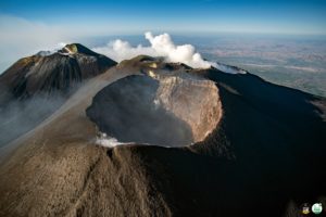
Indonesia , Karangetang :
2.781°N, 125.407°E
Elevation 1797 m
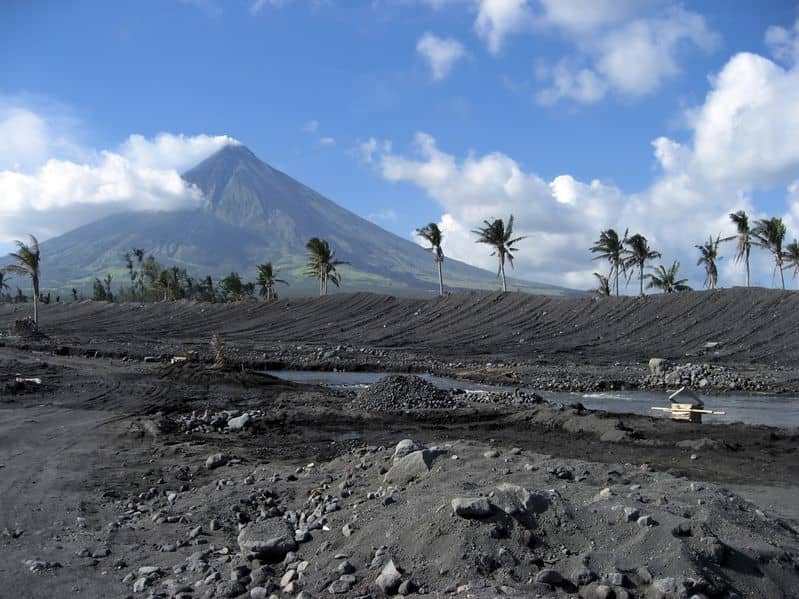
PVMBG reported that during 4-10 March a low rate of lava effusion continued at Karangetang’s Kawah Dua (North Crater) as evident by avalanches in the Malabuhe River drainage on the NW flank. White plumes rose as high as 500 m above the rims of the summit craters during 4-12 March. The Darwin VAAC reported that on 7 March an ash plume rose to an altitude of 2.7 km (9,000 ft) a.s.l. and drifted SW. The Alert Level remained at 3 (on a scale of 1-4), and residents were warned to remain outside of the 2.5-km exclusion zone around the N and S craters, and additionally within 3 km WNW and 4 km NW.
Level III Activity Level (SIAGA). Mount Karangetang (1784 m) has been erupting since 25 November 2018.
Since yesterday and until this morning, the volcano was covered with fog. The wind is weak in the southwest and northeast.
Through the seismographs, on March 13, 2019, it was recorded:
5 avalanche earthquakes
33 emission earthquakes
8 hybrid / multiphase earthquakes
16 shallow earthquakes
4 distant tectonic earthquakes
Continuous tremor with an amplitude of 0.25 mm, dominant 0.25 mm.
Recommendations:
People around Karangetang and visitors / tourists should not approach, climb or move in the danger zone located 2.5 km from the summit of Kawah Dua (North crater) and the main crater (South). the sectoral expansion zone from Dua Crater west-northwest 3 km and north-north-east 4 km.
Communities around Karangetang in the Northwest Kawah Dua region, including Niambangeng Village, Beba Village and Batubulan Village, should be evacuated to a place protected from the threat of lava flows or hot clouds.
People living around rivers from the summit of Mount Karangetang must be prepared for the potential threat of lahars and sudden floods that can spread to the coast.
It is recommended that the community around Mount Karangetang prepare a mask for the nose and mouth to anticipate the potential danger of airway disruption in the event of ash rain.
Source: GVP , Pusat Vulkanologi dan Mitigasi Bencana Geologi (PVMBG, , also known as CVGHM).
Photo : Novryoz Takalamingan .
Philippines , Mayon :
MAYON VOLCANO BULLETIN 14 March 2019 08:00 A.M.
Six (6) phreatic eruption events were observed at 9:06 AM, 9:39 PM, 9:46 PM, 9:55 PM, 10:00 PM, and 10:59 PM yesterday. The ash plume generated from these events rose 200 meters, 500 meters, 200 meters, 500 meters, 700 meters, and 300 meters above the summit, respectively, before drifting west.
During the 24-hour observation period, Mayon Volcano’s seismic monitoring network recorded six (6) volcanic earthquakes and three (3) rockfall events. Moderate emission of white steam-laden plumes was observed creeping downslope before drifting west-southwest, south-southwest, west, and southwest. Fair crater glow from the summit could be observed at night. Sulfur dioxide (SO2) emission was measured at an average of 763 tonnes/day on 13 March 2019.
Alert Level 2 currently prevails over Mayon Volcano. This means that Mayon is at a moderate level of unrest. DOST-PHIVOLCS reminds the public that sudden explosions, lava collapses, pyroclastic density currents or PDCs and ashfall can still occur and threaten areas in the upper to middle slopes of Mayon. DOST-PHIVOLCS recommends that entry into the six kilometer-radius Permanent Danger Zone or PDZ and a precautionary seven kilometer-radius Extended Danger Zone or EDZ in the south-southwest to east-northeast sector, stretching from Anoling, Camalig to Sta. Misericordia, Sto. Domingo must be strictly prohibited. People residing close to these danger areas are also advised to observe precautions associated with rockfalls, PDCs and ashfall. Active stream/river channels and those identified as perennially lahar-prone areas on all sectors of the volcano should also be avoided especially during extreme weather conditions when there is heavy and prolonged rainfall. Civil aviation authorities must advise pilots to avoid flying close to the volcano’s summit as airborne ash and ballistic fragments from sudden explosions and PDCs may pose hazards to aircrafts.
Source : Phivolcs
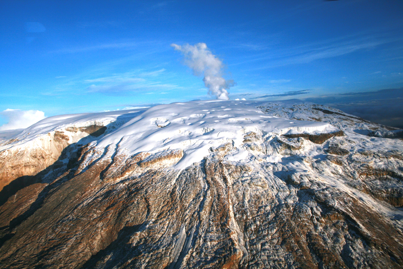
Colombia , Nevado del Ruiz :
Weekly activity bulletin of the Nevado del Ruiz volcano
The level of activity continues at the level: Yellow activity level or (III): Modifications of the behavior of the volcanic activity.
With regard to monitoring the activity of the Nevado del Ruiz volcano, the COLOMBIAN GEOLOGICAL SERVICE announces that:
Last week, the seismicity caused by rock fracturing showed similar levels in terms of the number of earthquakes and seismic energy released compared to the previous week. The earthquakes were located mainly in the South-East, South-West and North-East areas of the volcano and, to a lesser extent, in the Arenas crater, at depths between 1.4 and 7.2 km. The maximum magnitude recorded during the week was 1.0 ML (local magnitude) corresponding to the March 9 earthquake at 10:32 pm (local time), located in the Northeast sector, at a depth of 4.3 km.
Compared to the previous week, seismicity related to fluid dynamics within the channels of the volcanic structure showed a slight increase in both the number of earthquakes and the seismic energy released. This type of seismic activity was characterized by the presence of earthquakes of variable energy levels of long period (LP), very long period (VLP) and pulsations of volcanic tremor. The earthquakes occurred mainly in the crater Arenas and its surroundings.
Volcanic deformation, measured from electronic inclinometers, has undergone some changes in recent weeks, probably associated with minor inflationary processes on the Nevado del Ruiz volcano, although these changes have been small in recent days.
The volcano continues to emit water vapor and gases into the atmosphere, among which is the sulfur dioxide (SO2), as evidenced by the values obtained by the SCANDOAS stations installed in the region of the volcano. satellite image analysis. During the week, the NASA FIRMS portal reported a low-energy thermal anomaly.
The column of gas and steam reached a maximum height of 900 m, measured at the top of the volcano on March 11th. The direction of dispersion of the column was governed by the direction of the wind in the region, which prevailed towards the northwest of the volcano.
The Nevado del Ruiz volcano continues at the level of yellow activity.
Source : SGC
Photo : Auteur inconnu
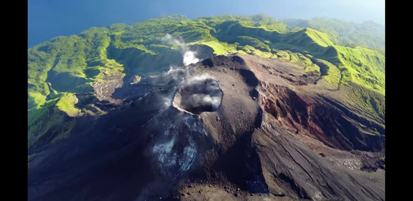
Japan , Suwanosejima :
29.638°N, 129.714°E
Elevation 796 m
JMA reported that crater incandescence at Suwanosejima’s Ontake Crater was visible at night during 1-8 March. Small events were occasionally recorded, generating plumes that rose as high as 600 m above the crater rim. The Alert Level remained at 2 (on a 5-level scale).
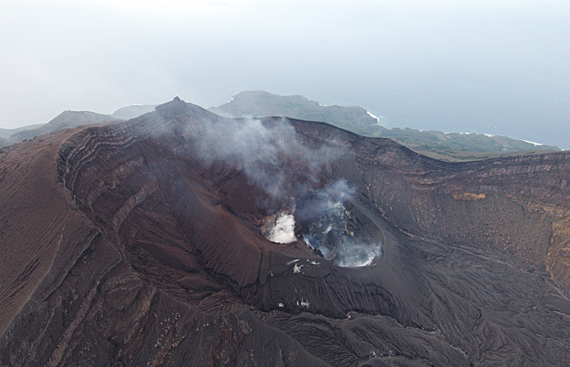
Aerial view of the Sakuchi caldera.
The 8-km-long, spindle-shaped island of Suwanosejima in the northern Ryukyu Islands consists of an andesitic stratovolcano with two historically active summit craters. The summit of the volcano is truncated by a large breached crater extending to the sea on the east flank that was formed by edifice collapse. Suwanosejima, one of Japan’s most frequently active volcanoes, was in a state of intermittent strombolian activity from Otake, the NE summit crater, that began in 1949 and lasted until 1996, after which periods of inactivity lengthened. The largest historical eruption took place in 1813-14, when thick scoria deposits blanketed residential areas, and the SW crater produced two lava flows that reached the western coast. At the end of the eruption the summit of Otake collapsed forming a large debris avalanche and creating the horseshoe-shaped Sakuchi caldera, which extends to the eastern coast. The island remained uninhabited for about 70 years after the 1813-1814 eruption. Lava flows reached the eastern coast of the island in 1884. Only about 50 people live on the island.
Source: GVP , Japan Meteorological Agency (JMA)