April 25 , 2018.
Stromboli , Italy :
This morning, April 24, the National Institute of Geophysics and Volcanology (INGV) recorded an intense explosive sequence on the Stromboli volcano that involved the mouths of the south-central zone located on the crater terrace. A first explosion, at 11:05, emitted an abundant column of ash mixed with incandescent material and large blocks of lava that fell back into the summit area and along the Sciara del Fuoco. The delivered products exceeded a height of 250 m above the crater terrace, as evidenced by the CCTV cameras of the INGV-OE Etneo Observatory.
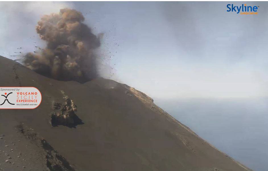
This explosion was followed by a second explosive event at 11:06, characterized by a modest fountain. At 11:10, the closing event of the sequence with the launch of pyroclastic material was of lower intensity, compared to the first explosion. Overall, this explosive sequence produced a cloud of ash that quickly dispersed into the southeast quadrants of the island. The launching of coarse pyroclastic materials was radial and fell on the crater terrace and along the Sciara del Fuoco.
Violent explosive sequences, such as that described and classified as major explosions, also occurred recently, on March 18 and 7, and in 2017, on December 1, November 1, October 23 and July 26. These are more violent explosions than those of ordinary Strombolian activity, during which coarse material and ashes are emitted, which falls into the area of the summit.
These events, occasional and unpredictable, abruptly interrupt ordinary Strombolian activity. However, they are part of the volcanic phenomenology typical of the peak activity of Stromboli, characterized by explosions of variable energy. The activity of Stromboli is constantly monitored by the INGV through its sections of Catania, Naples and Palermo.
Source : INGV
Photo : Webcam Skyline.
Vidéo : INGV
Kilauea , Hawai :
HVO/USGS Volcanic Activity Notice
Current Volcano Alert Level: WATCH
Current Aviation Color Code: ORANGE
Issued: Tuesday, April 24, 2018, 4:28 PM HST
Source: Hawaiian Volcano Observatory
Notice Number:
Location: N 19 deg 25 min W 155 deg 17 min
Elevation: 4091 ft (1247 m)
Area: Hawaii
Volcanic Activity Summary:
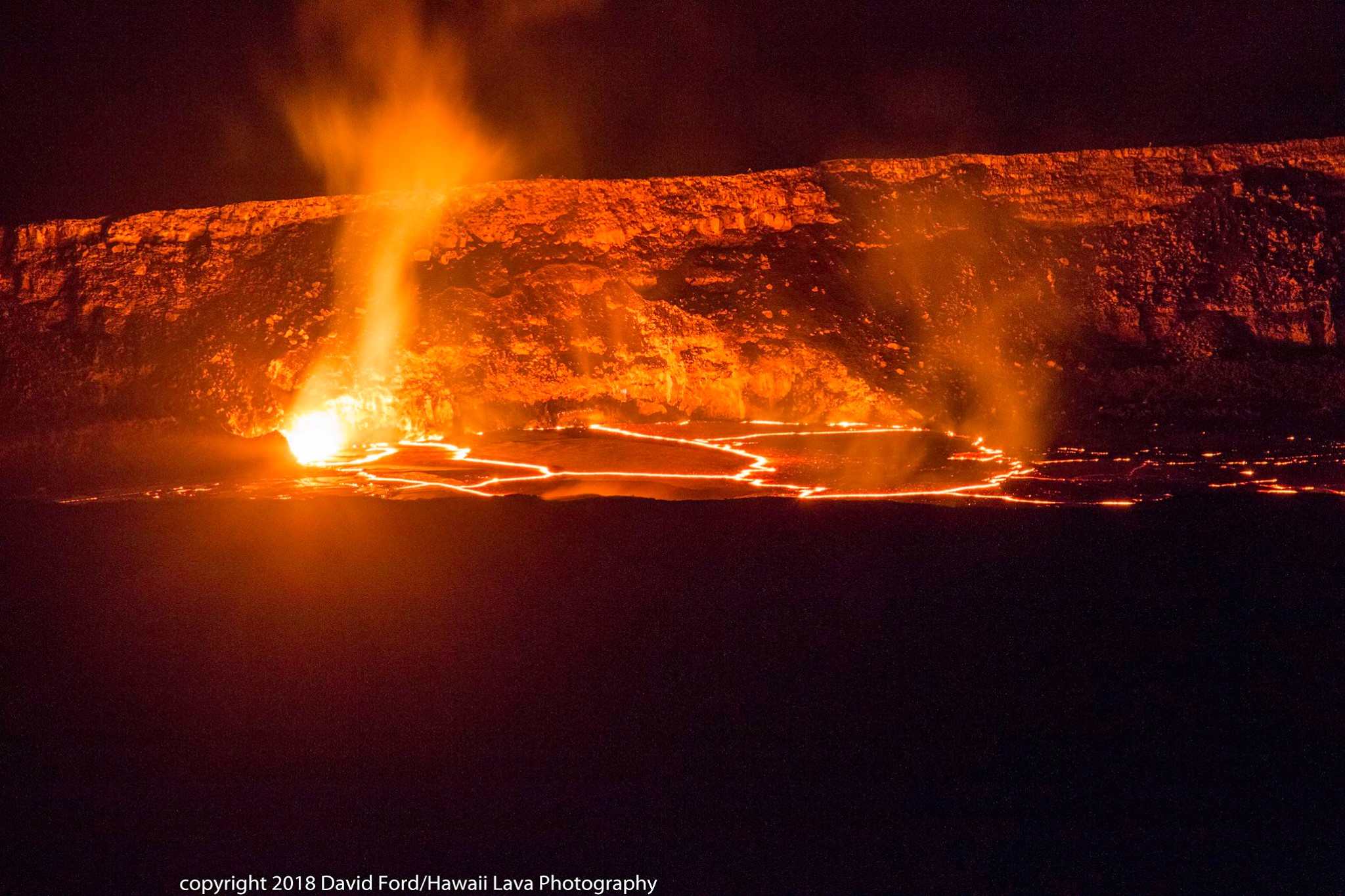
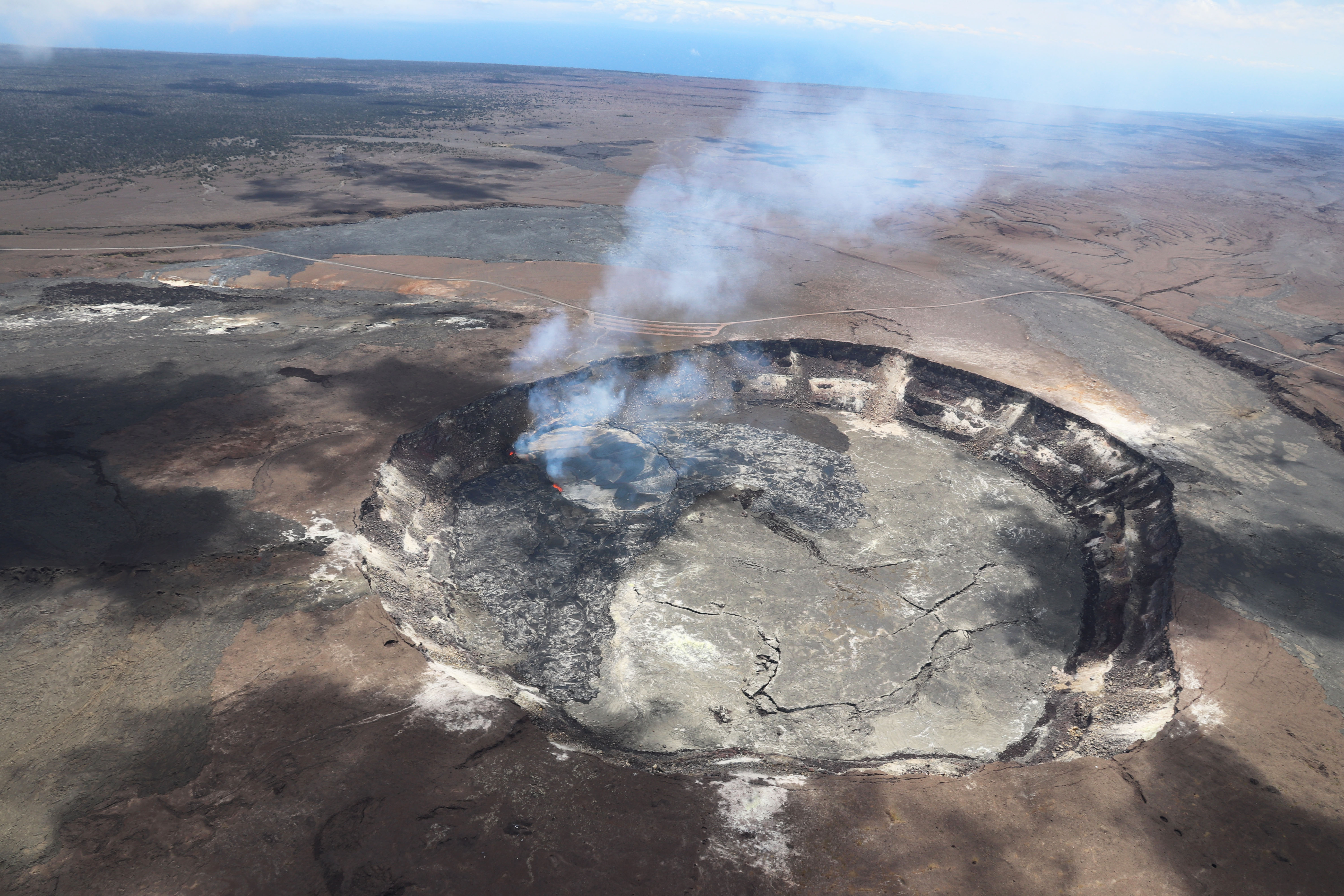
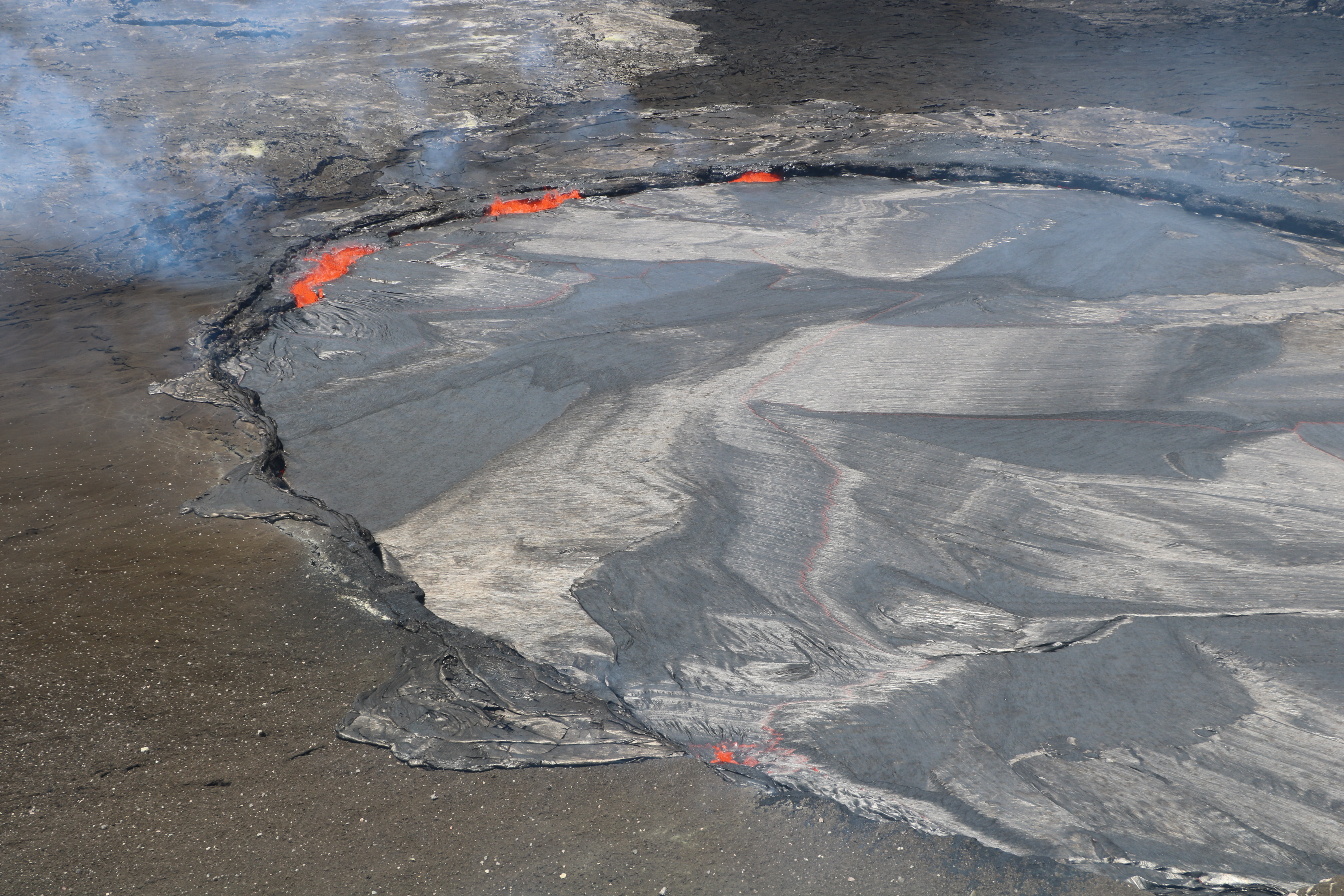
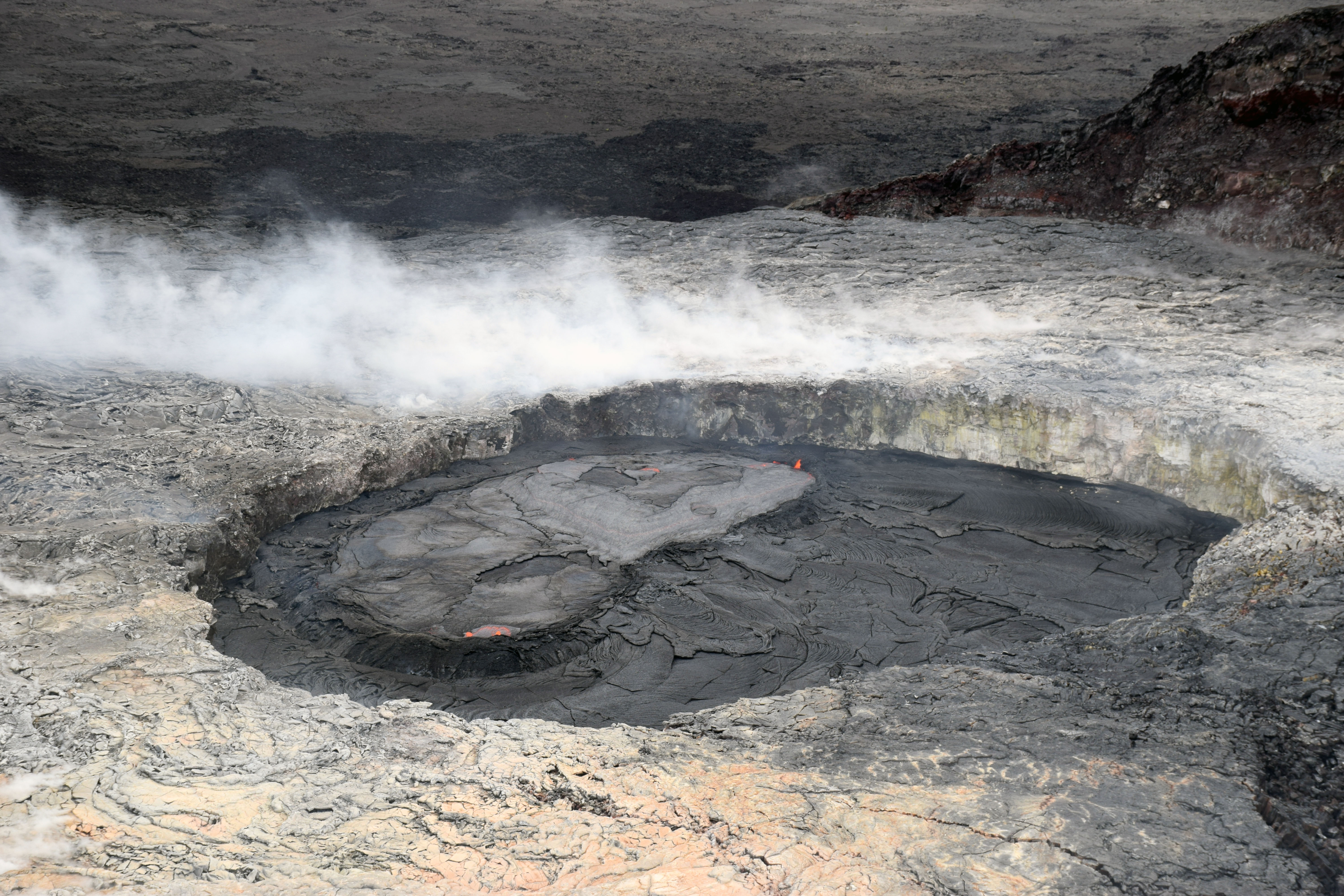
High lava lake levels in the informally named “Overlook crater” within Halemaʻumaʻu at the summit of Kīlauea Volcano have resulted in a series of overflows of lava onto the Halemaʻumaʻu crater floor beginning late on April 21 and continuing intermittently through this morning. These are the first significant overflows of the summit lava lake since May 2015 (a small overflow also occurred in October 2016). Accompanying this high stand of lava within the Overlook crater are nearly continuous areas of spattering along the margins of the lava lake, providing good views from Hawai‘i Volcanoes National Park’s Jaggar Museum Overlook. Sulphur dioxide gas emissions from the lake remain elevated.
Recent Observations
Since mid-March 2018, tiltmeters and GPS instruments have recorded an overall trend of inflationary tilt at the summit of Kīlauea Volcano reflecting an increase in the amount of magma in the shallow magmatic reservoir. In response, the lava lake within the Overlook crater has risen, reaching levels high enough for lava to flow over the crater rim and spread to the north, south, and southwest of the vent. A series of overflows, each lasting tens of minutes to several hours, occurred between April 21 and April 24. Between overflows, the lava column receded below the Overlook crater rim before rising again.
Based on HVO web camera records and direct observations, these flows are similar to those produced in the April-May 2015 overflows. They consist of lobate sheets of shelly pāhoehoe traveling as far as 375 m (about a quarter mile) across the floor of Halemaʻumaʻu. As of midday April 23, the new lava flows had covered about 40 acres (about 30 percent) of the floor of Halemaʻumaʻu. Each overflow also adds some height to the enclosing vent rim.
Photos of the overflows can be seen on the HVO web site at: https://volcanoes.usgs.gov/volcanoes/kilauea/kilauea_multimedia_15.html
Beginning in mid-April 2018 and continuing through the current high lava lake level and subsequent overflows, HVO seismometers recorded an uptick in small earthquakes beneath Kīlauea’s summit and upper East Rift Zone reflecting increased pressurization. However, unlike the April-May 2015 event, no bursts of earthquakes or deformation indicating an intrusion of magma into the southern caldera region of Kilauea have yet been recorded.
Although Kīlauea’s summit and East Rift Zone magma systems are connected, with changes at one sometimes leading to changes at the other, the Puʻu ʻŌʻō vent on Kīlauea Volcano’s East Rift Zone has shown no direct response to the recent overflows. However, HVO tiltmeters, GPS, web cameras, and field observations, continue to record inflation of Puʻu ʻŌʻō and the upper portion of the Episode 61g lava tube system, which could lead to the opening of a new vent on or near Pu‘u ‘Ō‘ō. If/when that happens, it is possible, even likely, that the summit lava lake will be affected, most likely by a significant drop in the lake level.
Hazard Analysis
High levels of sulfur dioxide gas, rockfalls, and explosions remain the primary hazards of concern. While the lake level is high, the risk of rockfalls and subsequent explosion of molten spatter and rock debris onto the southeast rim of Halemaʻumaʻu is slightly elevated due to the shorter vertical distance from the lake surface to the crater rim. These rockfalls and explosions can occur suddenly and without warning, underscoring the extremely hazardous nature of the Halema’uma’u rim, an area that has been closed to the public since late 2007.
Visitors to the Hawai’i Volcanoes National Park Jaggar Museum Overlook and other Park areas should also note that under southerly (non-trade) wind conditions, rockfalls and explosions can result in a dusting of powdery to gritty ash composed of volcanic glass and rock fragments. These ashfalls represent a minor hazard, but visitors should be aware that dustings of ash at Jaggar Museum and other areas around the Kīlauea summit are possible.
Remarks: The current high level of lava within the Overlook crater within Halemaʻumaʻu is best explained by an increase in the amount of magma stored within Kīlauea Volcano’s shallow magma system, something that has occurred many times during the ongoing East Rift Zone eruption. This increase is also responsible for the continuing inflation and elevated microearthquake activity in the summit region.
However, the exact cause of increased magma within the shallow storage system at Kīlauea’s summit is not known. Possible causes include (1) increased magma supply from deeper sources within the volcano, (2) a constriction or blockage in the conduit that carries magma from the summit storage system to the East Rift Zone, or (3) some combination of both.
During similar lava lake activity at Halemaʻumaʻu in the 1800s and early 1900s, lava lakes like the current one frequently produced overflows. With time, overflows and intermittent lava spattering can build a collar or levee of solidified lava that contains the rising and circulating lava lake. This phenomenon is known as a “perched lava lake.”
As long as Kīlauea’s summit magma reservoir remains pressurized and the current inflationary trend continues, we expect high lava lake levels, occasional overflows on the Halemaʻumaʻu floor, and possibly formation of a perched lava lake. Rockfalls into the summit lava lake accompanied by explosions and ejection of molten spatter and rock debris may occur and gas emissions will continue to be elevated. Ongoing spattering from sources on the surface of the lake will continue to produce fine ash and Pele’s hair that can be blown far downwind.
HVO is closely monitoring Kīlauea Volcano, especially watching for any signs of unrest that could precede a new outbreak of lava or a change in behavior at either the Puʻu ʻŌʻō or summit Overlook crater vents.
Source : HVO
Photos : David Ford , HVO.
Karymsky , Kamchatka :
VOLCANO OBSERVATORY NOTICE FOR AVIATION (VONA).
Issued: April 25 , 2018.
Volcano:Karymsky (CAVW #300130)
Current aviation colour code:YELLOW
Previous aviation colour code:orange
Source:KVERT
Notice Number:2018-37
Volcano Location:N 54 deg 2 min E 159 deg 26 min
Area:Kamchatka, Russia
Summit Elevation:4874.08 ft (1486 m)
Volcanic Activity Summary:
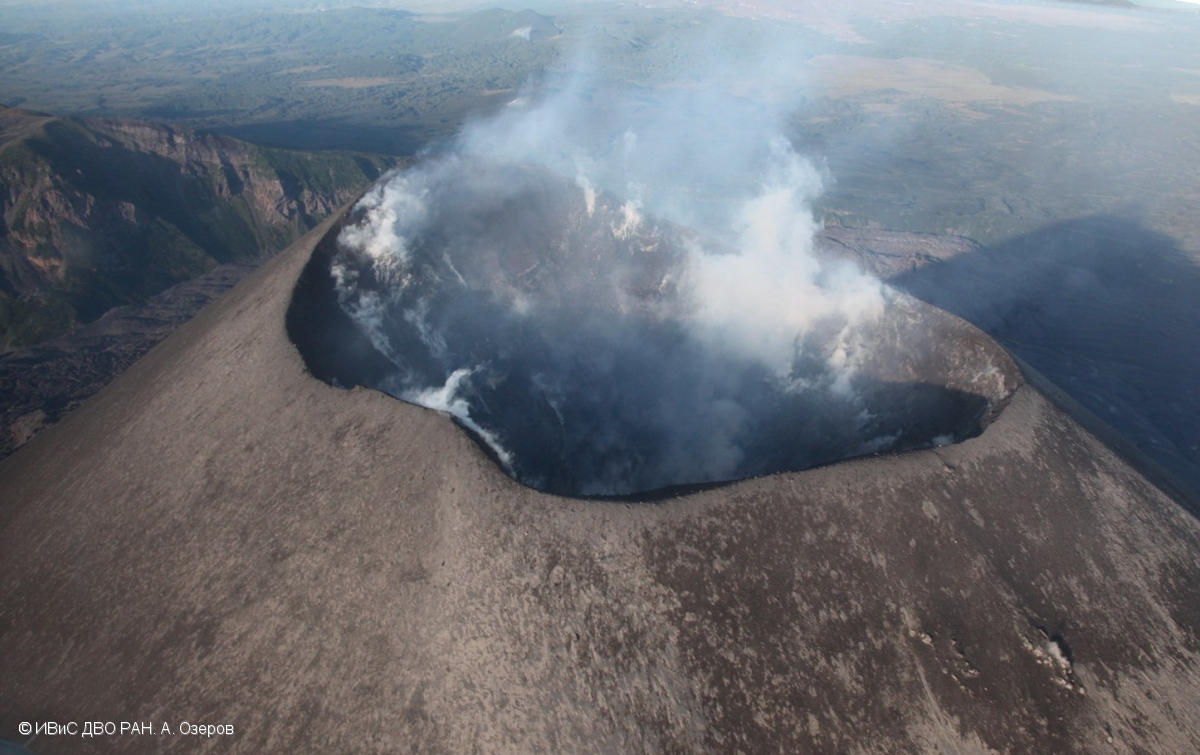
A moderate gas-steam activity of the volcano continues. According to satellite data, last explosive event at the volcano was registered on 27 January, 2018. A thermal anomaly over the volcano was noted last time on 26 March, 2018;the volcano was quiet or obscured by clouds in the other days. KVERT continues to monitor Karymsky volcano.
A moderate gas-steam activity of the volcano continues. A danger of ash explosions up to 16,400-23,000 ft (5-7 km) a.s.l. is remains. Ongoing activity could affect low-flying aircraft.
Volcanic cloud height: NO ASH CLOUD PRODUSED
Other volcanic cloud information: NO ASH CLOUD PRODUSED
Source : Kvert
Photo : A. Ozerov, IVS FEB RAS , 6/9/2017
Cumbal , Colombia :
Subject: Cumbal Volcano Activity Bulletin.
The level of activity of the volcano is maintained at the level:
YELLOW LEVEL ■ (III): CHANGES IN THE CONDUCT OF VOLCANIC ACTIVITY
Following the activity of the CUMBAL VOLCANIC COMPLEX, the COLOMBIAN GEOLOGICAL SERVICE informs that:
For the week between 17 and 23 April 2018, the seismic activity recorded a slight increase compared to the previous week, from 403 to 468 events, these earthquakes being mainly associated with movements of fluids at the same time. inside the volcano. Most of the fracturing-type earthquakes were located in the vicinity of the active La Plazuela cone in the north-east of the volcanic complex, with the furthest epicenter up to a distance of 10 km, and depths between 0 , 5 and 12 km under the summit (4700 m), the maximum local magnitude was M2.1 on the Richter scale.
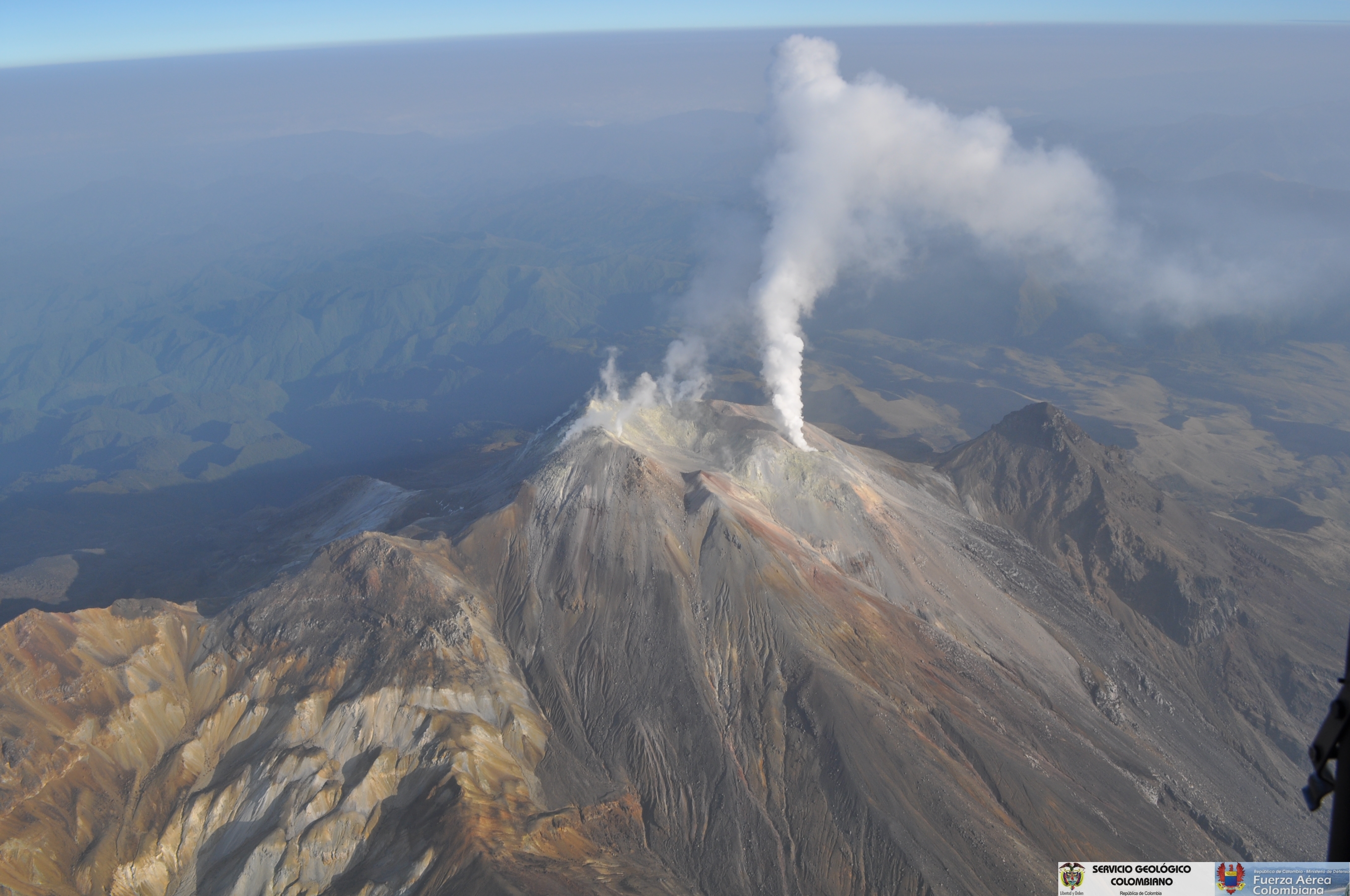
Favorable atmospheric conditions at the summit revealed gas emissions during the days 17, 20, 21 and 22 April, mainly from the El Verde fumarol field, northeast of the volcanic complex; the emission columns were observed white, of low height and variable dispersion according to the direction of the wind.
The COLOMBIAN GEOLOGICAL SERVICE is attentive to the evolution of the volcanic phenomenon and will continue to inform in a timely manner of the detected changes.
Source : SGC