February 23 , 2019.
La Réunion , Piton de la Fournaise :
Activity bulletin from Friday, February 22, 2019 at 1:30 pm (local time).
The eruptive activity that resumed on February 19, 2019 at Piton de la Fournaise around 7:10 pm local time continues. The intensity of the eruptive tremor (indicator of the intensity of the eruption) is relatively constant since February 20 at 06h local time (Figure 1).
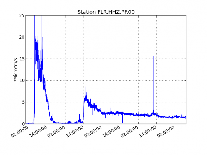
Figure 1: Evolution of the RSAM (indicator of the volcanic tremor and the intensity of the eruption) between 09h48 (05h48 UTC) on February 18th and 13h30 (09h30 UTC) on February 22nd on the seismic station of FLR. (© OVPF / IPGP)
– Over the last 36 hours, 22 superficial volcano-tectonic earthquakes (above sea level) have been recorded.
– After a deflation of the building related to the transfer of magma that occurred on 18/02/2019, the deformations of the summit zone do not show any particular signals.
– The CO2 concentrations in the near-field soil (gîte du volcan area) remain high.
– Over the last 36 hours, surface flows estimated from satellite data, via the HOTVOLC platform (OPGC – University of Auvergne), were between 2.5 and 15 m3 / s. The amount of lava emitted since the resumption of activity on 19/02/2019 is between 1 and 3 million m3.
A first mapping of the two eruptive phases (18 and 19/02/2019) was carried out yesterday by the OI2 platform (OPGC – University Clermont Auvergne) from satellite data (Figure 2).
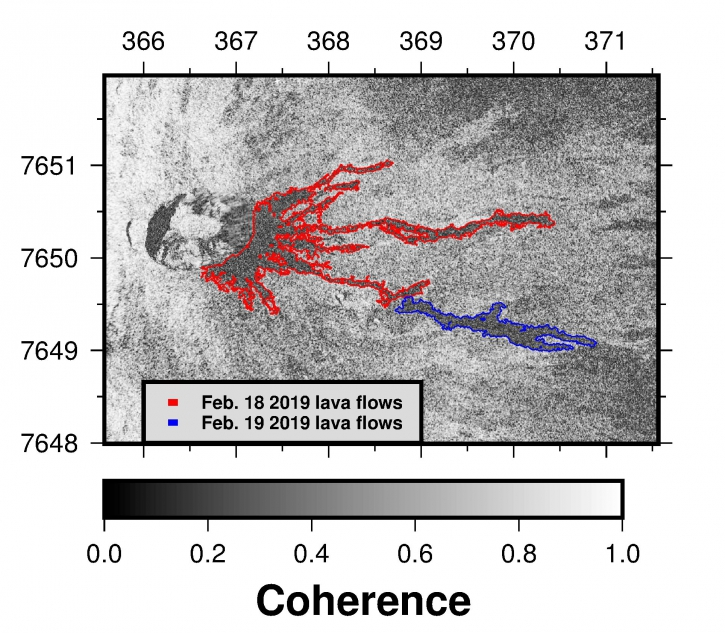
Figure 2: Contours of the eruptive phase flows of 18 and 19/02/2019 determined from satellite data by the platform OI2 (Clermont Auvergne University).
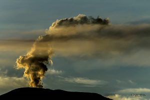
Observations made during an overflight this morning of the eruption zone by a member of the OVPF show that the contour of the flow has slightly changed even if its propagation is slow. The eruptive cone continues to grow and is now occupied by a lava lake from which ejecta escape during the explosion of bubbles arriving at the surface.
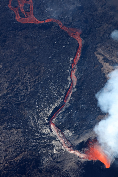
Figure 3: Shooting of the eruptive site on 22/02/2019 7h30 local time. (© OVPF / IPGP)
A flow, well channeled escapes downstream of the cone (Figure 3). After 1 km (and 200 m of negative elevation) it is no longer one but two runners that are observable. The separation of the flows is at the level of Guyanin crater. The arm to the north, about fifty meters wide, had not yet been observed during previous aerial reconnaissance by members of the OVPF and its front this morning was located at 1320 m altitude. It is the only one where one can distinguish a flowg with a « free flow ». The part of « red lava » is set up on a recent flow (probably set up yesterday or last night) now frozen and whose front is 1 km lower than the current moving front. The arm that bypasses Guyanin from the south spread to about 200 m wide and split into two arms about 300 m southeast of Guyanin. The first, the most southerly, stops at 1350 m above sea level, the second at 1300 m.

In total, the longest arm has traveled a distance of 1900 m from the eruptive vent and is still 4.3 km from the road and 5.3 km from the ocean. The different stream fronts are currently in the Great Slopes.
This toponym is related to the inclination of the topography which exceeds 30%. If the or / and flows arms have to be further advanced, they will meet within 1.7 km of the lower slopes between 10 and 20%, and in this case without increasing flow rates. their progress should slow down.
Source : OVFP.
Photos : OVFP , Mon Ami.
Indonesia , Agung :
VOLCANO OBSERVATORY NOTICE FOR AVIATION – VONA.
Issued: February 22 , 2019
Volcano: Agung (264020)
Current Aviation Colour Code: ORANGE
Previous Aviation Colour Code: orange
Source: Agung Volcano Observatory
Notice Number: 2019AGU08
Volcano Location: S 08 deg 20 min 31 sec E 115 deg 30 min 29 sec
Area: Bali, Indonesia
Summit Elevation: 10054 FT (3142 M)
Volcanic Activity Summary:
Eruption with volcanic ash cloud at 08h31 UTC (16h31 local)
Volcanic Cloud Height:
Best estimate of ash-cloud top is around 12294 FT (3842 M) above sea level, may be higher than what can be observed clearly. Source of height data: ground observer.
Other Volcanic Cloud Information:
Ash-cloud moving to east
Remarks:
Seismic activity recorded with maximum amplitude 11 mm and maximum duration 380 second.
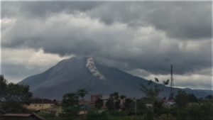
Mount Agung in Karangasem regency, Bali, erupted on Friday, spewing up a column of ash 700 meters from the crater.
The volcano’s observatory post reported that the eruption was recorded at 4:31 p.m.
After the first eruption, a smaller eruption occurred at 5:01 p.m. with the volcano spewing up a column of ash 300 meters high.
The Center for Volcanology and Geological Disaster Mitigation (PVMBG) maintained the volcano’s alert status at level three of the four-tiered alert system. The danger zone similarly remains within a 4-kilometer radius from the crater. The PVMBG also issued a code orange volcano observatory notice for aviation (VONA).
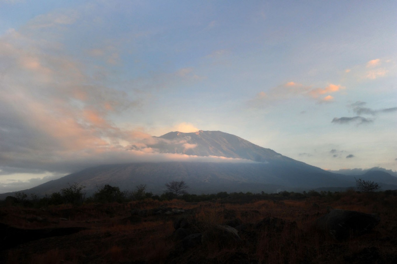
The Mount Agung volcano spews smoke, as seen from Nusu village, Karangasem regency, Bali, on July 29, 2018. (AFP/Sonny Tumbelaka)
« Mount Agung erupting is considered normal given that there has been an increase in volcanic activity in the last few days, » a senior official of the center, Devy Kamil Syahbana, told The Jakarta Post.
Devy added that the volcano might erupt again at a small scale.
The center also advised residents and tourists to steer clear of the danger zone. A ban on trekking Mt. Agung has been in place since 2017.
Source : Magma Indonesia , The Jakarta Post.
Photo : AFP/Sonny Tumbelaka
Video : Karangvision
Chile , Copahue :
Special Report on Volcanic Activity (REAV), Bio-Bio Region, Copahue Volcano, 22 February 2019, 11:00 Local Time (Continental Chile).
The National Geological and Mining Service of Chile (Sernageomin) publishes the following PRELIMINARY information, obtained through monitoring equipment of the National Volcanic Monitoring Network (NVRN), processed and analyzed at the Volcanological Observatory of the Southern Andes (OVDAS) :
Today, Friday 22 February 2019, at 01:02 local time, the monitoring stations installed near the Copahue volcano recorded an earthquake associated with a process of fracturing rocks (Volcano-tectonic type), associated with a fracturing process of rocks. In total, 343 events were recorded until the publication of this report. The most important event was located 13.8 km northeast of the main crater.
It has also published two REAV reports dated February 22, 2019, at 18:30 and 19:40. (see http://sitiohistorico.sernageomin.cl/volcanes.php, Ed).
The characteristics of the most important event, after its analysis, are as follows:
TIME OF ORIGIN: 04h30 Local time (GMT -3)
LATITUDE: -37.766833 ° S
LONGITUDE: -71.051167 ° W
DEPTH: 7.37 KM
LOCAL MAGNITUDE: 2.5 (ML)
OBSERVATIONS:
At the time of issuing this report, events of equal or lower magnitudes continue to be recorded. Events of greater magnitudes have been reported as felt by the community of Caviahue, Argentina.
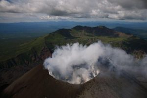
It is not possible to observe the superficial activity because of the weather conditions.
Volcanic Technical Alert Level Remains at Green Level
Sernageomin continues online monitoring and will inform in a timely manner about any changes observed.
Source : Sernageomin .
Photo : Sernageomin
Costa Rica , Turrialba / Poas / Rincon de la Vieja :
Daily report of the state of volcanoes. Date: February 22, 2019, Updated at: 10:56:00 AM.
Turrialba Volcano
On 22 February 2019, at 00:00 local time, there is an eruption on the Turrialba volcano, with a column that rises 300 meters above the crater height and 3,640 meters above sea level. (meters above sea level, 11939.2 ft).
Duration of the activity: minutes.
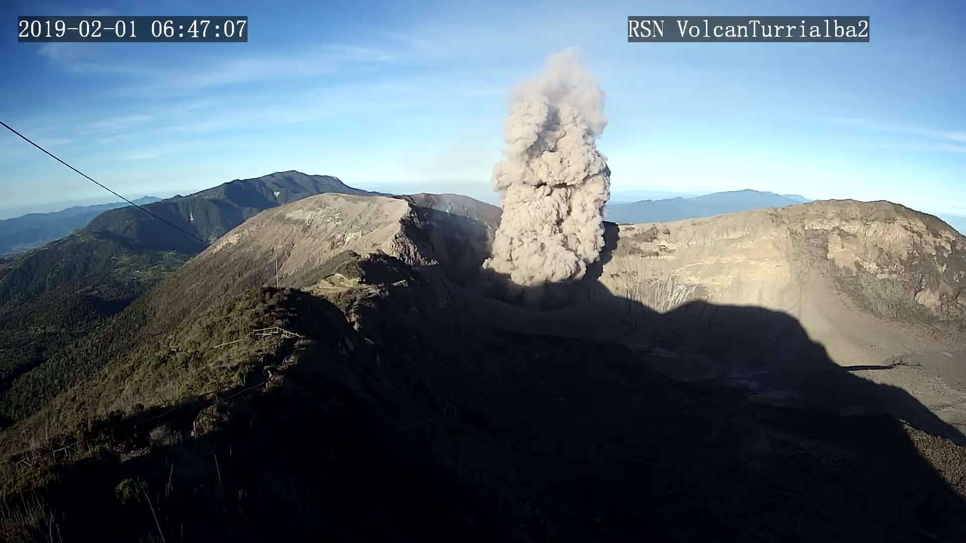
The seismic activity is similar to that of yesterday.
At the time of this report, the winds blow from the northwest.
Ashes continue almost continuously. Ashes have been reported in Santa Cruz and Santa Ana and a smell of sulfur in Moravia.
Poas Volcano:
No eruption is reported.
The seismic activity is similar to that of yesterday.
At the time of writing, winds are blowing from the southwest.
The CO2 / SO2 and H2S / SO2 ratios returned to normal values. The SO2 flow rate was measured at low values.
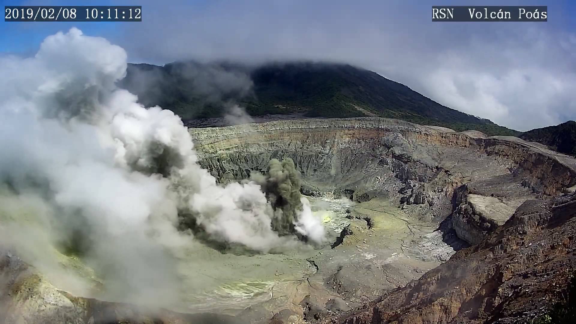
Visitors to the Poás Volcano National Park are reminded that this site has protocols for eruptions. Depending on the type of activity, visits may be suspended or delayed. In the perspective of the main crater, there are four shelters to protect themselves in case of eruption. Tourists are always asked to be attentive to any change of activity and to follow the instructions of the park wardens.
Rincon de la Vieja Volcano:
No eruption is reported.
The seismic activity is similar to that of yesterday.
The wind direction is unknown at the moment.
The tremor persists.
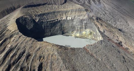
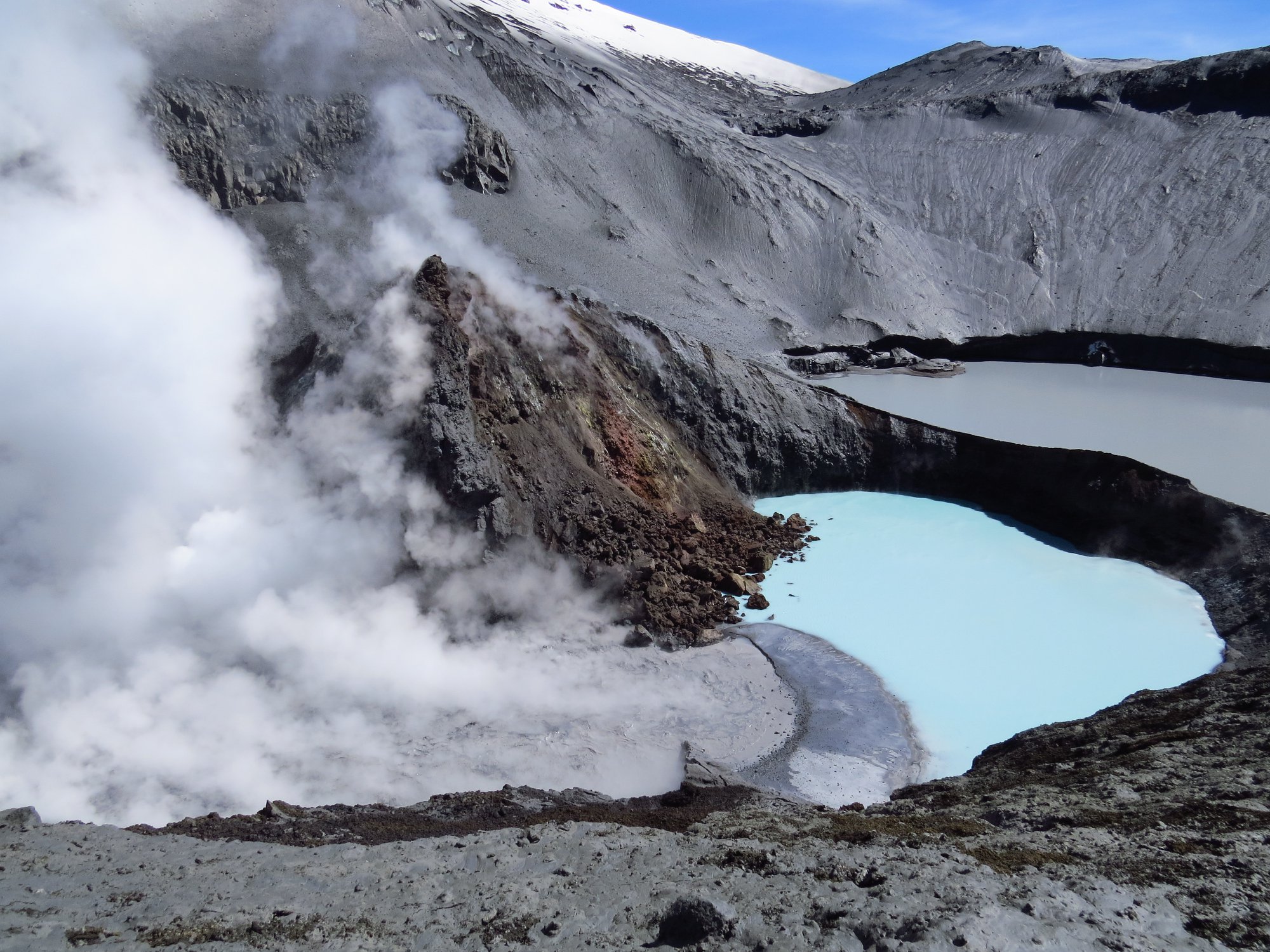
In this photo, taken on February 17, 2019, you can see the active crater, the active fumaroles and the acidic lake with a significant level drop of a few meters, in the background the crater Von Seebach . Photograph provided by Chris Allen of Sunquest Helitours.
On February 12th, a climb to the active crater was carried out and a significant decrease in the order of one meter at the level of the acidic lake was observed, as well as an intense fumarolic activity on the Southwest edge. It was also noted that the ash product of the 20 January eruption at 01:26 reached about 400 m to the south and east of the crater and affected some of the vegetation in the area.
Source : OVSICORI-UNA , RSN.
Photos : RSN , Chris Allen / Sunquest Helitours.