March 24 , 2018.
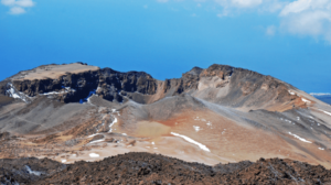
Nevado del Ruiz , Colombia :
Subject: Bulletin of activity of the Nevado del Ruiz volcano.
The level of activity continues at the level: Yellow activity level or (III): changes in the behavior of volcanic activity.
With regard to monitoring the activity of the Nevado del Ruiz volcano, the COLOMBIAN GEOLOGICAL SERVICE informs that:
During the last week, the Nevado del Ruiz volcano showed an increase in its seismic activity associated with the fracturing of rocks inside the volcanic edifice and the dynamics of the fluids in the volcanic ducts.
The seismicity caused by the fracturing of the rocks that make up the volcano, was located mainly in the south-eastern sector of the volcanic structure and to a lesser extent in the Arenas crater and the eastern and northern regions, at depths between 0.8 and 6.2 km. The seismic increase recorded on March 15 in the southeast of the volcano, with a maximum magnitude of 2.2 ML (local Magnitude) is highlighted. This quantity corresponds to the maximum value recorded during the week at 10:41 (local time), at a depth of 3.5 km.
Seismicity related to fluid dynamics within volcanic ducts was mainly characterized by the occurrence of multiple fluidic earthquakes, long-period events, and tremor pulses. The earthquakes were mainly located in the crater of Arenas and its surroundings. Volcanic deformation measured from electronic inclinometers, Global Navigation Satellite System (GNSS) stations and radar images shows stability behavior without recording significant deformation processes of the volcanic structure.
The volcano continues to emit into the atmosphere water vapor and gases, among which sulfur dioxide is distinguished (SO2), as evidenced by the values obtained by the SCANDOAS stations installed in the region of the volcano. analysis of satellite images. In monitoring the information provided by the MIROVA and NASA FIRMS portals, several thermal anomalies have been reported near the Arenas crater.
The column of gas and steam reached a maximum height of 1300 m measured at the top of the volcano, March 16. The direction of dispersion of the column was governed by the direction of the wind in the zone, which had a predominant direction towards the southwest, with respect to the Arenas crater.
The Nevado del Ruiz volcano continues at the level of activity yellow.
Source : SGC
Photo : Cesar Rios
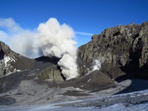
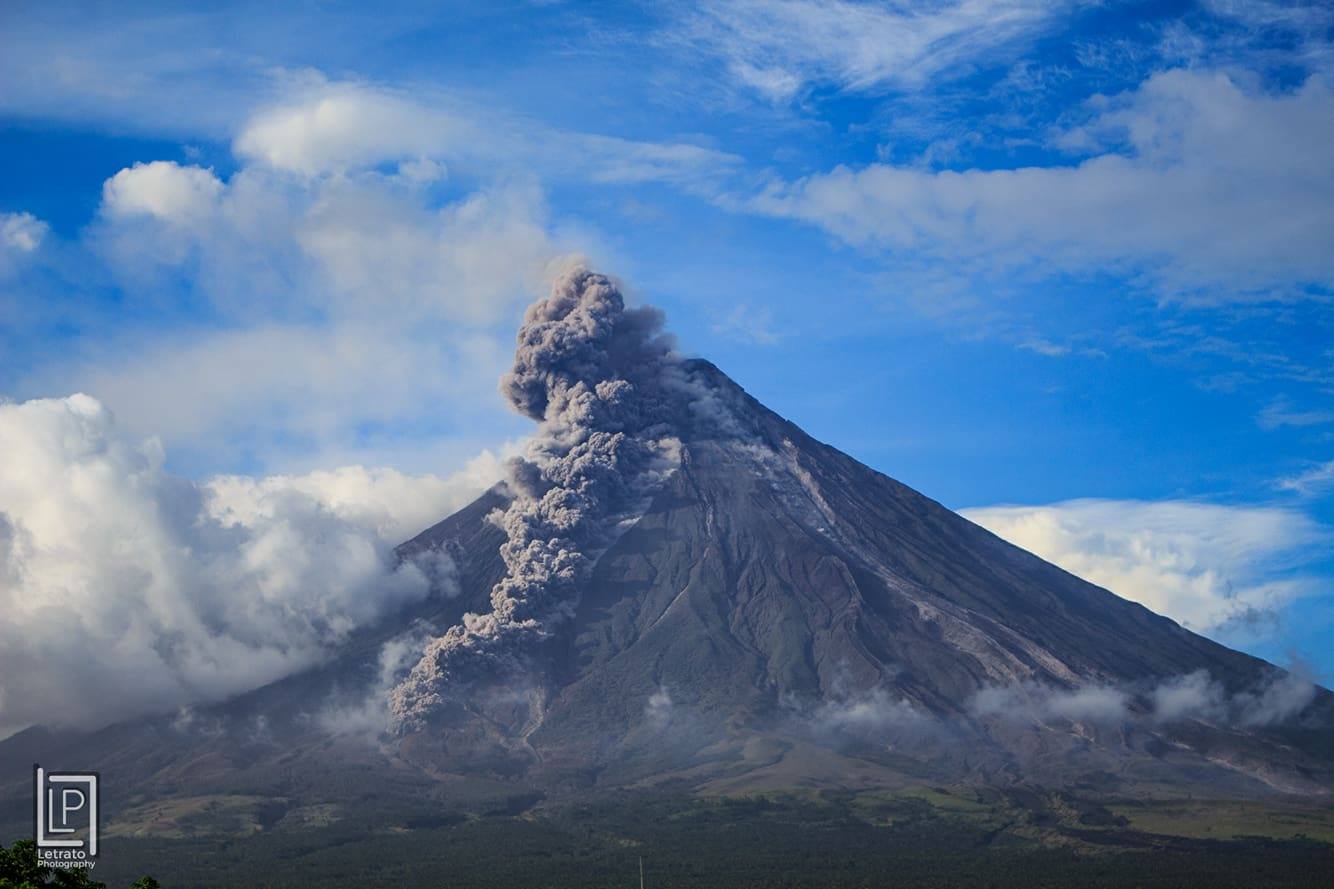
Mayon , Philippines :
MAYON VOLCANO BULLETIN 24 March 2018 08:00 A.M.
Mayon’s activity in the past 24 hours was characterized by relative quiescence on a background of intermittent lava collapse events. Two (2) episodes of lava-collapse pyroclastic density currents (PDC) on the Miisi Gully within 4-5 kilometers of the summit crater occurred at 10:39 AM and 9:33 PM yesterday generated light brown ash clouds that drifted southwest.
A total of thirty five (35) rockfall events were recorded by Mayon’s seismic monitoring network. Sulfur dioxide (SO2) emission was measured at an average of 1532 tonnes/day on 22 March 2018. Slight inflation of the lower slopes that began on 11 March is still being recorded by electronic tiltmeter, consistent with results of Precise Leveling (PL) surveys on 10 – 19 March 2018. Overall ground deformation data indicate that the edifice is still swollen or inflated relative to pre-eruption baselines.
Alert Level 3 currently prevails over Mayon Volcano. This means that although Mayon’s unrest continues, there is a decreased likelihood of hazardous explosive eruption to occur. PHIVOLCS-DOST reminds the public of sudden explosions, lava collapses, pyroclastic density currents or PDCs and ashfall can still occur and threaten areas in the upper to middle slopes of Mayon. PHIVOLCS-DOST recommends that entry into the six kilometer-radius Permanent Danger Zone or PDZ and a precautionary seven kilometer-radius Extended Danger Zone or EDZ in the south-southwest to east-northeast sector, stretching from Anoling, Camalig to Sta. Misericordia, Sto. Domingo, must be strictly prohibited. People residing close to these danger areas are also advised to observe precautions associated with rockfalls, PDCs and ashfall. Active river channels and those perennially identified as lahar prone areas in the southern and eastern sectors should also be avoided especially during bad weather conditions or when there is heavy and prolonged rainfall. Civil aviation authorities must advise pilots to avoid flying close to the volcano’s summit as airborne ash and ballistic fragments from sudden explosions and PDCs may pose hazards to aircrafts.
PHIVOLCS-DOST is closely monitoring Mayon Volcano’s activity and any new significant development will be immediately communicated to all stakeholders.
Source : Phivolcs
Photo : Letrato
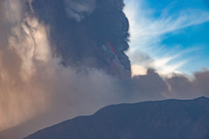
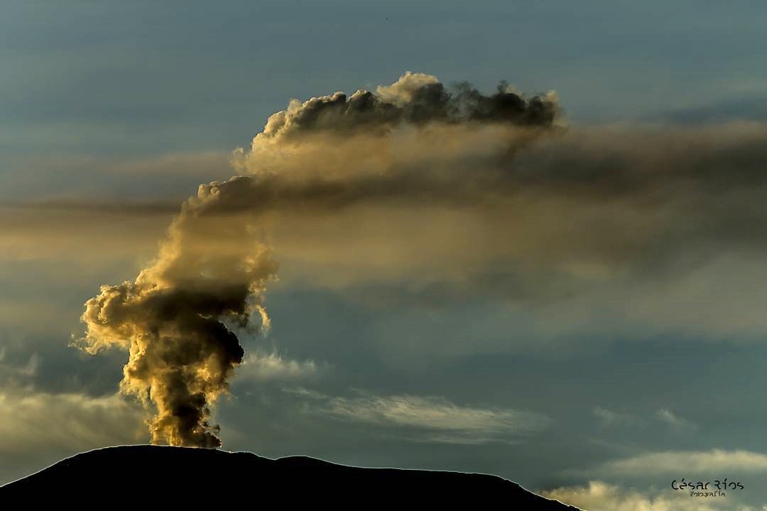
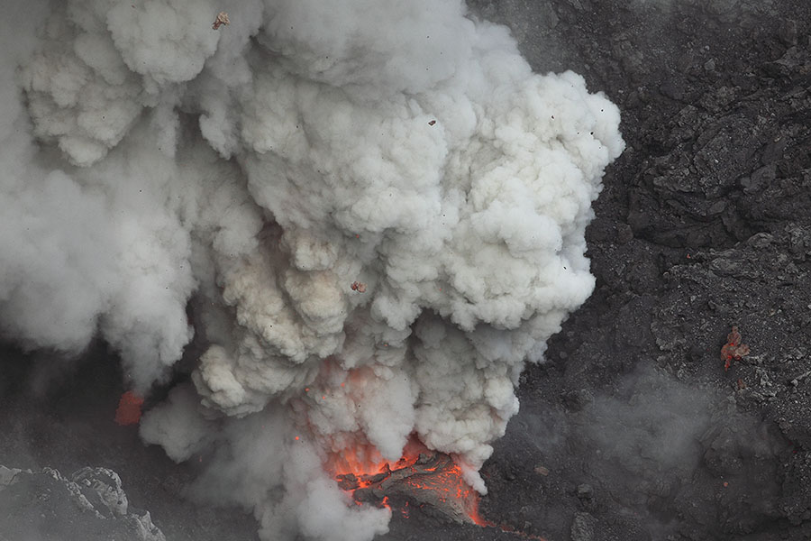
Dukono , Indonesia :
VOLCANO OBSERVATORY NOTICE FOR AVIATION – VONA.
Issued: March 24 , 2018
Volcano: Dukono (268010)
Current Aviation Colour Code: ORANGE
Previous Aviation Colour Code: orange
Source: Dukono Volcano Observatory
Notice Number: 2018DUK35
Volcano Location: N 01 deg 41 min 35 sec E 127 deg 53 min 38 sec
Area: North Maluku, Indonesia
Summit Elevation: 3933 FT (1229 M)
Volcanic Activity Summary:
Eruption with volcanic ash cloud at 00h18 UTC (09h18 local).
Volcanic Cloud Height:
Best estimate of ash-cloud top is around 4893 FT (1529 M) above sea level, may be higher than what can be observed clearly. Source of height data: ground observer.
Other Volcanic Cloud Information:
Ash cloud moving to South.
Remarks:
Eruption and ash emission is continuing.
Level II Activity Level (WASPADA). The Dukono (1229 m above sea level) has a continuous eruption.
Since yesterday until this morning visually the summit of the volcano can be observed. A column of white / gray ash, high pressure is observed, rising between 200 and 300 m. The wind is oriented towards the East.
The seismographs, dated March 10, 2018 recorded:
13 earthquakes of eruption.
1 Volcanic earthquake.
A continuous tremor associated with an ash eruption with an amplitude of 0.5 to 12 mm (dominant value of 2 mm).
Recommendation:
Communities around G. Dukono and visitors / tourists should not have activity, climb and approach the Malupang Warirang crater within 2 km.
Source : Magma , VSI.
Photo : Photovolcanica.
Sierra Negra , Galápagos , Ecuador :
Seismic activity
Since the special report No. 2 (January 22, 2018) has been published, it has been possible to continue to see high levels of seismic activity on the Sierra Negra volcano, in recent weeks and even days , to show peaks of more than 75 daily earthquakes (Fig. 1).
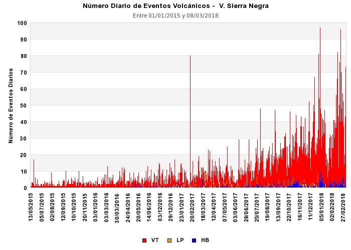
Figure 1. Number of daily earthquakes recorded in the Sierra Negra volcano since 2015.
Most earthquakes are of the volcano – tectonic (VT) type, which are associated with fracture movement due to the forces associated with volcano magma. There are also long-period (LP) earthquakes, in smaller quantities, that are generated by resonances or vibrations of volcanic fluids in cracks beneath the volcano. There are also minor events that combine the mechanisms of rupture of volcano – tectonic earthquakes and the resonance of long – lived earthquakes. These so-called hybrid earthquakes (HB) appear in small quantities.
Most of these events have been located inside the caldera (Fig. 2), with some events located on the upper flanks of the volcano.
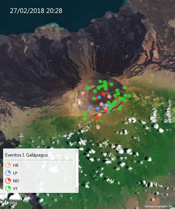
Figure 2. Locations of earthquakes in the Galapagos since January 2018. The types of earthquakes are marked with different colors, HB = hybrid, LP = long period, ND = not determined, VT = volcano tectonics. Note the large accumulation of events in the Sierra Negra volcano area.
18 TU 22h28 January (16h28 Galapagos local time): This earthquake had a magnitude of 4.4 and a very low focal depth (less than 1 km). The epicenter was located near the southern edge of the caldera. The spectrum has a frequency of 3 Hz as close as possible to the epicenter (VCH1 station) so that it is considered to be an LP-type earthquake.
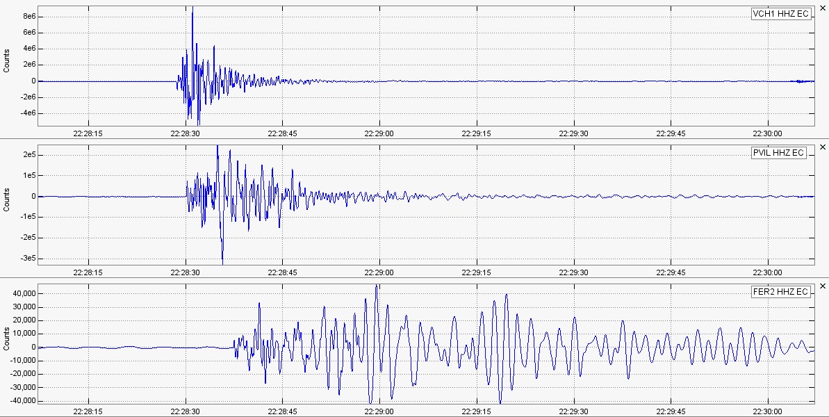
Figure 3. Earthquake recording on January 22 at VCH1, PVIL and FER2 of the seismic monitoring station network of the Institute of Geophysics.
February 27 8:28 pm UTC (14:28 local time Galapagos): This earthquake was magnitude 4.1. also with LP-like characteristics, which is generated by the resonance of the fluid in cracks or ducts, since most of its energy occurs in frequencies below 4 Hz. The focal depth is very shallow, which is inferior at 1 km.
March 14 14:41 UTC (08:41 local weather): This is the largest recorded earthquake on Sierra Negra and its magnitude is M 4.6. Its focal depth is 0.3 km, which qualifies it as very shallow. One could also identify the infrasound component, which, when compared with the seismic signal, suggests that pressure changes are induced by the vertical movement of the soil. It is important to note that this earthquake has been classified as LP. It should also be noted that this earthquake has a very low frequency secondary component and is interpreted as the movement of a viscous fluid.
Deformation
The deformation that occurred on the surface of the Sierra Negra volcano was detected by satellite radar interferometry (InSAR), through cooperation with the School of Marine and Atmospheric Sciences (RSMAS) at the University from Miami. The measurements obtained show a rapid inflation (uplift) of the caldera floor of the Sierra Negra volcano. At the beginning of January 2018, the accumulated deformation had already exceeded the deformation observed before the 2005 eruption. The average deformation rate is 15.01 cm / month since January 2018 (Figure 4).
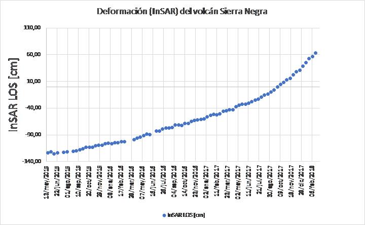
Figure 4. The blue dots represent the lifting of the cumulation floor since the beginning of 2015. It should be noted that the trend of inflation remains, the boiler and raising the floor of the caldera.
The distribution of this deformation on the surface is concentrated in the Sierra Negra caldera, as shown in Figure 5.
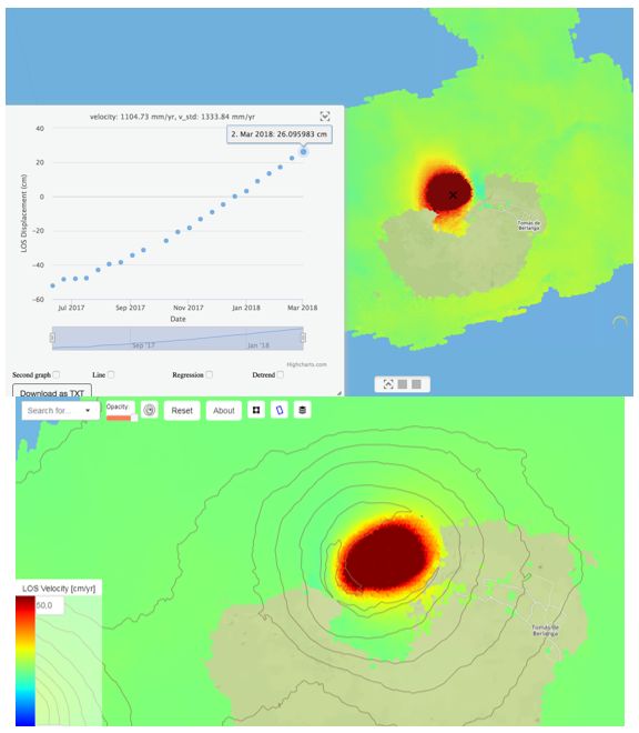
Figure 5. The InSAR analysis results in the Sierra Negra volcano region, in red, the region that has great deformation and which is located on the floor of the volcano’s caldera.
Geochemical monitoring
Between 6 and 9 February 2018, technicians from the Institute of Geophysics of the National Polytechnic School took measures for the geochemical monitoring of the Sierra Negra volcano in the sulfur mining area (Fig. 6), with support Ministry of the Environment and the Galapagos National Park (see the website of the Institute of Geophysics, www.igepn.edu.ec).
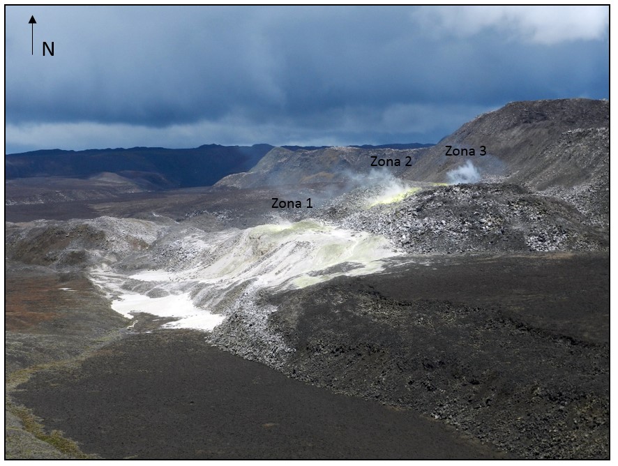
Figure 6. Overview of the fumarolic field in the Azufral sector south of the Sierra Negra volcano caldera. (06-02-2018, M Almeida – IGEPN).
During the visit, moderate surface activity was observed in all fields, with emission columns reaching a few meters (~ 20 m) above their emission center. Measurements were made with a multigas apparatus to quantify the CO2 / SO2 and SO2 / H2S ratios. Crossings were carried out with a mobile DOAS station in order to obtain the SO2 flux released by the fumarolic field. In addition, the temperatures at different points of the fumarolic zones were measured. The results of this campaign show that, at the geochemical level, at least for this hydrothermal event, there is no change compared to the measures taken in May 2014 and September 2017.
Interpretation
The recent increase in the number and magnitude of recorded earthquakes, as well as the location in the caldera zone, coupled with the accelerated rise in soil, are interpreted as associated with the appearance of an intrusion of magma that would accumulate inside the volcano. Similarly, the level of recorded internal turmoil implies that it is still possible for this volcano to erupt, however, the lack of a strong acceleration of the monitoring parameters indicates that the process could take weeks or even months.
Source : IGEPN