December 20 , 2018.
Colombia , Cumbal :
Weekly Cumbal Volcano Activity Bulletin
The level of activity of the volcano is maintained at the level: LEVEL YELLOW ■ (III): CHANGES IN THE BEHAVIOR OF THE VOLCANIC ACTIVITY
Following the activity of the CUMBAL VOLCANIC COMPLEX, the COLOMBIAN GEOLOGICAL SERVICE (SGC) reports that:
Compared to the previous period, between December 11 and December 17, 2018, the activity of the Cumbal volcanic complex was characterized by an increase in seismic frequency, with a record of low energy earthquakes associated with the movement of fluids in the volcanic ducts and others associated with the fracturing of cortical material.
Les émissions de gaz se sont maintenues dans le champ de fumerolles d’El Verde au Nord-Est du complexe volcanique, avec des colonnes blanches, de hauteur et de dispersion variables en raison de l’action des vents.
Le SERVICE GÉOLOGIQUE COLOMBIEN est attentif à l’évolution du phénomène volcanique et continuera d’informer en temps utile des changements détectés.
Source : SGC.
Photo : SGC
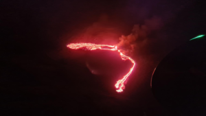
Vanuatu , Ambrym :
16.25°S, 168.12°E
Elevation 1334 m
The Vanuatu Meteorology and Geo-hazards Department (VMGD) reported that a fissure eruption in the ESE part of the Ambrym summit caldera near the Lewlembwi crater (4 km SE of Marum) began at 0600 on 15 December, heralded by elevated seismicity detected by the seismic network and ash emissions visible in the webcam. A notice issued later that day by VMGD stated that lava flows and lava fountains were visible, and explosions were occurring.
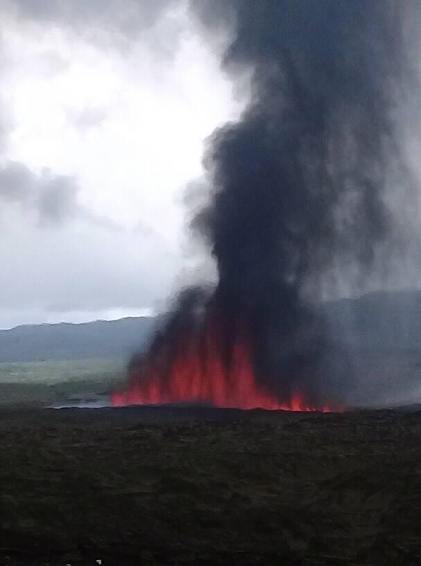
John Tasso, a local guide, visited the caldera a few hours after the new activity started and observed lava fountains from a fissure eruption; his video was posted to his website. The lava fountains were about 40 m high; lava flows spread to the E part of the caldera. Although partially obscured by a steam plume directly above the eruption site, infrared imagery from the Sentinel-2 satellite on 15 December showed lava filling much of the 500 x 900 m Lewlembwi crater and a lava flow almost as large a few hundred meters SW of that crater. VMGD raised the Alert Level to 3 and stated that the eruption was characterized as “small scale.” The eruption continued during 16-17 December, though reports on 17 December only described ongoing ash-and-gas emissions.
Sources: Vanuatu Meteorology and Geo-hazards Department (VMGD), John Tasso, Vanuatu Island Experience, Port Vatu, West Ambrym, Vanuatu, Sentinel Hub , GVP.
Photo : John Tasso Zulu
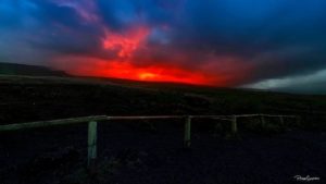
Iceland , Bárðarbunga / Herðubreið :
Intense earthquake swarm in Mt. Herðubreið continues, strong quake in Bárðarbunga.
An intense earthquake swarm in Mt. Herðubreið in the NE Central Highlands shows no sign of slowing down. Nearly two hundred quakes have been detected just south of the volcano since the swarm began shortly after nine yesterday morning. At quarter to seven yesterday evening the Herðubreið swarm was joined by a 3.4 magnitude quake in the central caldera of the Bárðarbunga system.
The Icelandic Meteorological Office located the epicenter of the 3.4 magnitude Bárðarbunga quake at a depth of only 800 m (o.5 mi) in the NE part of the caldera. A second 3.6 magnitude quake was detected in the same area on Monday morning.
Geologists believe the seismic activity in Bárðarbunga is caused by the volcano refilling its magma chambers since the 2014-15 Holuhraun eruption, while it is not immediately clear what causes the Herðubreið activity. Mt. Herðubreið, like all mountains in Iceland, is an extinct volcano, formed in a single eruption 10-11.000 years ago, toward the end of the last Ice Age. It is located within the Askja volcano system, a very active system. The area, however, is known for high levels of seismic activity, including fissure rifting events.
There are no signs of imminent volcanic activity geologists assure us.
The activity in Herðubreið began at 9:21 yesterday. It’s activity has been concentrated at a significant depth of a few kilometers just SW of Herðubreið. A high level of the quakes has been relatively powerful, 1+ on the Richter scale.
Source : icelandmag.is.
Photo : Extreme Iceland.
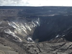
Alaska , Semisopochnoi :
AVO/USGS Volcanic Activity Notice
Current Volcano Alert Level: UNASSIGNED
Previous Volcano Alert Level: ADVISORY
Current Aviation Color Code: UNASSIGNED
Previous Aviation Color Code: YELLOW
Issued: Wednesday, December 19, 2018, 11:35 AM AKST
Source: Alaska Volcano Observatory
Notice Number:
Location: N 51 deg 55 min E 179 deg 35 min
Elevation: 2625 ft (800 m)
Area: Aleutians
Volcanic Activity Summary:
No eruptive activity has been detected at Semisopochnoi since November 1 when a satellite link for transmitting seismic data failed. Since that time, no changes have been observed in satellite data, and no explosions have been detected from the Adak Island infrasound array; the last explosion detected by infrasound was October 31.
View into the caldera from south of Anvil Pk (L). Perret Ridge (c) and Fenner Lake can be seen. Old lava flow from Cerberus in lower right. Photos of Semisopochnoi Island taken in May 2017 during AVO station maintenance activities and supported by U.S. Coast Guard.
AVO is lowering the Aviation Color Code to UNASSIGNED and Alert Level to UNASSIGNED for Semisopochnoi due to the lack of evidence for ongoing eruptive activity. Seismic unrest may be continuing undetected. Pauses in eruptions lasting weeks to months are known to occur during volcanic eruptions. A return to eruptive activity may occur with little or no warning.
Recent Observations:
[Volcanic cloud height] No cloud observed
[Other volcanic cloud information] No cloud observed
Remarks:
The seismic monitoring network for Semisopochnoi has been offline since November 1, but if atmospheric conditions permit an infrasound array on Adak Island may detect explosion signals from Semisopochnoi with a 13 minute delay. Semisopochnoi is also monitored remotely with satellite observations and lightning sensors.
Source : AVO
Photo : Kaufman, Max.
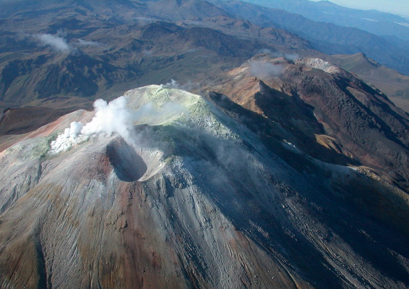
Indonesia , Anak Krakatau :
VOLCANO OBSERVATORY NOTICE FOR AVIATION – VONA.
Issued: December 2 , 2018 .
Volcano: Anak Krakatau (262000)
Current Aviation Colour Code: ORANGE
Previous Aviation Colour Code: orange
Source: Anak Krakatau Volcano Observatory
Notice Number: 2018KRA120
Volcano Location: S 06 deg 06 min 07 sec E 105 deg 25 min 23 sec
Area: Lampung, Indonesia
Summit Elevation: 1082 FT (338 M)
Volcanic Activity Summary:
Eruption with ash clouds at 02:34 UTC (09:34 local time). The eruption lasted for 88 seconds. Eruption and ash emission is continuing.
Volcanic Cloud Height:
Best estimate of ash-cloud top is around 2362 FT (738 M) above sea level, may be higher than what can be observed clearly. Source of height data: ground observer.
Other Volcanic Cloud Information:
Ash-cloud moving to north.
Remarks:
Eruption recorded on seismogram with maximum amplitude 58 mm and maximum duration 88 second.
Source : Magma Indonesia
Photo : Malmo on travel , 21 Septembre 2018