Décember 5 , 2018.
Colombia , Chiles / Cerro Negro :
Weekly activity bulletin of volcanoes Chiles and Cerro Negro.
The activity level of the volcanoes is maintained at the level: YELLOW LEVEL ■ (III): CHANGES IN THE BEHAVIOR OF THE VOLCANIC ACTIVITY.
As a result of the CHILE and CERRO NEGRO volcano activity, the COLOMBIAN GEOLOGICAL SERVICE (SGC) reports that:
Between November 27 and December 3, 2018, seismic activity in the Chiles – Cerro Negro volcanoes region recorded an increase in seismic occurrence compared to the previous week, from 3470 to 8668 events, the majority of which were recorded yesterday, the information having been disseminated in more detail in the extraordinary communique issued by the GSC at 4:40 pm, December 3, 2018. These earthquakes classified as volcano-tectonic types correspond to fractures of cortical material in the volcanic building. Precisely, 7102 earthquakes were recorded December 3 and 1819 today December 4, until the release of this release. The hypocentres of these earthquakes are located southwest of the summit of the Chiles volcano to epicentral distances of 6 km and depths located mainly between 3 and 6 km from the summit (4700 m altitude). The maximum local magnitude reached was 2.3 on the Richter scale on December 3rd. The swarm since 1 am yesterday proves to be the largest earthquake since 2015 and has shown a gradual upward trend in recent weeks.
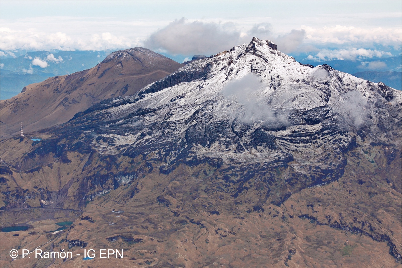
The Colombian Geological Service and the GEOPHYSICAL INSTITUTE OF THE NATIONAL POLYTECHNIC SCHOOL OF ECUADOR closely monitor the evolution of this seismic activity and the volcanic phenomenon and inform in a timely manner about the detected changes.
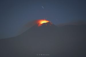
Following the activity of VOLCAN CHILES, the COLOMBIAN GEOLOGICAL SERVICE (SGC) informs that:
Today, December 3, 2018, starting at 1:00 am, the region of Chiles – Cerro Negro volcanoes has shown a new increase in seismicity classified as volcano-tectonic type associated with fractures of cortical material, representing approximately 5,400 events up to the publication of this report. These earthquakes are located southwest of the summit of the Chiles volcano to epicentral distances of 6 km and depths generally less than 8 km from the summit (4700 m altitude). The maximum local magnitude reached by this swarm is 2.3 on the Richter scale. This seismic sequence, which has been the largest in earthquakes since 2015, has been increasing steadily in recent weeks.
The SGC-OVSP and the IGEPN closely monitor the evolution of the volcanic phenomenon and inform in a timely manner about the detected changes, in particular those which indicate a probable eruption.
Source : SGC
Photo : P Ramon / IGEPN.
Hawaii , Kilauea :
19°25’16 » N 155°17’13 » W,
Summit Elevation 4091 ft (1247 m)
Current Volcano Alert Level: ADVISORY
Current Aviation Color Code: YELLOW
Activity Summary:
Kīlauea Volcano is not erupting. Rates of seismicity, deformation, and gas release have not changed significantly over the past week. Deformation signals are consistent with refilling of the middle East Rift Zone.
Observations:
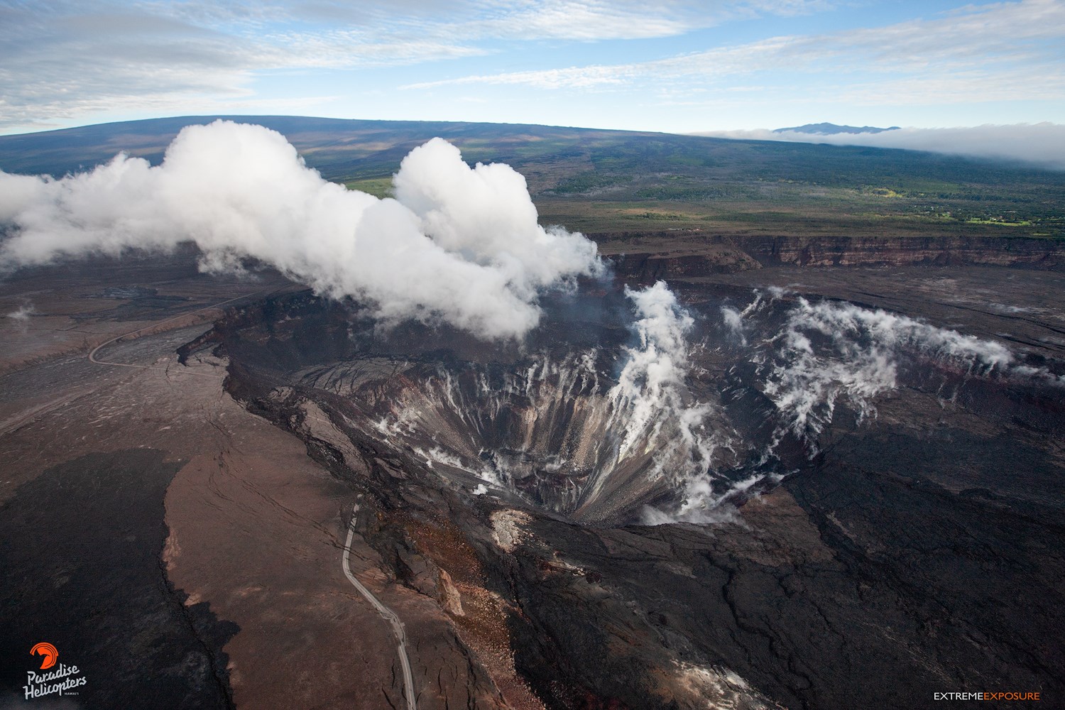
HVO monitoring during the past week shows low rates of seismicity at the summit and East Rift Zone (ERZ). Earthquakes continue to occur primarily at Kīlauea’s summit and south flank areas.
In the ERZ, tiltmeters reveal little change over the last week, with GPS indicating some inflation downrift from Puʻu ʻŌʻō. At the summit, tiltmeters recorded a small DI (deflation-inflation) sequence over the weekend; the current trend is minor deflation.
Sulfur dioxide emission rates have been below detection limits in the LERZ since early September, though minor amounts of volcanic gas are still present. Last week, sulfur dioxide emission rates measured ~35 t/d at the summit as well as ~35 t/d in the ERZ. These most recent measurements are consistent with the extremely low emissions from Kīlauea over the past few months.
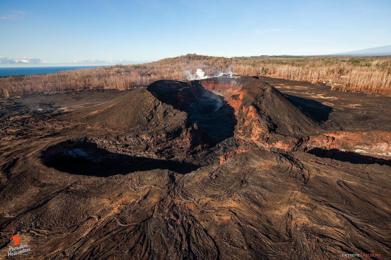
September 4 was the last time active lava was observed along the LERZ; tomorrow (December 5) will mark three months with no eruptive activity at the surface. According to the Smithsonian Institution’s Global Volcanism Program (https://volcano.si.edu/), volcanoes with no eruptive activity over a three-month period are no longer classified as having a « continuing » eruption. Based on this Global Volcanism Program criterion, the LERZ eruption could be considered to be over. However, there is one known example (Mauna Ulu, 1969-74) in which Kilauea’s rift zone activity resumed after more than three months had passed. Although this phase of Kīlauea’s activity has now reached this three-month threshold, it is important to note that it is still an active volcano that could erupt in the near future and associated hazards have not changed. Magma is being supplied to Kīlauea and geophysical datasets continue to show evidence for movement of material through the magma system, including the refilling of the ERZ.
Hazards are still present in the LERZ eruption area and at the Kīlauea summit. Residents and visitors near recently active fissures and lava flows should stay informed, heed Hawaii County Civil Defense and National Park warnings, and be prepared, if necessary, to self-evacuate in the unlikely event of renewed activity. Please note that Hawaii County maintains a closure of the entire flow field and the vents and prohibits access to the area unless authorized through Civil Defense.
The Hawaiian Volcano Observatory (HVO) continues to closely monitor Kīlauea’s seismicity, deformation, and gas emissions for any sign of reactivation, and maintains visual surveillance of the summit and the East Rift Zone. HVO will continue to issue a weekly update (every Tuesday) and additional messages as warranted by changing activity.
Source : HVO
Photos : Bruce Omori / Paradise helicopters
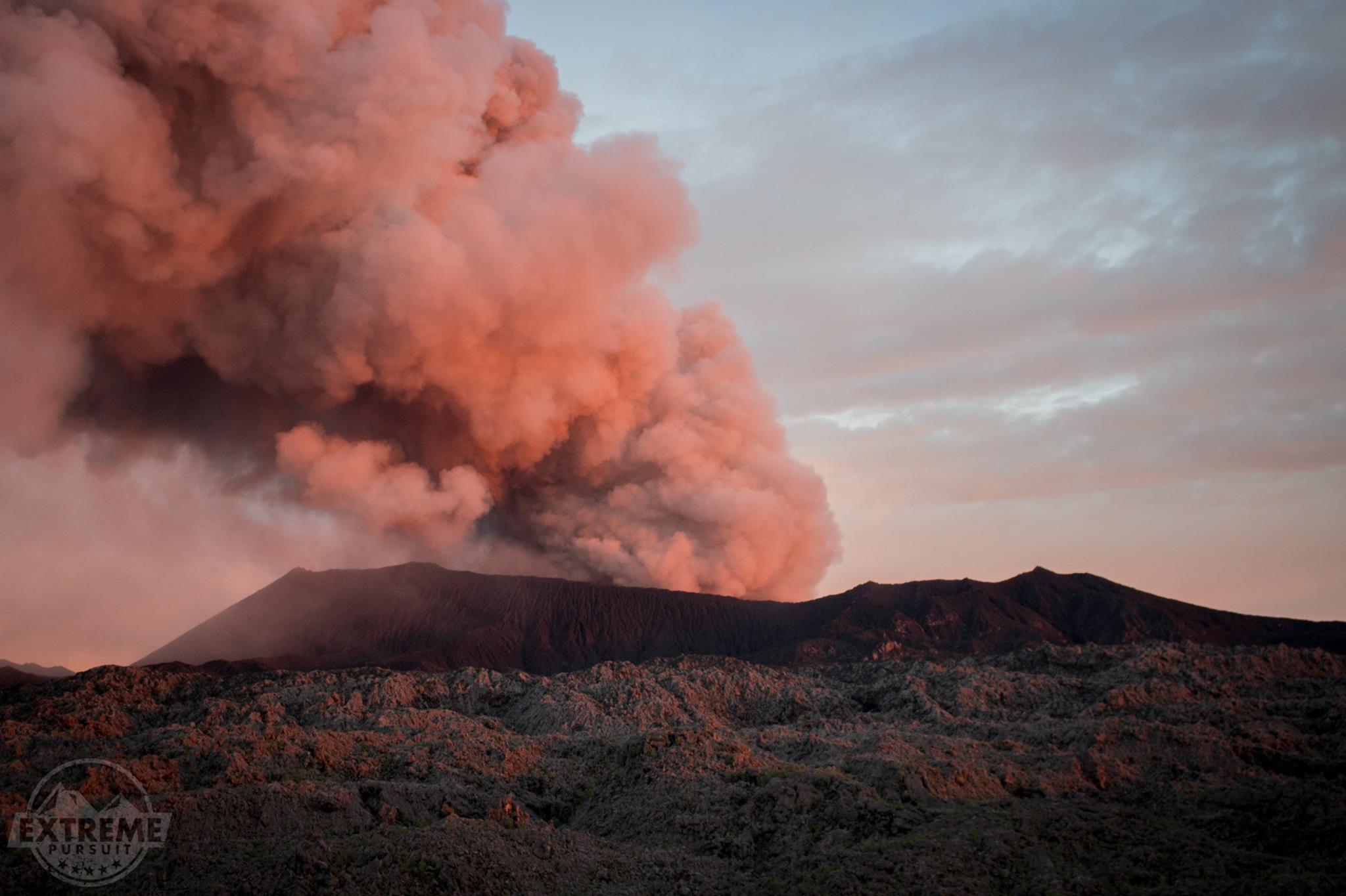
Indonesia , Dukono :
VOLCANO OBSERVATORY NOTICE FOR AVIATION – VONA.
Issued: December 04 , 2018
Volcano: Dukono (268010)
Current Aviation Colour Code: ORANGE
Previous Aviation Colour Code: orange
Source: Dukono Volcano Observatory
Notice Number: 2018DUK212
Volcano Location: N 01 deg 41 min 35 sec E 127 deg 53 min 38 sec
Area: North Maluku, Indonesia
Summit Elevation: 3933 FT (1229 M)
Volcanic Activity Summary:
Eruption with volcanic ash cloud at 23h15 UTC (08h15 local).
Volcanic Cloud Height:
Best estimate of ash-cloud top is around 5213 FT (1629 M) above sea level, may be higher than what can be observed clearly. Source of height data: ground observer.
Other Volcanic Cloud Information:
Ash cloud moving to West.
Remarks:
Eruption and ash emission is continuing.
Activity Level at level II(WASPADA). The Dukono volcano (1229 m above sea level) has continuous eruptions.
Since yesterday and until this morning, the summit of the volcano was covered with fog. It was observed that the smoke from the crater was gray-white with a height of 500 m above the summit when the mountain was discovered. The wind was faintly westerly.
On the seismographs, on December 4, 2018 it was recorded:
2 earthquakes of eruption
5 distant tectonic earthquakes (including the Terasa earthquake at MMI I scale)
A tremor is recorded continuously with an amplitude of 0.5 to 4 mm (dominant value 2 mm)
Recommendation: People around G. Dukono and visitors / tourists should not have activities, climb or approach the Malupang Warirang crater within 2 km.
VONA: The latest ORANGE VONA code was issued on December 1, 2018 at 09:36 AM WIT, related to an eruption with ash column height of approximately 1629 m above sea level or approximately 400 m above the summit. The column of ash was moving to the northwest.
Source : Magma Indonésie.
Photo : Extreme Pursuit.
Italy / Sicily , Etna :
The weak Strombolian activity continues on Etna.
Strombolian activity is noted in « Puttusiddu », as well as in the crater of « Bocca Nuova ».
https://www.facebook.com/giovanni.giusa/videos/1897797733603282/
ETNA NSEC December 3, 2018
The mouth on the east flank of the New Southeast Crater and its cone formed inside.
Extreme closeup of the « conetto » formed in recent weeks in the mouth on the eastern flank of the new crater southeast. This is not a real eruption, but a persistent and light strombolian activity made of ups and downs that has formed only a cone inside the main mouth and a small lava flow. Some images on the Web have clearly misled many people thinking that Etna had erupted, but that is not the case, at least for the moment. These are pictures taken with long exposures or different overlapping shots. Therefore, even if they are very spectacular and suggestive, they do not show reality or what we would see with the naked eye in person.
Commentaires et Video : Gio Giusa .