February 06 , 2023.
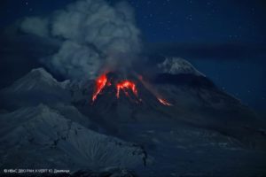
Ecuador , Sangay :
DAILY REPORT OF THE STATE OF SANGAY VOLCANO, Sunday February 05, 2023.
Information Geophysical Institute – EPN.
Surface Activity Level: High, Surface Trend: No change
Internal activity level: High, Internal trend: No change.
Seismicity: From February 04, 2023, 11:00 a.m. to February 05, 2023, 11:00 a.m.:
For seismicity statistics, there are 24 hours of operation at the reference station.
Explosion (XP) 70
Emission Tremors (TREMI ) 25
Long Period (LP): 5
Rains / Lahars:
No rain was recorded **In the event of heavy rains, these could remobilize the accumulated material, generating mudslides and debris that would descend the flanks of the volcano and flow into the adjacent rivers.**
Emission / Ash Column:
In the past 24 hours, the Washington VAAC has not issued any ash emission statements.
Other Monitoring Parameters:
The FIRMS system records 1 thermal alert and MIROVA-VIIRS records 1 high thermal alert (145MW) on the Sangay in the last 24 hours.
Observation:
Due to the cloudiness of the area, there is no observation of surface level activity.
Alert level: Orange.
Source : IGEPN.
Photo : Robinsky
Indonesia , Bromo :
The Center for Volcanology and Geohazard Mitigation (PVMBG) of the Ministry of Energy and Mineral Resources reported on Saturday (4/2/2023) an increase in activity in Mount Bromo crater to the east of Java.
This information is based on the results of visual and instrumental monitoring from the Bromo Volcano Observation Post (PGA) in Cemoro Lawang Hamlet, Ngadisari Village, Sukapura District, Probolinggo Regency, East Java Province.
Until February 4, 2023 at 08:00 WIT, changes to activity on Mount Bromo are as follows:
1. Based on visual observations, there has been an increase in activity within the crater of Mount Bromo in the form of observations of an incandescence from inside the crater based on visual observations the February 3, 2023 at 9:14 p.m. WIB. The smell of sulfur emanated strongly from the rim of the crater and a roar was heard. Over the past week, smoke from the crater has been observed to be white, weak to thick with an elevation of 50 to 900 meters above the summit. Vegetation on the eastern wall of the caldera is yellow and drying out due to exposure to smoke from Mount Bromo’s crater.

2. Seismic observations showed continuous tremors with an amplitude of 0.5 to 1 mm (mainly 0.5 mm), accompanied by deep volcanic earthquakes and shallow volcanic earthquakes. This indicates that there is a process of pressure fluctuations under Mount Bromo accompanied by fluid flow to the surface.
3. The potential danger caused by increased activity in the crater of Mount Bromo is the occurrence of phreatic or magmatic eruptions with the distribution of eruption material in the form of ash and ejected (incandescent) stones up to a radius of 1 km from the center of the crater, as well as the release of gases harmful to life.
Based on the results of a thorough assessment, Mount Bromo’s activity level is still at Level II (WASPADA). The recommendations adapted to the last potential dangers are as follows:
1. Communities around Mount Bromo and visitors/tourists/climbers do not enter the crater area within 1 km of the active Mount Bromo crater.
Source : netralnews.com
Photo : Oystein Lund Andersen.
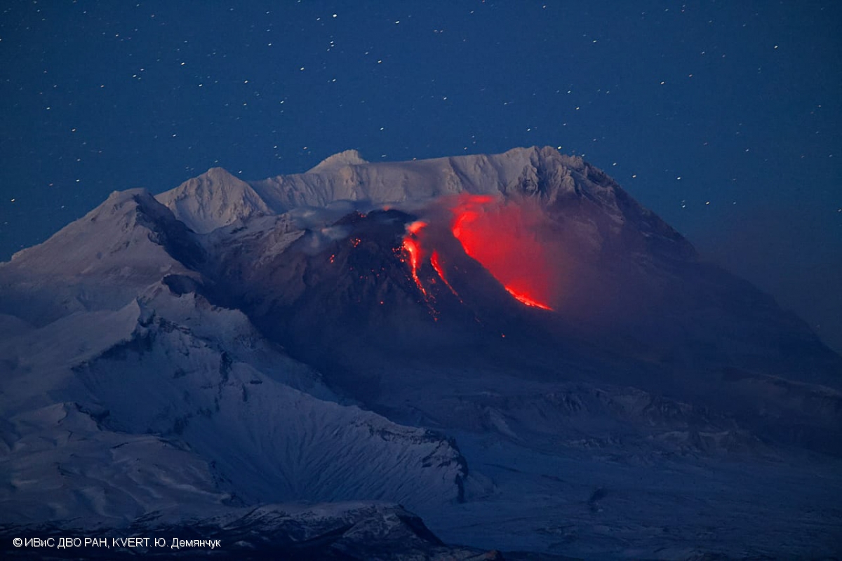
Kamchatka , Sheveluch :
VOLCANO OBSERVATORY NOTICE FOR AVIATION (VONA)
Issued: February 06 , 2023 .
Volcano: Sheveluch (CAVW #300270)
Current aviation colour code: ORANGE
Previous aviation colour code: orange
Source: KVERT
Notice Number: 2023-23
Volcano Location: N 56 deg 38 min E 161 deg 18 min
Area: Kamchatka, Russia
Summit Elevation: 3283 m (10768.24 ft), the dome elevation ~2500 m (8200 ft)
Volcanic Activity Summary:
The growth of the lava dome continues, a strong fumarole activity, an incandescence of the lava dome, sometimes explosions, and hot avalanches accompanies this process. Satellite data by KVERT showed a gas-steam plume contained some amount of ash is drifting to the northnortheast of the volcano.
The extrusive eruption of the volcano continues. Ash explosions up to 10-15 km (32,800-49,200 ft) a.s.l. could occur at any time. Ongoing activity could affect international and low-flying aircraft.
Volcanic cloud height:
5000-5500 m (16400-18040 ft) AMSL Time and method of ash plume/cloud height determination: 20230206/0340Z – Himawari-9 14m15
Other volcanic cloud information:
Distance of ash plume/cloud of the volcano: 68 km (42 mi)
Direction of drift of ash plume/cloud of the volcano: ENE / azimuth 77 deg
Time and method of ash plume/cloud determination: 20230206/0340Z – Himawari-9 14m15
Source : Kvert.
Photo : Yu. Demyanchuk, IVS FEB RAS, KVERT
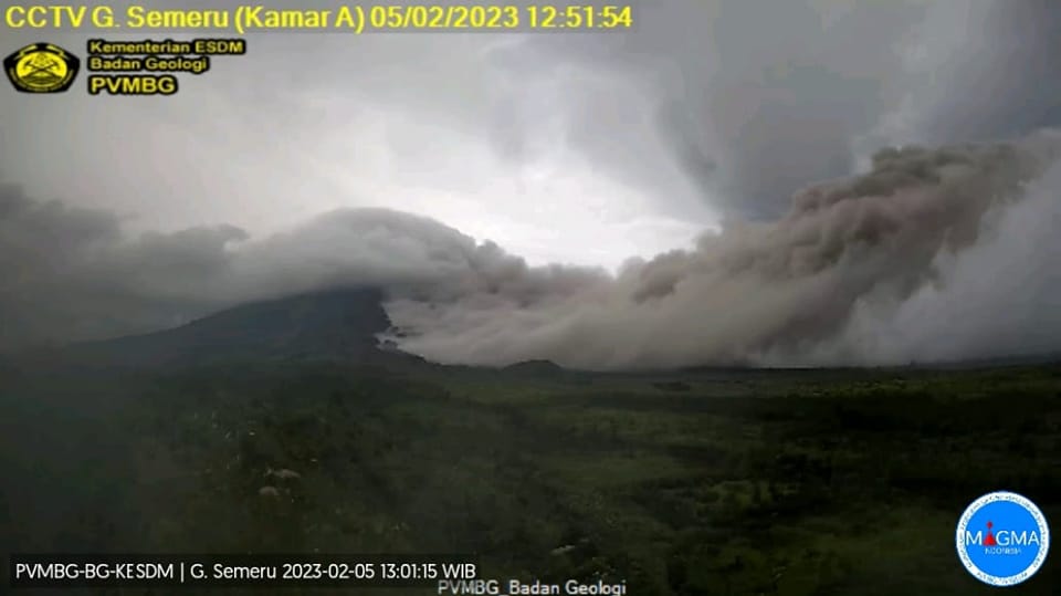
Indonesia , Semeru :
The eruption of Mount Semeru emits hot clouds descending up to 6 kilometers
According to information from the Pusdalops BPBD Lumajang Regency, the APG is heading towards the southeast or into the Kali Lanang region.
The Mount Semeru eruption occurred at 12:42 PM WIB with a column of ash 1,500 meters above the summit.
The ash column was observed to be gray to brown with moderate to thick intensity oriented to the north. So far, the status of Mount Semeru is still at level 3 (SIAGA).
INFORMATION ON THE ERUPTION OF G. SEMERU
There was an eruption from G. Semeru, East Java on February 5, 2023 at 12:42 WIB with an ash column height observed ± 1,500 m above summit (± 5,176 m above sea level). the sea). The ash column was observed to be white, gray to brown with moderate to thick intensity leaning to the north. This eruption was recorded on a seismogram with a maximum amplitude of 22 mm and a duration of ± 15 minutes.
A hot avalanche cloud descended to the South-South-East (Kalilanang), 6 km from the summit
Currently, G. Semeru is in Tier III (SIAGA)* status with the following recommendations:
1. Do not carry out any activity in the Southeast sector along Besuk Kobokan, 13 km from the summit (the center of the eruption). Outside of this distance, the community does not carry out activities within 500 meters of the bank (river edge) along Besuk Kobokan as it has the potential to be affected by cloud expansion. hot and lava flows up to a distance of 17 km from the summit.
2. Do not travel within 5 km of the crater/summit of Mount Semeru as it is subject to the danger of rock throwing (incandescent).
3. Be aware of the potential for hot cloud avalanches (APGs), lava avalanches and lahars along the rivers/valleys descending from the summit of Mount Semeru, especially along Besuk Kobokan, Besuk Bang, Besuk Kembar and Besuk Sat as well as the potential for lahars in the small rivers which are a tributary of the Besuk Kobokan.
Sources : Detik , PVMBG.
Hawaii , Kilauea :
Sunday, February 5, 2023, 11:42 AM HST (Sunday, February 5, 2023, 21:42 UTC)
19°25’16 » N 155°17’13 » W,
Summit Elevation 4091 ft (1247 m)
Current Volcano Alert Level: WATCH
Current Aviation Color Code: ORANGE
Activity Summary:
The summit eruption of Kīlauea Volcano, within Halemaʻumaʻu crater, continued over the past 24 hours. All recent eruptive activity has been confined to the crater. No significant changes have been observed at the summit or in either rift zone.
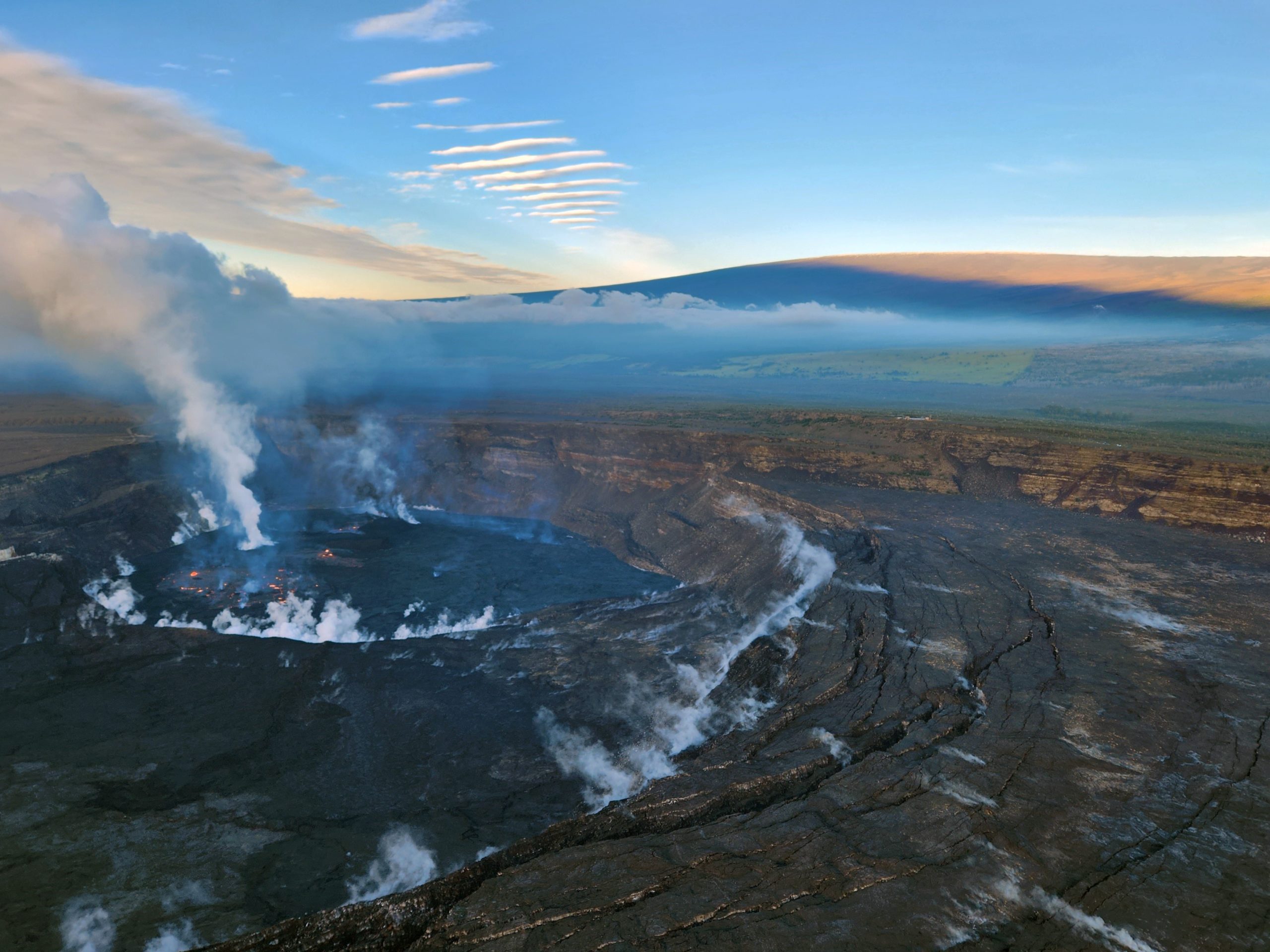
During a Kīlauea summit morning monitoring overflight on February 2, 2023, HVO scientists documented activity in the ongoing Halema‘uma‘u eruption, shown in this photo looking to the SW at 7:30 a.m. HST. Mauna Loa is visible in the background.
Halemaʻumaʻu crater Lava Lake Observations:
Eruption of lava in four locations of Halemaʻumaʻu crater floor continued over the past 24 hours. The eastern lake remains stable and activity within this lake remains about 25 acres in size. The small southern lava fountain within the eastern lake is active and remains at normal heights of 2 m (6 ft) with bursts doubling that height around 4 am HST. A second smaller lava fountain was present in the same area of the lake between 3 am and 7 am HST. The smaller western lake in the basin of the 2021–2022 lava lake as well as the two smaller lava ponds in the central and south portions of the crater floor remain active and unchanged, with no overflows in the past day. A large breakout occurred overnight from 9 pm HST to 9 am HST on the northern portion of the crater floor, equal to or slightly larger in size than the eastern lava lake.
Summit Observations:
Summit tiltmeters have been flat (no inflationary or deflationary trends) over the past day. Volcanic tremor remains above background levels. A sulfur dioxide (SO2) emission rate of approximately 3,000 tonnes per day (t/d) was measured on January 20, 2023.
Source : HVO
Photo : USGS / K. Lynn