September 15 , 2018.
La Réunion , Piton de la Fournaise :
Activity Bulletin from Saturday, September 15, 2018 at 02:00 AM (local time)
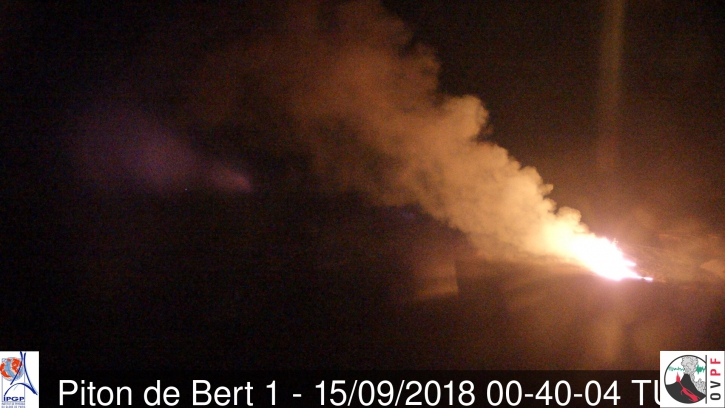
After several hours of progressive segmentation of seismicity, a seismic crisis is recorded on the instruments of the Volcanological Observatory of Piton de la Fournaise since 1:45 local time on September 15. This seismic crisis is accompanied by rapid deformation, This indicates that the magma is leaving the magma reservoir and is spreading to the surface. An eruption is likely in the near future in the next minutes or hours.
Alert level: Alert 1 – imminent eruption
Activity Bulletin from Saturday, September 15, 2018 at 4:35 am (Local time)
Following the seismic crisis started at 1:45 am local time, the volcanic tremor synonymous with the arrival of magma close to the surface is recorded since 4:25 local time.
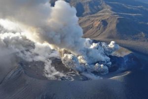
Data analysis and observations from our cameras show that the eruptive fissure (s) opened on the southern flank of the volcano near the crater Rivals.
Eruption in progress.
Alert level: 2-2 Eruption in the Enclos .
Source : OVPF
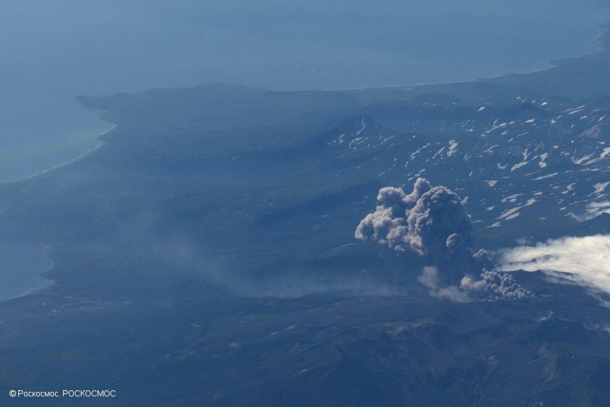
Kamchatka , Ebeko :
50.69 N, 156.01 E;
Elevation 3792 ft (1156 m)
Aviation Colour Code is ORANGE
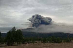
A moderate eruptive activity of the volcano continues. Ash explosions up to 19,700 ft (6 km) a.s.l. could occur at any time. Ongoing activity could affect low-flying aircraft and airport of Severo-Kurilsk.
A moderate explosive activity of the volcano continues. According to visual data by volcanologists from Severo-Kurilsk, explosions sent ash up to 3.4 km a.s.l. on 10-13 September; sometimes an incandescence over the volcano was noting. Satellite data by KVERT showed a thermal anomaly over the volcano on 07, 09 and 12-13 September; ash clouds drifted for about 113 km to the south-east and north-east from the volcano on 10-13 September.
VOLCANO OBSERVATORY NOTICE FOR AVIATION (VONA) .
Issued: September 13 ,2018
Volcano:Ebeko (CAVW #290380)
Current aviation colour code:ORANGE
Previous aviation colour code:orange
Source:KVERT
Notice Number:2018-86
Volcano Location:N 50 deg 41 min E 156 deg 0 min
Area:Northern Kuriles, Russia
Summit Elevation:3791.68 ft (1156 m)
Volcanic Activity Summary:
A moderate explosive activity of the volcano continues. Visual data from Severo-Kurilsk showed an explosion sent ash up to 3.5 km a.s.l., an ash plume is extending to the east from the volcano.
A moderate eruptive activity of the volcano continues. Ash explosions up to 19,700 ft (6 km) a.s.l. could occur at any time. Ongoing activity could affect low-flying aircraft and airport of Severo-Kurilsk.
Volcanic cloud height:
9840-11480 ft (3000-3500 m) AMSL Time and method of ash plume/cloud height determination: 20180913/2046Z – Visual data
Other volcanic cloud information:
Distance of ash plume/cloud of the volcano: 6 mi (10 km)
Direction of drift of ash plume/cloud of the volcano: E
Source : Kvert
Photo : Roskosmos.
Video : KB GS RAS
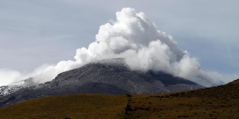
Colombia , Nevado Del Ruiz :
Subject: Activity bulletin of the Nevado del Ruiz volcano.
The level of activity continues at the level: Yellow activity level or (III): changes in the behavior of volcanic activity.
With regard to monitoring the activity of the Nevado del Ruiz volcano, the COLOMBIAN GEOLOGICAL SERVICE informs that:
During the last week, the seismicity caused by the fracturing of the rocks that make up the volcano showed a slight increase in the number of earthquakes and released seismic energy, compared to the previous week. The earthquakes were located mainly in the North proximal, South, Southeast and Arenas crater, at depths between 0.2 and 6.3 km. The maximum magnitude recorded during the week was 1.3 ML (local magnitude) corresponding to the earthquake on September 10 at 7:40 am (local time), located 4.3 km north of Arenas crater, at a depth of 5.9 km.
The seismicity related to fluid dynamics within the ducts of the volcanic structure has shown a decrease in the number of earthquakes and released seismic energy compared to the previous week. This type of seismic activity was characterized by the occurrence of earthquakes of variable energy levels, long period (LP), very long period (VLP), pulses of volcanic tremor and episodes of continuous volcanic tremor. The earthquakes were mainly in the crater Arenas and its surroundings. Some of these seismic signals were associated with lower emissions of gas and ash into the atmosphere, as confirmed by images captured by cameras in the volcano area and by officials of the Colombian Geological Survey and the park. Natural National Los Nevados (PNNN).
Ash falls have been observed not only in the areas surrounding the volcano but also in the city of Manizales and in the municipality of Villamaría (Caldas department). These ash emissions have been reported to the civil aviation industry via VONA notifications (aviation volcano observation notification).

Volcanic deformations measured from electronic inclinometers, Global Navigation Satellite System (GNSS) stations and radar images show until now a stability behavior without recording any important process of deformation of the volcanic structure.
The volcano continues to emit water vapor and gases into the atmosphere, among which is the sulfur dioxide (SO2), as evidenced by the values obtained by the SCANDOAS stations installed in the volcanic region and the satellite image analysis. During the week, no thermal anomalies were reported.
The column of gas and steam reached a maximum height of 1400 m measured at the summit of the volcano on 4 September. The direction of dispersal of the column was governed by the direction of the wind in the area, which during the week predominated to the northwest relative to the crater Arenas.
The Nevado del Ruiz volcano continues its activity at the level of yellow activity.
Source : SGC
Photo : John Jairo Bonilla , El Cronista .
Iceland , Bárðarbunga :
Powerful earthquake in sub-glacial volcano Bárðarbunga
A brief but sharp earthquake swarm was detected in the Bárðarbunga caldera before noon today, Friday. The relatively short swarm, which counted just a handful of quakes, included one relatively powerful 4.2 magnitude quake. According to the seismic monitoring system of the the Icelandic Meteorological Office the epicenter of this quake was in the north eastern part of the volcano’s caldera, at a depth of 1.2 km (0.75 mi). Any earthquake more powerful than 3 on the Richter scale is considered a very significant geological event when it takes place in a volcano, where it is caused by movements of magma.

The Bárðarbunga system has been showing increasing levels of activity for the past year or so, following the 2014-15 Holuhraun eruption at the northern edge of the system. Significant and powerful earthquakes are relatively common in the volcano. Scientists believe the activity is caused by magma being thrusting itself into the magma chambers of Bárðarbunga, readying the volcano for a second eruption. Bárðarbunga has historically erupted in drawn out episodes with shorter pauses in between eruptions.
Source : Icelandmag.
Photo : Tómas Guðbjartsson
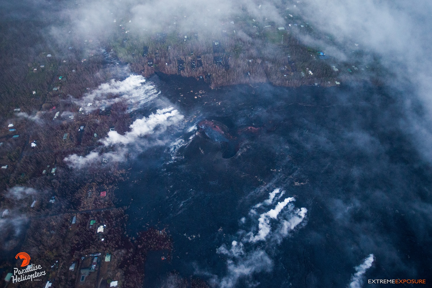
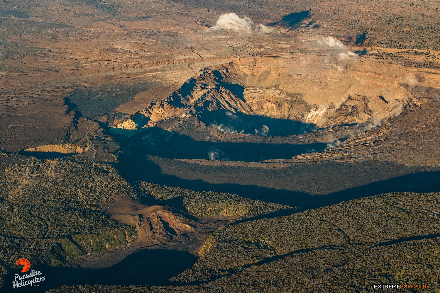
Hawaï , Kilauea :
19°25’16 » N 155°17’13 » W,
Summit Elevation 4091 ft (1247 m)
Current Volcano Alert Level: WATCH
Current Aviation Color Code: ORANGE
Kīlauea summit and lower East Rift Zone
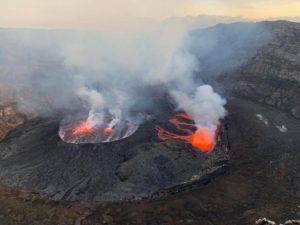
On Kīlauea Volcano’s lower East Rift Zone (LERZ), the collapse pit is the central part of a slowly subsiding lava surface that previously filled the fissure 8 cone. Minor incandescence is still visible overnight while minor fuming is visible during the day. What appeared to be a small slow lava flow yesterday was probably a layer of incandescence that was gradually exposed yesterday morning in the collapse pit. Since the beginning of September, small lava flows have been observed within the fissure 8 cone, however none have extended outside the walls of the cone.
Seismicity and ground deformation remain low at the summit of Kīlauea. Aftershocks from the magnitude-6.9 earthquake in early May are still being generated on faults located on Kīlauea’s South Flank. For the last few days, summit tilt seemed to be turning to weak inflation but weak deflation resumed two days ago (09/12).
Small collapses continue to occur within Puʻu ʻŌʻō crater generating dust plumes. Rates of tilting throughout the East Rift Zone are much lower than were observed during the period of major eruptive activity. There has been no change in seismicity during the past week.
Sulfur dioxide (SO2) emission rates at the summit, Puʻu ʻŌʻō, and LERZ are drastically reduced; the combined rate is less than 1,000 tonnes/day, which is lower than at any time since late 2007. SO2 emission rates from LERZ vents Tuesday (09/11) were below the detection threshold of the measurement technique.
The Hawaiian Volcano Observatory (HVO) continues to closely monitor Kīlauea’s seismicity, deformation, and gas emissions for any sign of reactivation, and maintains visual surveillance of the summit and LERZ. HVO will continue to issue daily updates and additional messages as needed.
Source : HVO
Photos : Bruce Omori
Alaska , Veniaminof :
56°11’52 » N 159°23’35 » W,
Summit Elevation 8225 ft (2507 m)
Current Volcano Alert Level: WATCH
Current Aviation Color Code: ORANGE
Veniaminof continues to erupt, feeding a lava flow that extends about 800 m (0.5 mi) down the south flank of its summit cone. The lava flow is confined to the summit caldera. Images from an FAA Web camera in Perryville recorded incandescence at night throughout the week, when visibility was good, and a gas plume has been visible sporadically, during clear daytime conditions. No significant ash emissions are being produced. Satellite data have shown elevated surface temperatures throughout the week as well, and seismicity remains elevated.
Mount Veniaminof volcano is an andesitic stratovolcano with an ice-filled 10-km diameter summit caldera located on the Alaska Peninsula, 775 km (480 mi) southwest of Anchorage and 35 km (22 mi) north of Perryville. Veniaminof is one of the largest (~300 cubic km; 77 cubic mi) and most active volcanic centers in the Aleutian Arc and has erupted at least 13 times in the past 200 years. Recent significant eruptions of the volcano occurred in 1993-95, 2005, and 2013. These were Strombolian eruptions that produced lava fountains and minor emissions of ash and gas from the main intracaldera cone. During the 1993-95 activity, a small lava flow was extruded, and in 2013, five small lava flows effused from the intracaldera cone over about five months. Minor ash-producing explosions occurred nearly annually between 2002 and 2010. Previous historical eruptions have produced ash plumes that reached 20,000 ft above sea level (1939 and 1956) and ash fallout that blanketed areas within about 40 km (25 mi) of the volcano (1939).
Source : AVO