March 08 , 2018.
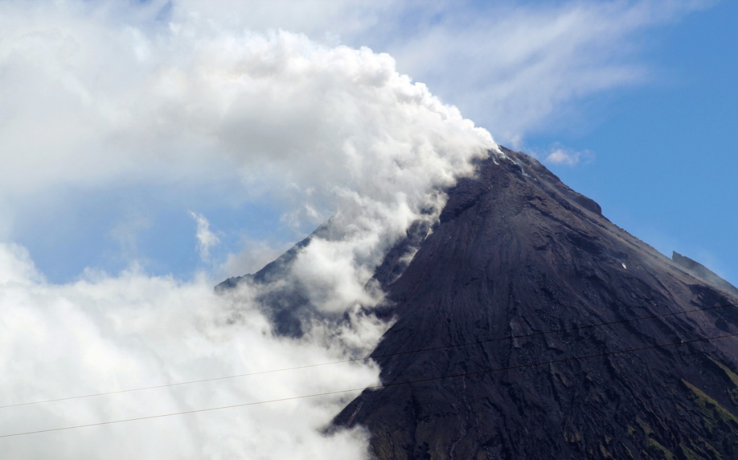
Shinmoedake , Japan :
31.934°N, 130.862°E
Elevation 1700 m
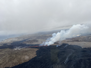
JMA reported that volcanic earthquakes at Shinmoedake (Shinmoe peak), a stratovolcano of the Kirishimayama volcano group, increased during 24-25 February. Volcanic tremor began to be recorded at 08h15 on 1 March and intensified within a few hours. Residents in Takahara-machi, 12 km E (Miyazaki prefecture), reported ashfall at 11h00; poor weather conditions prevented visual observations of the volcano. Later that day a small eruption was confirmed. Ashfall was reported in the Takahara-cho neighborhood, 12 km E (Miyazaki prefecture), around 16h15.
The eruption was observed at 17h07 during an overflight. The sulfur dioxide flux was 5,500 tons/day, but then decreased to 2,200 tons/day on 2 March. During 2-3 March gray ash plumes rose as high as 1 km above the crater, and ash fell in Takahara-cho on 3 March. Ash plumes rose 400 m on 4 March. Explosive events on 6 March generated ash plumes that rose 2.3 km. During an overflight observers noted new lava on the E side of the crater, and plumes rising from both the center of the crater and an area on the N side. Ashfall was confirmed over a wide area from Kirishima prefecture and Kagoshima prefecture to the S, to Miyakonojo city (Miyazaki prefecture) to the E. A high number of volcanic earthquakes continued to be recorded. The Alert Level remained at 3 (on a scale of 1-5).
Source: Agence météorologique japonaise (JMA) , GVP.
Photo : Reuters ( 06/03)
Mayon , Philippines :
MAYON VOLCANO BULLETIN 6 March 2018 8:00 AM
This serves as a notice for the lowering of Mayon Volcano’s status from Alert Level 4 (hazardous eruption imminent) to Alert Level 3 (decreased tendency towards hazardous eruption).
Mayon Volcano’s condition in the past week has been characterized by a general decline in unrest reflected by moderate seismicity and degassing, deflation of the edifice and a decrease in eruptive activity at the summit crater. These observations are supported by the following monitoring parameters:
Activity has diminished to sporadic degassing with associated ash plumes, weak lava fountaining, quiet lava flow and lava collapse, interspersed with two to four days of relative quiescence. The decline in the intensity and frequency of events suggests a gradual depletion of eruptible magma at the shallow levels of the edifice.
Seismic activity has been dominated by low frequency events associated with degassing at the summit and signals of rockfall and small-volume pyroclastic density currents or PDCs generated by the collapsing front and margins of lava flows on the Miisi, Bonga and Basud Gullies and intermediary channels. This is reflected in the diminishing overall seismic energy release from the volcano despite the infrequent occurrence of effusive activity at the summit crater. In the past 24 hours, a total of only four (4) volcanic earthquakes and forty-four (44) rockfall events were recorded by the seismic monitoring network.
Ground deformation data from Precise Leveling (PL) surveys and real-time electronic tilt continue to record deflation of the lower slopes that began on 20 February 2018. The downtrend in ground deformation follows a period of continuous inflation that began in October-November 2017 and indicates a decrease in magma recharge from deep to shallow levels of the edifice. However, based on medium-term PL data, the volcano is still inflated relative to January 2010 baselines.
Measured magmatic sulfur dioxide or SO2 flux throughout the eruption has varied from a maximum of 4,270 tonnes/day on 21 February to 1,400 tonnes/day on 3 March. These concentrations are significantly lower than those measured for past eruptions (e.g. up to >8,000 tonnes/day in 2009) and are consistent with batches of partially degassed magma that have incrementally risen to shallow depths within the edifice. SO2 emission was measured at an average of 2,560 tonnes/day yesterday, 5 March 2018.
In view of the above observations, PHIVOLCS-DOST is lowering the alert status of Mayon from Alert Level 4 to Alert Level 3 to reflect the overall decrease in the level of unrest. Alert Level 3 means that there is a decreased tendency towards hazardous explosive eruption BUT should not be interpreted that unrest has ceased. The volcano can be expected to continue generating volcanic earthquakes, magmatic gas output and weak surface processes such as sporadic degassing and lava effusion events, steam-driven explosions, rockfall and PDCs, while shallow remnant magma rests within the edifice. Should the potential for hazardous explosive eruption be forewarned by an uptrend or pronounced change in monitoring parameters, the Alert Level may be raised back to Alert Level 4. Conversely, should there be a persistent downtrend in monitoring parameters, then the Alert Level will be further lowered to Alert Level 2.
PHIVOLCS-DOST reminds the public that at Alert Level 3, sudden explosions, lava collapses, PDCs and ashfall can still occur and threaten areas in the upper to middle slopes of Mayon.
PHIVOLCS-DOST recommends that entry into the six kilometer-radius Permanent Danger Zone or PDZ and a precautionary seven kilometer-radius Extended Danger Zone or EDZ in the south-southwest to east-northeast sector, stretching from Anoling, Camalig to Sta. Misericordia, Sto. Domingo, must be strictly prohibited. People residing close to these danger areas are also advised to observe precautions associated with rockfalls, PDCs and ashfall. Active river channels and those perennially identified as lahar prone areas in the southern and eastern sectors should also be avoided especially during bad weather conditions or when there is heavy and prolonged rainfall. Civil aviation authorities must advise pilots to avoid flying close to the volcano’s summit as airborne ash and ballistic fragments from sudden explosions and PDCs may pose hazards to aircrafts.
PHIVOLCS-DOST is closely monitoring Mayon Volcano’s activity and any new significant development will be immediately communicated to all stakeholders.
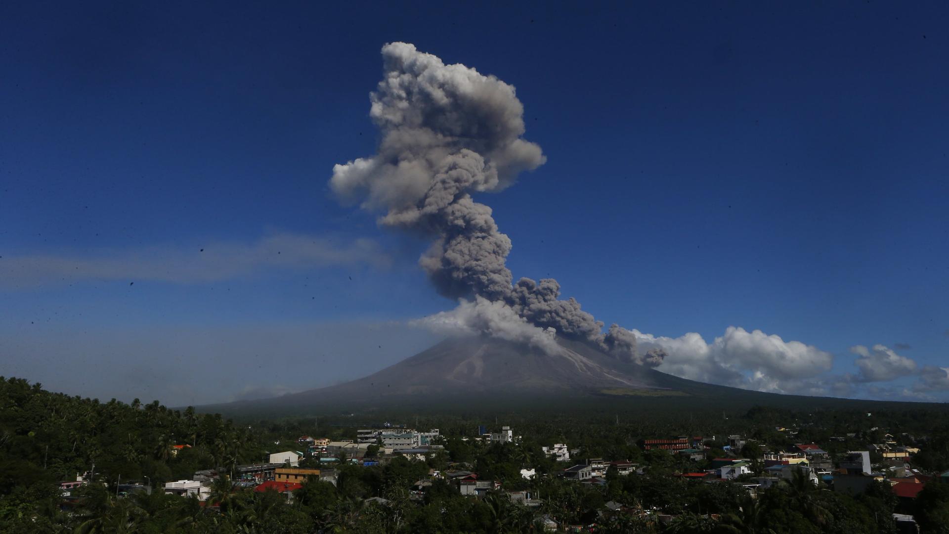
MAYON VOLCANO BULLETIN 08 March 2018 08:00 A.M.
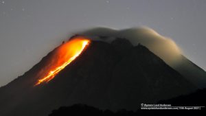
Mayon’s activity in the past 24 hours was characterized by general quiescence, gravity-driven lava flow and degassing from the summit crater. Three (3) events between 05:52 AM and 12:51 PM generated ash plumes that rose 100 to 150 meters above the summit crater before drifting southwest. At night, lava flows were observed to continue moving downslope within 3.3 kilometers, 4.5 kilometers and 1.9 kilometers from the crater on the Miisi, Bonga and Basud Gullies, respectively.
A total of one (1) volcanic earthquake and fifty-three (53) rockfall events were recorded by Mayon’s seismic monitoring network. Sulfur dioxide (SO2) emission was measured at an average of 2,312 tonnes/day on 07 March 2018. Deflation of the lower slopes that began on 20 February is still being recorded by electronic tilt and by Precise Levelling (PL) surveys. Nonetheless, overall ground deformation data indicate that the edifice is still swollen or inflated relative to pre-eruption baselines.
Source : Phivolcs
Photos : Géo , Charism Sayat .
Turrialba , Costa Rica :
Daily activity report of Turrialba volcano:
March 7, 2018
Updated at 11:00 am
Turrialba Volcano: activity over the past 24 hours
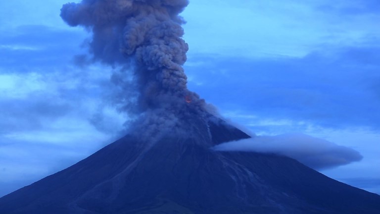
The Turrialba volcano has erupted since March 6 at 11 pm, with ash emissions and columns up to 1000m above the summit of the crater.
The seismic activity presented tremors, which began with the onset of the eruption, with several low-amplitude LP and VT earthquakes.
At the time of this report, the winds at the top of the volcano are heading mainly to the northwest. With influence towards the central valley.

March 7, 2018: After a decrease in seismic activity and degassing observed in recent days, the Turrialba enters again into a strombolian eruptive phase with the emission of gas, ash and incandescent fragments of fresh lava from 00:00 and until the early hours of the morning of March 7, 2018.
Source : Ovsicori
Descabezado Grande, Chile :
Special Report on Volcanic Activity (REAV)
Maule Region, Volcán Descabezado Grande
March 5, 2018,14: 38 local time (Continental Chile)
The National Geological and Mining Service of Chile (Sernageomin) publishes the following PRELIMINARY information, obtained through the monitoring equipment of the National Volcanic Monitoring Network (NVRN), processed and analyzed at the Volcanological Observatory of the Andes of South (OVDAS):
On Monday, March 5, at 11:15 local time, the monitoring stations installed in the vicinity of the volcano recorded an earthquake associated with rock fracturing (volcano-tectonic type), with an epicenter located 12 km northwest of the main crater .
The characteristics of the earthquake after its analysis are as follows
TIME OF ORIGIN: 11.15 local time (14.15 GMT)
LATITUDE: 35.580 ° South
LONGITUDE: 70.761 ° West
DEPTH: 2.7 km
LOCAL MAGNITUDE: 3.7 (ML)
OBSERVATIONS:
At the time of publication of this report, 6 other events of similar localization and local magnitude lower than M3.0 have been recorded.
Volcanic Technical Alert Remains at Level: Warning Level GREEN
Sernageomin monitors the country’s volcanic activity online and informs on a timely basis of any changes.
Source : Sernageomin
Sabancaya , Peru :
Explosive activity decreased, averaging 12 explosions a day. Earthquakes associated with fluid movements (long period type) and ash emissions (Tremor) continue to predominate. The earthquakes associated with the rise of the magma (hybrid types) remain low in number and energy.
The eruptive columns of gas and ash reached a maximum height of 2000 m above the crater. The dispersion of these materials occurred within a radius of approximately 30 km, mainly in the northwest, west and southwest directions.

Deformation tracking shows component stabilization over last week.
The volcanic gas flow (SO2) recorded on 03 March reached a maximum value of 2440 tons / day, a value considered large.
No thermal anomalies were recorded according to the MIROVA system.
In general, eruptive activity maintains moderate levels. No larger variations are expected during the week.
Source : IGP.