July 29 , 2018.
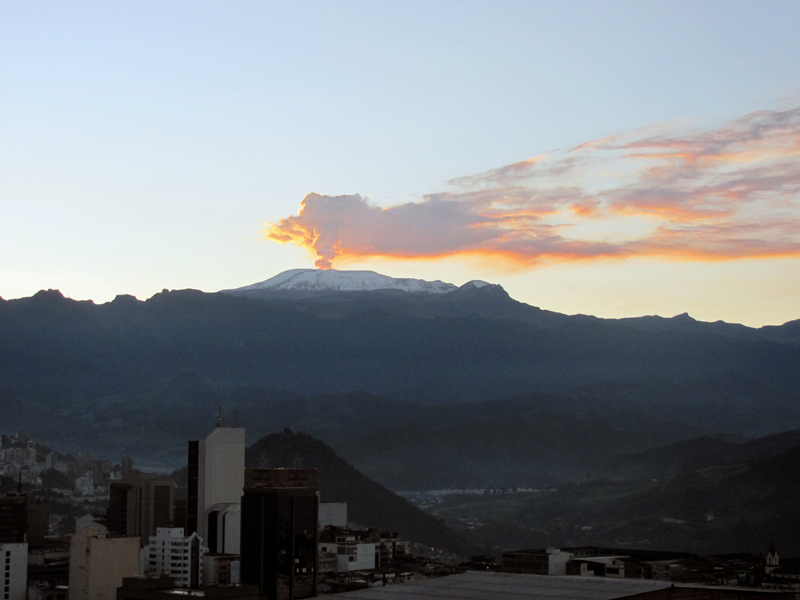
Colombia , Nevado del Ruiz :
Subject: Bulletin of activity of the Nevado del Ruiz volcano.
The level of activity continues at the level: Activity level Yellow or (III): changes in the behavior of volcanic activity.
With regard to monitoring the activity of the Nevado del Ruiz volcano, the COLOMBIAN GEOLOGICAL SERVICE informs that:
During the last week, the seismicity caused by the fracturing of the rocks that make up the volcano showed a slight decrease in the number of earthquakes and an increase in seismic energy released, compared to the previous week. The earthquakes were located in the North-East, South-West, South and South-East areas of the volcano, as well as in the Arenas crater, at depths between 0.8 and 6.3 km. The maximum magnitude recorded during the week was 1.7 ML (Local Magnitude) corresponding to the 18 July earthquake at 0518 local time, located 3.1 km north-east of the Arenas crater, at a depth of from 1.9 km.
The seismic activity associated with fluid dynamics within the channels of the volcanic structure showed a decrease in the number of earthquakes and released seismic energy, compared to the previous week. This type of activity was mainly characterized by the occurrence of long period, very long period and volcanic tremors. The earthquakes were mainly located in the crater of Arenas and its surroundings. On July 22, a volcanic tremor pulse was recorded, associated with a lower emission of gas and ash, confirmed by the cameras installed in the volcano area.
The volcanic deformation measured from electronic inclinometers, Global Navigation Satellite System (GNSS) stations and radar images, has so far shown stability behavior without recording significant deformation processes of the volcanic structure.
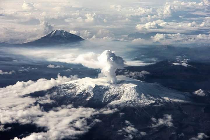
The volcano continues to emit water vapor and gases into the atmosphere, among which sulfur dioxide (SO2) is distinguished, as evidenced by the values obtained by the SCANDOAS stations installed on the volcano, and the analysis of satellite images, which showed an increase during the last evaluation periods. In tracking information provided by the portals of NASA, FIRMS and MIROVA, no thermal anomalies were recorded during this week.
The column of gas and steam reached a maximum height of 400 m measured at the top of the volcano on July 20. The direction of the dispersion of the column was governed by the direction of the wind in the zone, which during the week prevailed towards the West – Northwest relative to the crater Arenas.
The Nevado del Ruiz volcano continues at the Yellow activity level.
Source : SGC.
Hawai , Kilauea :
Saturday, July 28, 2018, 10:16 AM HST (Saturday, July 28, 2018, 20:16 UTC)
19°25’16 » N 155°17’13 » W,
Summit Elevation 4091 ft (1247 m)
Current Volcano Alert Level: WARNING
Current Aviation Color Code: ORANGE
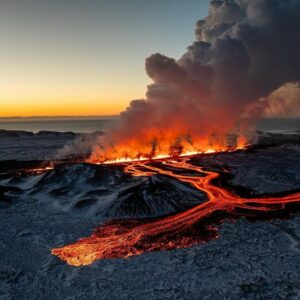
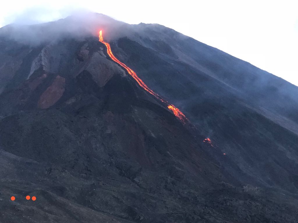
Kīlauea Volcano Lower East Rift Zone
Fissure 8 continues to erupt lava into the channel leading northeastward from the vent. A few small overflows were reported this morning hours after the summit explosion-collapse event. At the coast, the south edge of the lava flow has not advanced westward in the past day, and remains less than 175 m (0.1 mi) from the Pohoiki boat ramp in Isaac Hale Park. The active ocean entry is a few hundred meters (yards) to the east of this lava flow edge.
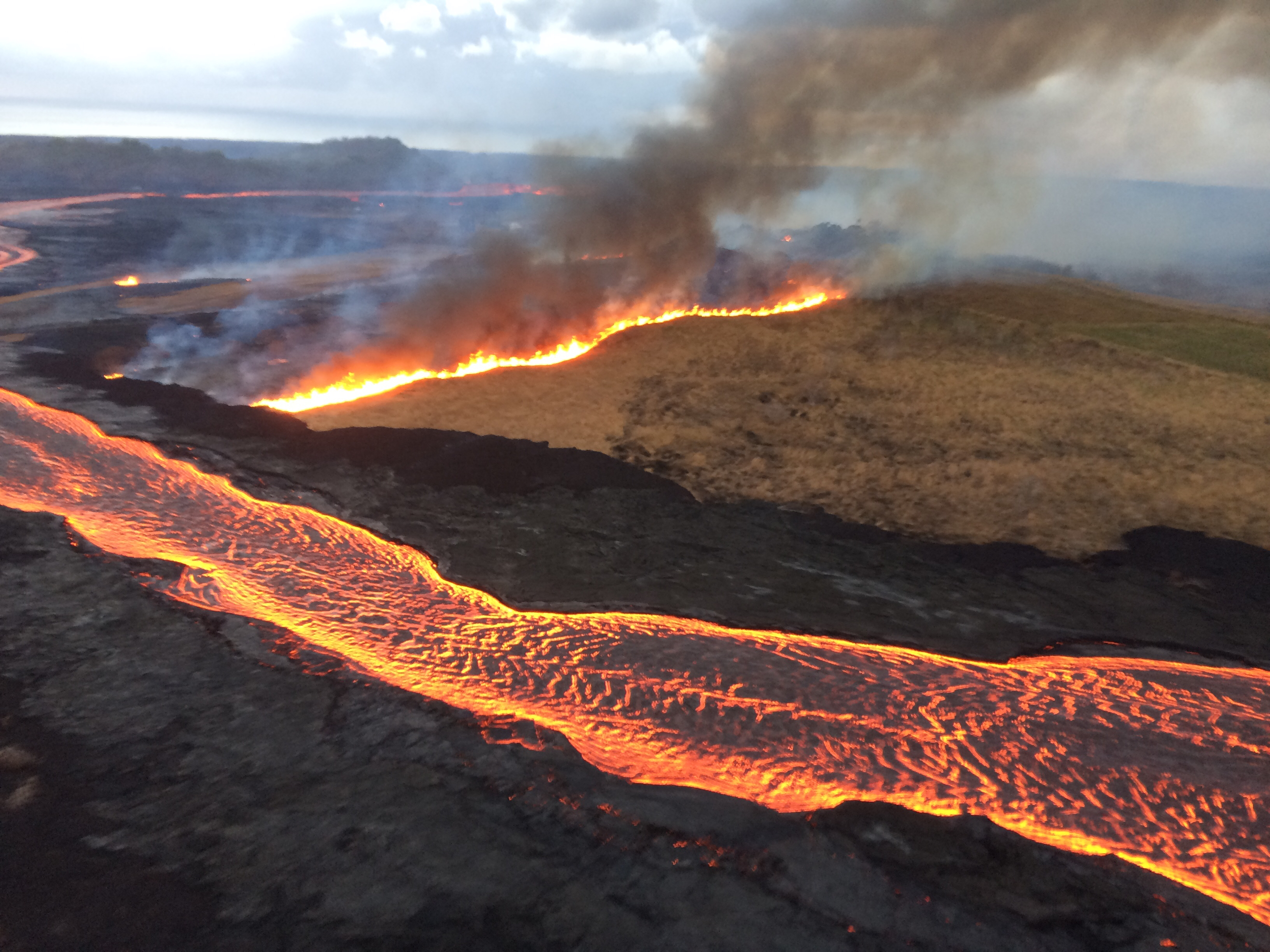
Overflows from the fissure 8 lava channel may have ignited this fire (producing dark smoke) on Halekamahina, an older cinder-and-spatter cone to the west of Kapoho Crater.
No other fissures are active this morning.
Kīlauea Volcano Summit
The most recent collapse event occurred at 02:37 a.m. HST July 28, and was similar in character and magnitude to previous events; the time intervals between the last three collapse events were about 53.5 and 38.5 hours). Seismicity is slowly increasing since this morning’s collapse event.
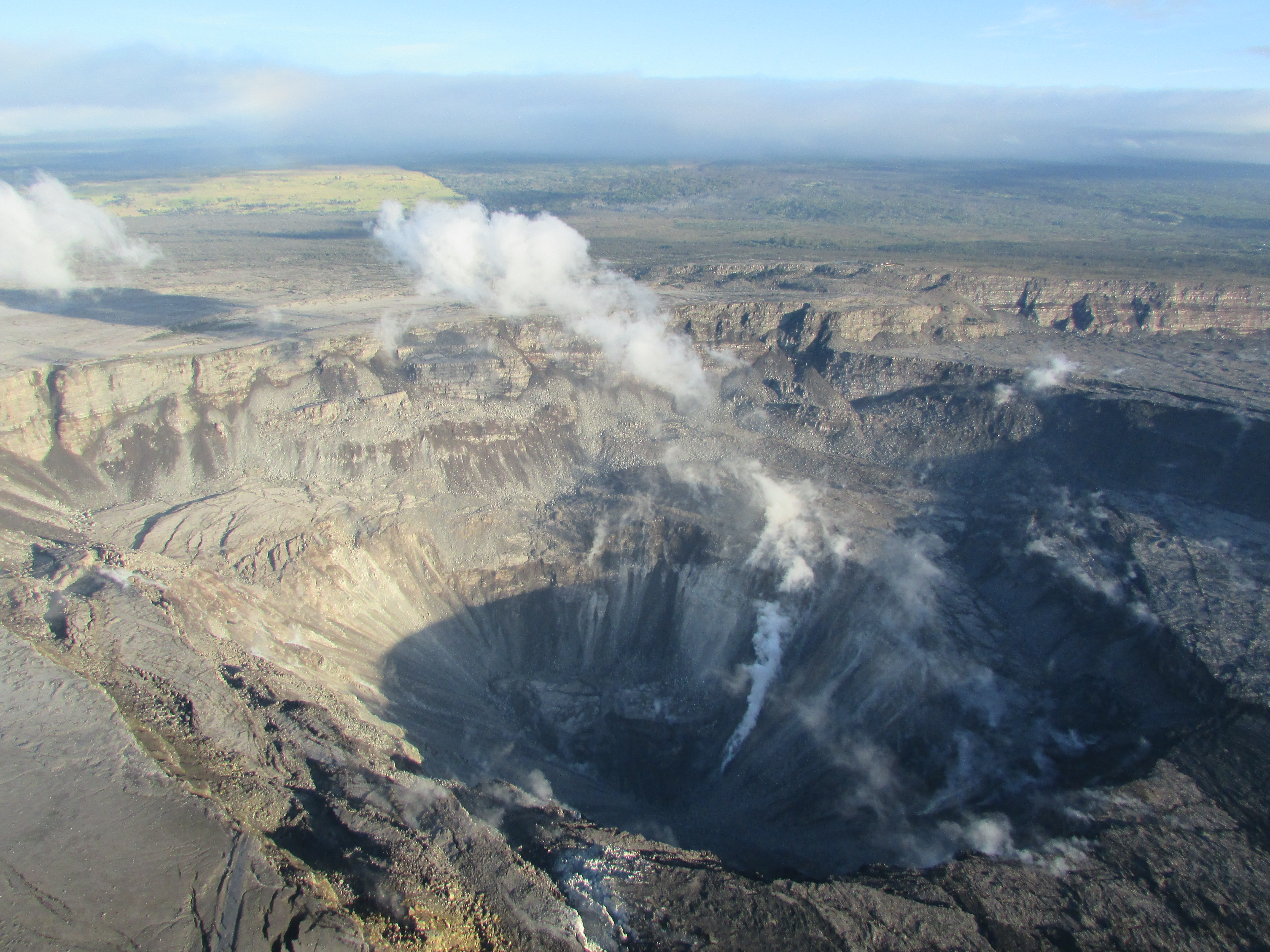
Aerial view of the summit crater from this morning’s overflight. Zoom in to see HVO and the Park’s Jaggar Museum on the caldera rim (right side of photo).
Source : HVO .
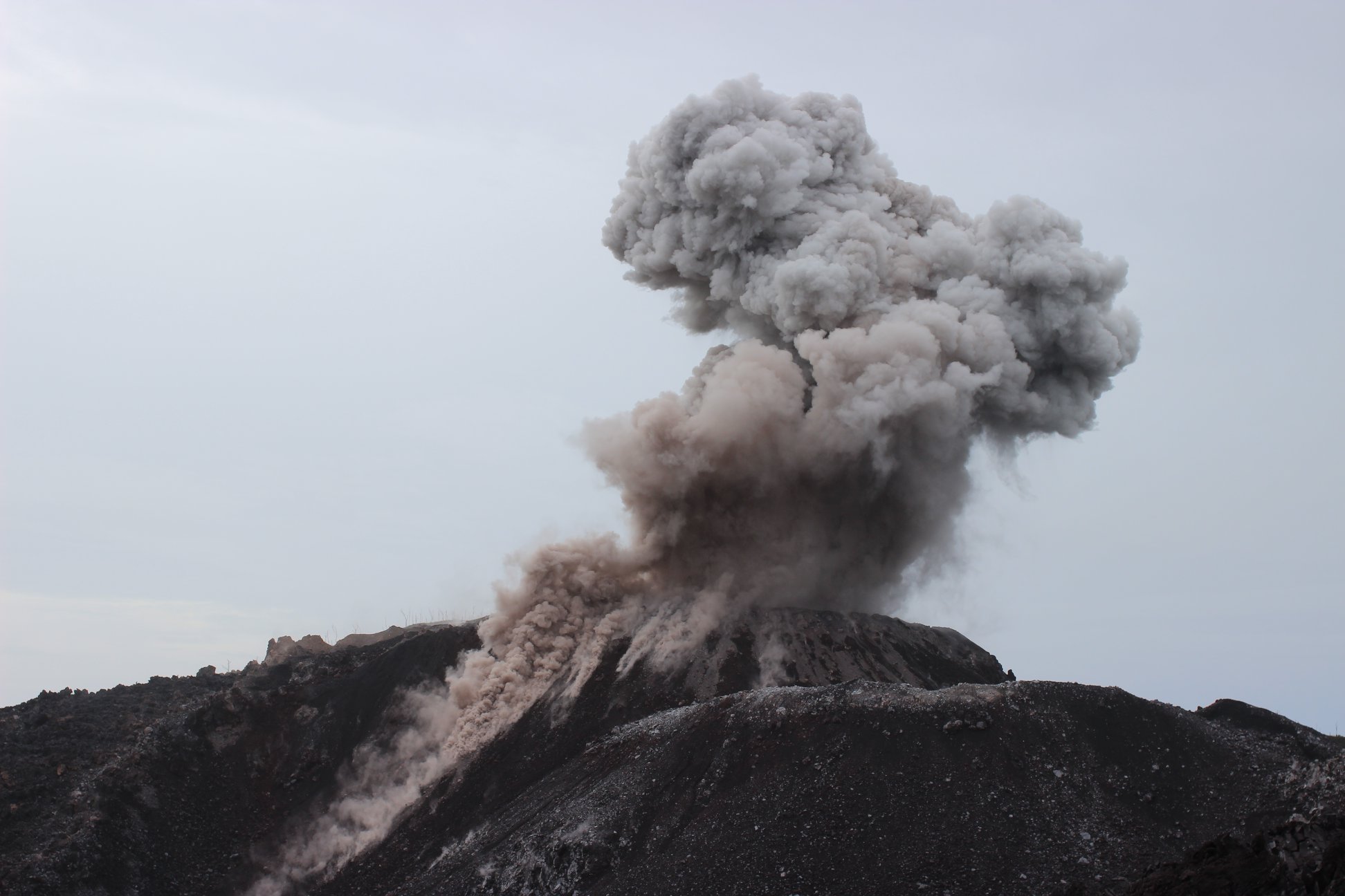
Guatemala , Pacaya :
Type of activity: Strombolian.
Morphology: Stratovolcano Composite
Location: 14 ° 22’50˝ Latitude N; 90 ° 36’00˝ Longitude W.
Height: 2,552msnm.
Weather Conditions: Partly Cloudy
Wind: South
Precipitation: 0.0 mm
Activity:
Presence of white and blue, moderate, low-level fumaroles dispersed to the south. During the night, strombolian explosions are observed which emit incandescent materials at a low height. The lava flow in the direction of Cerro Chino has a length of about 150 meters.. The seismic station records an internal tremor associated with constant degassing and explosions that are generated in the area.
Source : Insivumeh.
Indonesia , Ibu :
VOLCANO OBSERVATORY NOTICE FOR AVIATION – VONA.
Issued: July 28 , 2018.
Volcano: Ibu (268030)
Current Aviation Colour Code: ORANGE
Previous Aviation Colour Code: orange
Source: Ibu Volcano Observatory
Notice Number: 2018IBU10
Volcano Location: N 01 deg 29 min 17 sec E 127 deg 37 min 48 sec
Area: North Maluku, Indonesia
Summit Elevation: 4240 FT (1325 M)
Volcanic Activity Summary:
Eruption with volcanic ash cloud at 09h52 UTC (18h52 local).
Volcanic Cloud Height:
Best estimate of ash-cloud top is around 6800 FT (2125 M) above sea level, may be higher than what can be observed clearly. Source of height data: ground observer.
Other Volcanic Cloud Information:
Ash cloud moving to Southeast.
Remarks:
Seismic activity is characterized by explosion and rock avalanches earthquake.
Level II Activity Level (WASPADA). G. Ibu (1340 m above sea level) has erupted continuously since 2008. Since yesterday until this morning visually the summit of the volcano can be observed clearly until it is covered with fog. Emission / eruption columns from the crater are white to gray, low to medium pressure, and light to moderate intensity with a height of 200 to 800 m above the summit. The wind is weak to medium east and southeast.
According to the seismograph, dated July 28, 2018, it was recorded:
113 earthquakes of eruption
129 emission earthquakes
45 avalanche earthquakes
4 distant tectonic earthquakes
Recommendations:
The communities around G. Ibu and visitors / tourists should not have activities, climb and approach within a radius of 2 km from the crater, with a sectoral expansion of 3.5 km towards the opening in the party North of the active crater of G. Ibu
Source : Magma Indonésie , PVMBG.
Photo : Inconnu.
Italy / Sicily , Etna :
News from the Sicilian giant. By Boris Behncke :
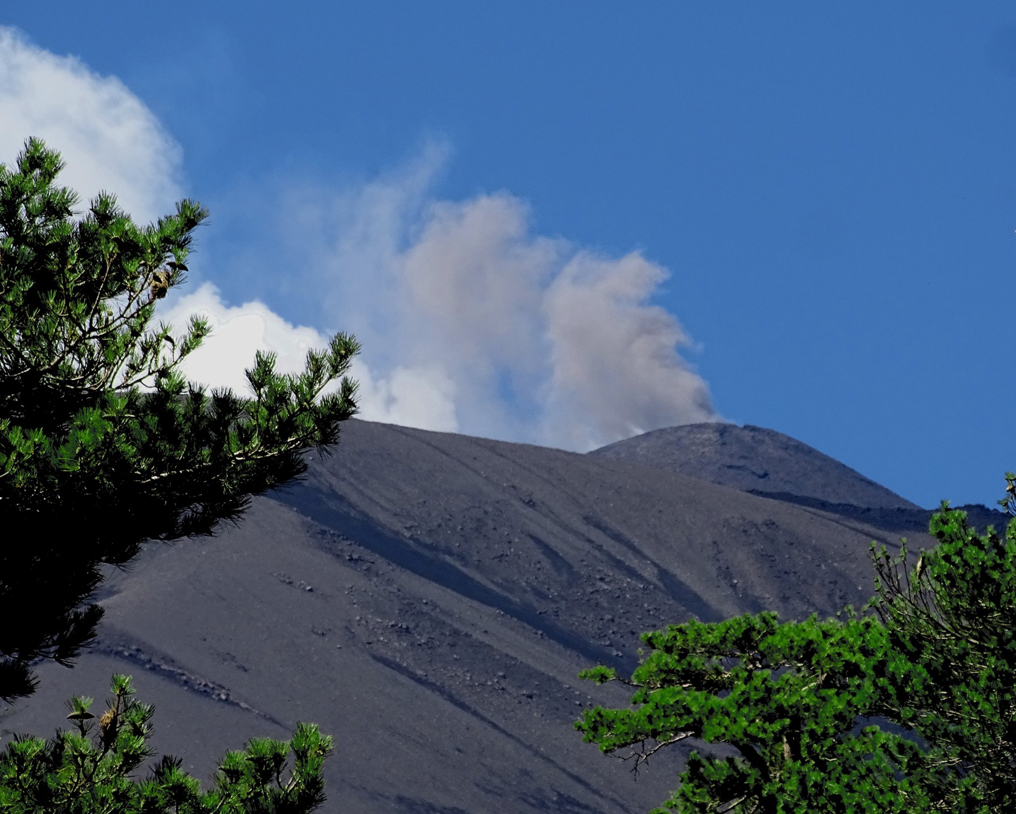
In recent weeks, the crater Northeast produces these ash emissions (in addition to the Strombolian activity documented in recent days). Here is the view of Piano Provenzana, July 28, 2018.
Source : Dr Boris Behncke