February 09 , 2024.
Iceland , Reykjanes Peninsula :
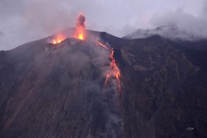
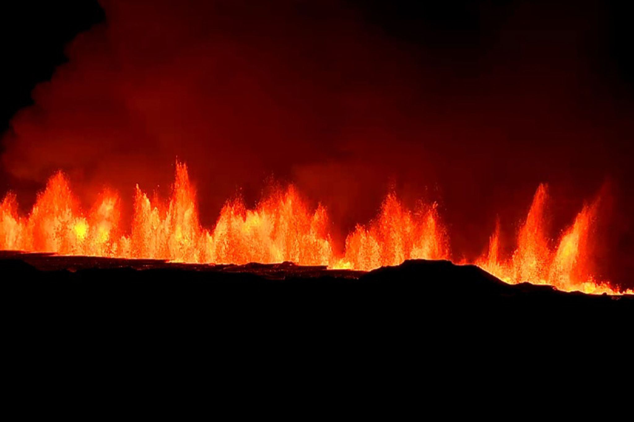
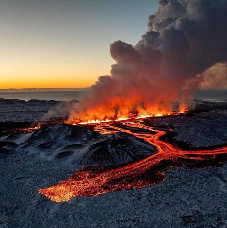
A volcanic eruption has started at the Sundhnúksgígar crater row
Updated 8. February at 12:20
Geodetic data suggest that deformation has decreased significantly in the dyke area. Therefore, probability of new eruptive fissure openings has decreased.
IMO has received notifications of tephra fall in Grindavík.
Tephra is forthy and vesicular material which forms when splashes of lava cool quickly in the air in the lava fountaining activity. This process took place when an eruptive fissure opened this morning (8th of February 2024). Due to the tephras‘ vesicularity and lightness it can be transported far within the volcanic plume with wind. It falls in Grindavík now, 3-5 km from the source of formation due to the height of the lava fountains, north-easterly wind-direction, thermal upwelling from the lava and low air temperature.
Gas dispersion
Weather forecast for gasdispersion from the volcanic site is north-easterly winds, 4-8 m/s today (Thursday), thus gas is dispersed towards south-west. Decreasing wind speed tonight which can cause gas concentrations to build up at the volcanic site. Easterly and south-easterly winds, 5-10 m/s after noon tomorrow (Friday), causing gas to be dispersed to the west and north-west, towards Keflavík.
Updated 8. February at 11:40
The Icelandic Met Office has updated the hazard map for the area. The hazard level has increased in all areas due to the eruption.
Updated 8. February at 14:25 UTC
The vigor of the eruption is decreasing. The activity is now mainly on 3 locations on the eruptive fissure which opened this morning. This is not unlike the process observed in the eruption 18th of December 2023, when the activity was confined to a few craters few hours after the onset of the eruption.
A conspicuous, dark plume rises from one part of the eruptive fissure. This is likely due to magma interaction with groundwater which results in a slight explosive activity where white plume of steam mixes with dark volcanic plume.
It seems that tephra does not travel far from the eruptive fissure at the moment. The volcanic plume is dispersed towards south-west.
Vigor of the eruption decreases significantly. Satellite image shows that lava flowed furthest about 4.5 km to the west from the eruptive site
Updated 8. February at 17:15 UTC
The vigor of the eruption continues to decrease. The eruptive activity is currently on two or three locations on the eruptive fissure. The explosive activity which began between 13 and 14 o‘clock is now mostly over, but minor convective clouds rise from some parts the fissure.
Synchronously with the decreasing vigor of the eruption, the deformation signals detected at the dyke area diminished, indicating that magma is no longer ascending under as much pressure as before. Soon after the onset of the eruption, seismic activity decreased significantly and has remained minor thus far. About 20 small earthquakes have been detected over the dyke since 08:00 this morning.
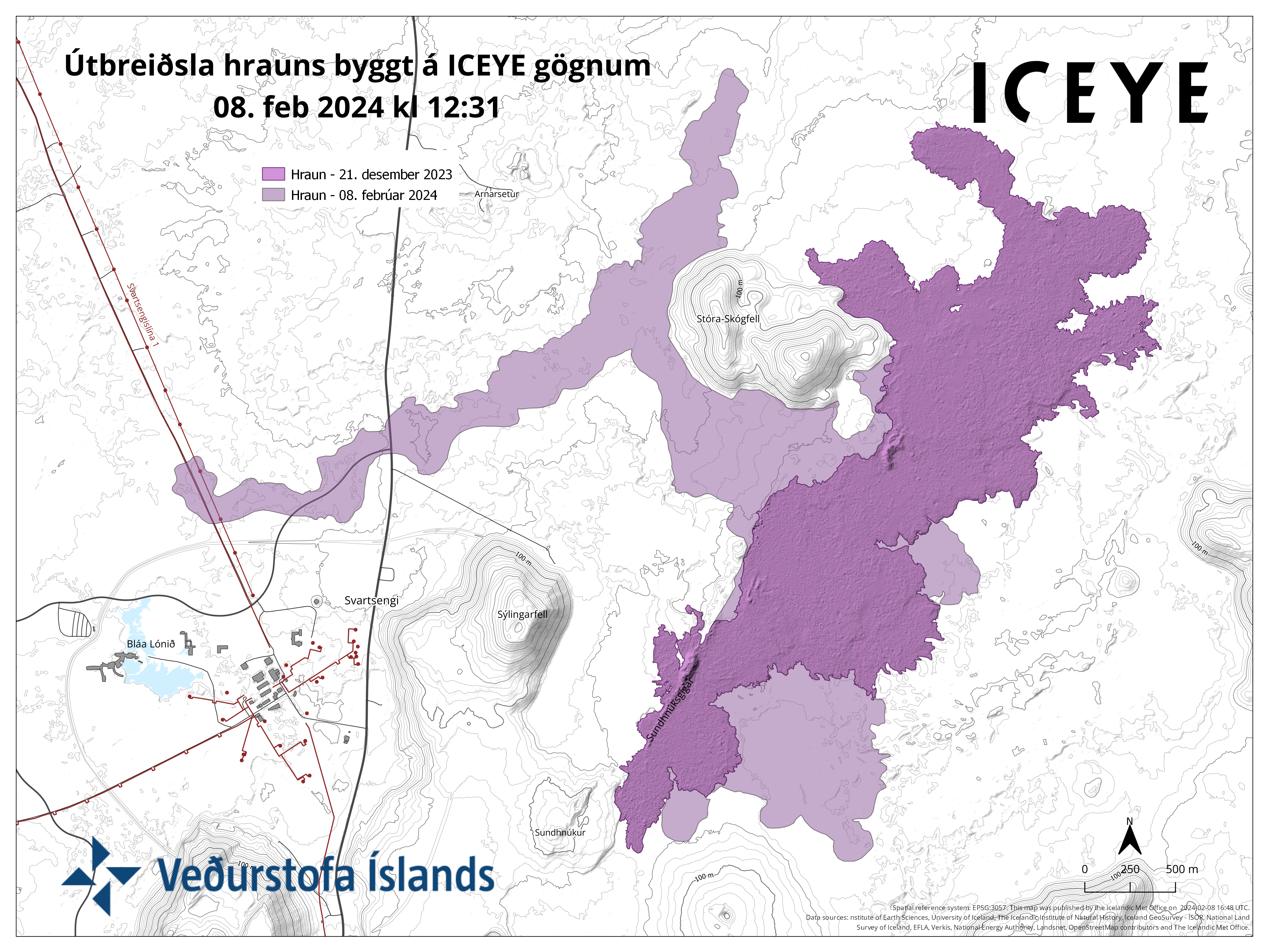
The map shows outlines of the lava flow as it was seen on a satellite image taken at 12:31 today (Thursday 8th- of February). The satellite image shows that lava flowed furthest about 4.5 km to the west from the eruptive site. For comparison, the lava flow field which formed in the eruption on the 18th of December 2023 is also shown on the map. Today ‘s lava flows partly over the lava flow formed in December 2023.
Source : IMO
Photos : Auteur inconnu via Objectif volcans /FB , Krzysztof Baraniak Fotografia , IMO.
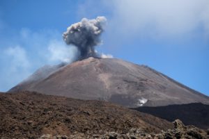
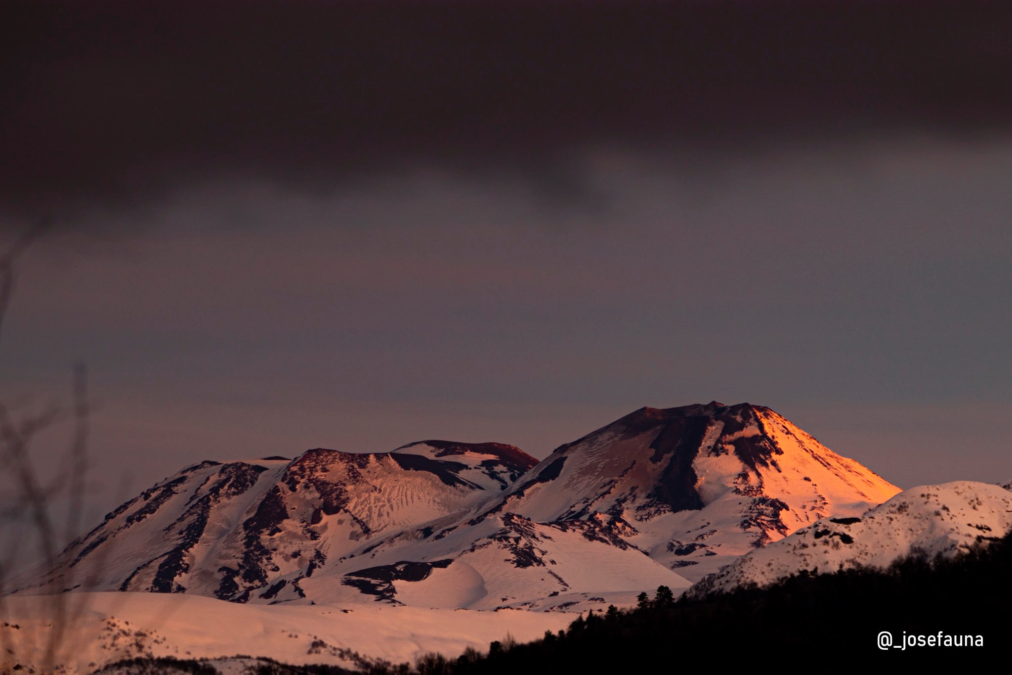
Chile , Nevados de Chillan :
Seismology
The seismological activity of the period was characterized by the recording of:
193 seismic events of type VT, associated with the fracturing of rocks (Volcano-Tectonics). The most energetic earthquake had a Local Magnitude (ML) value equal to 3.0, located 2.6 km south-southeast of the volcanic edifice, at a depth of 4.9 km from the crater .
7 LP type seismic events, associated with fluid dynamics inside the volcanic system (Long Period). The size of the largest earthquake evaluated from the Reduced Displacement (RD) parameter was equal to 2.6 cm2.
1 HB type seismic event, associated with both rock fracturing and fluid dynamics within the volcanic system (Hybrid). The size of the earthquake evaluated from the Reduced Displacement (RD) parameter was equal to 1.2 cm2.
2 VLP type seismic events, associated with the dynamics of large volumes of fluids inside the volcanic system (Very Long Period). The size of the largest earthquake evaluated from the Reduced Displacement (RD) parameter was equal to 2.3 cm2.
Fluid geochemistry
No data on sulfur dioxide (SO2) emissions were recorded due to unfavorable weather conditions and low outgassing. No anomalies have been reported in atmospheric SO2 emissions in the area near the volcanic complex, according to data published by the Tropopheric Monitoring Instrument (TROPOMI) and the Ozone Monitoring Instrument (OMI) Sulfur Dioxide Group.
Thermal anomalies by satellites
No thermal anomalies were reported according to the observation of volcanic activity in the mid-infrared (MIROVA), nor any radiance anomalies according to the analytical processing of Sentinel 2-L2A satellite images in combination of false color bands.
Geodesy
Geodetic activity was characterized by small-scale displacements and deformation rates not exceeding 0.35 cm/month in the vertical components and 0.55 cm/month in the horizontal components. In conclusion, there is no evidence of deformation of the volcanic system for the period evaluated.
Surveillance cameras
The images provided by the fixed camera, installed near the complex, did not record degassing columns or variations linked to surface activity.
Activity remained at levels considered low, suggesting stability of the volcanic system. The technical volcanic alert is maintained in:
GREEN TECHNICAL ALERT: Active volcano with stable behavior – There is no immediate risk
Source : Sernageomin
Photo : Josefauna .
Colombia , Puracé – Los Coconucos Volcanic Range :
Weekly activity bulletin of the Puracé volcano – Los Coconucos volcanic chain
From the monitoring of the activity of the PURACE VOLCANO – LOS COCONUCOS VOLCANIC CHAIN, the MINISTRY OF MINES AND ENERGY, through the COLOMBIAN GEOLOGICAL SERVICE (SGC), reports that:
During the week between January 30 and February 5, 2024, seismic activity presented levels comparable to those of the previous week, both in energy and in number of events.
The fracture earthquakes were located mainly under the edifice of the Puracé volcano, with depths less than 4 km and magnitudes less than 1; while the fluid-associated earthquakes were located in two areas, one under the crater of the volcano with depths less than 1 km and another south of it at depths between 1.5 and 5 km .
Likewise, localized deformations continued to be recorded between the Puracé and Curiquinga volcanoes. Carbon dioxide (CO2) values continue to oscillate and remain above reference values on this volcano. On the other hand, stable values were recorded in the sulfur dioxide (SO2) flux.
The images obtained using the installed cameras show that high degassing of the volcanic system is maintained, both inside the crater and in the external lateral fumarole (northwest flank of the volcanic edifice).
The other parameters measured and used for the diagnosis of volcanic activity showed no notable changes during the period evaluated.
The alert status for volcanic activity remains at: YELLOW ALERT: ACTIVE VOLCANO WITH CHANGES IN THE BEHAVIOR OF THE BASE LEVEL OF MONITORED PARAMETERS AND OTHER MANIFESTATIONS.
Source et photo : SGC.
Costa Rica , Poas :
Latitude: 10.2
Longitude: -84,233
Altitude: 2,687 meters above sea level
Activity observed:
Over the past 24 hours, no significant eruptions have been recorded, only geyser or bubbling events, less frequent since last night, probably attributed to the change in wind direction. The background tremor remains continuous and intense in amplitude, with a frequency spectrum between 1.5 and 6 Hz. Frequent long-period (LP) signals are recorded. Yesterday’s SO2 flux averaged 490 tonnes/day based on DOAS measurements. The CO2/SO2 ratios remain low and H2S/SO2 remain stable. The SO2 concentration remains high with maximum values of 22 ppm. SO2 concentrations at the visitor viewpoint were high (>7 ppm) during the morning. Contraction and subsidence are observed at the top of the volcano.
Environmental conditions:
Winds blow from the southwest and the summit remains partly cloudy.
Activity Level: Warning (2)
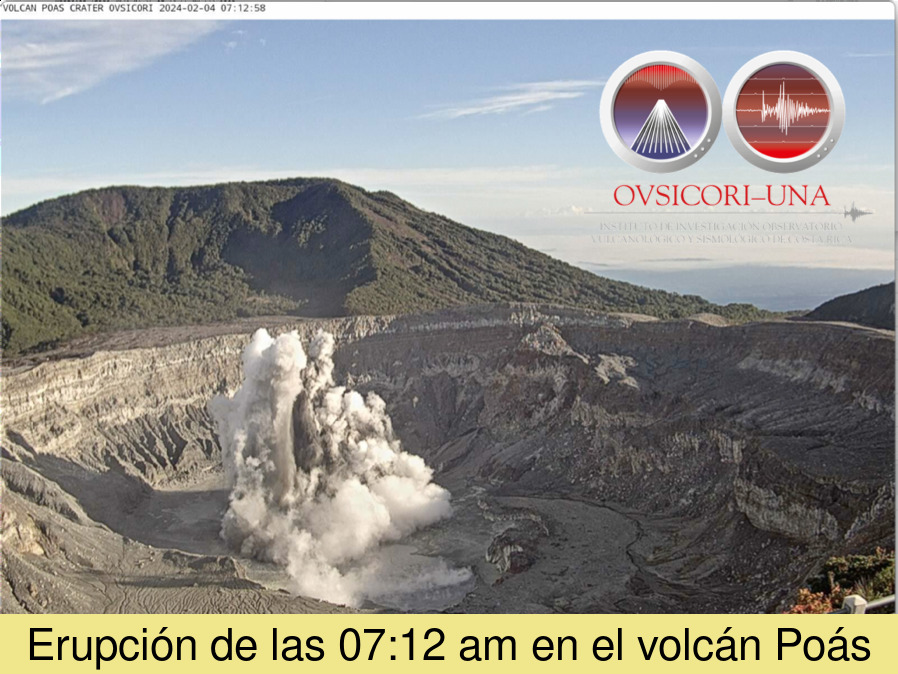
OVSICORI-UNA reported that small and frequent phreatic eruptions on Poás continued from January 30 to February 6. Data from the monitoring network indicated that about 600 events occurred per day, although most of them did not eject material more than 50 m in height, and only a few events ejected material at more than 100 m. On February 4 at 7:12 a.m., a phreatic eruption produced a plume of steam, sediment, and water that rose 200 m. The report notes that small eruptive events were occurring at a rate of 20 to 25 events per hour before the 7:12 a.m. event, ceased afterward, and then resumed at a rate of approximately 20 events per hour. On February 6, incandescence at the vent was visible in webcam images and was attributed to the combustion of native sulfur. This phenomenon was last visible in 2019.
Source : Ovsicori , GVP.
Hawaii , Kilauea :
Thursday, February 8, 2024, 9:30 AM HST (Thursday, February 8, 2024, 19:30 UTC)
19°25’16 » N 155°17’13 » W,
Summit Elevation 4091 ft (1247 m)
Current Volcano Alert Level: ADVISORY
Current Aviation Color Code: YELLOW
Activity Summary:
Kīlauea volcano is not erupting. Seismicity at the summit and along the Koa‘e fault system southwest of the summit continues to decrease following an intrusion of magma into the area.
Summit Observations:
Seismicity and ground deformation beneath the summit and extending 5-7 miles (8-11 km) southwest of the caldera under the Koa‘e fault zone continues to decrease. Earthquake counts have been holding steady at 1–10 earthquakes per hour; dispersed widely from the summit to the southwest. Depths remain consistent, 1–5 km (0.6-3 mi) below the surface, and magnitudes are typically below 3.0. The total number of earthquakes in the area has decreased with approximately 36 earthquakes recorded across this region over the past 24 hours.
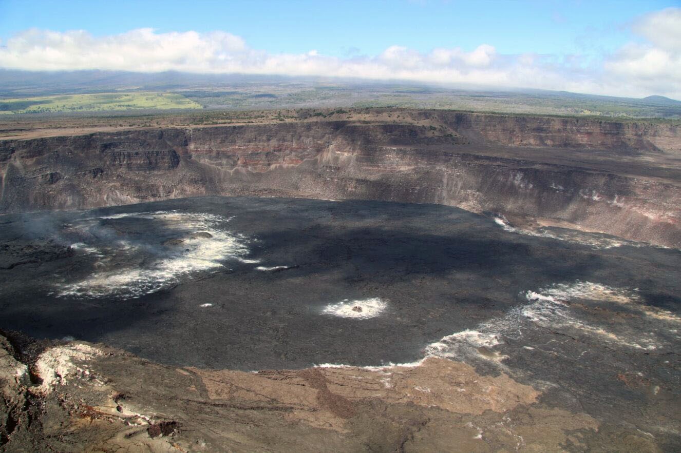
HVO geologists conducted an overflight of Halema‘uma‘u, Kaluapele (Kīlauea summit caldera), the Koa‘e fault system, and the upper Southwest Rift Zone of Kīlauea on February 6, 2024. This aerial view of Halema‘uma‘u shows the fumarolic areas marked by white alteration that have developed on the lava flows that make up the floor of Halema‘uma‘u.
Over the past day, tiltmeters near Sand Hill and Uēkahuna bluff have recorded little change, both on a mild deflationary trend.
Sulfur dioxide (SO2) gas emission rates have remained low since October 2023. An SO2 emission rate of approximately 70 tonnes per day was recorded on January 17.
Rift Zone Observations:
Seismicity in Kīlauea’s upper East Rift Zone and Southwest Rift Zone remain low. No unusual activity has been noted along the middle and lower sections of Kīlauea’s East Rift Zone. We continue to closely monitor both rift zones.
Source : HVO
Photo : USGS / H. Winslow.