June 13 , 2018.
Pu’u ‘Ō’ō / Kilauea , Hawai :
Monday, June 11, 2018, 10:32 PM HST (Tuesday, June 12, 2018, 08:32 UTC)
19°25’16 » N 155°17’13 » W,
Summit Elevation 4091 ft (1247 m)
Current Volcano Alert Level: WARNING
Current Aviation Color Code: RED
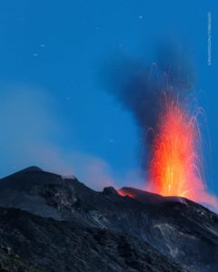
Kīlauea Volcano Lower East Rift Zone
Eruption of lava continues from the lower East Rift Zone (LERZ) fissure system in the area of Leilani Estates.
A line of closely spaced vents at Fissure 8 are continuing to erupt producing fountains reaching heights up to 160 feet, just higher than the spatter cone around them. This activity continues to feed the fast moving channelized flow that is entering the ocean at Kapoho. Weak spattering is continuing at Fissures 16 & 18 as has been noted for the last several days. This evening’s over flight showed a strong steam plume on the south end of the ocean entry with frequent steam explosions at the flow front.
https://www.facebook.com/alertaperiodismoalternativo/videos/2110551045828021/
Pele’s hair and other lightweight volcanic glass from fountaining of Fissure 8 are falling downwind of the fissure and accumulating on the ground within Leilani Estates. High winds may waft lighter particles to greater distances. Residents are urged to minimize exposure to these volcanic particles, which can cause skin and eye irritation similar to volcanic ash.
HVO field crews are on site tracking the fountains, lava flows, and spattering from Fissure 8 as conditions allow and are reporting information to Hawaii County Civil Defense. Observations are also collected on a daily basis from cracks in the area of Highway 130; no changes in temperature, crack width, or gas emissions have been noted for several days.
Volcanic gas emissions remain very high from Fissure 8 eruptions. Gas emissions have increased over the past two weeks. Trade wind conditions are expected to bring vog to the south and west sides of the Island of Hawaii.
Kīlauea Volcano Summit
Seismicity levels have been increasing since the small explosion this morning. There have been no significant ash emissions since that early morning event. If the pattern of seismic increase seen before previous explosions continues to repeat we expect there may be another event in the next 6-12 hours. Inward slumping of the rim and walls of Halema`uma`u continues in response to ongoing subsidence at the summit.
Sulfur dioxide emissions from the volcano’s summit have dropped to levels that are about half those measured prior to the onset of the current episode of eruptive activity. This gas and minor amounts of ash are being transported downwind, with small bursts of ash and gas accompanying intermittent explosive activity.
Amazing Sunrise Lava on Lava Boat Tour 6/12/18 from shane turpin on Vimeo.
Tuesday, June 12, 2018, 8:54 AM HST (Tuesday, June 12, 2018, 18:54 UTC)
Kīlauea Volcano Lower East Rift Zone
Eruption of lava continues from the lower East Rift Zone (LERZ) fissure system in the area of Leilani Estates.
A line of closely spaced vents at Fissure 8 are continuing to erupt producing fountains reaching heights up to 160 feet, just higher than the spatter cone around them. This activity continues to feed the fast moving channelized flow that is entering the ocean at Kapoho. Weak spattering is continuing at Fissures 16/8 as has been noted for the last several days. This morning’s overflight observed a small overflow of a minor pond on the east side of Fissure 8 that did not extend beyond earlier Fissure 8 lavas. Lava was entering the ocean over a broader length this morning with several minor incandescent points and small plumes and two larger entries and corresponding plumes. The upwelling areas were also more dispersed than yesterday.
Kīlauea Volcano Summit
At 1:52 AM HST, another small ash-poor explosion occurred at Kīlauea’s summit. This event and many of its precursory earthquakes were widely felt in the Volcano area. Seismicity dropped following the event as it typically has with recent explosions. Inward slumping of the rim and walls of Halema`uma`u continues in response to ongoing subsidence at the summit.
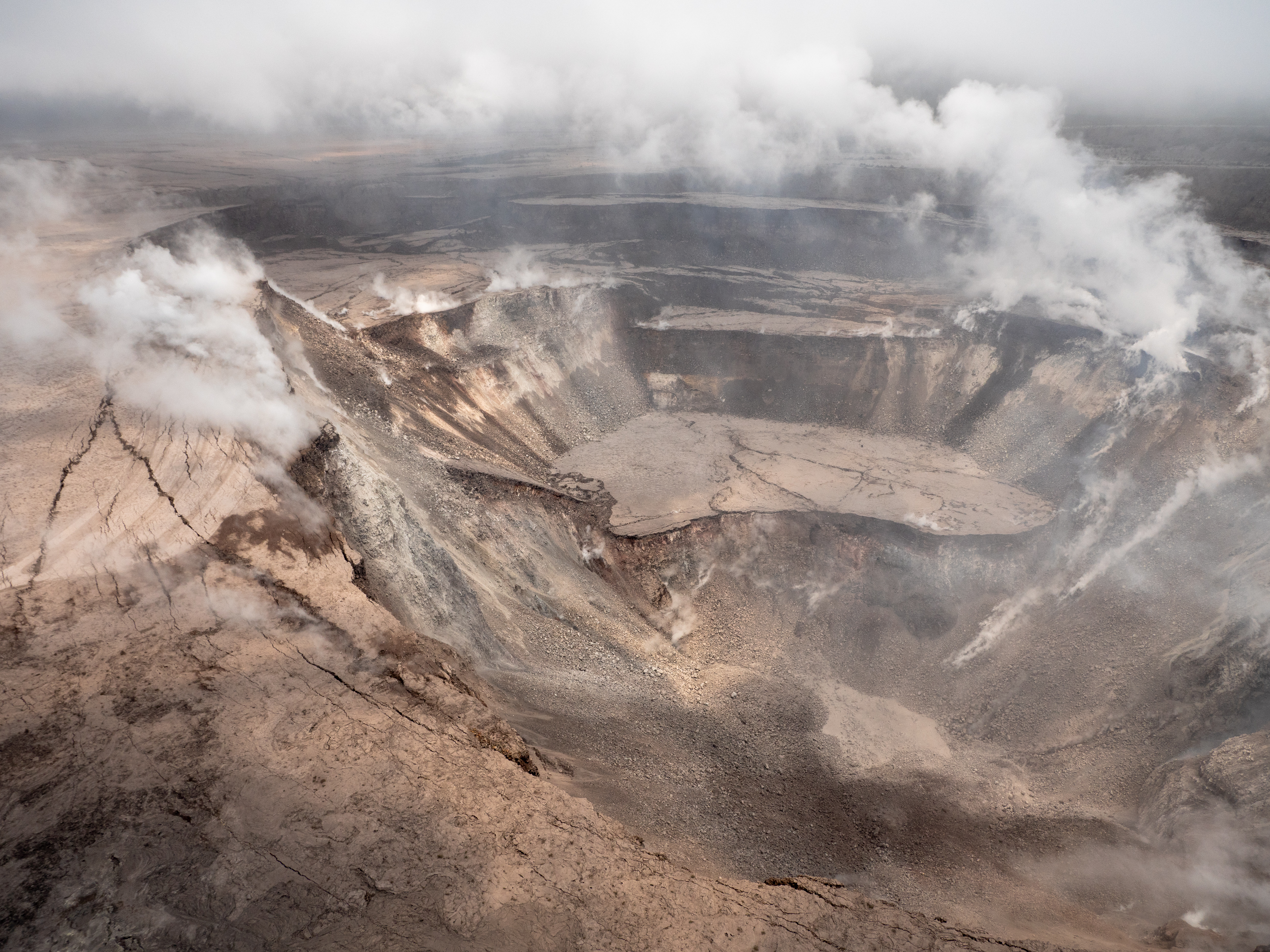
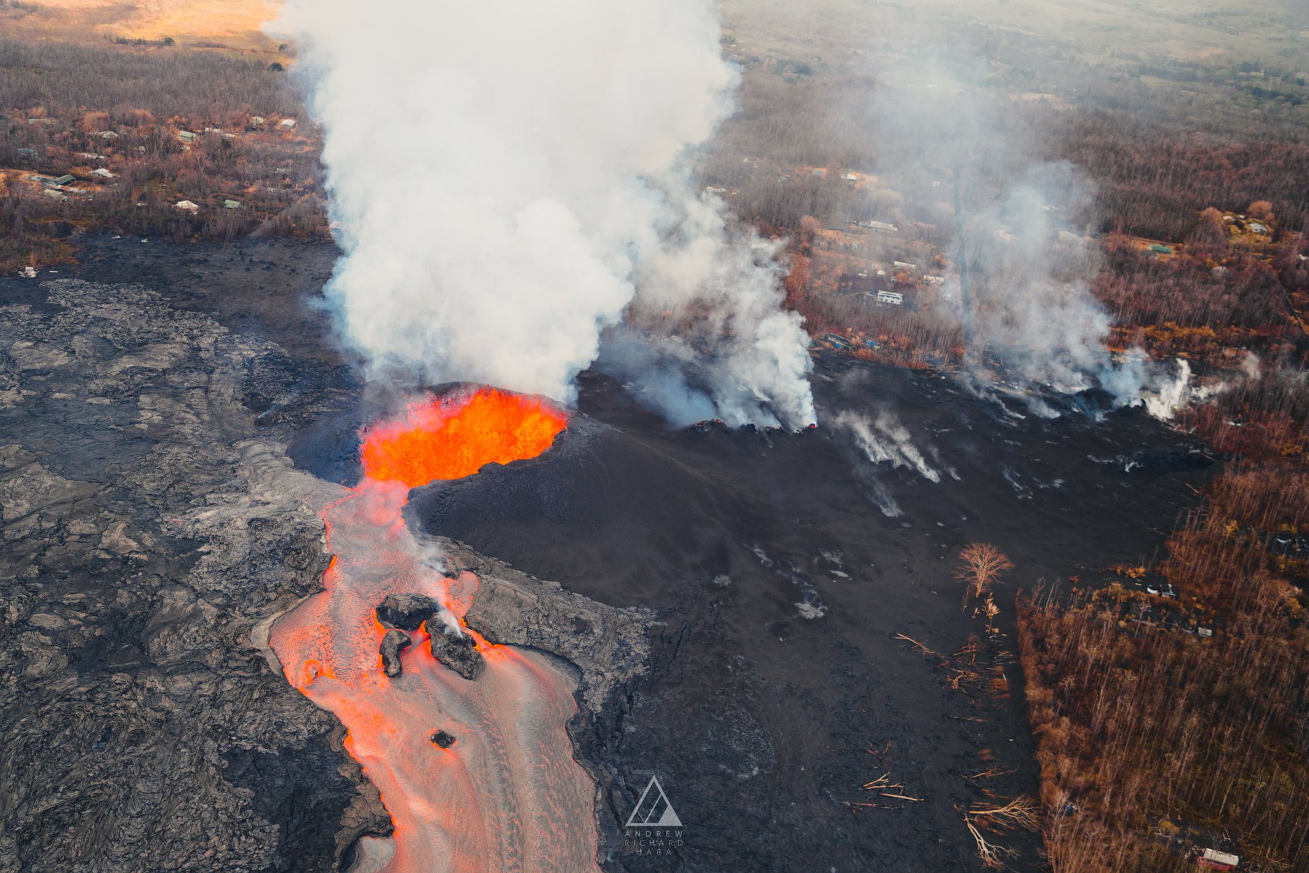
Events at the summit of Kīlauea over the past few weeks have dramatically reshaped Halema‘uma‘u, shown here in this aerial view, which looks west across the crater. The obvious flat surface (photo center) is the former Halema‘uma‘u crater floor, which has subsided at least 100 m (about 300 ft) during the past couple weeks. Ground cracks circumferential to the crater rim can be seen cutting across the parking lot (left) for the former Halema‘uma‘u visitor overlook (closed since 2008). The deepest part of Halema‘uma‘u (foreground) is now about 300 m (1,000 ft) below the crater rim. The Halema‘uma‘u crater rim and walls continue to slump inward and downward with ongoing subsidence at Kīlauea’s summit.
Sulfur dioxide emissions from the volcano’s summit have dropped to levels that are about half those measured prior to the onset of the current episode of eruptive activity. This gas and minor amounts of ash are being transported downwind, with small bursts of ash and gas accompanying intermittent explosive activity.
Tuesday, June 12, 2018, 4:12 PM HST (Wednesday, June 13, 2018, 02:12 UTC)
Kīlauea Volcano Lower East Rift Zone
Eruption of lava continues from the lower East Rift Zone (LERZ) fissure system in the area of Leilani Estates.
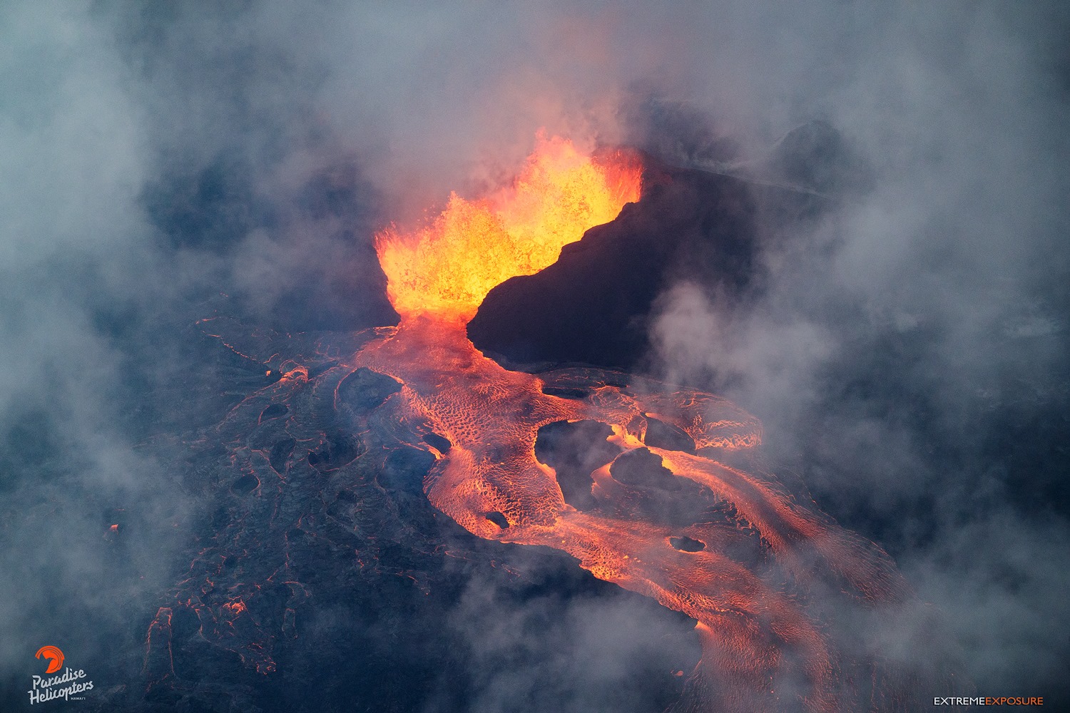
A line of closely spaced vents at Fissure 8 are continuing to erupt producing fountains encircled by a 115-ft spatter cone. This activity continues to feed the fast moving channelized flow that is entering the ocean at Kapoho. Weak lava activity continues at Fissures 16/18 as has been noted for the last several days. Incandescence was noted at Fissures 15 and 22. Lava was entering the ocean over a broader length this morning with several minor incandescent points and small plumes and two larger entries and corresponding plumes. The upwelling areas were also more dispersed than yesterday.
Kīlauea Volcano Summit
Seismicity continues to increase after this morning’s explosive eruption. Inward slumping of the rim and walls of Halema`uma`u continues in response to ongoing subsidence at the summit.
Sulfur dioxide emissions from the volcano’s summit have dropped to levels that are about half those measured prior to the onset of the current episode of eruptive activity. This gas and minor amounts of ash are being transported downwind, with small bursts of ash and gas accompanying intermittent explosive activity.
Source : HVO
Video : Alert Rojas, Shane Turpin
Photos : Andrew Hara , Usgs ,
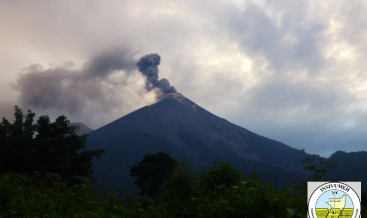
Pacaya , Guatemala :
Guatemala: Pacaya volcano increases activity
In recent months, the volcano has presented lava flows and Strombolian explosions.
The Pacaya volcano, located 50 kilometers south of the Guatemalan capital, increased its activity Tuesday, although it represents no risk to the population, informed an official source.
The National Institute of Seismology, Volcanology, Hydrology Meteorology (INSIVUMEH) reported that the volcano at 2552 meters above sea level recorded strombolian activity.
He added that over the last few months, the volcano has been lava flows, Strombolian explosions, and long-range rumblings.
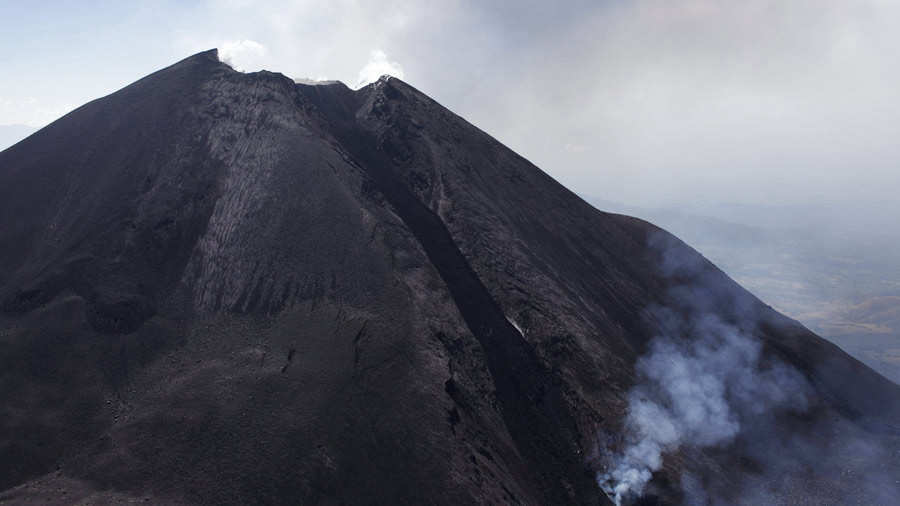
But he warned that during these last hours, the frequency of his explosions has increased, which reach 150 meters above the crater and generate vibrations of the roofs of houses, sensitive to a distance of 10 kilometers in the volcanic perimeter.
The scientifics has warned that the activity of this volcano may increase further in the hours or days to come.
Insivumeh has recommended to the National Coordinator for Disaster Reduction (Conred) to follow the evolution of Pacaya volcano activity and adopt the necessary precautions.
The last eruption of Pacaya, located in the municipality of San Vicente Pacaya, in the southern department of Escuintla, took place in June 2015.
Source : elsalvador.com.
Source : EFE
Fuego , Guatemala :
Volcanological SPECIAL BULLETIN BEFGO # 59-2018 Guatemala 12 June 2018, 19:35 (local time)
Descent of pyroclastic flows in the Seca ravine
Type of activity: Vulcanian
Morphology: Composite Stratovolcan
Location: 14 ° 28’54˝ Latitude N; 90 ° 52’54˝ Longitude W.
Height: 3,763msnm.
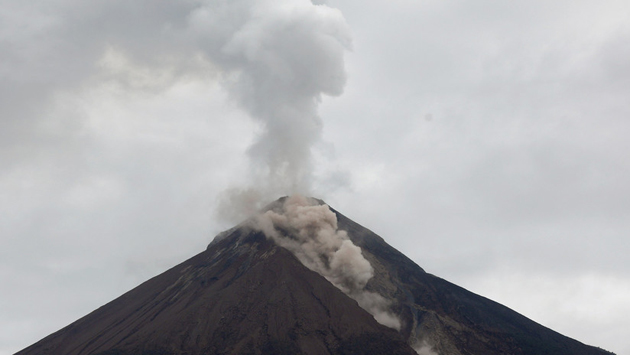
The Fuego volcano is currently experiencing the descent of pyroclastic flows towards the Seca Canyon. It is estimated that this new stream will produce a curtain of ash that will reach 6000 meters above sea level and that it will be dispersed mainly to the North and Northeast depending on the direction of the wind.
It is important to note that pyroclastic flows carry very hot gases and materials, so it is recommended not to stay in or near ravines.
Derived from explosive activity, avalanches constantly appear that produce thick columns of ash that, like pyroclastic flows, are carried by the wind to the north and north-east, so that ashes can fall in this direction .
These events may continue to occur over the next few hours and days, impacting the main ravines.
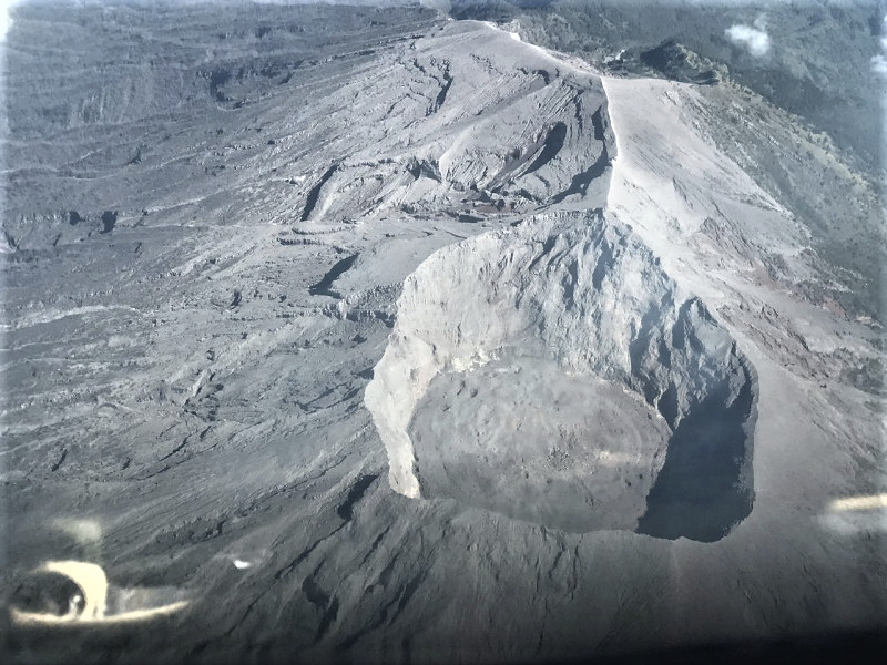
FUEGO VOLCANO AIR RECONNAISSANCE REPORT JUNE 10, 2018
Derived from the activity of June 3 has remained a constant monitoring of the activity of the Fuego volcano. For this reason, on June 10 at 07:50 an aerial inspection of the volcanic structure was carried out. The points inspected were: current activity, crater morphology and general condition of the ravines that exhibited volcanic activity.
Status of the activity
During the visit, it was observed that the main explosive activity is concentrated in the central part of the crater. Explosions develop in the crater area, it is estimated that degassing plumes reach between 4500 and 4700 m (14763 to 15420 feet); These columns are supported because the wind is calm.
Derived from the explosions, avalanches are generated towards the Barranca Las Lajas, Ceniza and mainly Seca, by moving blocks of volcanic matter that are unstable in the crater area and raising ash columns in their path, which do not exceed crater height.
Morphology of the crater
It has been observed that, unlike recent eruptions, the current morphology of the crater has not shown any change, that is, it retains its conical structure. The formation of a new crater was not obvious, however there is presence of fumarolic activity in the lower crater, an activity that may be associated with a crack where activity has already been observed.
State of the ravines:
Regarding the ravine observations around the Fuego Volcano, 4 of them have new pyroclastic materials. Those with the greatest amount of volcanic material are the Las Lajas and Seca ravines, which are located first to the southeast and the second to the southwest. Ceniza Canyon and Taniluyá Canyon both have materials but in smaller quantities. It has been observed that on the way of pyroclastic flow deposits, gully (canals) began to form due to the action of the last rains which began to remove the most superficial material composed of ash layer.
Conclusions:
Currently, there is a characteristic activity of the Fuego Volcano with degassing columns and occasional avalanches. The eruption of June 3 did not develop in the central part of the crater since the field evidence shows no change in its morphology. A strong accumulation of volcanic material has been observed in the Las Lajas, Seca, Taniluyá and Ceniza ravines, this situation will continue to generate moderate and strong lahars on a recurrent basis, mainly during the current rainy season when heavy rains are expected.
Source : Insivumeh
Photos : Insivumeh
Agung , Indonesia :
VOLCANO OBSERVATORY NOTICE FOR AVIATION – VONA.
Issued: June 13 , 2018.
Volcano: Agung (264020)
Current Aviation Colour Code: ORANGE
Previous Aviation Colour Code: orange
Source: Agung Volcano Observatory
Notice Number: 2018AGU27
Volcano Location: S 08 deg 20 min 31 sec E 115 deg 30 min 29 sec
Area: Bali, Indonesia
Summit Elevation: 10054 FT (3142 M)
Volcanic Activity Summary:
Eruption with volcanic ash cloud at 03h05 UTC ( 11h05local). Eruption and ash emission is not continuing.
Volcanic Cloud Height:
Best estimate of ash-cloud top is around 16454 FT (5142 M) above sea level, may be higher than what can be observed clearly. Source of height data: ground observer.
Other Volcanic Cloud Information:
Ash-cloud moving to west dan southwest
Remarks:
seismic activity is dominated by volcanic earthquake
Mount Agung has been erupting since November 21, 2017, and until now eruption activity still occurred occasionally on a small scale. The PVMBG continues to monitor intensively the activities of Gunung Agung 24 hours a day. Here we present an evaluation of Gunung Agung’s activities from 1 May to 7 June 2018:
Visual:
The weather is usually observed as bright, cloudy or rainy, the wind blows weakly to moderately to the west and east. Fumes dominated by water vapor and volcanic ash products were observed at a height of 50 to 1000 meters above the summit of the peak. The latest VONA report delivered an Orange color code. The volume of the last lava dome was about 23 million m3 (about a third of the empty volume of the crater).
Seismicity:
High and low frequency earthquakes are still recorded indicating the weak movement of the magma from the depth to the surface. Recorded seismicity indicates two eruption earthquakes, 223 emission earthquakes, 3 harmonic tremors, 1 low frequency earthquake, 80 shallow volcanic earthquakes, 65 volcanic earthquakes, 23 earthquakes Tectonics Local, two earthquakes felt, 110 earthquakes tectonic.
Deformation:
The GPS and Tiltmetre measurements generally show long-term trends (from December 2017 to early June 2018) in the form of deflation. But for the short term that starts from the second week of May 2018 so far, the trend of inflation is observed. The result of the deformation modeling indicates that there is still a build-up of magma pressure at a depth of about 3-4 km below the peak.
Geochemistry:
The SO2 gas measured using the DOAS scanner shows the flux in the range of 190 to 203 tons / day. Measurement of SO2 gas indicates that there is always a contribution of magma from the depth to the surface.
Satellite:
The satellites still record the existence of Hotspot in the crater of Mount Agung. This indicates the presence of hot lava material that can be caused by the existence of an effusion / flow of magma on the surface of the crater but with a low rate.
Conclusions and recommendations
– The level of activity of Gunung Agung is still at level III (Siaga). The volcanic activity of Gunung Agung is still relatively high, not yet stable and still has the potential for eruption.
– If an eruption occurs at this time, the eruptive material can still be located within a radius of 4 km around the summit. Outside the area, communities can do normal activities as usual. For now, there is still no need for evacuation because the potential danger has not threatened facilities and people around Gunung Agung.
– People must prepare a mask to avoid the dangers of volcanic ash for health if at any time the eruption of Mount Agung occurs.
– The public must remain calm while maintaining the preparation because the activity of Mount Agung has not returned to normal.
– Information on the activity of Mount Agung is constantly updated every 6 hours and if people need more specific information, contact the Volcano Observation Station located in Rendang and Batulompeh.
Source : Magma Indonesia , Centre de Volcanologie et d’Atténuation des Risques Géologiques